This Craighead County Map page provides four high-resolution JPG originals in a downloadable ZIP, together with web previews for roads, major cities, waterways, and elevation. Jonesboro is the easiest place to begin because it is the county’s largest mapped urban area and sits where several important roads meet the higher ground of Crowley’s Ridge. Lake City lies well to the east, while Bono and Brookland are north of Jonesboro, Bay is to the south, and Monette and Caraway occupy the eastern lowlands. Reading the county from west to east reveals a strong contrast between the Cache River side, the central ridge, and the St. Francis River side.
Craighead County also has an unusual administrative geography. County government maintains major courthouse functions in Jonesboro and an Eastern District courthouse in Lake City, and trusted county history sources describe both places as county-seat centers. That division makes geographic sense on the map because the two cities are separated by a considerable distance and by a noticeable change in terrain. Jonesboro is associated with the ridge and denser road network, while Lake City sits in the flatter eastern part of the county close to the St. Francis River system.
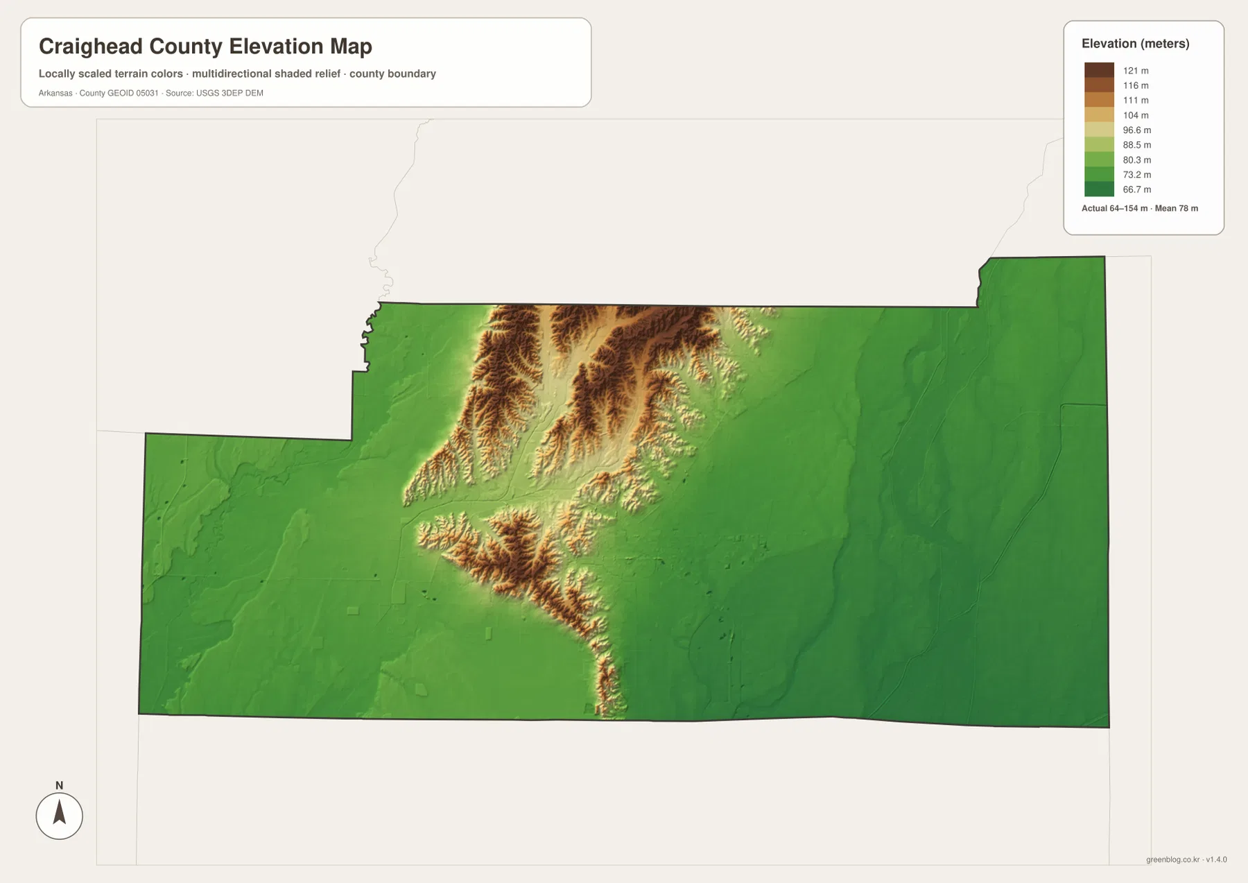
The supplied elevation map reports an actual range of about 64 to 154 meters, with a mean near 78 meters. Most of the western and eastern parts of the county are broad green lowlands, but a band of tan and brown relief rises through the center and north. This is Crowley’s Ridge, the distinctive upland that crosses northeastern Arkansas. Jonesboro lies on and beside this higher ground. The contrast is strong enough that the county’s physical structure can be understood even before any road or river labels are read.
Table of Contents
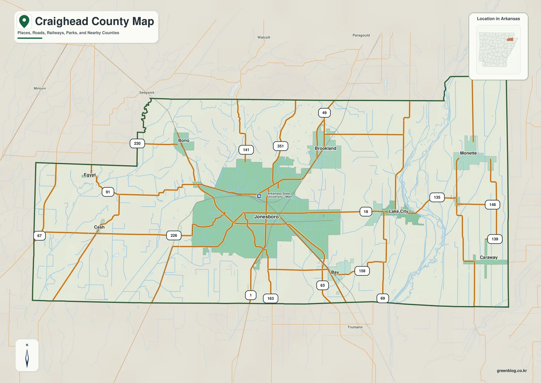
Jonesboro ties the road network together before Route 18 reaches Lake City
On the general county map, Jonesboro dominates the central-western urban area and has roads branching in several directions. Route 18 runs east toward Lake City, while Routes 49 and 351 continue north toward the Brookland side. South of Jonesboro, Routes 1, 163, and 63 are visible, with Bay positioned farther to the southeast. Once Jonesboro is fixed as the main anchor, the rest of the county is much easier to organize because the north, east, south, and west communities fall into distinct groups.
Bono and Brookland are both north of Jonesboro but sit on different sides of the northern road network. Bono is northwest near Routes 230 and 141, while Brookland is farther east near Routes 49 and 351. Between them and Jonesboro, the road lines cross the broken terrain of Crowley’s Ridge. Some routes follow relatively straight paths on flatter ground, while others bend as they move through the ridge and its small valleys.
Following Route 18 east from Jonesboro leads toward Lake City. Monette lies farther northeast and is associated with Routes 135 and 148, while Caraway is farther south near Route 139. The eastern side looks noticeably different from the Jonesboro area: towns are smaller, the landscape is more open, and many roads run in long straight segments across low terrain. The long eastern boundary also makes Monette and Caraway useful points for understanding the county’s position next to Mississippi County.
West of Jonesboro, Cash and Egypt help define the lower, more rural side of the county. Routes 67, 91, and 226 are visible in this area. The western boundary has a large inward step before extending north again, unlike the comparatively simple eastern side. The water map explains part of this landscape because the Cache River and many smaller drainage channels occupy the low western terrain. The general map is best for orientation, not live traffic or road-closure information.
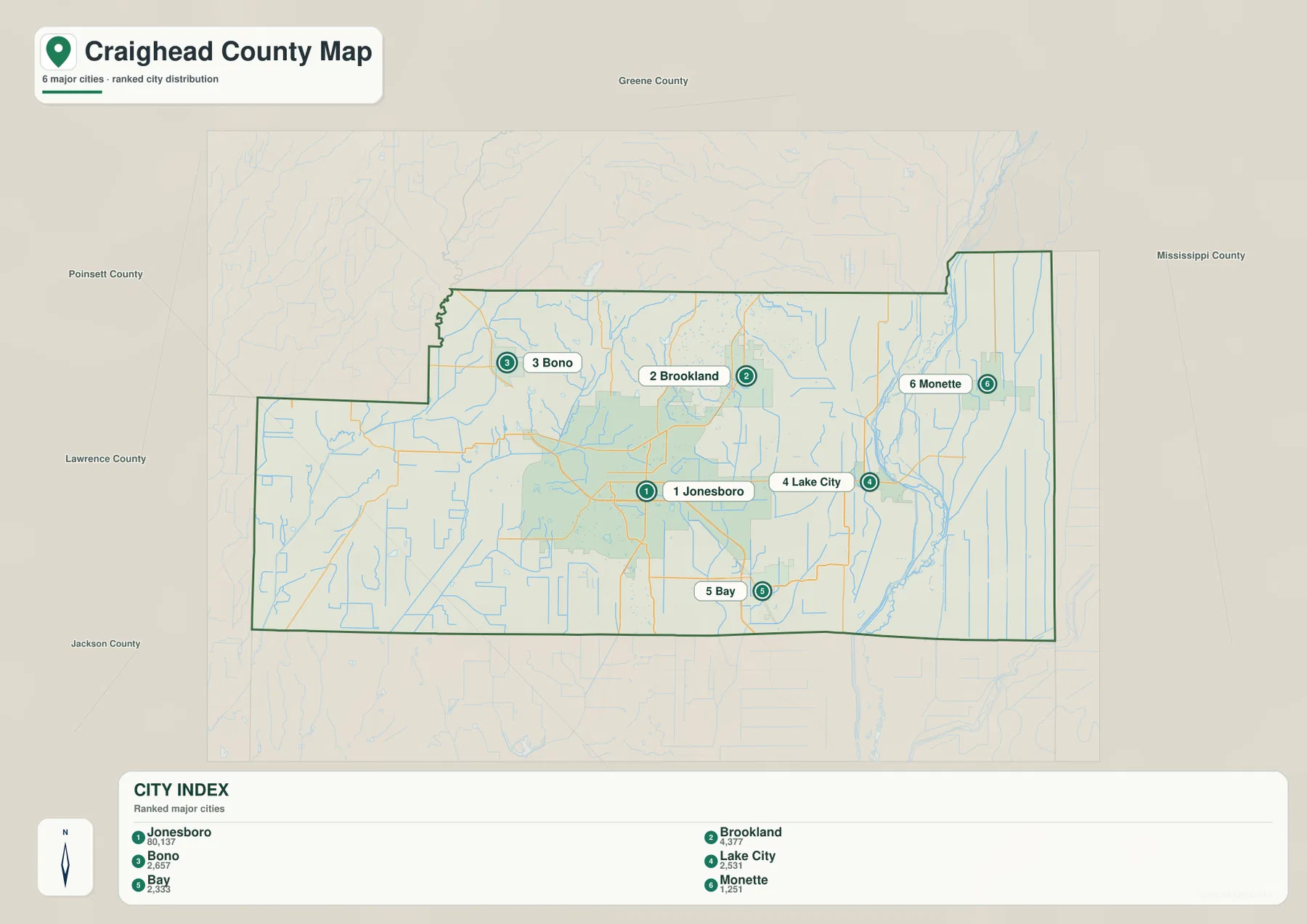
The six-city index makes the Jonesboro cluster and eastern separation easier to see
The city index highlights six places: Jonesboro, Brookland, Bono, Lake City, Bay, and Monette. Jonesboro is ranked first, followed by Brookland, Bono, Lake City, Bay, and Monette. With most secondary roads and community labels removed, the map immediately shows how Jonesboro dominates the county’s settlement pattern. Brookland and Bono sit close to its northern side, while Bay is just south of the main urban area.
Lake City and Monette form a separate eastern group. Lake City lies roughly east of Jonesboro near the St. Francis River corridor, while Monette is farther northeast. The space between Jonesboro and these towns appears much larger when the city layer is simplified. On the detailed map, that gap contains roads, drainage channels, and smaller communities, but the city index helps the reader understand that the principal settlements are not evenly spaced across the county.
The two courthouse districts add useful context to this separation. Jonesboro serves the western side of county government, while Lake City has the Eastern District courthouse. The official county website lists government locations in both cities. Geography helps explain why this arrangement developed: moving from Jonesboro toward Lake City means leaving the higher Crowley’s Ridge area and entering the broad eastern lowland near the St. Francis River.
Labels outside the county include Greene County to the north, Mississippi County to the east, Poinsett County to the south, and Lawrence and Jackson counties to the west and southwest. These neighboring names give the city map regional context and show how Craighead County stretches across northeastern Arkansas. The city index is intended for relative location rather than road mileage or travel-time calculations.
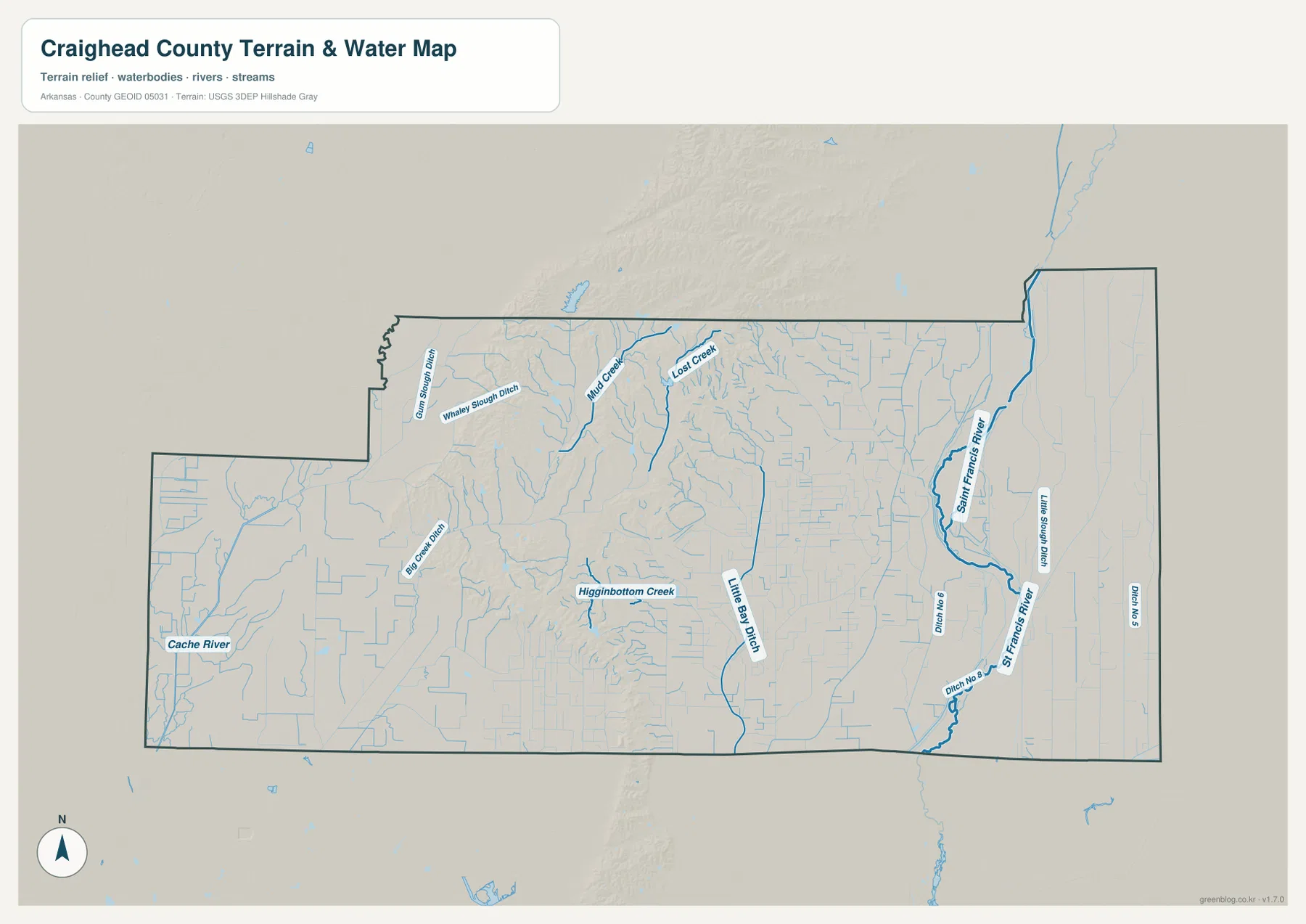
Cache River and St. Francis River frame a county crossed by creeks and drainage ditches
The water map gives the western side of the county a different character from the road map. Cache River is the major named river along the west. Nearby lowlands contain many narrow channels and drainage lines, including Whaley Slough Ditch in the northwest and Big Creek Ditch farther south. Around Cash and Egypt, these water features are more visually important than they appear on the general map because the road layer tends to draw attention away from the dense drainage network.
Closer to the center, Highbottom Creek is labeled in the lower ridge area, and Lost Creek appears farther north. The streams within Crowley’s Ridge tend to be shorter and more irregular than the long straight drainage channels on the surrounding plains. Because the water map includes terrain shading, the relationship is easy to see: small creeks occupy narrow cuts in the higher ground, while ditches and channels spread across the flatter lowlands.
Little Bay Ditch runs through the south-central lowland and is one of the clearest long channels between the ridge and the eastern river system. Moving east toward Lake City, the terrain becomes flatter and the map shows many straight drainage features. This matches the elevation map, where the same broad area is consistently low and green after the ridge drops away.
St. Francis River is the dominant water feature on the eastern side. It bends through the area east of Lake City and is joined by smaller channels. Beyond it, the Monette and Caraway side is crossed by long, nearly straight drainage lines across the low plain. The hydrography layer is a reference for the location of rivers, creeks, and ditches; it does not provide current water level, flood probability, navigation access, parcel boundaries, or legal shoreline limits.
Crowley’s Ridge rises sharply between low western and eastern plains
The elevation map is the clearest way to understand Craighead County’s physical geography. The reported county range is about 64 to 154 meters, with a mean near 78 meters. Broad areas on both the west and east are shown in green, indicating relatively low terrain. In the center and north, tan and dark brown ridges stand well above those plains. That raised belt is Crowley’s Ridge.
The ridge is not a smooth wall. It is broken into narrow spurs, steep-sided valleys, and branching high ground. Southward, some of those ridges spread into finger-like extensions before dropping back to the lower plain. Jonesboro occupies part of this higher landscape, which is one reason the city looks very different on the elevation layer from Lake City and the eastern towns. The Encyclopedia of Arkansas also identifies Jonesboro as a major city on Crowley’s Ridge.
East of the ridge, the terrain falls into a wide lowland toward the St. Francis River. Lake City, Monette, and Caraway are all situated within this broad flatter area. West of the ridge, the Cache River side is also low, although the transition from ridge to plain contains more short valleys and irregular slopes. The result is a county with two low river sides separated by a narrow, distinctive upland.
The 64–154 meter range is appropriate for broad county-scale comparison, not property-level surveying. Construction, drainage design, and engineering work require detailed USGS elevation data or field measurements. This map is most useful for seeing which communities lie on or near the ridge and which occupy the surrounding lowlands.
An eastward trip from Jonesboro is a simple way to remember the county’s changes
One practical mental map begins in Jonesboro and moves east. Jonesboro combines the densest road network with the higher Crowley’s Ridge terrain. Following Route 18 toward Lake City, the ridge gradually gives way to broad low ground. Near Lake City, the St. Francis River becomes a major geographic reference, and farther east or northeast the landscape continues toward Monette and Caraway across a flatter network of roads and drainage channels.
Moving west from Jonesboro creates a different picture. Bono, Cash, and Egypt lead toward the Cache River side, where low terrain is crossed by many ditches and smaller channels. Both the western and eastern sides are low, but they are organized around different river systems. Crowley’s Ridge between them is the feature that makes the county more than a single flat plain.
Brookland and Bono help explain the northern side of the ridge, Bay marks the south side of the Jonesboro-centered settlement area, and Lake City and Monette define the eastern lowland. Remembering those places in relation to the ridge and two river sides is more useful than memorizing every secondary route. It also makes switching between the road, water, and elevation maps much easier.
Choose the road, city, water, or elevation layer according to the detail you need
Use the general county map when you need Jonesboro, the surrounding towns, major route numbers, and the boundary in one view. The six-city index is better for a quick settlement comparison. The water map is the right layer for Cache River, St. Francis River, Little Bay Ditch, Highbottom Creek, and the drainage network. The elevation map provides the most direct explanation of Crowley’s Ridge and the low plains on both sides.
Two layers can be especially useful together. Compare the city and elevation maps to see why Jonesboro and Lake City occupy very different terrain. Compare the road and water maps along Route 18 to understand how the eastern transportation corridor crosses a low landscape filled with channels. These pairings let each map answer a specific question instead of forcing every kind of information into one image.
For printing or close inspection, use the original JPG files instead of enlarging the WebP previews. The ZIP below contains the county map, city map, water map, and elevation map at 3638 × 2572 pixels each. Small road numbers, water labels, and terrain colors are easier to inspect at full resolution, making the files suitable for lessons, presentations, reports, and personal reference.
Frequently Asked Questions
Why are both Jonesboro and Lake City important on a Craighead County map?
Craighead County maintains courthouse functions in both places, with Jonesboro serving the western side and Lake City the Eastern District. They also occupy different geographic settings: Jonesboro is associated with Crowley’s Ridge and the denser road network, while Lake City lies in the flatter eastern lowland near the St. Francis River.
Where does Crowley’s Ridge appear on the elevation map?
It is the band of tan and brown high ground running through the central and northern part of the county. Jonesboro lies on or beside this upland, while the broad green areas to the west and east are lower plains. The supplied elevation map spans about 64 to 154 meters.
Which map is best for Cache River and St. Francis River?
Use the water map. Cache River is the major western river reference and St. Francis River is the main eastern one, with Little Bay Ditch and many smaller channels between them. The layer is for geographic reference and does not show current flood risk, water depth, or legal property boundaries.
Map File Information
The ZIP contains high-resolution JPG originals for the Craighead County general map, city map, water map, and elevation map.
- Included Files: County map, city map, water map, elevation map
- Printable Size: 3638 × 2572 px each
- File Type: JPG
Related Maps
Sources and references
- Official Craighead County website: county government information and courthouse locations in Jonesboro and the Lake City Eastern District.
- Encyclopedia of Arkansas – Craighead County: county history, the two county-seat centers, Crowley’s Ridge, and regional geography.
- U.S. Census Bureau TIGER/Line Shapefiles: official reference for county boundaries, roads, and place geography.
- USGS National Hydrography: official reference for rivers, streams, and drainage features.
- USGS 3D Elevation Program: official elevation and terrain reference.
Green Map creates custom-edited map images using open geographic data sources such as geoBoundaries, Natural Earth, OpenStreetMap, and government open data.
These maps are edited visual materials, not raw data files, and are provided for education, documents, presentations, and graphic reference.