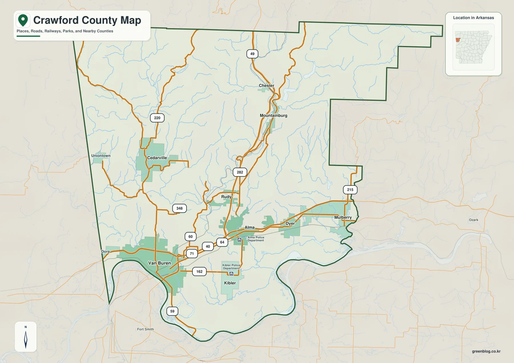
This Crawford County Arkansas Map page includes four high-resolution JPG originals in a downloadable ZIP, together with web previews for roads, major cities, waterways, and elevation. Van Buren is the best place to begin because it sits on the northern side of the Arkansas River and serves as the county seat. Alma lies east of Van Buren near the I-40 and US 64 corridor, while Dyer and Mulberry continue farther east. North of the river-side cities, Mountainburg and Chester occupy narrow valleys in much higher country. Cedarville and Uniontown provide useful western reference points near the Oklahoma side of the county.
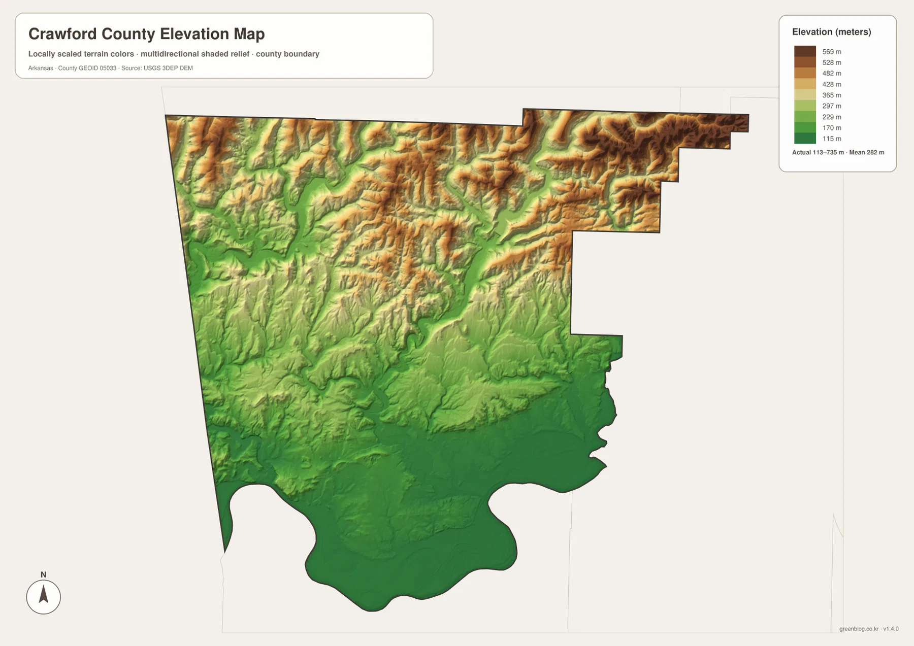
Crawford County changes rapidly from south to north. The official county website describes rugged Ozark terrain in the northern half and lower rolling farmland, forested ridges, isolated mountains, and lakes farther south. The Encyclopedia of Arkansas similarly emphasizes the Boston Mountains in the north and the Arkansas River Valley in the south. The supplied elevation map makes that contrast easy to see: its printed actual range is about 113 to 735 meters, with a mean near 282 meters. Broad dark-green lowlands occupy the southern river side, while the northern third rises into closely packed ridges and valleys.
A simple way to learn the county is to start with the southern line from Van Buren through Alma toward Dyer and Mulberry, then move north toward Mountainburg and Chester. Cedarville and Uniontown can be added on the west. The water map then explains many of the bends in the landscape, showing Lake Fort Smith, Lee Creek, East Cedar Creek, Alma Reservoir, Little Mulberry Creek, and the Arkansas River. The four map subjects answer different questions without requiring the reader to interpret every road, town, stream, and elevation color at once.
Table of Contents
Van Buren and Alma make the southern road network easy to organize
On the general county map, Van Buren occupies the southwestern side immediately north of a broad Arkansas River bend. Interstate 40 runs along the northern side of the city toward Alma, and US 64 follows the same general east-west corridor. US 71 turns north from the Van Buren area, while Route 59 continues south toward Fort Smith. Because the river, the largest city area, and several major roads all meet in one part of the map, Van Buren is the clearest starting point for county-wide orientation.
Alma sits east of Van Buren and functions as another strong transportation reference. I-40 and US 64 pass through the area, while Route 282 and Route 49 lead toward Mountainburg and the northern interior. Dyer and Mulberry continue east from Alma on the lower southern side of the county, with Route 215 appearing near the eastern boundary around Mulberry. Roads here are generally easier to follow than in the rugged north because the terrain is lower and less tightly divided by steep valleys.
West and northwest of Van Buren, Cedarville and Uniontown help define the Oklahoma side. Route 220 and Route 348 are visible around Cedarville, while Uniontown sits closer to the western boundary. Numerous small streams cross this area, so the local roads frequently bend and change direction rather than forming a simple grid. The county’s western edge directly meets Oklahoma, while Sebastian County and Fort Smith lie to the south across and beyond the Arkansas River corridor.
Mountainburg and Chester belong to a very different road setting. Mountainburg stretches along a narrow north-south valley around Routes 49 and 282, and Chester lies farther north along Route 49. Even on the general map, many thin streams crowd the surrounding hills. The elevation layer confirms that these towns sit within the high Boston Mountains section rather than the broad lowland around Van Buren and Alma.
The six-city index separates the Van Buren–Alma core from western and eastern towns
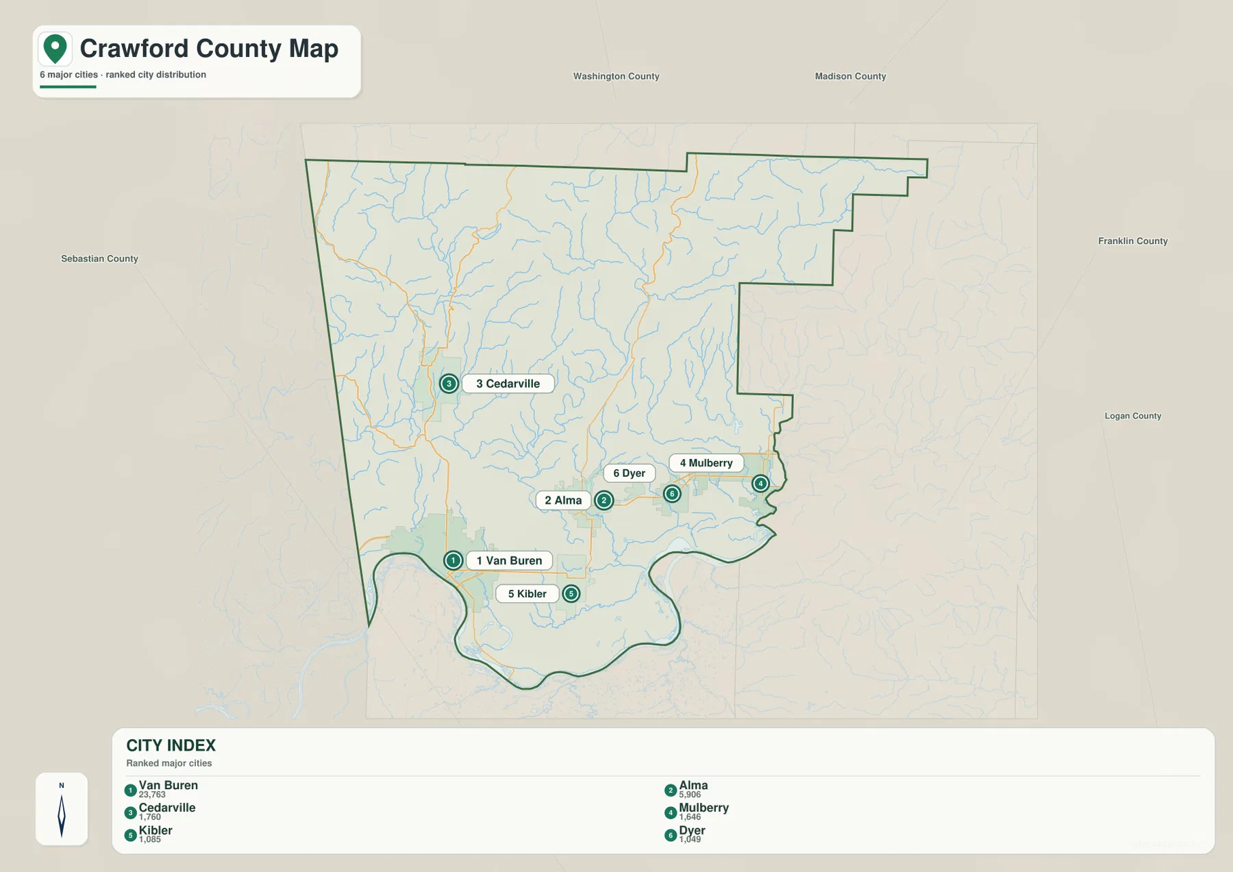
The city index highlights six places: Van Buren, Alma, Cedarville, Mulberry, Kibler, and Dyer. Van Buren is ranked first and Alma second, followed by Cedarville, Mulberry, Kibler, and Dyer. Removing most secondary roads and small place names makes the county’s main settlement pattern much easier to see. Van Buren and Alma form the strongest southern pair, while Cedarville stands apart to the west and Mulberry and Dyer extend the settlement pattern eastward.
Van Buren and Alma are close enough to feel connected on the city map, but their settings are different. Van Buren is tied closely to the Arkansas River bend and the Fort Smith side of the regional urban area. Alma lies farther inland where major roads divide toward the east and north. Kibler sits south of Alma, while Dyer and Mulberry lie to the east. Together, those four places make the southern part of the county look like an east-west corridor rather than one compact city.
Cedarville is the outlier among the six ranked cities. It lies west-central in the county and is separated from the Van Buren–Alma group by rolling ground, streams, and local roads. Uniontown is even farther west but is not included among the six ranked cities on the index. That makes Cedarville a useful simplified marker for the western interior before the map reaches the Oklahoma boundary.
Washington and Madison counties are labeled to the north, Franklin County to the east, and Sebastian County to the south, while Oklahoma lies directly west. These surrounding labels help place Crawford County at the western edge of Arkansas between the Arkansas River Valley and the Ozark highlands. The city index is a relative-location map rather than a driving-distance or travel-time product.
Mountain streams descend from Lake Fort Smith and Lee Creek toward the Arkansas River lowland
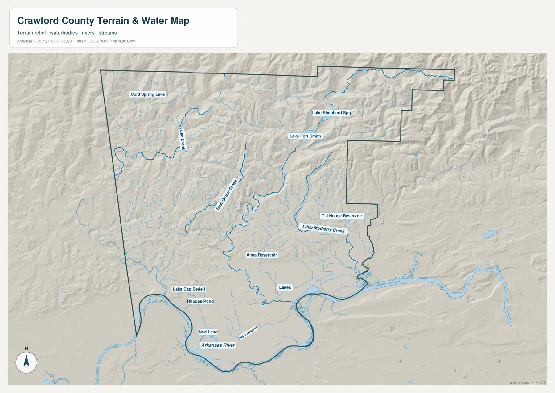
Lake Fort Smith is the strongest named water feature in the northern part of the supplied hydrography map. The reservoir lies in a deep mountain setting and is surrounded by closely spaced ridges and stream valleys. A smaller feature labeled Lake Shepherd Spg appears nearby. The shaded terrain makes it clear that the lake is not sitting in a broad flat basin; narrow valleys and steep surrounding slopes control the shape of the water and the channels leaving the area.
In the northwest, Lee Creek is a major reference and runs through a long valley surrounded by tributaries. Cold Spring Lake is labeled farther north. East Cedar Creek is prominent closer to the west-central interior and follows another low corridor between ridges. Comparing these streams with the county road map helps explain why routes around Cedarville, Mountainburg, and the northern interior bend repeatedly instead of cutting across the terrain in straight lines.
Closer to Alma, Alma Reservoir appears in a lower central valley. Farther east, Little Mulberry Creek follows the terrain toward the Mulberry side, and T J House Reservoir is labeled near the eastern boundary. These water features occupy lower ground than the mountain ridge tops, which becomes obvious when the water map is compared with the elevation layer. The eastern part still has hills, but the terrain is generally lower than the high north.
The Arkansas River dominates the southern edge. It forms a broad bend below Van Buren and continues east along a winding county boundary. Lake Cap Bedell, Rhodes Pond, Ned Lake, and Mays Branch are labeled nearby. Reading the water map from north to south therefore creates a clear progression from mountain reservoirs and narrow creeks to the broad river lowland. The map is for geographic reference and does not provide current flood risk, water depth, boating access, or legal property boundaries.
A 113–735 meter range separates the Arkansas River Valley from the Boston Mountains
The elevation map prints an actual county-wide range of about 113 to 735 meters and a mean near 282 meters. Dark green covers much of the southern Arkansas River side, including the broad Van Buren–Alma–Dyer–Mulberry corridor. Moving north, the colors climb quickly through lighter green, yellow, tan, and brown. The northern third contains the most tightly packed ridges and the deepest-looking valleys, making the south-to-north elevation change the dominant pattern on the map.
The northeast contains some of the most extensive high terrain. Long ridges run through the mountain country with narrow green valleys between them. Lake Fort Smith and its feeder streams occupy those lower cuts. The northwest is also high and rugged, although the ridge spacing and valley width vary from the northeast. The whole northern section is much more broken than the broad lower land near the Arkansas River.
Mountainburg and Chester illustrate that contrast well. On the road map, both towns follow Route 49 in a north-south direction. On the elevation map, the same corridor sits between high ridges instead of across a flat surface. Van Buren and Alma, by comparison, occupy much lower terrain where valleys widen and the city and road networks can spread across a broader area.
This pattern matches authoritative descriptions of Crawford County, which place the Boston Mountains in the north and the Arkansas River Valley in the south. The elevation layer is still a county-scale overview, not a survey product. Construction, drainage design, and engineering work require detailed USGS data or professional field measurements rather than a generalized color surface.
Think of the county as a southern city corridor below a northern mountain block
A practical mental map starts with the Van Buren–Alma–Mulberry side in the south and the Mountainburg–Chester side in the north. The southern corridor follows lower terrain close to the Arkansas River and carries the county’s most prominent roads and urban areas. The northern block contains higher ridges, narrow stream valleys, and Lake Fort Smith. Once those two broad zones are clear, Cedarville and Uniontown can be added on the west without making the county feel complicated.
Van Buren is the best reference for the Arkansas River and Fort Smith side, while Alma marks the point where the major southern corridor connects to roads climbing north toward Mountainburg. Mountainburg and Chester then provide recognizable places inside the Boston Mountains. Cedarville ties the western interior to the Lee Creek and East Cedar Creek valleys, and Mulberry marks the lower eastern side near Little Mulberry Creek.
The water and elevation maps reinforce this north-south division. Broad low ground follows the Arkansas River, while streams in the north descend through narrow mountain valleys. Lake Fort Smith occupies one of those highland basins, Alma Reservoir sits farther south and lower, and Little Mulberry Creek crosses a lower eastern valley. These relationships make Crawford County particularly useful for comparing how roads and settlements change between mountain terrain and a major river valley.
Choose the map based on whether you need roads, towns, water, or relief
The general county map is the best first choice for Van Buren, Alma, Mountainburg, Cedarville, major route numbers, and the county boundary. The six-city index provides a cleaner settlement comparison when road detail is not needed. Use the water map for Lake Fort Smith, Lee Creek, East Cedar Creek, Alma Reservoir, Little Mulberry Creek, and the Arkansas River. The elevation map is the clearest layer for the dramatic change from the southern river lowland to the northern Boston Mountains.
Two layers can also work together. Pair the general map with elevation to see why the road from Alma toward Mountainburg follows a narrower mountain corridor. Pair water with elevation around Lake Fort Smith and Lee Creek to see how streams occupy low valleys between high ridges. These combinations are useful in lessons, reports, and presentations because each image can focus on one kind of information without overwhelming the reader.
For printing or close inspection, use the original JPG files instead of enlarging the WebP previews. The ZIP below contains the county map, city map, water map, and elevation map at 3638 × 2572 pixels each. Small road numbers, stream names, reservoir labels, and terrain colors are easier to inspect at full resolution, making the files suitable for classroom materials, presentations, documents, and personal reference.
Frequently Asked Questions
Where is Van Buren on the Crawford County map?
Van Buren is in the southwestern part of the county immediately north of the Arkansas River. It is the county seat and sits near I-40, US 64, and US 71, making it the strongest road and settlement reference on the general map. The elevation layer places it in the lower Arkansas River Valley rather than the high northern mountains.
Which map is best for Lake Fort Smith and Lee Creek?
Use the water map. Lake Fort Smith is prominent in the northern mountain section, while Lee Creek runs through the northwest. East Cedar Creek, Alma Reservoir, Little Mulberry Creek, and the Arkansas River are also labeled on the same map.
Can the 113–735 meter elevation range be used for surveying?
No. The elevation image is a county-scale reference for comparing the low Arkansas River Valley with the high Boston Mountains. Property-level construction, engineering, or drainage work requires detailed elevation data or professional surveying rather than values read from this overview.
Map File Information
The ZIP contains high-resolution JPG originals for the Crawford County general map, city map, water map, and elevation map.
- Included Files: County map, city map, water map, elevation map
- Printable Size: 3638 × 2572 px each
- File Type: JPG
Related Maps
Sources and references
- Official Crawford County, Arkansas website: county government and Crawford Courthouse information in Van Buren.
- Crawford County official About page: county-specific background on the rugged Ozark north and the lower southern landscape.
- Encyclopedia of Arkansas – Crawford County: background on Van Buren, the Boston Mountains, and the Arkansas River Valley.
- U.S. Census Bureau TIGER/Line Shapefiles: official reference for county boundaries, roads, and place geography.
- USGS National Hydrography: official reference for rivers, streams, and waterbodies.
- USGS 3D Elevation Program: official elevation and terrain reference.
Green Map creates custom-edited map images using open geographic data sources such as geoBoundaries, Natural Earth, OpenStreetMap, and government open data.
These maps are edited visual materials, not raw data files, and are provided for education, documents, presentations, and graphic reference.