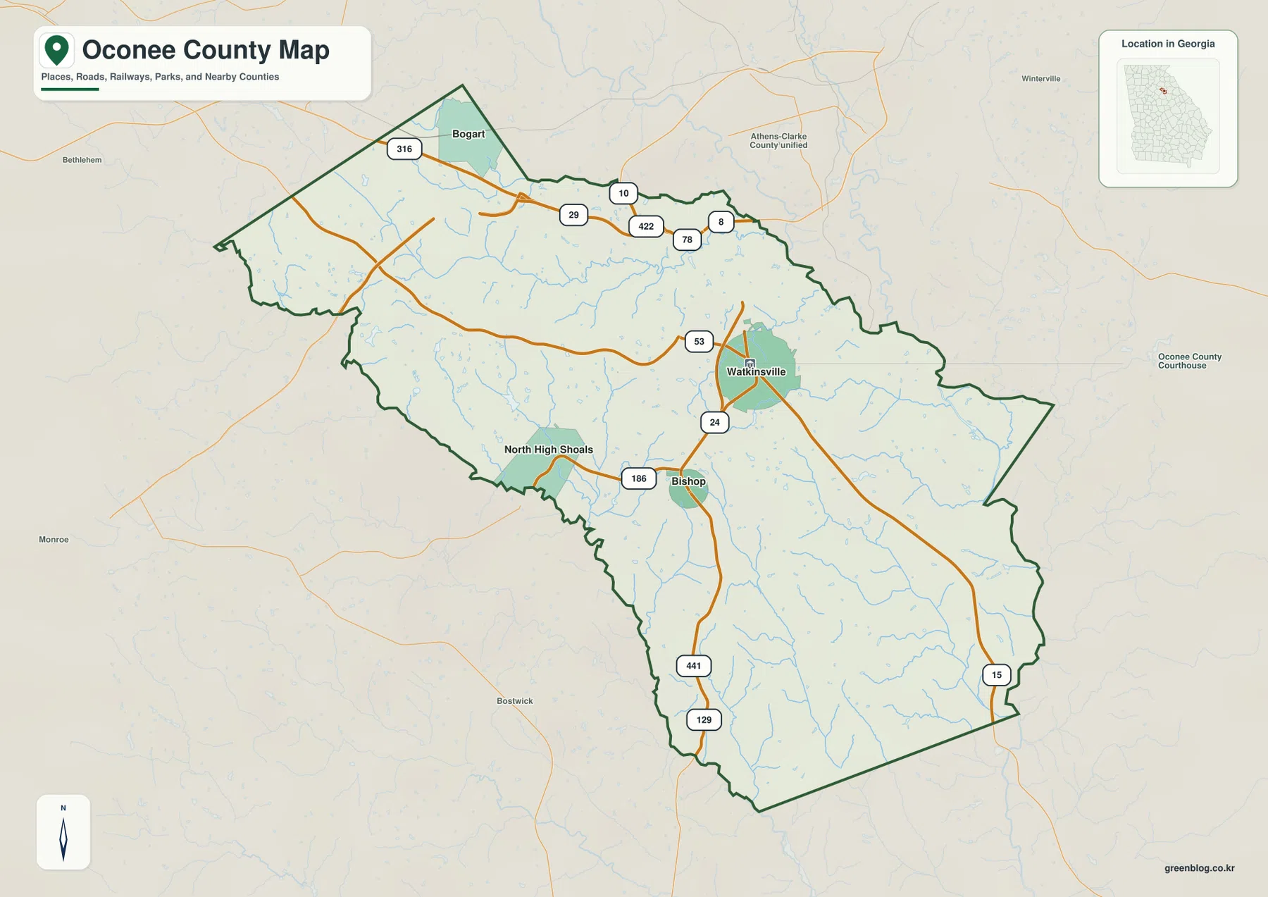
Oconee County sits immediately south of Athens in northeast Georgia, with Watkinsville near the center and the smaller incorporated communities of Bogart, Bishop, and North High Shoals spread toward the county edges. The maps on this page make that compact geography easier to follow: Georgia Highway 316 crosses the northern side toward Athens, the 441/129 corridor runs through the Watkinsville-Bishop area, the Oconee River lines part of the east, and the Apalachee River lies along the western side. Taken together, those features explain much of the county’s settlement pattern and rolling terrain.
The page includes separate views for the county boundary and roads, city connections, waterways, and elevation. The in-page previews use WEBP files for faster loading, while the downloadable package contains four original high-resolution A3 JPG maps in one ZIP. You can use the article to decide which view fits your purpose before downloading the larger files for printing, classroom work, presentations, or general geographic reference.
Table of Contents
Where Oconee County sits below Athens
Oconee County covers about 184 square miles in northeast Georgia. Census geography places it among Clarke, Oglethorpe, Greene, Morgan, Walton, Barrow, and Jackson counties, and the supplied county map makes its relationship with Athens especially clear. Athens-Clarke County is just above the northern edge, while Oconee County stretches south and southeast into a more rural landscape. That position matters because the county is close enough to Athens for commuting and regional shopping, yet much of the interior still reads as a network of small towns, roads, creeks, and wooded or agricultural tracts rather than a continuous urban area.
The county’s history also helps explain why Watkinsville is the central reference point. The New Georgia Encyclopedia notes that Oconee County was created in 1875 from the western part of Clarke County after Athens had replaced Watkinsville as Clarke County’s seat. Watkinsville then became the seat of the new county, and Oconee County took its name from the river that runs along part of its eastern boundary. On the map, that history is visible in a practical way: Watkinsville remains the administrative center while the northern edge faces the much larger Athens area.
This first map is best treated as an orientation map rather than a street atlas or parcel map. It shows the county outline, selected communities, major routes, streams, and neighboring places without trying to label every subdivision or local road. If you are unfamiliar with Oconee County, start here. It establishes where Watkinsville sits, how the long northern extension reaches toward Bogart, and how the broader southern half opens away from Athens before you move to the more specialized city, water, and elevation views.
Watkinsville anchors a small network of towns
Watkinsville is the hub on the city-connections map, but the county’s incorporated places point in several directions rather than forming one continuous line. Bogart sits near the northern tip close to the Athens side of the county. North High Shoals lies against the western edge near the Apalachee River, and Bishop is southwest of Watkinsville along the 441/129 corridor. These towns are small, yet they are useful landmarks because they divide a largely rural county into recognizable northern, western, central, and southern reference areas.
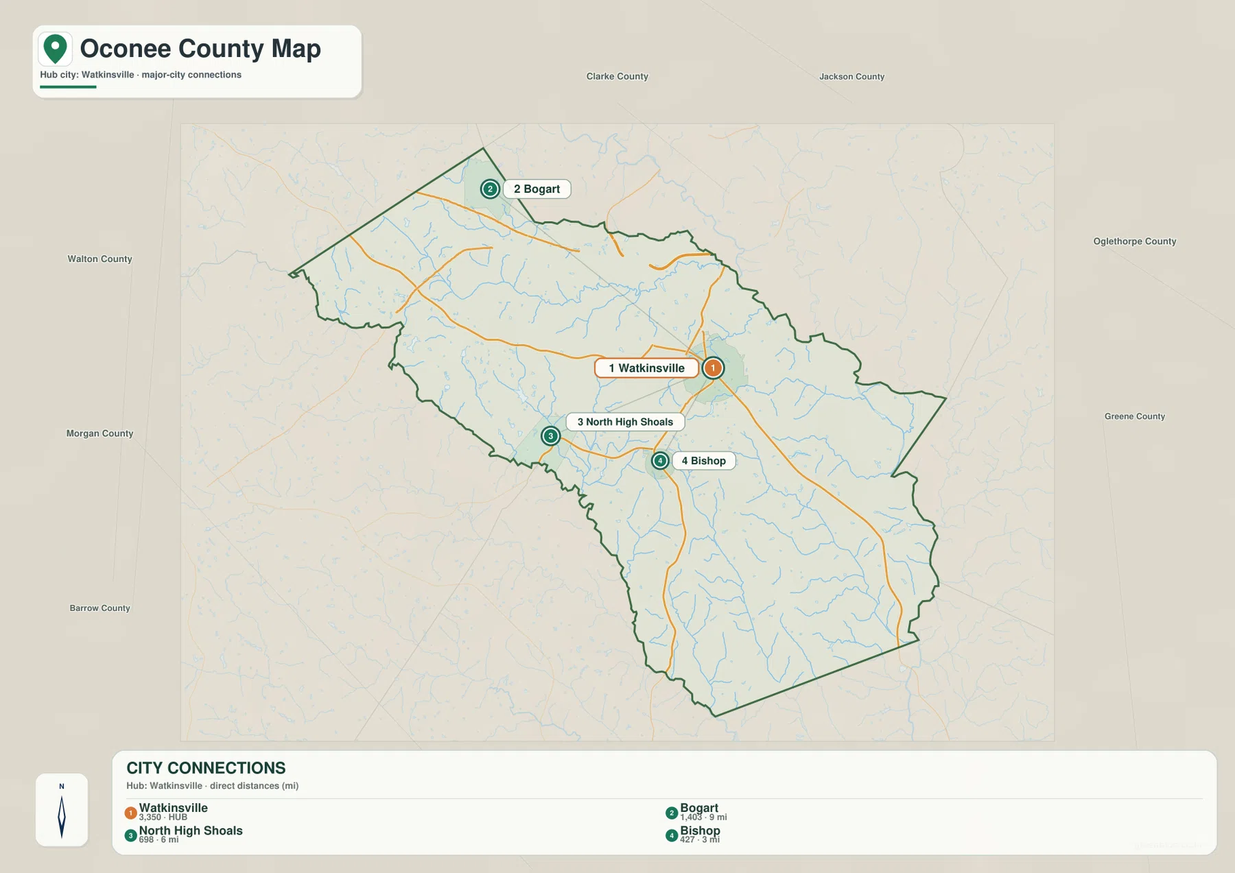
The connector labels show approximate straight-line distances from Watkinsville, not driving mileage. Bishop is marked at about 3 miles, North High Shoals at about 6 miles, and Bogart at about 9 miles from the hub. Those numbers are most useful for comparing relative spacing. A road route can be longer because it must follow the available streets and highways, so the map should not be used to estimate travel time or replace turn-by-turn navigation.
The map also shows why “near Watkinsville” and “near Athens” can mean different things inside the same county. Bogart is much closer to the northern transportation network around Highway 316, while Bishop is tied more directly to the north-south highway route through the county. North High Shoals sits away from both of those corridors on the western side. For a school project or local overview, this city view is more informative than a simple list of municipalities because it shows both direction and separation at a glance.
Highway 316 on the north, 441 and 129 through the middle
Roads help explain the county’s connection to Athens and the different roles of its northern and central areas. Georgia Highway 316 crosses the northern part of Oconee County near Bogart and continues toward Athens. The New Georgia Encyclopedia describes the highway as an important influence on traffic, shopping, development, and property growth in the county. On the map, its position is easy to recognize because it sits close to the narrow northern section rather than passing through the county seat.
Watkinsville is served by routes marked 53 and 24, while the 441/129 corridor continues south through the Bishop area. Route 15 appears farther east and southeast, and Route 186 helps connect the western side near North High Shoals and Bishop. These routes should be read as location cues: Highway 316 is the clearest guide to the Athens-facing north, 441/129 helps organize the central-to-southern part of the county, and the smaller state routes show how Watkinsville connects across the interior.
The county map is not intended to show current congestion, construction, lane configuration, or every minor road. For actual driving, a live road map is the better tool. Here, the value of the road layer is geographic. It lets you compare settlement with the boundary and see why development near the Athens side is different from the more dispersed pattern farther south, while still keeping enough streams and place labels visible to connect the transportation network with the natural landscape.
Two river systems frame the county
The water map gives Oconee County a different shape than the road map does. The Apalachee River follows the western and southwestern side, while the Oconee River is labeled along the eastern side. The Middle Oconee River appears near the northeast, and a dense set of smaller streams runs through the interior. Named examples on the map include Barber Creek, Calls Creek, Porters Creek, Greenbrier Creek, Rose Creek, and McNutt Creek. Several small lakes and impoundments are also visible, but the creek network is the more important countywide feature.
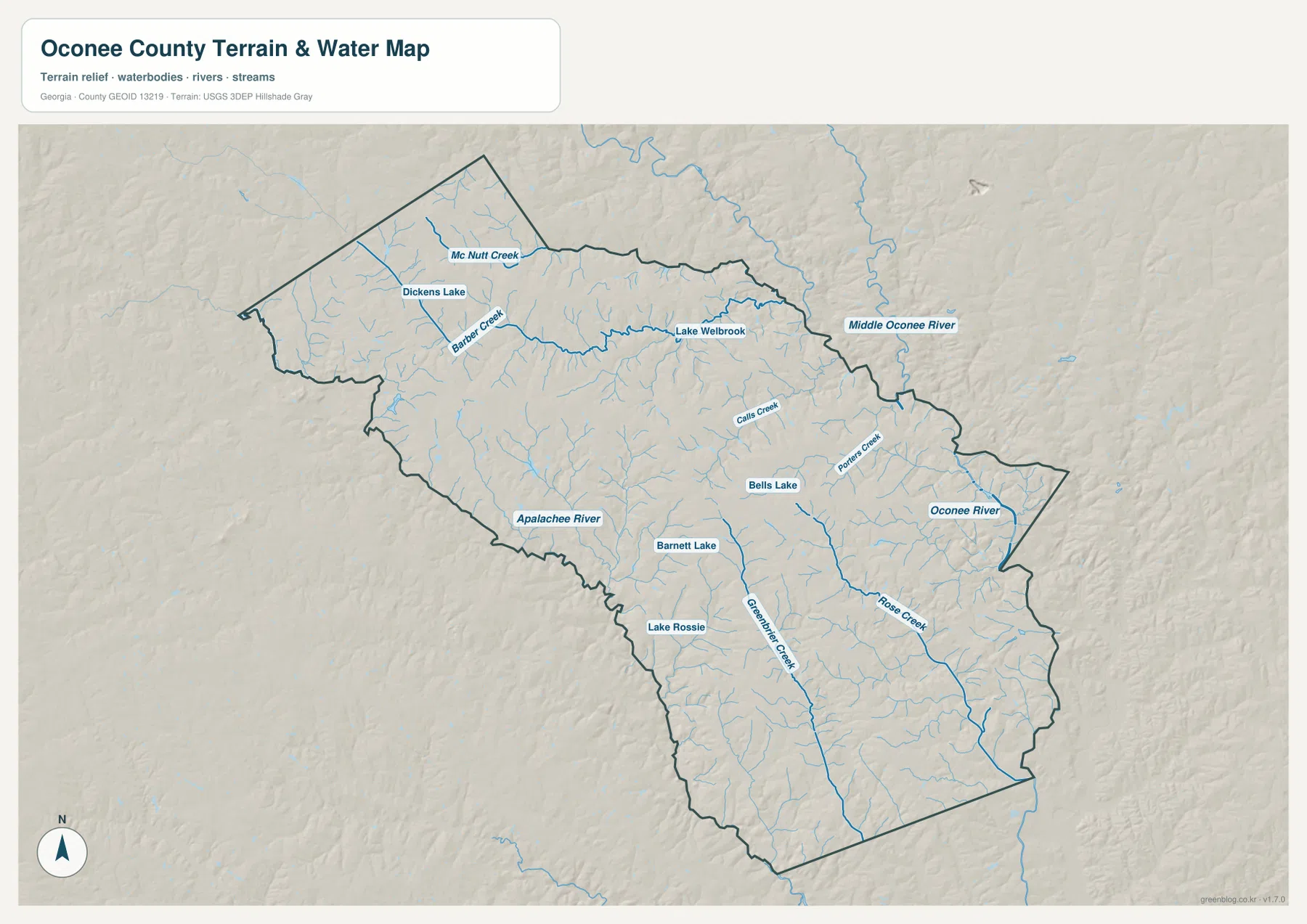
Once the streams are isolated from the road labels, the county’s rolling surface becomes easier to understand. Many short tributaries occupy narrow valleys and converge toward the larger rivers. Greenbrier Creek and Rose Creek are prominent in the southern half, while Barber Creek and Calls Creek help define the northern interior. These watercourses also correspond with lower bands on the elevation map, which is why the water and terrain views work particularly well as a pair.
This is a geographic water-reference map, not a flood-hazard, legal boundary, water-quality, or navigation product. A blue line shows where a mapped stream or river lies at the scale of this county overview; it does not tell you how deep the water is, whether land is inside a regulatory floodplain, or whether a stream can be navigated. Its strongest use is to show which side of the county a river occupies and how tributaries cut across the interior between the towns and roads.
A rolling surface drops toward the river valleys
The elevation map shows a county of ridges and shallow valleys rather than a flat plain. Higher ground is concentrated across much of the northwest and western interior, where the map uses browns and warm tan colors. Lower terrain appears in green along the eastern and southeastern river valleys and in narrow branches that follow creeks through the county. The pattern is subtle compared with a mountain region, but the shaded relief makes the repeated rise-and-fall of the landscape easy to see.
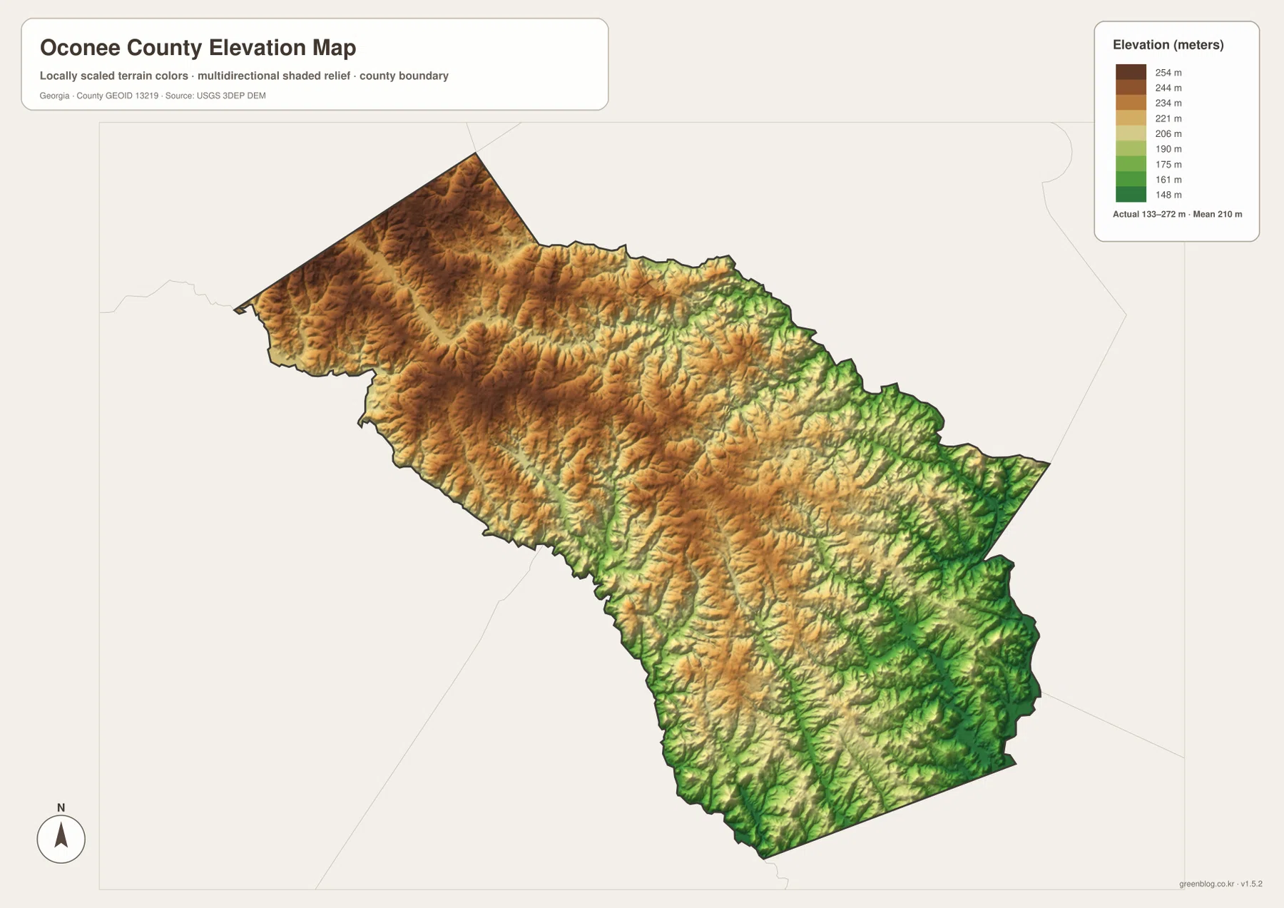
The legend reports an actual elevation range of roughly 133 to 272 meters, with a mean near 210 meters. Those values are useful as a countywide reference, but the colors matter more than any single number when reading the map. Long green strips trace lower drainage corridors, while the warmer colors between them mark higher interstream ridges. When you compare this view with the water map, the relationship is direct: many of the named creeks occupy the lower grooves between higher rolling ground.
Because the surface is generalized for county-scale viewing, this image should not be used for surveying, engineering design, property-level grading, or exact site elevation. It is appropriate for explaining broad terrain, comparing one part of the county with another, or illustrating why stream valleys create so much small-scale relief. If a specific parcel or construction site is the question, use survey-grade measurements or a more detailed official elevation dataset instead.
Choosing the right map for the question
Each map answers a different practical question without forcing every label onto one crowded image. Use the county map when you need the overall boundary, towns, and primary roads. The city-connections view is better when your main question is how Watkinsville relates to Bogart, Bishop, and North High Shoals. The water map removes much of the transportation emphasis so the rivers and tributaries stand out, while the elevation map turns those same valleys and ridges into a clearer terrain picture.
| Map | Best for | Important limitation |
|---|---|---|
| County reference map | Boundary, Watkinsville, small towns, and major road orientation | Not a parcel or complete street map |
| City-connections map | Comparing town locations from Watkinsville | Connector values are straight-line distances, not driving mileage |
| Water map | Oconee and Apalachee rivers, Middle Oconee River, creeks, and small lakes | Not a flood, legal, or navigation map |
| Elevation map | Higher ridges, lower valleys, and countywide relief | Not survey- or engineering-grade elevation |
Pairing two views can be even more useful. A local-history or civics lesson may combine the county and city maps to show why Watkinsville remains central while the northern edge faces Athens. A physical-geography lesson can place the water and elevation maps side by side to show how tributaries follow lower ground toward the larger rivers. For presentations, selecting only the view that supports the point you are making usually produces a cleaner result than placing every map on one slide.
Frequently Asked Questions
Which side of Oconee County is closest to Athens?
The northern side is closest to Athens-Clarke County. Bogart and the Highway 316 corridor sit near that edge, while Watkinsville lies farther south near the county’s center. If you are trying to understand the Athens-Oconee relationship, the northern portion of the county reference map is the best place to start.
Are the 3, 6, and 9 mile city connectors driving distances?
No. The city-connections map uses straight-line distances from Watkinsville. Bishop is shown at about 3 miles, North High Shoals at about 6 miles, and Bogart at about 9 miles from the hub. A driving route will usually be longer because roads do not follow a perfectly direct line, so use a navigation map for travel planning.
Can the elevation map be used for a property survey or engineering plan?
No. The elevation image is a generalized county-scale reference designed to show the broad contrast between higher rolling ground and lower river or creek valleys. It is useful for regional orientation and education, but a property survey, drainage design, grading plan, or construction project requires more precise site-specific elevation data.
Map File Information
The downloadable package contains four original high-resolution A3 JPG maps of Oconee County, covering the county reference view, city connections, waterways, and elevation. One ZIP gives you all four files for printing or offline use.
- File Type: ZIP containing four JPG files
Related Maps
Sources and references
County background was checked against public demographic and historical references, while the map layers correspond to widely used federal boundary, hydrography, and elevation datasets. Use the original sources below when you need current statistics, source documentation, or more detailed geographic data than a county overview can provide.
- U.S. Census Bureau QuickFacts – Oconee County, Georgia
- New Georgia Encyclopedia – Oconee County
- U.S. Census Bureau TIGER/Line Shapefiles
- USGS National Hydrography
- USGS 3D Elevation Program
Green Map creates custom-edited map images using open geographic data sources such as geoBoundaries, Natural Earth, OpenStreetMap, and government open data. These maps are edited visual materials, not raw data files, and are provided for education, documents, presentations, and graphic reference.