You can download the Putnam County Tennessee Map files on this page as one ZIP containing high-resolution JPG versions of the county, city, water, and elevation views. The maps are centered on Cookeville and extend outward to Algood, Baxter, Monterey, major roads, named streams and lakes, and the strong change in relief from the western creek valleys to the higher eastern terrain. The files are suitable for A3 printing as well as presentations, classroom material, and general county reference.
Cookeville is the most useful starting point because it sits near the center of the populated part of the county and is crossed by the main road network. Algood is close to the northeast, Baxter lies to the west, and Monterey is much farther east. When the elevation map is placed beside the county map, the settlement pattern becomes easier to understand: the central and western ground is generally lower, while the eastern side contains much higher ridges and narrow valleys.
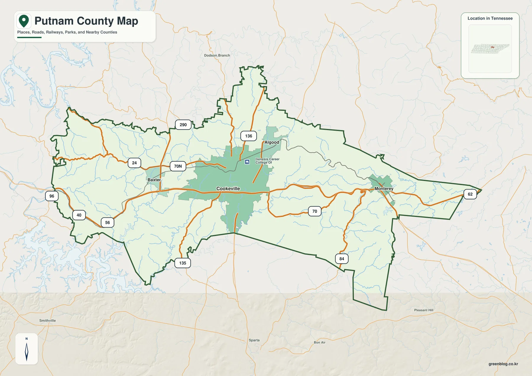
Table of Contents
Cookeville is the main road reference for the county
I-40 provides the clearest east-west route across Putnam County. It passes the Baxter side of the county, crosses the Cookeville area, and continues toward Monterey in the east. US 70N offers another useful reference between Baxter and Cookeville, while SR 111 helps establish a north-south direction through the central area. SR 136 extends north of Cookeville and SR 135 reaches toward the southern boundary, giving the county a road pattern that spreads in several directions rather than following one simple corridor.
The western and eastern road patterns look noticeably different. Around Baxter and the western half, the main routes cross lower terrain and are comparatively open. Around Monterey, roads bend more often as they cross or follow narrow valleys in higher country. The elevation sheet makes that difference easy to see because the east contains broad tan and brown ridges broken by thin green drainage corridors.
Algood sits close to Cookeville on the northeastern side of the urban area, while the county outline continues well north beyond both places. The northeastern extension contains smaller roads and streams that are easy to miss if attention stays only on I-40. A separate southeastern extension also drops south of the main east-west body of the county, showing why the county boundary cannot be understood from the Cookeville urban footprint alone.
Cookeville, Algood, Baxter, and Monterey form a clear east-west settlement pattern
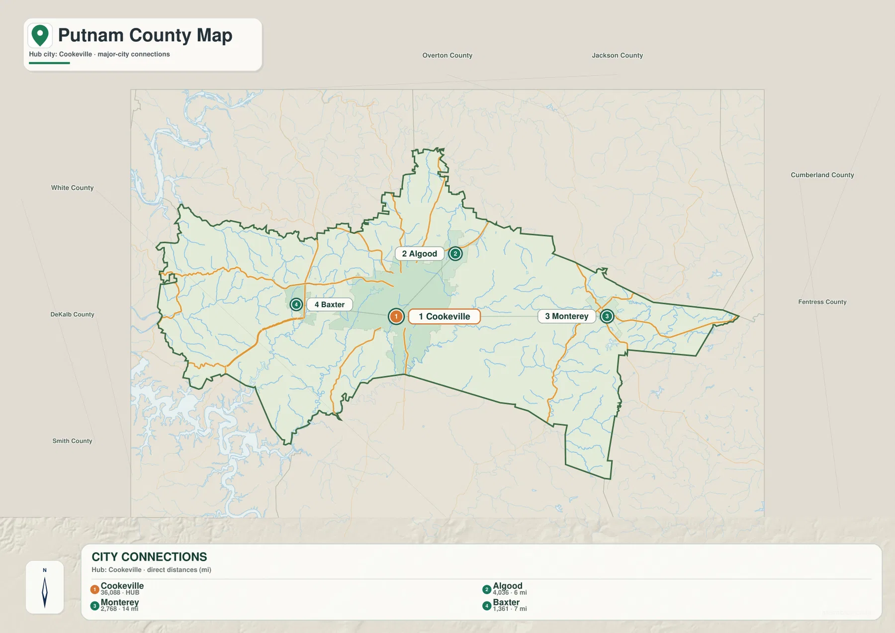
The city sheet ranks Cookeville first and labels its population as 36,088. Algood is second at 4,036 and is shown about 6 miles from Cookeville in straight-line distance. Monterey is third at 2,768 and about 14 miles from the hub, while Baxter is fourth at 1,361 and about 7 miles away. These are map-based straight-line distances, not driving distances or travel times.
Algood is the closest of the three outer cities and sits just northeast of Cookeville. Baxter gives a strong western reference, while Monterey anchors the far eastern side. That arrangement is useful because it turns Cookeville into a middle point between very different parts of the county rather than simply the largest label on the page.
The city map also labels Overton, Jackson, Cumberland, Fentress, White, DeKalb, and Smith counties around the outside. Those neighboring names help explain why Monterey is close to the eastern edge and Baxter is nearer the west. Cookeville is farther from the outer boundary and therefore works well as a stable reference for comparing roads, settlement direction, and the transition from lower western terrain to higher eastern ground.
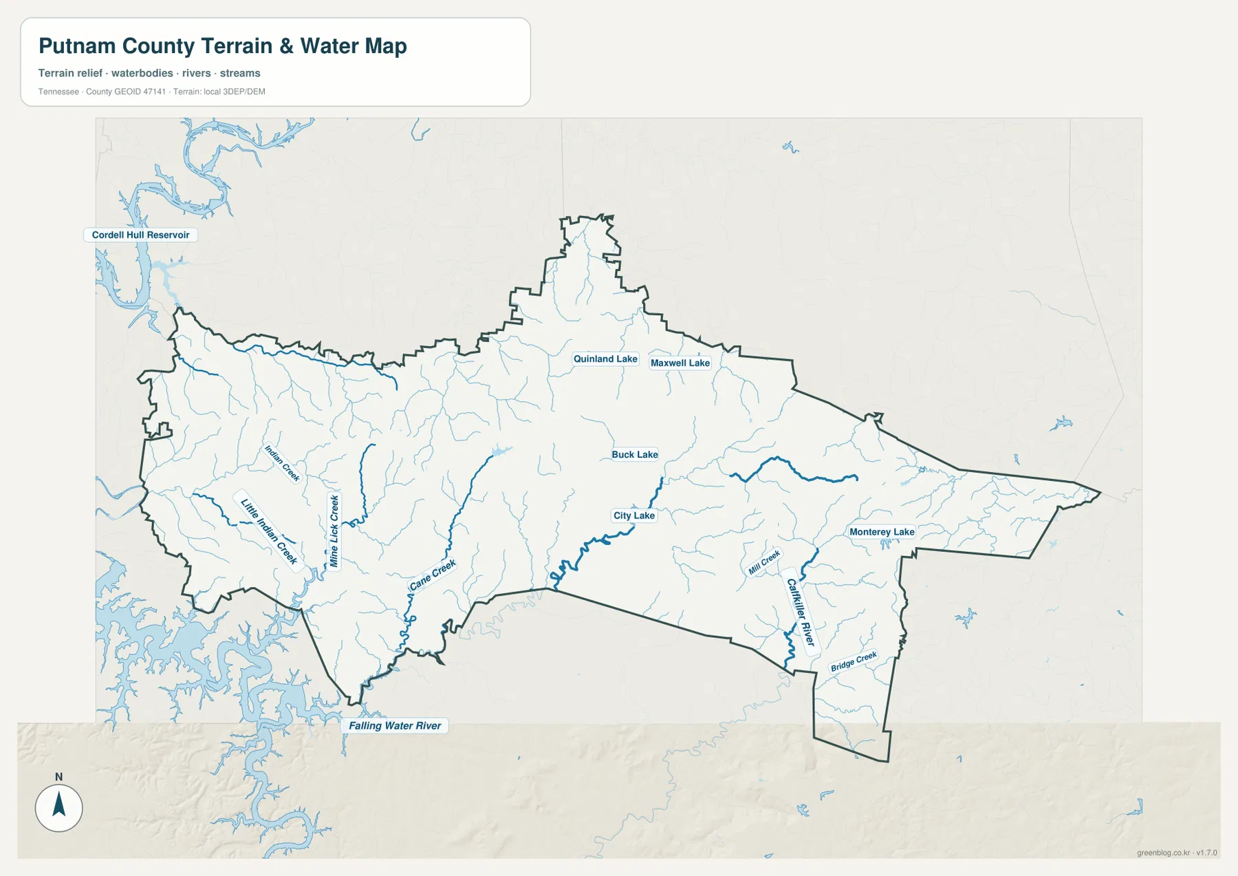
Falling Water River, creek valleys, and small lakes divide the landscape
Falling Water River is one of the easiest large water features to locate because it is labeled near the southern boundary. Across the western half, Little Indian Creek, Mine Lick Creek, and Cane Creek occupy separate valleys and receive many shorter tributaries. Cordell Hull Reservoir appears outside the northwestern edge of the county map and provides a strong regional water reference for the western side.
The central part of the water map includes City Lake, with Buck Lake farther northeast. Quinland Lake and Maxwell Lake sit in the northern half, adding smaller water references away from the large river valleys. Monterey Lake appears in the east near Monterey, and Mill Creek is labeled in the same general area. These features make it possible to compare the city map with the drainage map without relying on a broad river name that is not actually printed inside the county.
Calfkiller River and Bridge Creek are visible toward the southeastern edge. Their valleys are surrounded by much stronger relief than many of the western tributaries. Comparing the lower western creek system with the southeastern drainage shows that water does not cross Putnam County through one broad flat basin. Instead, streams occupy many distinct valleys, and the shape of those valleys changes as the terrain rises eastward.
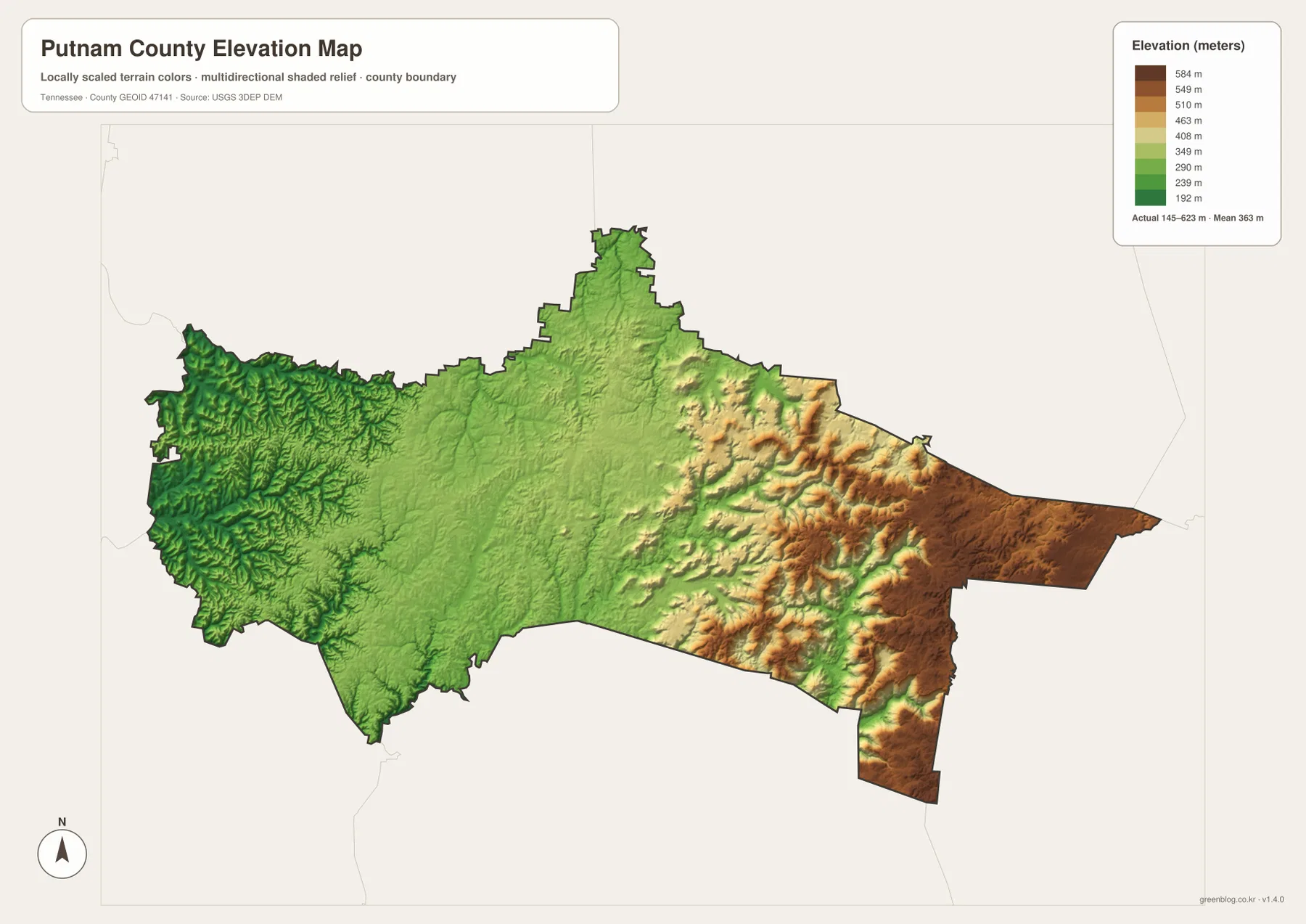
Elevation changes from about 145 to 623 meters across the county
The elevation sheet lists an actual range of about 145 to 623 meters, with a mean near 363 meters. The deepest green terrain is concentrated in western stream valleys and parts of the southwest. Cookeville occupies a broader, more moderate central surface. East of the city, yellow, tan, and brown relief becomes increasingly common as ridges rise toward the Monterey side of the county.
Monterey lies in the broadest high-elevation part of the county. Narrow green valleys cut into that high ground, so the eastern side is not a single flat plateau. The southeastern extension shows the same pattern of high ridges separated by lower drainage corridors. Those ridges help explain why roads curve more often and why streams follow narrow, twisting routes in the east.
The west is lower overall but still heavily dissected by streams. Many small valleys cut into the terrain and leave short ridges between them. For a quick county-scale comparison, the clearest sequence is the lower western drainage country, the broader Cookeville area in the middle, and the high eastern terrain around Monterey. The elevation sheet is a relief reference, not a survey product for determining an exact elevation at a property or engineering site.
County facts that help place the maps in context
- Official name: Putnam County, Tennessee
- County seat: Cookeville
- FIPS code: 47141
- 2020 Census population: 79,854
- July 2025 population estimate: 86,612
- 2025 Gazetteer area: 401.1 square miles of land and 1.5 square miles of water
- Elevation shown on this map: about 145–623 m, mean about 363 m
The completed 2020 Census count and the July 2025 estimate are different types of population figures and should remain separate. The supplied source material shows the later estimate above the 2020 count, but that does not tell us which part of the county grew fastest. The city sheet also shows a large difference in settlement size between Cookeville and the smaller outer cities.
Putnam County was established in 1854, and Cookeville serves as the county seat. That administrative role matches the current map, where Cookeville is also the most prominent city and the point where several major road directions come together. History and present-day geography therefore reinforce the same practical map-reading choice: Cookeville is the best place to begin before moving outward to Baxter, Algood, Monterey, the water network, and the higher eastern terrain.
Choose the map that matches the question
Use the county reference map when you need the boundary, Cookeville, Algood, Baxter, Monterey, and major roads together. It is the clearest choice for a general county overview or for explaining how I-40 and other routes connect the main settlements. The city sheet is better when the main task is to compare settlement size, direction, and the straight-line distance from Cookeville to the other ranked cities.
The water sheet is more useful when the question involves Falling Water River, the western creeks, City Lake, Buck Lake, Monterey Lake, or the southeastern drainage. The elevation map is the best choice for explaining the strong rise toward the east. Viewing the water and elevation maps together is especially helpful because the lower stream corridors line up with many of the green valleys on the relief map.
The downloadable high-resolution JPGs can be printed at A3 size when the original proportions are preserved. Keep an untouched copy if you plan to add arrows, route notes, or labels for a class or presentation. These are static reference maps rather than live products for road closures, flood warnings, water levels, legal parcel boundaries, or property ownership, so time-sensitive or legal questions should be checked with the responsible agency.
Frequently Asked Questions
Where are Algood, Baxter, and Monterey relative to Cookeville?
Algood is close to the northeast and is shown about 6 miles from Cookeville in straight-line distance. Baxter is west at about 7 miles, while Monterey is east at about 14 miles. These distances are useful for map orientation but should not be treated as road mileage.
Which water features are easiest to identify on the Putnam County map?
Falling Water River is clearly labeled near the southern boundary. Little Indian Creek, Mine Lick Creek, and Cane Creek are useful western references, while City Lake and Buck Lake are in the central-northern area. Monterey Lake and Mill Creek help identify the eastern side.
What is the main elevation contrast across Putnam County?
The strongest contrast is between the lower western stream valleys and the much higher terrain around Monterey and the eastern side. The supplied map shows about 145 to 623 meters of elevation, with a mean near 363 meters. Cookeville occupies a more moderate central zone between those two ends.
Map File Information
The ZIP contains high-resolution JPG versions of the county, city, water, and elevation maps. They can be used for A3 printing, presentations, classroom material, and general location reference.
- Included Files: county, city, water, and elevation JPGs
- File Type: JPG files in one ZIP
Related Maps
- Macon County Tennessee map | Lafayette and Highland Rim
- Alamo to Gadsden: A Crockett County Tennessee Map
- Altamont, Monteagle, and Plateau Valleys — Grundy County Tennessee Map
Sources and references
- Tennessee State Library and Archives — Putnam County fact sheet
- Tennessee Department of Transportation — Putnam County road reference
- U.S. Census Bureau QuickFacts — Putnam County, Tennessee
- U.S. Census Bureau TIGER/Line boundary data
- USGS National Hydrography
- USGS 3D Elevation Program
Green Map creates custom-edited map images using open geographic data sources such as geoBoundaries, Natural Earth, OpenStreetMap, and government open data. These maps are edited visual materials, not raw data files, and are provided for education, documents, presentations, and graphic reference.