The Rhea County Map on this page is built around a long north-south settlement corridor and a strong west-to-east terrain contrast. Dayton, Spring City, and Graysville sit near the US 27 corridor, while the Tennessee River forms a broad water boundary along much of the east side. You can download the matching high-resolution JPG files as one ZIP for A3 printing, presentations, classroom work, or general county reference.
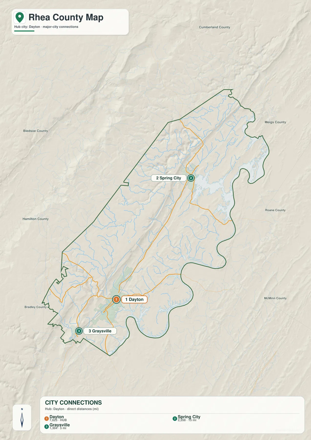
Rhea County is easier to understand when the city pattern and elevation pattern are read together. Dayton is the county seat in the south, Spring City is about 15 miles north in straight-line distance, and Graysville is about 5 miles southwest of Dayton. At the same time, the county rises toward high ridges on the west and drops toward the Tennessee River lowlands on the east, helping explain why roads and streams follow long valleys instead of crossing the county in simple straight lines.
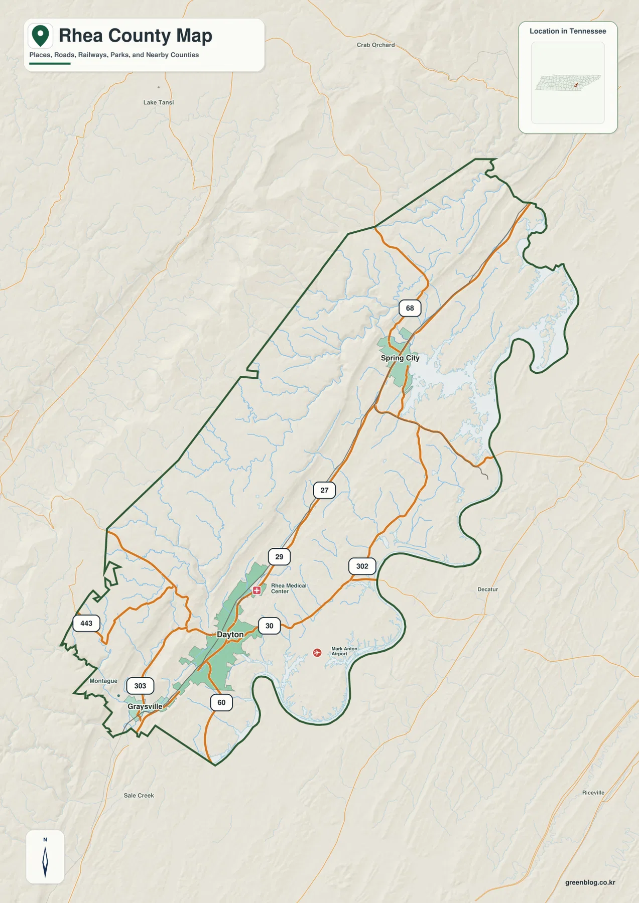
Table of Contents
US 27 links Dayton, Spring City, and Graysville along the county’s long axis
US 27 is the clearest road to follow on the reference map. It enters near Graysville in the south, passes through Dayton, and continues north toward Spring City along the same general direction as the county outline. Around Dayton, SR 30 and SR 29 add east-west connections, while SR 302 reaches toward the eastern side. SR 60, SR 303, and SR 443 provide additional routes through the southern section, and SR 68 turns northwest from the Spring City area.
Dayton has the densest concentration of labeled roads and services. Rhea Medical Center and Mark Anton Airport appear nearby, reinforcing the town’s role as the practical reference point for the southern half of the county. Graysville is close to Dayton but sits in a narrower southwestern section of the boundary. Spring City is much farther north and has its own road junctions, so the county’s three ranked cities form a line rather than one compact urban cluster.
The surrounding county labels also explain the shape of Rhea County. Higher ground toward Bledsoe and Cumberland counties lies to the west, while the eastern side faces Meigs and Roane counties across or near the Tennessee River corridor. Bradley and Hamilton counties appear beyond the southern side. The result is a long county positioned between elevated western terrain and a broad river lowland to the east.
Straight-line city distances show how far the county stretches north and south
The city sheet ranks Dayton first at 7,625 residents, Spring City second at 2,358, and Graysville third at 1,304. Spring City is shown about 15 miles from Dayton in straight-line distance, while Graysville is about 5 miles from the hub. Those values make the north-south spacing easy to compare without crowding the map with smaller settlements.
Straight-line distance is not the same as road mileage. Dayton and Spring City are connected by the US 27 corridor, but local travel is still shaped by ridges, tributary valleys, and the river-side lowlands. Graysville is geographically close to Dayton, yet its position near the narrow southwestern boundary means the county outline and surrounding terrain remain important when explaining its location.
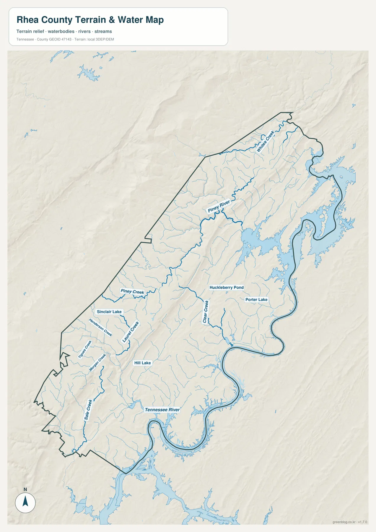
Tennessee River collects streams descending from the western ridges
The Tennessee River is the dominant water feature on the eastern and southeastern side of the county. South of Dayton it forms broad bends, and farther north its reservoir-like shoreline sends long branches toward the county boundary. The river provides a low regional corridor that contrasts sharply with the ridges on the western side.
Piney River is the strongest named tributary in the north-central part of the water map. It bends eastward from higher terrain toward the Tennessee River system. Whites Creek follows a similar direction near the northern end, while Clear Creek occupies a long central valley. Farther south, State Creek, Tiger Creek, Morgan Creek, Henderson Creek, Laurel Creek, and Piney Creek mark separate drainage valleys. The names are numerous, but their shared direction from higher western ground toward lower eastern terrain makes the drainage pattern easy to recognize.
Several smaller water bodies add useful local reference points. Sinclair Lake is shown in the west-central area, Hill Lake lies farther south, and Huckleberry Pond and Porter Lake appear closer to the center and east-central side. These features help distinguish short local valleys from the much larger Tennessee River corridor. The water sheet is designed for geographic reference rather than live water levels, flood forecasting, or navigation.
Elevation drops from western ridges toward the Tennessee River lowlands
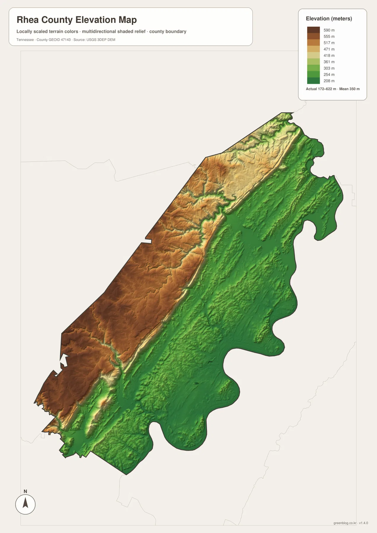
The supplied elevation map lists an actual range of about 172 to 622 meters, with a mean near 350 meters. Dark green terrain covers much of the eastern half and the Tennessee River corridor, while tan and brown ridges dominate the western side. A narrower band of higher ground also runs through the county interior, separating several long valleys.
Dayton and Spring City sit in comparatively low north-south terrain, and US 27 follows the same broad corridor. Moving west from the towns, elevation rises quickly into stronger ridge relief. Piney River and the smaller tributaries cut through that higher ground before descending east. This relationship explains why a route that looks short on a county outline may still bend through valleys rather than taking a direct path over the ridges.
The northern section contains a tighter mix of ridges and narrow stream valleys, while the eastern projections are largely lower green terrain. Around Graysville in the south, short ridges and low corridors alternate over small distances. The elevation sheet is a county-scale relief reference, not survey-grade elevation for a specific parcel or engineering site.
County facts that add context to the map
- Official name: Rhea County, Tennessee
- County seat: Dayton
- FIPS code: 47143
- 2020 Census population: 32,870
- July 2025 population estimate: 34,844
- Area: 315.5 square miles of land and 21.0 square miles of water
- Elevation shown on this map: about 172–622 m, mean about 350 m
The 2020 Census count and the July 2025 estimate are different types of population figures. The estimate is higher in the supplied source material, but it should remain labeled as an estimate rather than replacing the completed census count. Land and water totals cover the entire county, including Dayton, rural valleys, western ridges, and the large river corridor, so countywide averages do not describe every community equally.
Tennessee State Library and Archives material provides county-history and administrative background, while the modern map shows Dayton as the most useful present-day reference because roads and services concentrate there. For this page, the historical material is used only to support the county context; the main explanation remains tied to the visible road, water, city, and elevation patterns supplied in the map package.
Choose the map according to the feature you need
The county reference map is the best starting point when you need Dayton, Spring City, Graysville, the boundary, and the main roads on one page. The city sheet is cleaner for comparing the three ranked towns and their straight-line spacing. If rivers, creeks, ponds, and lakes are the priority, the water map removes much of the road emphasis and makes the Tennessee River and its tributaries easier to follow.
The elevation sheet is most useful when the question is why towns and roads occupy particular corridors. It separates the high western ridges from the lower eastern river-side terrain and shows the narrow valleys that carry tributaries toward the Tennessee River. Comparing the water and elevation maps makes the relationship between drainage and relief especially clear without turning the page into a technical GIS report.
The download ZIP contains high-resolution JPG versions of all four maps and can be printed at A3 size while preserving the original proportions. Keep an untouched copy if you plan to add routes, arrows, or notes. Current road closures, live river levels, flood warnings, legal parcel boundaries, and property ownership should be checked with the responsible agency rather than inferred from these static reference maps.
Frequently Asked Questions
How far are Spring City and Graysville from Dayton on the city map?
The city map shows Spring City about 15 miles north of Dayton and Graysville about 5 miles southwest in straight-line distance. These values are map-to-map reference distances, not turn-by-turn road mileage.
Where is the Tennessee River in Rhea County?
The Tennessee River follows much of the eastern and southeastern side of the county in broad bends. Piney River, Whites Creek, Clear Creek, and several smaller tributaries descend from the higher western terrain toward that lower river corridor.
What is the main elevation contrast across the county?
The strongest contrast is between high western ridges and the lower Tennessee River side. The elevation map shows about 172 to 622 meters, with a mean near 350 meters, while Dayton and Spring City occupy relatively low north-south terrain between stronger ridge systems.
Map File Information
The ZIP contains high-resolution JPG versions of the county, city, water, and elevation maps. They are suitable for A3 printing, presentations, classroom material, and general location reference.
- Included Files: county, city, water, and elevation JPGs
- File Type: JPG files in one ZIP
Related Maps
- Alamo to Gadsden: A Crockett County Tennessee Map
- Altamont, Monteagle, and Plateau Valleys — Grundy County Tennessee Map
- Around Chattanooga: Hamilton County Tennessee Map
Sources and references
- Tennessee State Library and Archives — Rhea County fact sheet
- Tennessee Department of Transportation — Rhea County road reference
- U.S. Census Bureau QuickFacts — Rhea County, Tennessee
- U.S. Census Bureau TIGER/Line boundary data
- USGS National Hydrography
- USGS 3D Elevation Program
Green Map creates custom-edited map images using open geographic data sources such as geoBoundaries, Natural Earth, OpenStreetMap, and government open data. These maps are edited visual materials, not raw data files, and are provided for education, documents, presentations, and graphic reference.