You can download the Roane County Tennessee Map files on this page as one ZIP containing high-resolution JPG versions of the county, city, water, and elevation views. Kingston is the central reference, with Harriman and Rockwood extending westward and Oliver Springs marking the northeastern side. The map set becomes especially useful when those towns are compared with Watts Bar Lake, Clinch River, Emory River, and the long ridges that cross the county.
Roane County is shaped as much by water as by roads. I-40 and US 70 cross the Kingston area, US 27 and SR 61 connect the northwestern cities, and SR 58 runs south through reservoir country. Between those routes are broad lake arms, river channels, and narrow valleys. Reading the road and water maps together makes the county much easier to understand than treating the highway network as lines on an empty boundary.
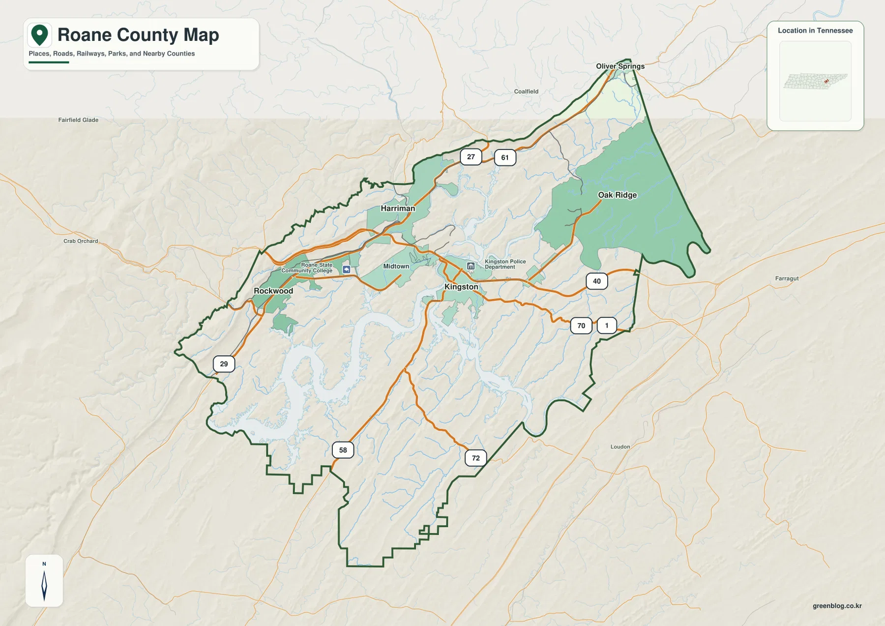
Table of Contents
Kingston links a compact group of cities across the reservoir valleys
Kingston sits slightly east of the county’s center and provides the cleanest starting point for road orientation. I-40 passes just to the north, while US 70 and SR 1 run through the Kingston area. SR 58 heads south between long water inlets, and SR 72 reaches the southeastern boundary. To the northwest, US 27 and SR 61 connect toward Harriman and Oliver Springs, while SR 29 helps locate the Rockwood side.
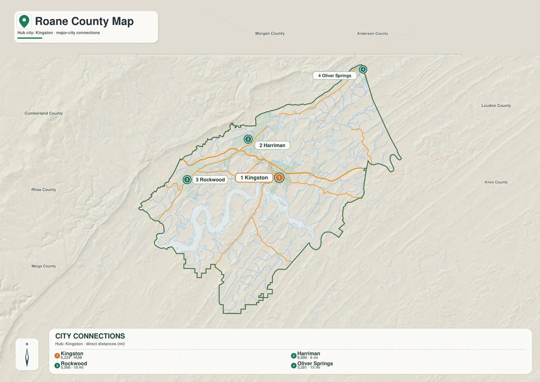
The city-connection map ranks Kingston first at 6,224 people. Harriman is second at 6,090 and is shown about 6 miles away in straight-line distance. Rockwood is third at 5,566, roughly 10 miles from Kingston, and Oliver Springs is fourth at 3,281, about 15 miles away. These are short distances, but the large amount of water between some parts of the county means that actual road routes depend strongly on bridges and valley crossings.
Harriman and Rockwood provide the strongest western references. Oliver Springs sits near the northeastern edge and helps orient the map toward Morgan and Anderson counties. Kingston remains the administrative and transportation anchor between them. Instead of reading the four city labels as a simple ranking, it is more useful to compare which side of the Clinch, Emory, and Watts Bar waters each place occupies.
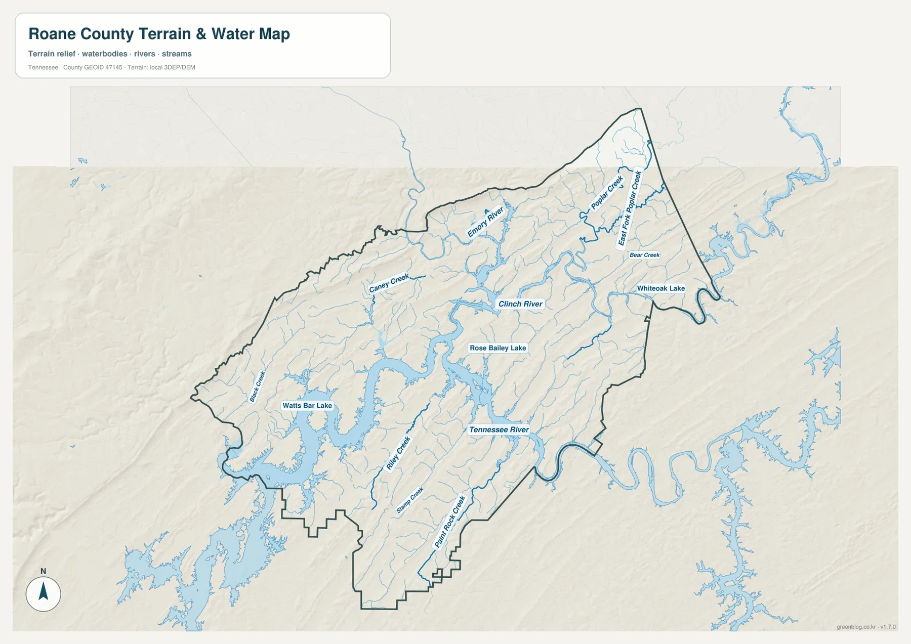
Watts Bar Lake, Clinch River, and Emory River divide the county into water corridors
Watts Bar Lake dominates the southwestern half of the water map. Its shoreline branches far into former stream valleys, creating long narrow arms rather than one simple lake edge. Blair Creek, Riley Creek, and Stamp Creek enter this reservoir country from different directions. The result is a landscape where places that appear close on a small-scale map may sit on opposite sides of a long inlet.
Clinch River forms the major central and northern water corridor. Emory River approaches from the northwest near Harriman and joins the broader Clinch system, while Caney Creek enters from the northwestern hills. Rose Bailey Lake is labeled near the central water network. The combination of these channels explains why road crossings and city connections cluster at selected points rather than occurring evenly along the river.
The northeastern side has its own group of named waters. Poplar Creek and East Fork Poplar Creek extend toward the Oak Ridge side, Bear Creek lies nearby, and Whiteoak Lake appears close to the eastern boundary. South of Kingston, Paint Rock Creek runs through a long valley toward the Tennessee River. The Tennessee River itself curves along the southeastern side, so Roane County is better understood as a meeting place of several large waterways than as a county centered on a single reservoir.
Elevation ranges from reservoir lowlands to ridges above 600 meters
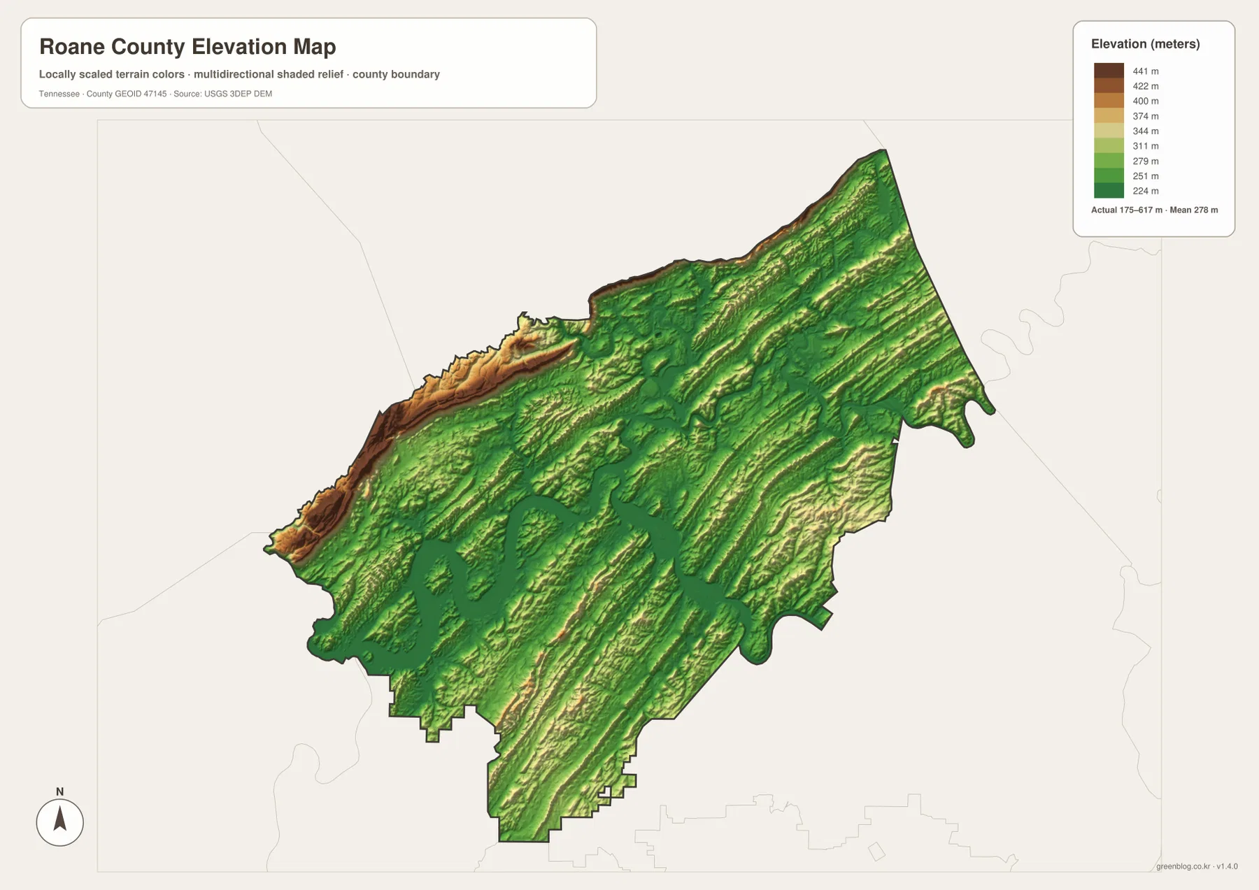
The supplied elevation map gives an actual range of about 175 to 617 meters and a mean near 278 meters. Low green terrain follows Watts Bar Lake, Clinch River, Tennessee River, and many of the branching creek valleys. Between those low corridors, long narrow ridges trend across the county and create a repeating pattern of high and low ground.
The most obvious high ground is along the northwestern and northern margins, where tan and brown ridges rise sharply above nearby valleys. Other ridges continue diagonally across the interior. This is not a county with one mountain block on one side and a flat plain on the other. Instead, parallel ridges and low valleys alternate repeatedly, which is a defining feature of the map’s relief.
Kingston and Harriman occupy relatively low corridors influenced by the large river system, while the ground rises quickly toward some of the surrounding ridges. Rockwood also sits close to the transition between reservoir lowlands and higher western terrain. The elevation sheet is best used to compare county-scale relief and explain road shape; it is not a survey map for determining an exact elevation at a property.
County facts that add scale to the map
- Official name: Roane County, Tennessee
- County seat: Kingston
- FIPS code: 47145
- 2020 Census population: 53,404
- July 2025 population estimate: 57,395
- 2025 Gazetteer area: 360.8 square miles of land and 34.2 square miles of water
- Elevation shown on this map: about 175–617 m, mean about 278 m
The 2020 Census count and the July 2025 estimate are different kinds of population figures and should remain labeled separately. The supplied source data places the 2025 estimate above the completed 2020 count, but a countywide total does not show which communities changed. The land and water figures are also useful because 34.2 square miles of mapped water helps explain how strongly reservoirs and rivers shape the county.
Roane County was established in 1801, and Kingston is the county seat. On the modern map, that administrative center also occupies a central position in the road and river network. Harriman, Rockwood, and Oliver Springs form separate surrounding references, so the county cannot be reduced to a single urban center even though Kingston is the natural place to begin reading it.
Choose the map by the feature you need to explain
The county reference map works best when you need Kingston, the surrounding cities, the boundary, and major routes on one page. It is useful for showing how I-40, US 70, US 27, SR 58, and other routes connect different parts of Roane County. The city sheet removes much of the extra detail and makes the Kingston-to-Harriman, Rockwood, and Oliver Springs relationships easier to present.
Use the water map when the important question is how Watts Bar Lake, Clinch River, Emory River, and Tennessee River fit together. The elevation view is more useful when you need to explain why those waterways occupy long low corridors between ridges. Looking at the water and elevation sheets side by side gives the clearest picture of how reservoir arms, river valleys, and high ground divide the county.
The downloadable ZIP contains high-resolution JPG versions of the map set and is designed for A3 output while preserving the original proportions. Keep an untouched original if you plan to add arrows, labels, or route notes to a copy. These are static reference maps, so current road closures, flood warnings, reservoir levels, boating conditions, parcel boundaries, and property ownership should be checked with the responsible agency.
Frequently Asked Questions
How far is Harriman from Kingston on the city map?
Harriman is shown about 6 miles from Kingston in straight-line distance. The two cities are close, but the Clinch and Emory river system and the location of major roads affect actual travel, so the straight-line figure should be used only for map comparison.
Where is Watts Bar Lake most prominent in Roane County?
The largest and most branched Watts Bar Lake water surface appears across the southwestern and south-central parts of the county. Long inlets extend toward the Kingston and Rockwood sides, with tributaries such as Blair Creek, Riley Creek, and Stamp Creek entering the reservoir system.
What stands out on the Roane County elevation map?
The clearest contrast is between low green river and reservoir valleys and the higher tan and brown ridges along the northwestern and northern sides. The displayed elevation range is about 175 to 617 meters, with a mean near 278 meters, and long ridges repeat diagonally across the county.
Map File Information
The ZIP contains high-resolution JPG versions of the county, city, water, and elevation maps. They are suitable for A3 printing, presentations, classroom material, and general county reference.
- Included Files: county, city, water, and elevation JPGs
- File Type: JPG files in one ZIP
Related Maps
- Alamo to Gadsden: A Crockett County Tennessee Map
- Altamont, Monteagle, and Plateau Valleys — Grundy County Tennessee Map
- Around Chattanooga: Hamilton County Tennessee Map
Sources and references
- Tennessee State Library and Archives — Roane County fact sheet
- Tennessee Department of Transportation — Roane County road reference
- U.S. Census Bureau QuickFacts — Roane County, Tennessee
- U.S. Census Bureau TIGER/Line boundary data
- USGS National Hydrography
- USGS 3D Elevation Program
Green Map creates custom-edited map images using open geographic data sources such as geoBoundaries, Natural Earth, OpenStreetMap, and government open data. These maps are edited visual materials, not raw data files, and are provided for education, documents, presentations, and graphic reference.