You can download high-resolution JPG maps of Fall River County, South Dakota, from this page in one ZIP file, including the supplied county, city-connections, terrain-and-water, and elevation views. The maps cover a large southwestern county where Hot Springs is the easiest orientation point, Edgemont lies far to the west, and Oelrichs sits to the southeast. Between them are the Cheyenne River, Angostura Reservoir, a network of creeks, and a strong change in relief from rugged northern ground to lower terrain toward the east and southeast.
The wide spacing of the mapped towns is not just a visual impression. U.S. Census Bureau QuickFacts lists 6,973 residents in the 2020 Census, 1,739.89 square miles of land, and a density of 4.0 people per square mile. On a county-scale map, that translates into long rural stretches between the main named places. Hot Springs has the densest cluster of roads and labels, while Edgemont and Oelrichs serve as distant western and southeastern reference points rather than parts of one continuous urban corridor.
A useful way to understand the set is to keep the same landmarks in view as the subject changes. Locate Hot Springs first, then place Edgemont to the west and Oelrichs to the southeast. Next find Angostura Reservoir southeast of Hot Springs and follow the Cheyenne River across the water map. The elevation view then adds the final piece: high, broken ground dominates much of the north and northwest, while broader low areas appear toward the east. Using the same locations across the maps is more informative than treating each image as a separate product.
Table of Contents
Roads radiate from Hot Springs toward Edgemont, Angostura, and the county edges
Hot Springs is the most practical starting point on the county reference map. It sits near the north-central part of Fall River County, where several numbered routes meet or pass nearby. U.S. 18 and U.S. 385 are especially prominent, while South Dakota highways 79 and 89 help define the road pattern around the city. From there, the map opens west toward Edgemont and southeast toward Angostura. South Dakota 71 and U.S. 385 continue toward the southern and southeastern edges, emphasizing how far the road network has to stretch across the county.
Smaller labels make the broad geography easier to place. Maverick Junction lies east of Hot Springs, Oral and Smithwick are farther across the eastern half, and Provo appears in the west. Buffalo Gap is shown beyond the northern boundary and Ardmore beyond the southern edge, so both work as outside reference points. The map is therefore useful for understanding direction and county-wide relationships, even though it is not intended to replace a street map, navigation app, or parcel-level road record.
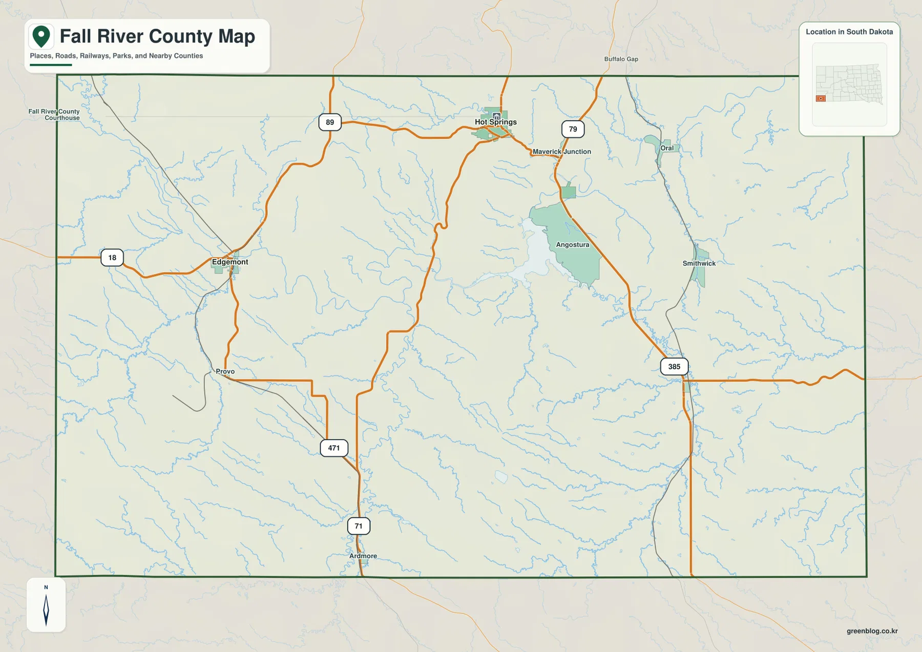
The road map also helps connect the later views. Angostura Reservoir is visible southeast of Hot Springs, so it can be carried directly into the water map. Edgemont gives the west side a clear reference point, while Oral and Smithwick help establish how far the county extends east of Hot Springs. Once those positions are familiar, a shaded-relief map with fewer road labels is much easier to interpret because the main places already have a mental location.
The Hot Springs–Edgemont–Oelrichs triangle shows how widely the towns are separated
The city-connections map removes most of the smaller detail and reduces the county to three principal points. Hot Springs is the northern hub, Edgemont is west, and Oelrichs is southeast. Their arrangement forms a broad triangle rather than an east–west line. The labels show approximately 20 miles from Hot Springs to Edgemont and 21 miles from Hot Springs to Oelrichs, but those measurements are straight-line distances between the mapped points, not mileage along the highway network.
That distinction is important in a county with uneven terrain and relatively sparse roads. Two towns can appear nearly equal in direct distance from Hot Springs while requiring different driving routes. The connection map should therefore be used to compare direction and spacing, not to estimate travel time. It is particularly helpful for showing that Hot Springs is north of the other two towns rather than sitting exactly between them.
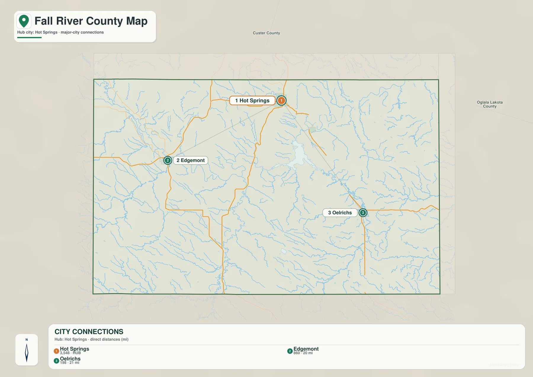
Comparing the simplified city view with the reference map adds practical context. Edgemont belongs to the western road network, Oelrichs lies near the U.S. 385 corridor in the southeast, and Hot Springs remains a northern anchor. Angostura Reservoir falls southeast of Hot Springs and north of Oelrichs, which becomes useful when the focus shifts from roads to water. This is why the three-town arrangement is more than a distance graphic: it provides a simple frame for the rest of the county.
Cheyenne River and Angostura Reservoir tie the western and central water network together
On the terrain-and-water map, the Cheyenne River is the most prominent named watercourse. It enters from the west and continues toward Angostura Reservoir, creating an obvious line across the middle of the county. Once the reservoir is located, many smaller features are easier to sort out. Fall River appears to the northeast, Beaver Creek is labeled in the northwest, and Cottonwood Creek, Coal Creek, Duck Creek, and Hat Creek cross southern and southwestern areas. Sand Creek and Horsehead Creek help define the eastern drainage pattern.
Angostura Reservoir is especially useful because it appears clearly in more than one supplied map. South Dakota Game, Fish and Parks describes the reservoir as being formed by a dam across the Cheyenne River and places the recreation area about 10 miles southeast of Hot Springs. That description matches the map relationship: Hot Springs lies to the northwest of the reservoir, the Cheyenne River approaches from the west, and a web of smaller drainage lines surrounds the broader valley system.
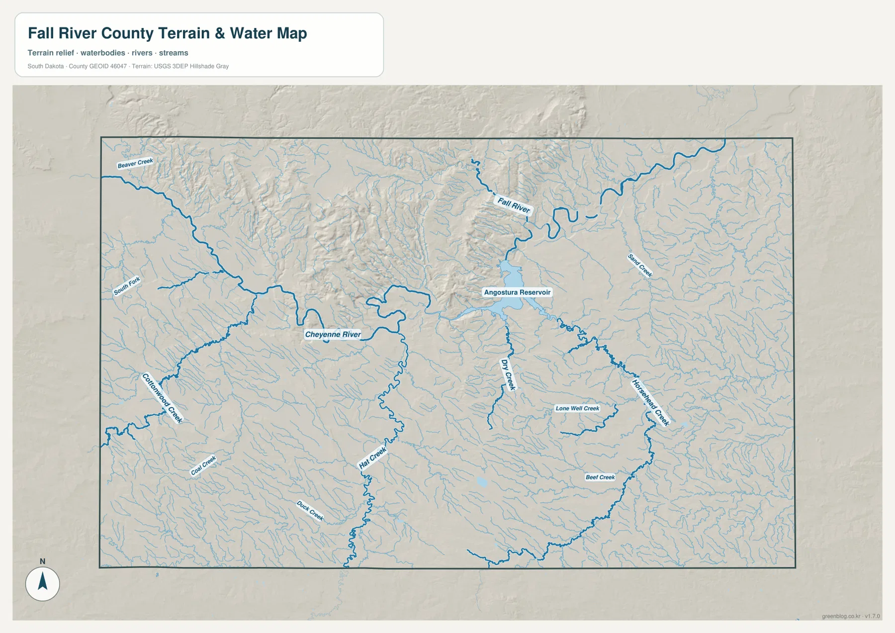
This view is a geographic reference rather than a flood-hazard map. It shows where named rivers, creeks, and the reservoir are located against a shaded terrain background, but it does not provide flood probability, seasonal discharge, water depth, water quality, or legal water boundaries. Those questions require current agency datasets designed for the specific purpose. For general orientation, the supplied map is strongest when used to relate water features to Hot Springs, Angostura Reservoir, and the major terrain zones.
Elevation rises sharply across the northern ridges and falls toward the eastern lowlands
The elevation map changes the emphasis again. Brown and dark tan shades cover much of the north and northwest, where narrow ridges and deeply cut terrain create a rough appearance. Green shades become more extensive toward the east and southeast, indicating lower ground. The Angostura Reservoir area also lies below the highest northern terrain, so the water and elevation maps reinforce one another: the reservoir and major river valley occupy lower ground than the most rugged northern uplands.
The legend gives an actual elevation range of about 865 to 1,471 meters, with a mean near 1,093 meters. A spread of more than 600 meters is large enough to explain why Fall River County cannot be summarized as uniformly flat. The strongest concentration of high terrain is in the north and northwest, although elevated areas also appear in the southwest. The east is generally lower, making the broad contrast between northern high country and eastern lowlands more useful than assuming the county slopes perfectly in a single direction.
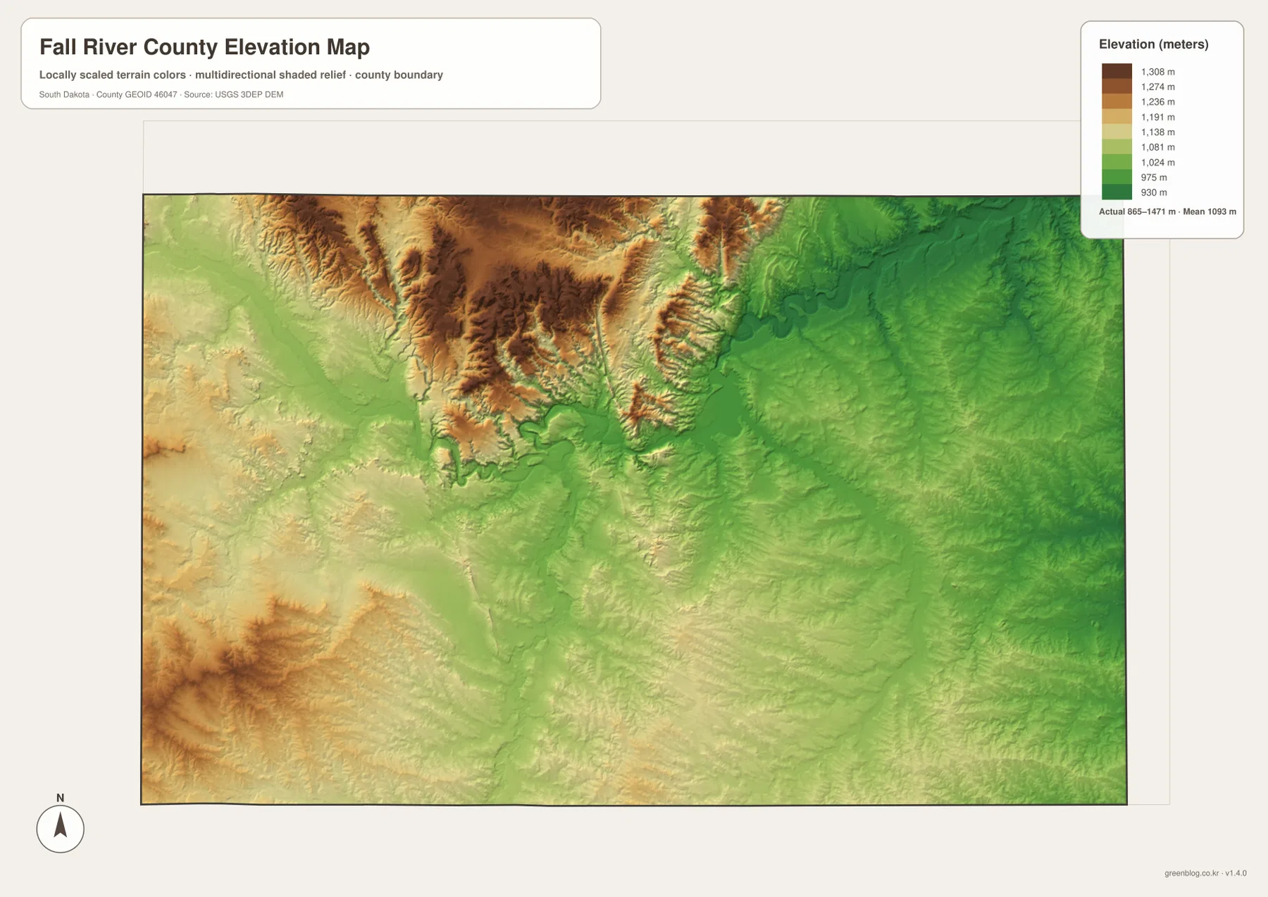
The colored surface is intended for broad comparison, not survey-grade measurement. Shaded relief makes ridges and valleys easier to recognize, while the color scale summarizes elevation change across the county. An exact property elevation, construction benchmark, or engineering profile should come from the underlying USGS products or a professional survey. For this page, the elevation map is most useful for comparing Hot Springs, the high country to the north, the Cheyenne River and Angostura basin, and the lower eastern side of the county.
Using one landmark across the maps turns separate images into one county reference
Hot Springs is the easiest landmark for a first comparison. On the reference map it anchors the northern road network; on the city-connections map it becomes the hub for Edgemont and Oelrichs. Move to the water map and Angostura Reservoir appears southeast of the city, connected to the Cheyenne River. The elevation map then shows why the northern surroundings look more rugged than the reservoir basin and much of the east. The subject changes, but the geographic relationship remains the same.
Different maps are better for different questions. Use the county reference view when boundaries, road numbers, and place names matter most. Use the city-connections view for direction and straight-line spacing between the three main towns. The terrain-and-water map is the clearer choice for the Cheyenne River, Angostura Reservoir, and tributaries, while the elevation map is best for seeing the county’s high and low terrain at a glance. The limitations are equally important: straight-line city mileage is not driving mileage, the water view is not a flood map, and the elevation view is not a land survey.
The on-page WebP images are sized for quick viewing. If you need a larger source for printing, classroom use, a presentation, or side-by-side comparison, the download box below provides the matching high-resolution JPG originals at 3638 × 2572 pixels each. The four supplied files are grouped in one ZIP so they can be saved together without relying on screenshots from the article.
Frequently Asked Questions
Are the Hot Springs–Edgemont and Hot Springs–Oelrichs distances driving distances?
No. The city-connections map shows straight-line distances between the mapped points: about 20 miles from Hot Springs to Edgemont and about 21 miles from Hot Springs to Oelrichs. Driving distance can be longer because actual travel follows the available highway network and terrain rather than a direct line.
What is the easiest water feature to use for orientation in Fall River County?
Angostura Reservoir is the clearest landmark because it is easy to recognize southeast of Hot Springs and it connects directly with the Cheyenne River on the terrain-and-water map. Once the reservoir is located, Fall River, Beaver Creek, Hat Creek, Sand Creek, and other tributaries are easier to place around it.
What does the 865–1,471 meter elevation range tell me?
It shows that the county has substantial relief, with much of the north and northwest higher than the broad eastern and southeastern lowlands. The range is useful for county-scale comparison, but it is not precise enough for property surveys, construction design, or engineering measurements. Those tasks should use the underlying elevation data or professional field measurements.
Map File Information
The ZIP file contains high-resolution JPG originals of the Fall River County reference map, city-connections map, terrain-and-water map, and elevation map.
- Included Files: 4 JPG maps
- Printable Size: 3638 × 2572 px each
Related Maps
Sources and references
The article follows the supplied Fall River County maps and the public agency references below. For legal boundaries, engineering, flood analysis, or other precision work, consult the current source datasets rather than relying on this general-purpose county map page.
- U.S. Census Bureau QuickFacts – Fall River County, South Dakota – population, land area, and density reference
- Fall River County official website – official county information
- South Dakota Game, Fish and Parks – Angostura Recreation Area – Angostura Reservoir location and recreation-area reference
- U.S. Census Bureau TIGER/Line Shapefiles – boundary and road reference
- USGS National Hydrography – national water-feature reference
- USGS 3D Elevation Program – elevation-data reference
Green Map creates custom-edited map images using open geographic data sources such as geoBoundaries, Natural Earth, OpenStreetMap, and government open data.
These maps are edited visual materials, not raw data files, and are provided for education, documents, presentations, and graphic reference.