You can download the high-resolution JPG versions of all four Edmunds County maps on this page together in one ZIP file for printing, classroom use, presentations, or side-by-side comparison. The set covers county roads and boundaries, the distribution of the principal communities, named creeks and lakes, and elevation across the county. Edmunds County stretches a long way from west to east in north-central South Dakota, and U.S. Highway 12 provides the clearest reference line: Bowdle, Roscoe, and Ipswich sit along that route, Hosmer lies to the north, and Mina appears near the eastern edge.
The wide gaps between the main towns fit the county’s rural scale. U.S. Census Bureau QuickFacts reports 3,986 residents in the 2020 Census, about 1,125.98 square miles of land, and a density of 3.5 people per square mile. On the map, that pattern appears as a handful of clear settlement anchors separated by large stretches of countryside. Ipswich is the county seat in the eastern half, Roscoe and Bowdle lie farther west along U.S. 12, and Hosmer stands apart to the north rather than forming a continuous line with the other three.
A useful way to read the page is to keep one place in mind while changing maps. Find Ipswich and U.S. 12 on the county map, compare its position with Bowdle, Roscoe, and Hosmer on the city map, then look at the same eastern half on the water and elevation maps. The eastern side contains a much more visible network of channels associated with Snake Creek, and the elevation map shows that this same part of the county is generally lower than the broad western uplands. That connection between roads, settlements, drainage, and relief is the main geographic story of Edmunds County.
Table of Contents
U.S. 12 ties the long county together from Bowdle to Ipswich
Edmunds County has a comparatively simple outline, with long north and south boundaries and shorter east and west sides. The county comprehensive plan places McPherson County to the north, Brown County to the east, Faulk and Potter counties to the south, and Walworth County to the west. Because the boundary is not dominated by a winding river or an irregular mountain front, the internal transportation pattern is easy to recognize. U.S. 12 crosses the county near its middle and gives the map a strong east–west orientation.
Following U.S. 12 from west to east provides a simple sequence of places. Bowdle appears near the western side, Roscoe is farther east, and Ipswich comes next before the highway reaches the Mina area and the Brown County side. Several state highways add north–south connections. SD 47 crosses near Bowdle, SD 253 runs north toward Hosmer, SD 247 rises north from the central-western U.S. 12 corridor, and SD 45 turns south from Ipswich toward the county line.
The smaller labels are useful when a reader needs more than the four largest towns. Plainview Colony and Deerfield Colony are shown near the northern part of the county, Pembrook Colony is south of Ipswich, and Mina provides an eastern checkpoint along U.S. 12. These names make it easier to keep track of position on a map where rural roads and open land can otherwise look repetitive. They also help distinguish “east of Ipswich” from “near the county edge,” which are not the same location.
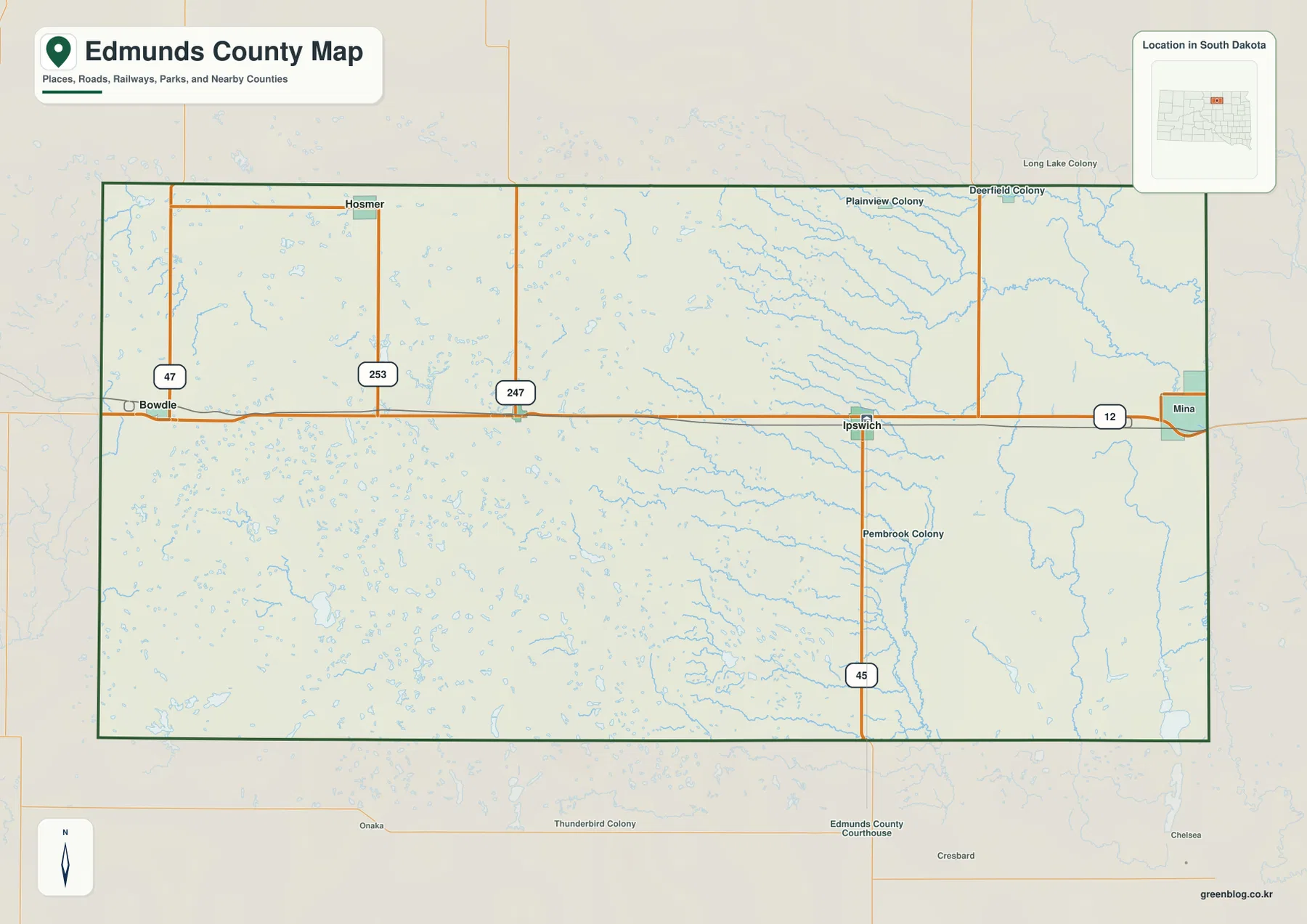
This is a county-orientation map rather than a turn-by-turn navigation product. It is most useful for questions such as which side of the county a town occupies, which major highway reaches it, and how a location relates to the neighboring counties. Once U.S. 12 and Ipswich are fixed in mind, the other maps become easier to compare because the same east–west framework can be carried over even when the roads are removed.
The principal communities form a wide row with Hosmer set to the north
The city-distribution map ranks Ipswich first, Bowdle second, Roscoe third, and Hosmer fourth. The ranking matters less than the shape created by their positions. Ipswich is in the eastern half, Roscoe lies to its west, and Bowdle is farther west near the county edge. Hosmer is the exception: it sits well north of the U.S. 12 line, so the four communities do not form a simple string of towns across the middle.
Ipswich works especially well as an orientation point because it is both the county seat and the junction of U.S. 12 with SD 45. From there, a reader can move west toward Roscoe and Bowdle or look northwest toward Hosmer. The map also names the surrounding counties outside the boundary, which prevents the settlement pattern from feeling isolated. Brown County is to the east, McPherson County is to the north, and the southern and western counties frame the rest of the long rectangle.
The blank areas between the ranked towns should not be read as empty or unused land. This map intentionally emphasizes the principal communities rather than every farm, residence, rural road, or small settlement. Its strength is scale. When Bowdle and Ipswich appear on the same page, the county’s long east–west reach is much easier to appreciate than it would be on separate local street maps.
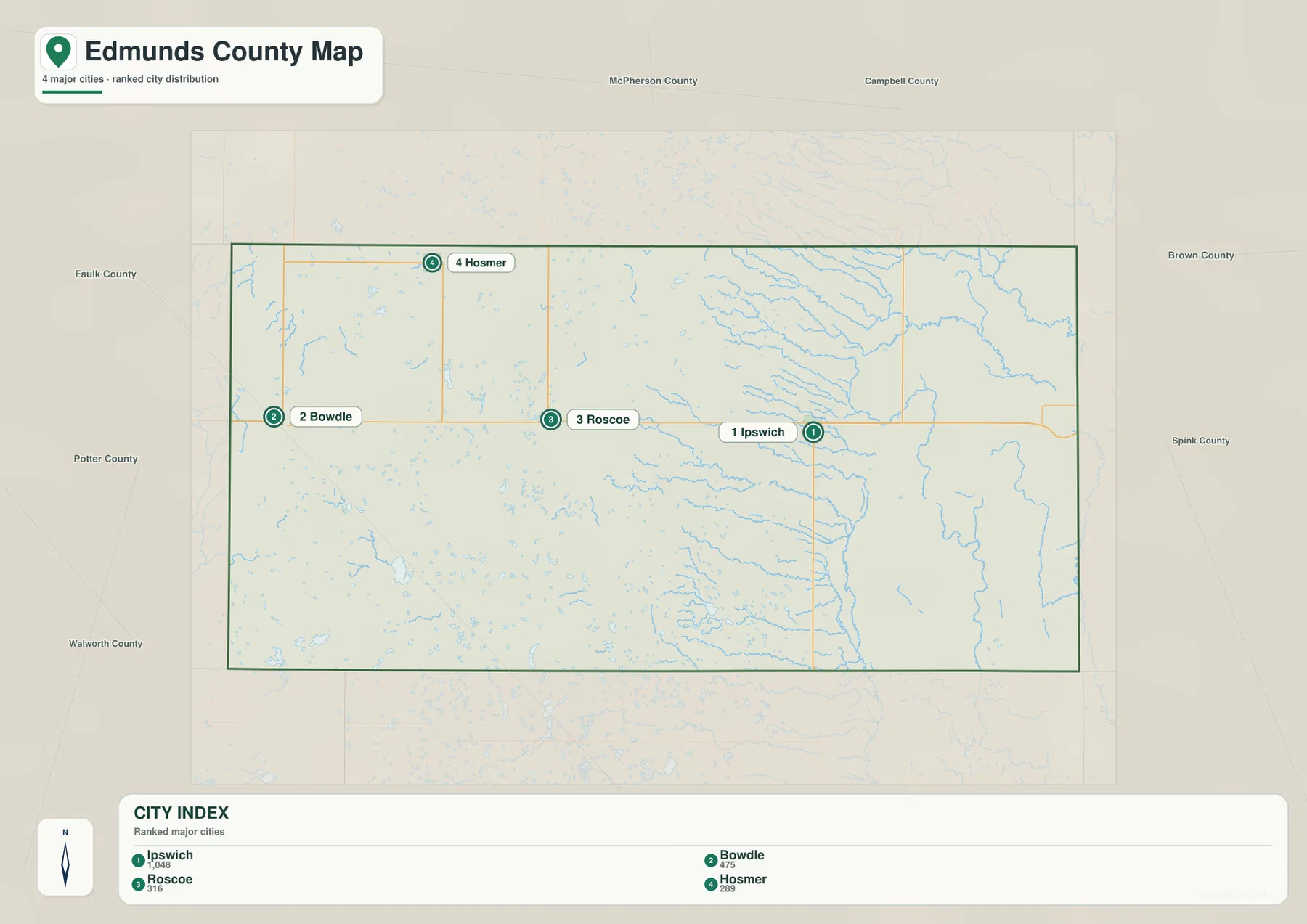
Switching back to the road map turns those dots into a memorable transportation pattern. Bowdle sits near the U.S. 12 and SD 47 crossing, Ipswich near U.S. 12 and SD 45, and Hosmer near the northern reach of SD 253. Roscoe occupies the middle part of the U.S. 12 sequence. Remembering one highway with each place is often more useful than memorizing a list of town names without direction.
Snake Creek gives the eastern half a much denser water pattern
The terrain-and-water map changes the visual emphasis from orange highway lines to blue channels. The eastern half contains far more obvious branching streams than the west. Snake Creek is labeled near the eastern and northeastern side, while North Fork Snake Creek runs through the lower part of the eastern half. Pheasants Run and Stony Run are also labeled toward the southeast, adding to the impression of a connected drainage network rather than a single isolated creek.
Named lakes provide additional reference points. Rosette Lake appears in the northern part of the eastern half, Grass Lake is near the southeast, and Alkali Lake sits near the southwestern edge. The west also contains many small blue water bodies, but they are more scattered and less dominated by long named channels. At county scale, the contrast is clear: the east is drawn with branching lines, while the west contains more isolated patches of water.
This map should not be treated as a flood map, wetland boundary, boating chart, or water-quality product. It helps locate named creeks, lakes, and the surrounding terrain, but it does not show flood probability, channel depth, seasonal flow, or legal wetland limits. Those questions require dedicated hydrologic or environmental sources. For general geography, however, the map is very effective at showing where the Snake Creek network is concentrated inside the county.
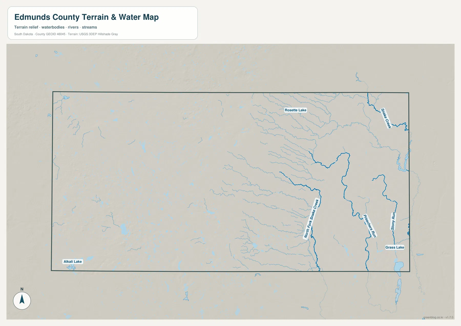
The settlement map adds useful context to this water pattern. Ipswich lies closer to the eastern part of the county where the drainage lines become more numerous, while Bowdle and Hosmer are farther west where isolated water bodies stand out more than major branching channels. The maps do not imply that these towns were placed because of the particular features shown here, but comparing them makes the physical setting of each side of Edmunds County easier to describe.
Western uplands fade into lower eastern ground across the county
The elevation map provides the clearest single picture of Edmunds County’s large-scale terrain direction. Browns and tans dominate the west, then gradually give way to pale and darker greens toward the east. The legend reports an actual mapped range of about 386 to 642 meters and a mean of about 516 meters. That is a difference of more than 250 meters between the lowest and highest mapped ground, enough to create a visible county-wide gradient even though the landscape is not mountainous.
The higher-looking terrain covers much of the west, particularly the west-central and northwestern areas. Moving toward the center, the colors become lighter, and the eastern half settles into greener, lower terrain. Narrow low corridors are visible within that eastern area. Their shapes closely resemble the stream valleys seen on the water map, especially around the Snake Creek network.
The change is gradual rather than a single dramatic escarpment. Local rises and shallow depressions occur on both sides, and the central-southern part of the county shows its own small variations. For that reason, “higher west and lower east” is best understood as a broad trend, not a rule that every western point is higher than every eastern point. The shaded relief preserves those local differences while still making the overall slope easy to see.
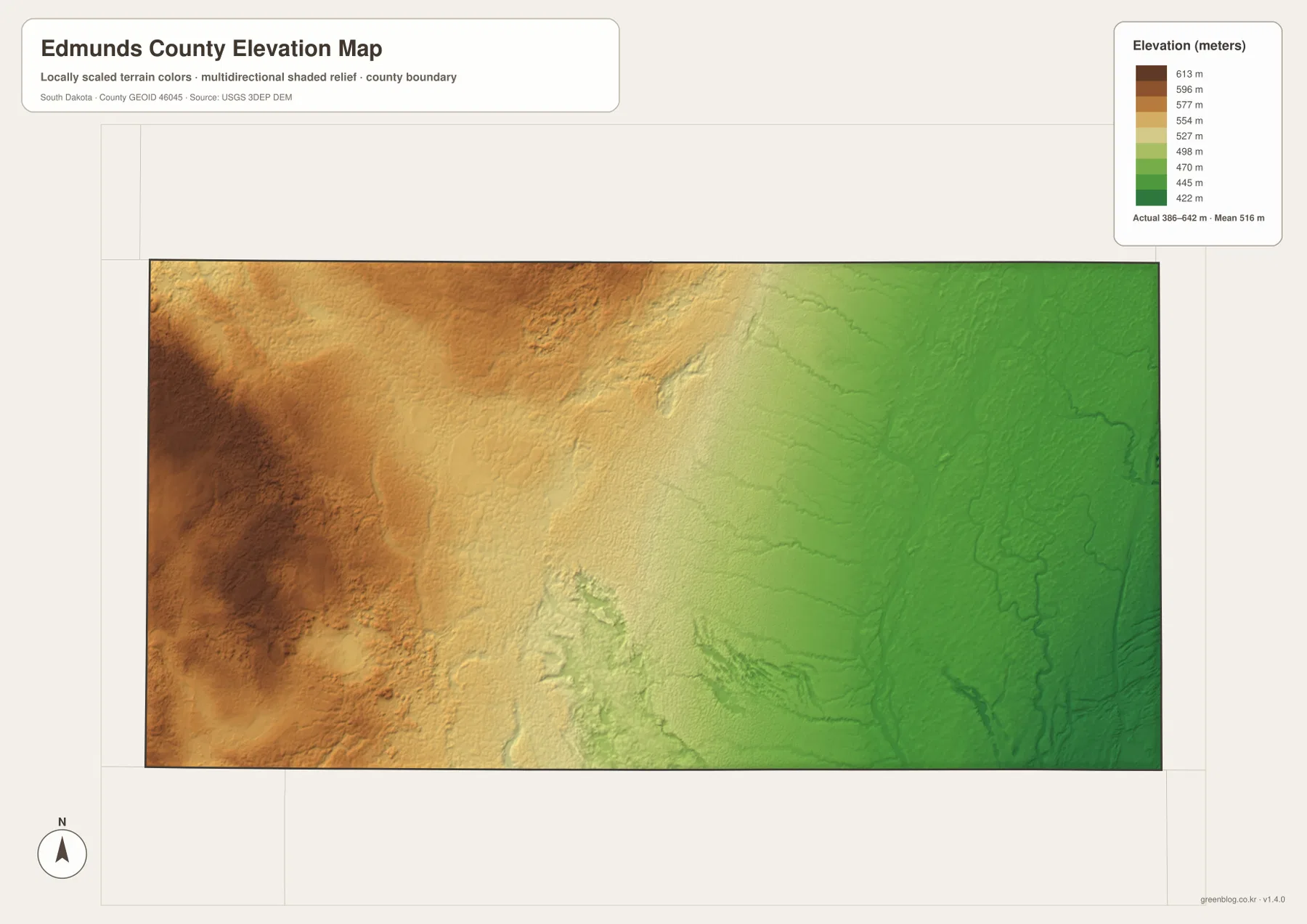
This generalized county-scale surface is useful for understanding relief, but it is not a parcel survey or an engineering dataset. A property owner, contractor, or surveyor who needs an exact site elevation should use the underlying source data or professional field measurements. On this page, the map is best used to explain how U.S. 12 crosses changing terrain and why the eastern water map contains such a distinct network of low drainage corridors.
Comparing the same place across four maps reveals the county’s structure
Ipswich is a good example of how the set works. On the county map, it is the U.S. 12 and SD 45 junction. On the city map, it is the leading settlement and a clear eastern anchor. Move to the water map and the surrounding eastern half contains many more tributary lines than the west. The elevation map then shows that this same side of the county lies on lower ground. Keeping Ipswich fixed while changing the information layer turns four separate images into one coherent geographic explanation.
Bowdle produces a different comparison. It is a western U.S. 12 town near SD 47, far from Ipswich on the settlement map, surrounded by a less continuous water pattern, and positioned in the higher brown-toned part of the elevation map. Hosmer adds the northern dimension, while Roscoe acts as an intermediate point along U.S. 12. These differences are specific enough that the maps can be used for more than a generic county outline exercise.
For quick reading on a screen, the WebP images are convenient. For printing, classroom work, presentations, or side-by-side comparison, the ZIP below contains the original JPG files at 3638 × 2572 pixels each. A reader can use only the road map, pair the water and elevation maps, or place the city map next to the county map depending on the question being studied.
Frequently Asked Questions
What is the easiest feature to use when orienting yourself in Edmunds County?
U.S. 12 is the simplest starting point because it runs across the middle of the county and links Bowdle, Roscoe, and Ipswich before continuing toward the eastern boundary. Once that line is familiar, the north–south positions of Hosmer and the state highways are easier to place, and the same east–west framework can be carried over to the water and elevation maps.
Why does the eastern half look more heavily cut by streams?
The water map labels Snake Creek, North Fork Snake Creek, Pheasants Run, Stony Run, and numerous smaller branches in the east, so the drainage lines appear much denser there. The elevation map also shows the eastern half as generally lower, with narrow low corridors that align with many of those channels. The maps provide location and terrain context, not flood frequency or seasonal flow.
Can the 386–642 meter elevation range be used for a property or construction survey?
No. That range describes the broad elevation shown across the county and is useful for comparing western high ground with lower eastern terrain. It is not precise enough for a parcel boundary, building design, drainage engineering, or construction staking. Site-specific work should use higher-resolution source data and, when necessary, professional field measurements.
Map File Information
The ZIP file contains high-resolution JPG originals of the Edmunds County boundary-and-road map, city-distribution map, terrain-and-water map, and elevation map.
- Included Files: 4 JPG maps
- Printable Size: 3638 × 2572 px each
Related Maps
Sources and references
The article is based on the supplied Edmunds County maps and the official county, Census Bureau, and U.S. Geological Survey references below. For legal, engineering, flood, or other precision work, use the original agency data rather than this general-purpose map page.
- Edmunds County, South Dakota — About – county-seat and local background
- Edmunds County Comprehensive Plan 2022 – neighboring counties, U.S. 12, state highways, and county context
- U.S. Census Bureau QuickFacts: Edmunds County – population, land area, and density reference
- U.S. Geological Survey National Hydrography – national water-feature reference
- U.S. Geological Survey 3D Elevation Program – elevation-data reference
Green Map creates custom-edited map images using open geographic data sources such as geoBoundaries, Natural Earth, OpenStreetMap, and government open data.
These maps are edited visual materials, not raw data files, and are provided for education, documents, presentations, and graphic reference.