Noxubee County is in eastern Mississippi, where Macon provides the clearest central reference for roads, communities, and county orientation. You can download the county, city, water, and elevation maps on this page together as one A3 high-resolution JPG ZIP. The files are prepared for printing, classroom use, presentations, and editing, while the sections below explain the roads, communities, rivers, lakes, and elevation shown on each map.
The main road pattern is easy to recognize before looking at the smaller details. US 45 runs north and south through Brooksville, Macon, and Shuqualak, while MS 14 crosses the county through Macon and continues toward the Alabama side. Away from the road network, the Noxubee River bends through the middle of the county toward the southeast, with a cluster of named lakes and tributaries on the western and northwestern side. The elevation map adds another layer: the southwest is noticeably higher, while much of the central and eastern county lies at lower elevations.
Table of Contents
Where Noxubee County sits in eastern Mississippi
Noxubee County reaches the Alabama state line on the east. The provided community map places Lowndes and Oktibbeha counties to the north, Winston County to the west, and Kemper County to the southwest, giving useful outside references for readers who are not familiar with this part of Mississippi. Inside the boundary, Macon is the county seat and the most useful place to start. Brooksville lies north of Macon and Shuqualak lies to the south, with all three aligned along the US 45 corridor.
| Item | Map or source value |
|---|---|
| County seat | Macon |
| FIPS code | 28103 |
| 2020 census population | 10,285 |
| July 2025 population estimate | 9,798 |
| 2025 Gazetteer land area | 695.361 sq mi |
| 2025 Gazetteer water area | 4.825 sq mi |
| Density using 2020 population and listed land area | about 14.8 people per sq mi |
| Elevation map range | about 39–195 m; mean 71 m |
The census count and the July 2025 estimate describe different dates, so they should not be treated as two measurements from the same moment. The later estimate is 487 people below the 2020 count. Combined with a land area of more than 695 square miles, those figures help explain why the mapped communities appear widely spaced and why much of the page is occupied by roads, streams, woods, fields, and lowlands rather than a continuous urban area.
Macon and the US 45 community corridor
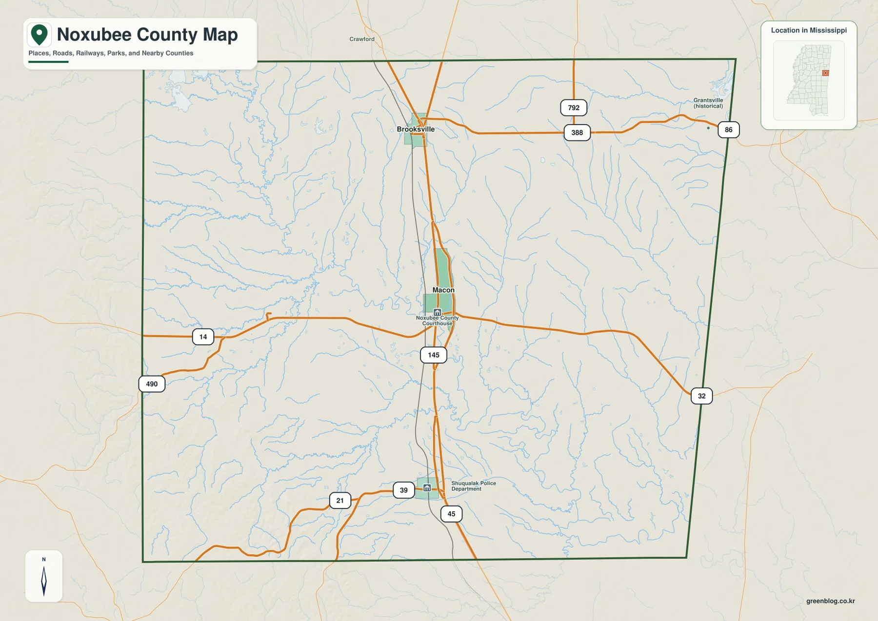
For road orientation, US 45 is the strongest line on the map. It enters from the north near Brooksville, continues through Macon, and runs south toward Shuqualak. Macon is also where MS 14 crosses from west to east, creating an obvious reference point for readers trying to understand the county without studying every secondary road. South of Macon, MS 145 follows the same general north-south part of the county, while MS 39 and MS 21 appear around the Shuqualak side.
The northeastern side includes MS 388 and route 792, and MS 32 appears along the eastern edge. These roads are useful for orientation, but the map is not intended to replace turn-by-turn navigation or a detailed local road atlas. Farm entrances, refuge roads, and minor tracks are deliberately not the focus. If the goal is to explain where one community sits relative to another, the simpler community map below removes much of that extra detail.
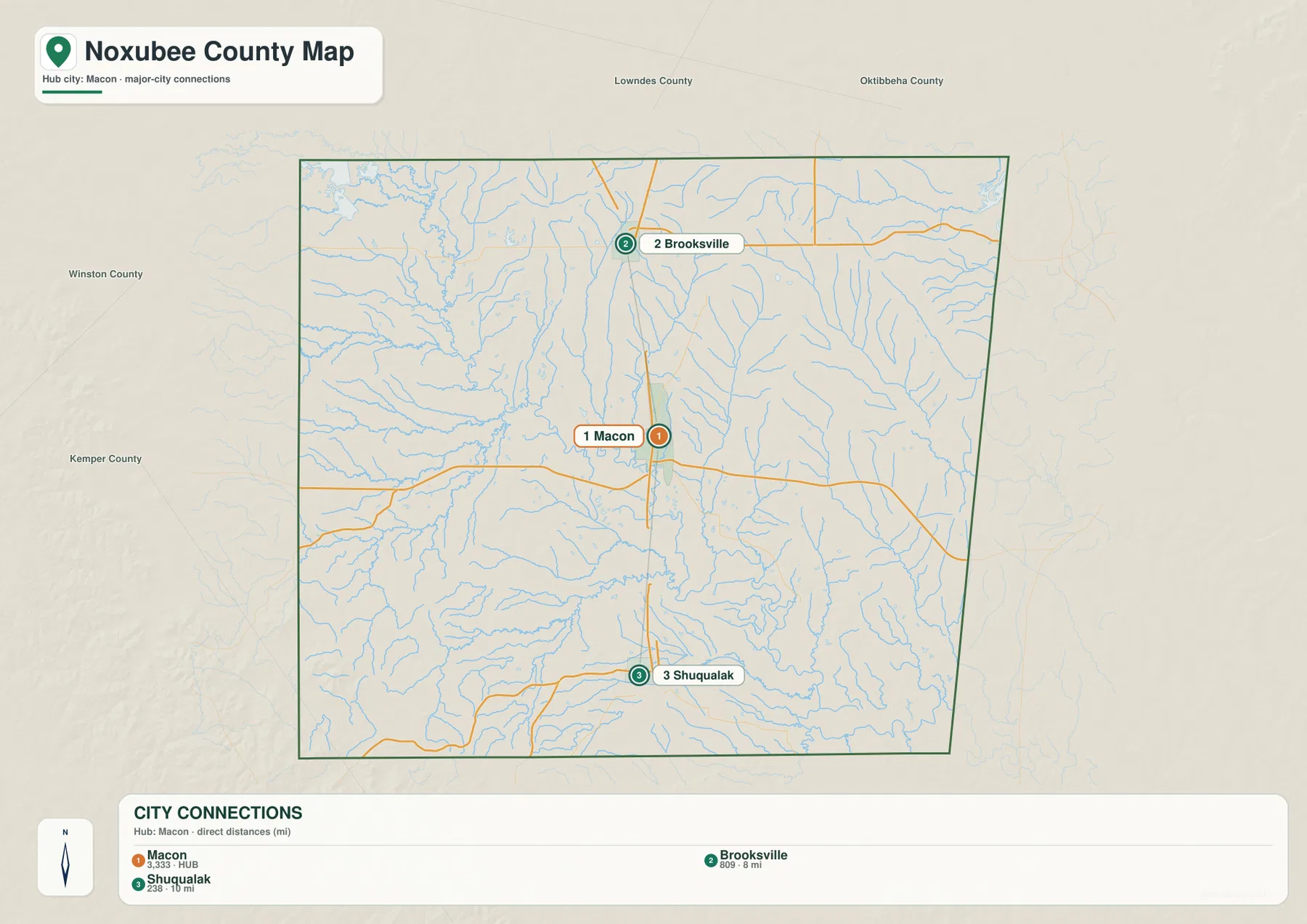
This reduced community view makes the county’s settlement pattern easier to see. Macon is marked in the center, Brooksville above it, and Shuqualak below it. The same map also labels nearby Lowndes, Oktibbeha, Winston, and Kemper counties around the outside, so it works well when a presentation or worksheet needs a simple geographic reference without the full network of streams and secondary roads. It is especially useful for explaining the north-south spacing of the three labeled communities.
The Noxubee River, western creeks, and named lakes
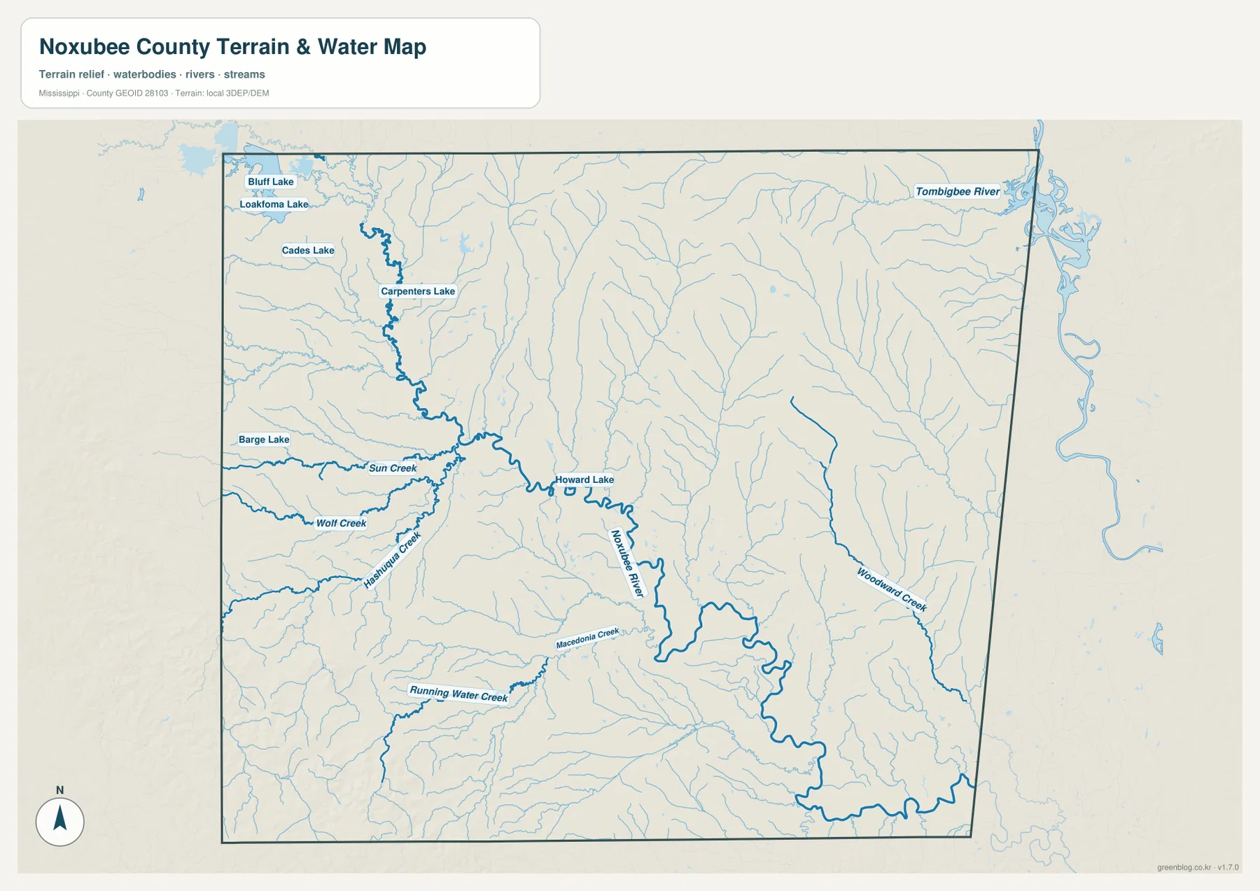
The terrain-and-water map shifts attention away from highways and toward the drainage network. The Noxubee River is the dominant feature, winding through the central part of the county and continuing toward the southeast. Several named streams feed or parallel the larger system. Sun Creek and Wolf Creek are labeled on the west, Hashuqua Creek approaches from the southwest side of the central drainage, and Macedonia Creek and Running Water Creek appear farther south. Woodward Creek is a clear eastern feature.
The northwestern corner contains the densest group of named lakes in the provided map set. Bluff Lake and Loakfoma Lake sit close together near the upper-left side, with Cades Lake and Carpenters Lake farther south. Barge Lake is marked on the western side and Howard Lake lies closer to the center. The Tombigbee River is shown outside the county’s eastern edge as a larger regional water reference, which helps place Noxubee County within the broader river landscape without implying that the entire Tombigbee channel lies inside the county.
The Sam D. Hamilton Noxubee National Wildlife Refuge is an important regional reference for this landscape, but the county maps on this page are not detailed refuge-boundary maps. The preserved source material describes the refuge as a broad management area associated with Noxubee County and neighboring lands. Readers who need exact refuge boundaries, access information, or current visitor details should use the U.S. Fish and Wildlife Service page linked in the sources section rather than treating the general county outline as a refuge boundary.
Higher ground in the southwest, lower terrain through the center
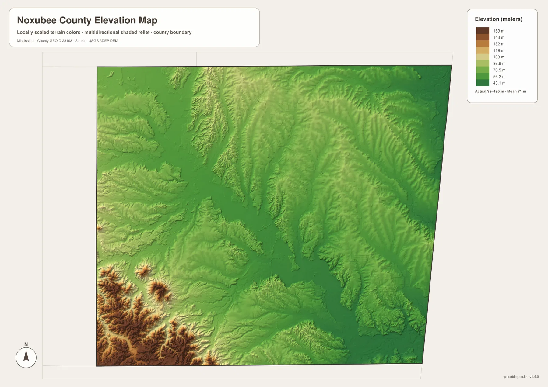
The elevation map uses a local scale rather than road labels. Its legend gives an actual range of roughly 39 to 195 meters and a mean of 71 meters. The strongest orange and brown tones are concentrated in the southwest, where a series of ridges and short valleys create the most obvious relief in the county. Moving toward the center, the colors shift into greener tones and the landscape becomes lower overall.
Much of the central and eastern county remains in the lower part of the displayed elevation range, although narrow ridges and valleys continue across the north and east. The broad lower corridor through the middle can be compared with the Noxubee River on the water map, making it easier to connect the shape of the drainage network with the surrounding terrain. The supplied elevation image therefore adds useful context that is not obvious from the road map alone: Noxubee County is not uniformly flat, even though the lower central and eastern areas occupy a large portion of the map.
County edges and nearby reference points
The eastern boundary is easy to recognize because it is also the Mississippi-Alabama state line. The other sides are better understood by combining neighboring county names with the road pattern. Lowndes and Oktibbeha are shown to the north, Winston to the west, and Kemper to the southwest. Inside the county, Macon and US 45 remain the most dependable references when moving from one edge to another.
This matters when the map is used for regional comparisons. A reader following the Brooksville side northward can relate that area to Lowndes and Oktibbeha, while roads around Shuqualak and MS 21 help orient the southern and western sides. On the east, MS 14 and MS 32 point toward the Alabama boundary. The county overview is therefore best used to establish direction, adjacency, and the relationship among towns, roads, and waterways; detailed property lines and local access routes require more specialized sources.
Which Noxubee County map should you use?
The county overview is the most useful general-purpose version because it keeps communities, major roads, streams, and the boundary on the same page. The community map is better when Macon, Brooksville, and Shuqualak need to be explained without extra detail. For rivers, creeks, and lakes, the water map makes features such as the Noxubee River and the northwestern lake group much easier to distinguish. The elevation map is the best choice when the question is about the higher southwest or the lower central and eastern terrain.
- County overview: roads, communities, streams, and the county boundary together
- Community map: a cleaner comparison of Macon, Brooksville, and Shuqualak
- Water map: the Noxubee River, tributaries, lakes, and the nearby Tombigbee reference
- Elevation map: the 39–195 m range and the contrast between the southwest and lower central terrain
The WebP versions in the article are optimized for on-page viewing. The download package contains four high-resolution A3 JPG files covering the same county, community, water, and elevation themes. That makes the ZIP more suitable for printing, inserting into reports or slides, or editing at a larger size than the browser previews.
Frequently Asked Questions
What is the easiest reference point for locating places in Noxubee County?
Start with Macon and US 45. Brooksville is north of Macon and Shuqualak is south of it along the same main corridor, while MS 14 crosses through Macon toward the eastern side of the county.
Which map shows the Noxubee River and lakes most clearly?
Use the water map. It emphasizes the Noxubee River along with named tributaries and lakes such as Bluff Lake, Loakfoma Lake, Cades Lake, Carpenters Lake, Barge Lake, and Howard Lake.
Does this page show the exact boundary of the Noxubee National Wildlife Refuge?
No. These maps are county-scale reference maps and do not provide the refuge’s detailed management boundary. For exact refuge limits and current visitor information, use the official U.S. Fish and Wildlife Service source linked below.
Map File Information
This ZIP contains four A3 high-resolution JPG maps of Noxubee County: county overview, community connections, water and terrain, and elevation.
- Included Files: County overview map, community-connections map, water-and-terrain map, and elevation map
- File Type: Four high-resolution A3 JPG files in one ZIP archive
- Intended Use: Printing, education, presentations, and map-based projects
Related Maps
Sources and data references
Population, area, road, hydrography, elevation, and refuge context were checked against the official references listed below. The maps on this page are designed for county-level orientation, so readers who need current operational details, exact protected-area boundaries, or specialized GIS data should consult the source agency directly.
- U.S. Census Bureau QuickFacts for Noxubee County
- U.S. Census Bureau Gazetteer Files
- Mississippi Department of Transportation official highway map
- USGS National Hydrography
- USGS 3D Elevation Program
- U.S. Fish and Wildlife Service — Sam D. Hamilton Noxubee National Wildlife Refuge
Green Map creates custom-edited map images using open geographic data sources such as geoBoundaries, Natural Earth, OpenStreetMap, and government open data. These maps are edited visual materials, not raw data files, and are provided for education, documents, presentations, and graphic reference.