Caldwell County lies southeast of Austin in Central Texas, with Lockhart near the center, Luling to the south, Martindale toward the west, and smaller communities such as Uhland and Mustang Ridge toward the northwest. You can download the four original high-resolution A3 JPG maps from this page together in one ZIP archive. The maps also make it easy to compare the county boundary, major roads, town spacing, Plum Creek and its tributaries, the San Marcos River, and the local elevation changes that shape the landscape.
The county is not a flat, featureless block between Austin and Interstate 10. Its mapped elevation ranges from about 93 to 223 meters, with lower corridors running through the center and south and higher ground appearing around parts of the north, northwest, and east. That relief helps explain why the water map is so useful: the creeks are not random blue lines, but parts of a drainage network that follows the lower terrain. Reading the road, city, water, and elevation views together gives a much clearer picture of Caldwell County than any single layer can provide.
Table of Contents
Lockhart at the center of a multi-direction road network
The general county map is the best place to establish orientation. Lockhart is near the middle, with the Caldwell County Sheriff’s Office marked just to the east of the city. State Highway 130 approaches from the north, while U.S. 183 continues south toward Luling. State Highway 142 runs west from Lockhart toward Martindale and San Marcos, and State Highway 21 is visible near the northwestern side. Together, these routes show why Lockhart functions as more than the county seat: it is also the point where several useful travel directions meet.
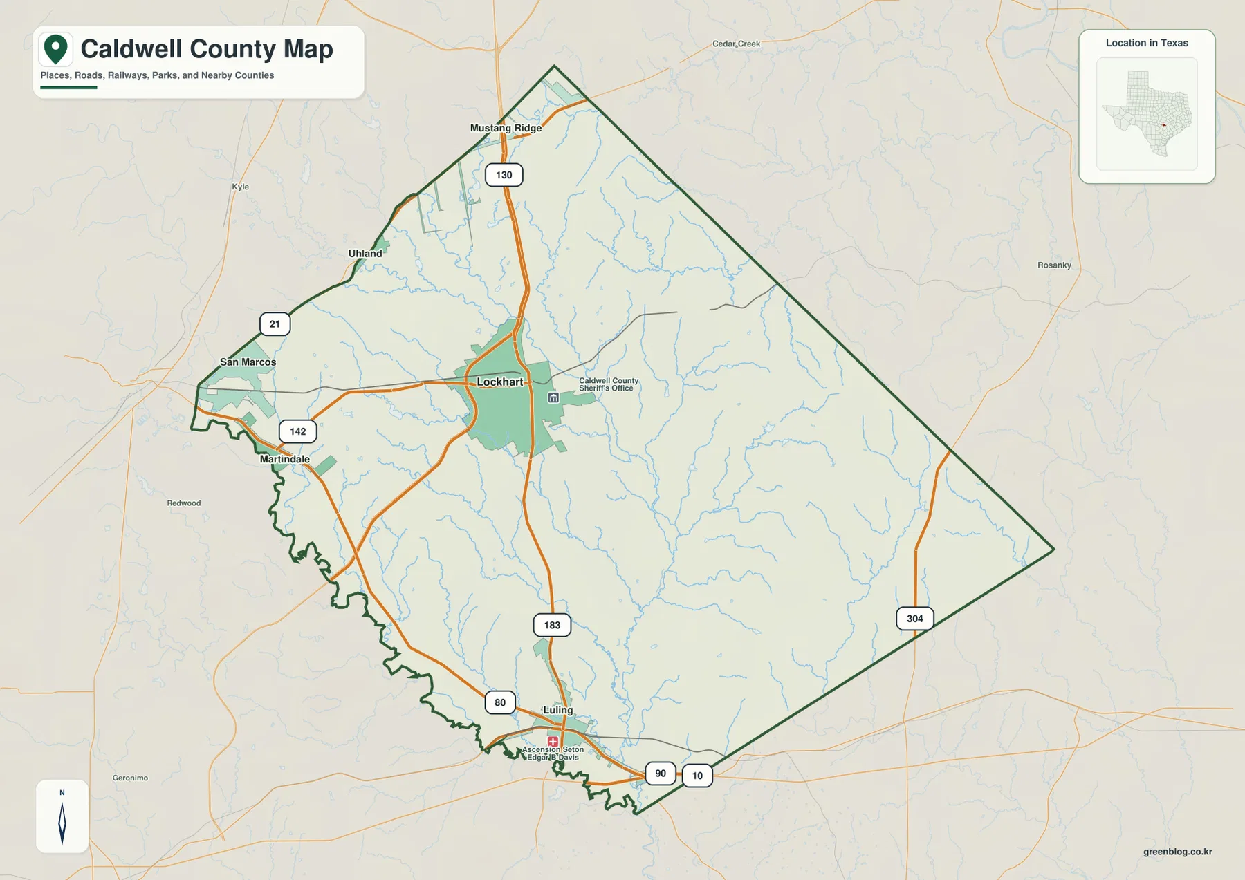
Farther south, the road picture changes. U.S. 183 reaches Luling, State Highway 80 crosses the southwestern part of the county, and the U.S. 90 and Interstate 10 corridor appears along the southern edge near Luling. State Highway 304 provides a north-south route on the eastern side. This distribution matters because the county does not rely on one corridor. The northwestern side relates more closely to Hays and Travis counties, while the southern edge has direct access to the east-west Interstate 10 corridor and Gonzales County. The map also shows that the western boundary is more irregular than the long straight eastern and northeastern segments.
What the Lockhart hub map reveals about town spacing
The city-connections map simplifies the county by using Lockhart as the hub and comparing it with Martindale and Luling. The displayed direct distance is about 10 miles from Lockhart to Martindale and about 14 miles from Lockhart to Luling. These are straight-line distances, not driving distances, so they should not be used to estimate a trip time. Their value is visual: they show that the two comparison towns are relatively close to the county seat but occupy different sides of the county.
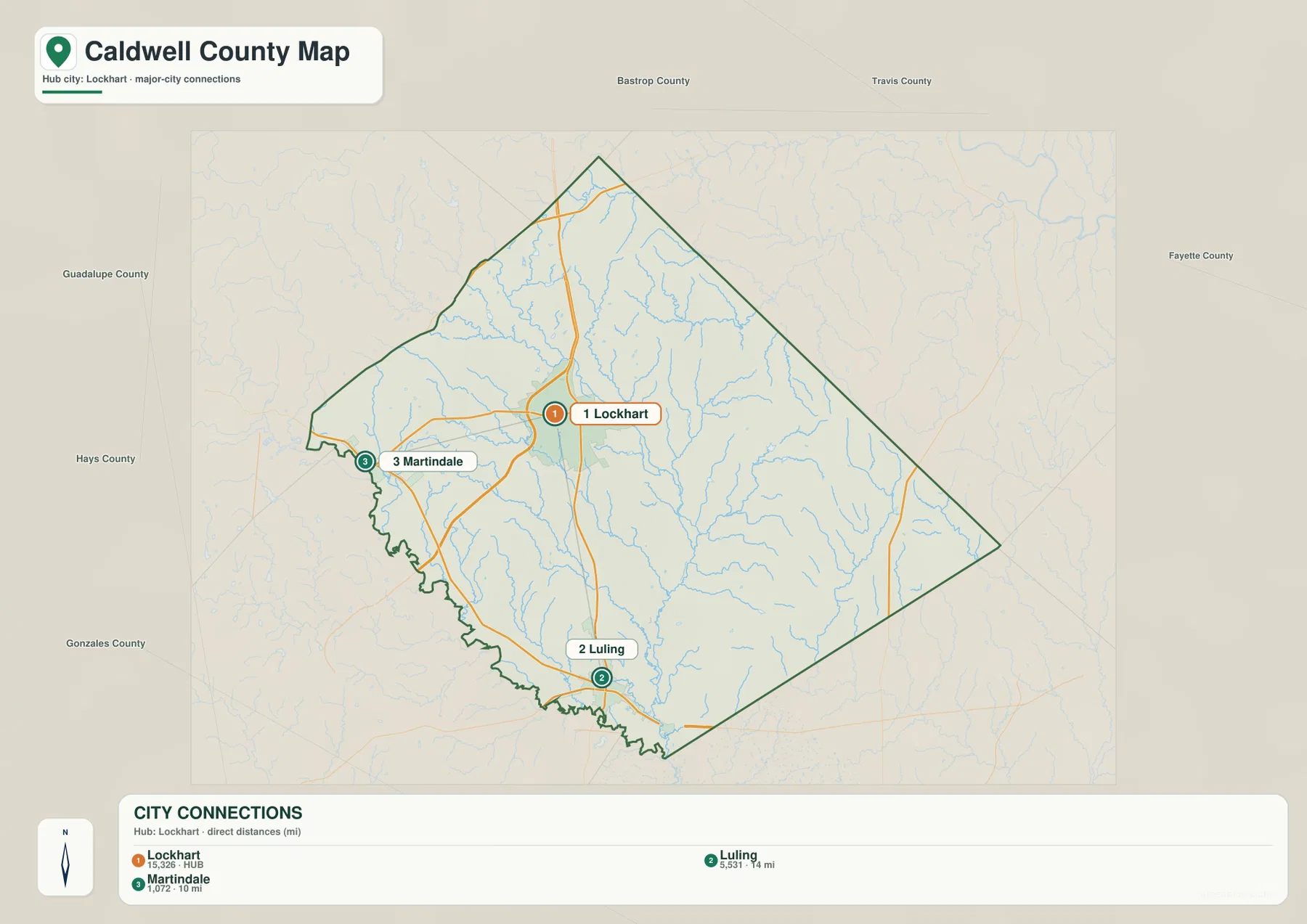
Martindale sits to the west near the Hays County side and close to the San Marcos River corridor. Luling is south of Lockhart and much nearer the Gonzales County boundary and Interstate 10. That directional contrast is easy to miss in a text list of place names. It also explains why the broader county map and the city-connections map serve different purposes. The first includes more communities and roads, including Uhland and Mustang Ridge in the northwest, while the second strips away detail so the spacing of three selected centers is immediately visible.
Plum Creek gathers tributaries across the county interior
The terrain-and-water map gives Caldwell County a very different appearance. Instead of emphasizing cities, it makes the branching drainage network the main subject. Plum Creek is the central reference, with tributaries such as Dry Creek, Elm Creek, Brushy Creek, and Walnut Creek feeding the system from the north and northeast. Clear Fork Plum Creek and West Fork Plum Creek are prominent farther west and south. The San Marcos River forms the strongest named river feature near the southwestern and southern edge.
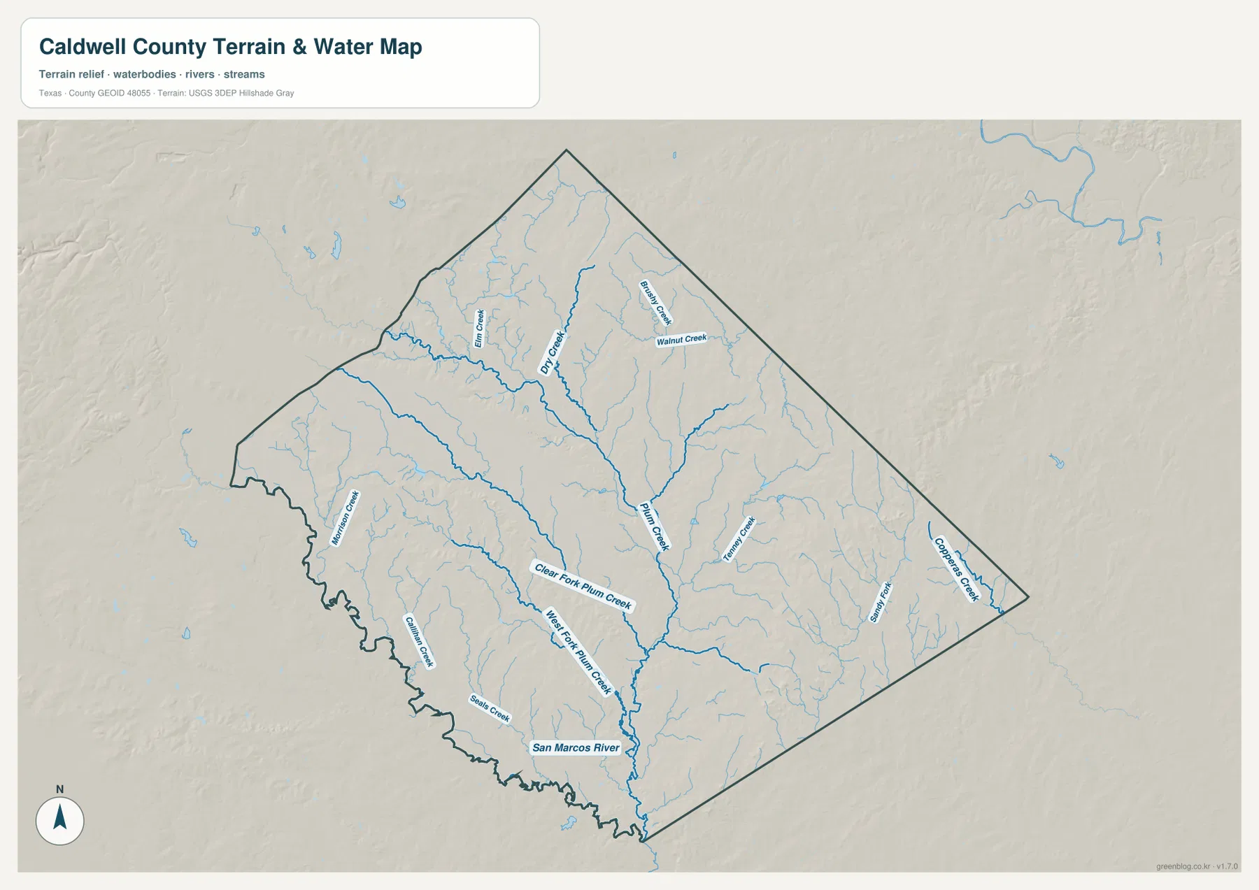
The most useful way to read this map is to follow the tributaries from the outer parts of the county toward the larger channels. Many short streams descend from the northern and eastern uplands, join longer creeks in the interior, and continue southward. Near the southwest, the drainage approaches the San Marcos River. This is a reference map for waterways and terrain; it is not a flood-hazard map, parcel map, legal water-boundary map, or navigation chart. Even with that limitation, it is valuable for understanding why the county’s road network repeatedly crosses creeks and why the western and southern edges look different from the straighter northeastern boundary.
A 93–223 meter elevation range shaped by low drainage corridors
The elevation map reports an actual range of roughly 93 to 223 meters and a mean elevation of about 151 meters. Caldwell County is therefore not mountainous, but the shaded surface still shows substantial local relief. Higher brown and orange terrain appears in parts of the north, northwest, and east, while lower green terrain runs through the middle and expands toward the south. Several narrow valleys branch into that lower central area, producing a pattern that closely resembles the creek network on the water map.
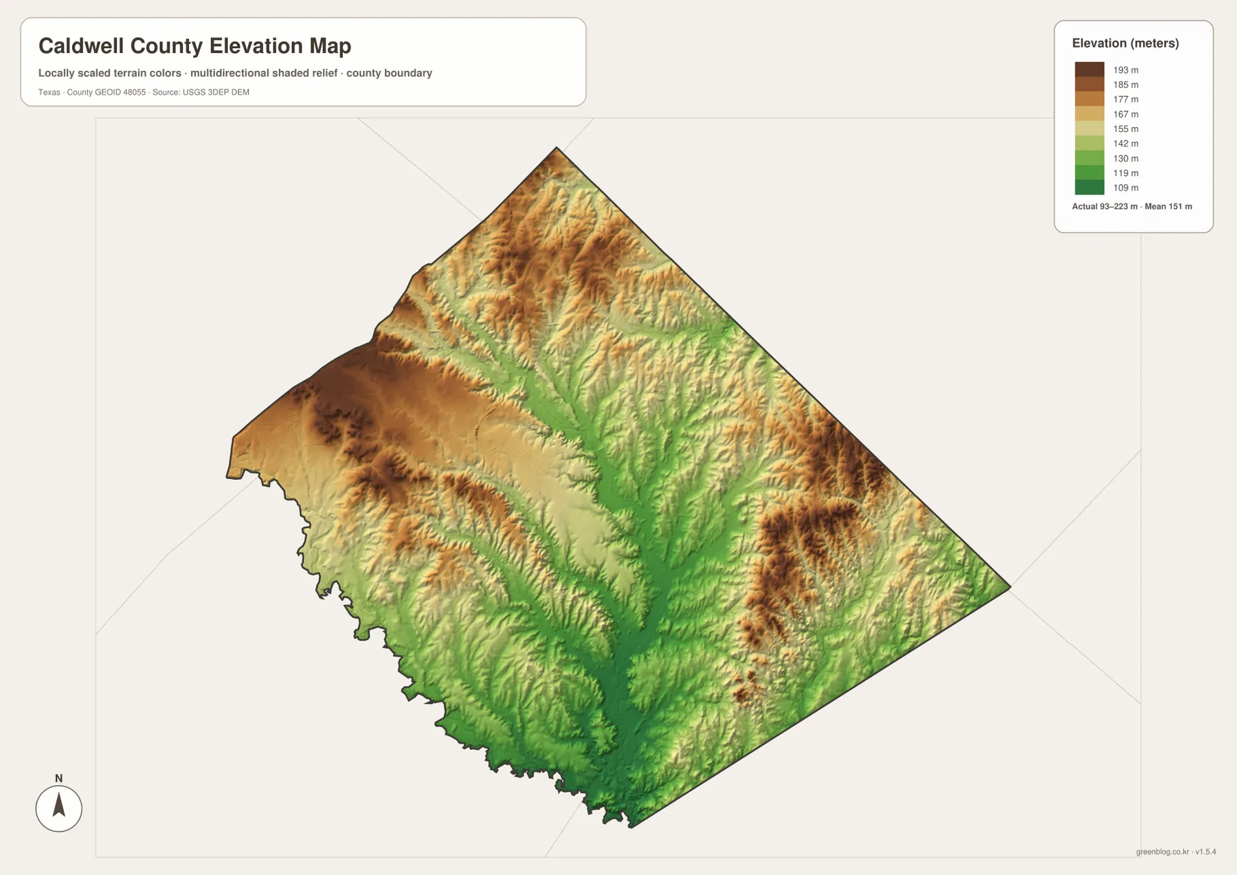
Comparing the elevation and water maps is especially revealing around Plum Creek. The main creek system follows lower ground through the county, while tributaries cut into higher terrain on either side. The same relationship can help explain why a road may bend, why crossings cluster at certain points, or why two nearby areas can look different despite being within the same county. The elevation surface is generalized for regional viewing, however, and it should not be treated as survey-grade or engineering-grade measurement for a property, road project, or construction site.
Northwest connections and the southern Luling corridor
Caldwell County has two especially useful directional contrasts. In the northwest, Uhland, Mustang Ridge, State Highway 130, and State Highway 21 place the county close to the Hays and Travis County side of the Austin–San Marcos area. The main county map shows this corner as a place where northbound and westbound connections are visually important. In the south, Luling sits near U.S. 183, State Highway 80, U.S. 90, and Interstate 10, creating a very different transportation setting. A reader who only looks at Lockhart might miss how strongly the county’s outer areas face different neighboring regions.
The eastern half is another useful contrast. It contains fewer prominent city labels on the general map, yet it is crossed by a dense network of smaller streams and includes State Highway 304. The elevation map also shows patches of higher terrain there. This combination means the east should not be interpreted as an empty part of the county simply because fewer towns are labeled. For map reading, roads, creeks, relief, and county lines are just as informative as city names.
Choosing the clearest map for a specific question
For a quick geographic overview, start with the county map because it combines named places, highways, streams, and the boundary in one view. It works well when you need to locate Lockhart relative to Luling, Martindale, Uhland, or Mustang Ridge, or when you want to see which road reaches a neighboring county. The city-connections map is better when the question is narrower: how far the selected towns sit from Lockhart and on which side of the hub they appear. Remember that its mileage labels are direct distances rather than route mileage.
If the question concerns waterways, the terrain-and-water map removes much of the road clutter and makes Plum Creek, San Marcos River, and named tributaries easier to trace. When the question shifts to hills and low valleys, the elevation map provides the clearest answer. A useful comparison exercise is to locate Plum Creek on the water map and then find the corresponding lower green corridor on the elevation map. That one comparison demonstrates how two maps of the same county can explain different parts of the same landscape without duplicating each other.
A practical reading order for Caldwell County
When using these maps for a report, lesson, trip overview, or local reference, it helps to move from the largest features to the smaller ones. First identify the county outline and Lockhart. Next trace the main roads toward Luling, Martindale, and the northwestern edge. Then add the water system, especially Plum Creek and San Marcos River. Finally compare the elevation surface to see where lower corridors and higher ridges coincide with those waterways. This order keeps the map readable because each new layer answers a different question instead of repeating the same place list.
The four map files can also be used separately. A printed county map is convenient for marking routes or neighboring counties, while the water map is easier to annotate when the subject is creeks and drainage. The elevation map is useful when a discussion needs terrain context, and the city map provides a clean visual for relative town spacing. None of these maps replaces official parcel, flood, engineering, or navigation products, but together they provide a detailed county-level reference for ordinary geographic use.
Frequently Asked Questions
Are the 10-mile and 14-mile city distances driving distances?
No. The city-connections map uses straight-line distances from Lockhart, placing Martindale at about 10 miles and Luling at about 14 miles from the hub. Actual road mileage and travel time depend on the route and the exact starting and ending points.
Which waterways are easiest to identify on the Caldwell County water map?
Plum Creek is the main interior reference, with named tributaries including Dry Creek, Elm Creek, Brushy Creek, Walnut Creek, Clear Fork Plum Creek, and West Fork Plum Creek. The San Marcos River is the strongest river feature near the southwestern and southern edge of the county.
What does the 93–223 meter elevation range tell me?
It shows that Caldwell County has noticeable local relief even though it is not mountainous. Higher ground appears around parts of the county edges, while lower corridors run through the center and south along the drainage network. The map is useful for county-scale comparison, not property surveying or engineering design.
Map File Information
The ZIP archive contains the original high-resolution A3 JPG versions of the four Caldwell County maps used on this page.
- File Type: JPG
Related Maps
- Bastrop County Texas map
- Travis County Texas map
- Austin County Texas map
- Washington County Texas map
- Wilson County Texas map
Sources and references
Boundary, road, and place-name references can be checked with the U.S. Census Bureau TIGER/Line Shapefiles and USGS The National Map Viewer. Waterway information is supported by USGS National Hydrography, and the elevation layer can be understood in the context of the USGS 3D Elevation Program.
Green Map creates custom-edited map images using open geographic data sources such as geoBoundaries, Natural Earth, OpenStreetMap, and government open data.
These maps are edited visual materials, not raw data files, and are provided for education, documents, presentations, and graphic reference.