Austin County sits west of the Brazos River in southeastern Texas, with Bellville near the middle of the county and a second concentration of communities and major roads around Sealy in the southeast. The supplied maps make that contrast easy to see: the western and northwestern side is higher and more dissected by small creeks, while the eastern edge drops toward the winding Brazos. San Felipe adds an unusual historical layer because it was the center of Stephen F. Austin’s colony long before Bellville became the county seat.
This page brings together a county reference map, a ranked city-distribution map, a waterways and terrain map, and an elevation map. Each one answers a different practical question about Austin County without requiring GIS software. The four original A3 high-resolution JPG maps are also provided together in one ZIP file below, so you can use the screen versions for orientation and then download the larger files for printing or offline reference.
Table of Contents
Start with Bellville, then follow the roads south toward Sealy
Bellville is the easiest place to use as a central reference point on the county map. It is the county seat, and the map places it where State Highway 36 and State Highway 159 come together. Highway 36 continues south toward Sealy, while 159 runs west toward Industry. That road pattern immediately separates the central part of the county from the I-10 corridor farther south.
Sealy stands out for a different reason. Interstate 10 and U.S. 90 cross the southern part of Austin County around Sealy, giving the community a strong east-west connection that Bellville does not have. From Sealy, Highway 36 continues south toward Wallis, while San Felipe lies to the northeast closer to the Brazos River. If you are trying to understand a route through the county rather than simply locate the county seat, Sealy often becomes the more useful anchor.
The western side of the county is much less concentrated. Industry appears northwest of Bellville along the 159 corridor, and New Ulm sits farther west near the county edge. The surrounding county labels help with orientation as well: Washington County is to the north, Waller and Fort Bend lie to the east, and Colorado, Fayette, and Wharton counties frame much of the west and south. Along the eastern side, the boundary bends repeatedly instead of following a simple straight line because it follows the Brazos River for long stretches.
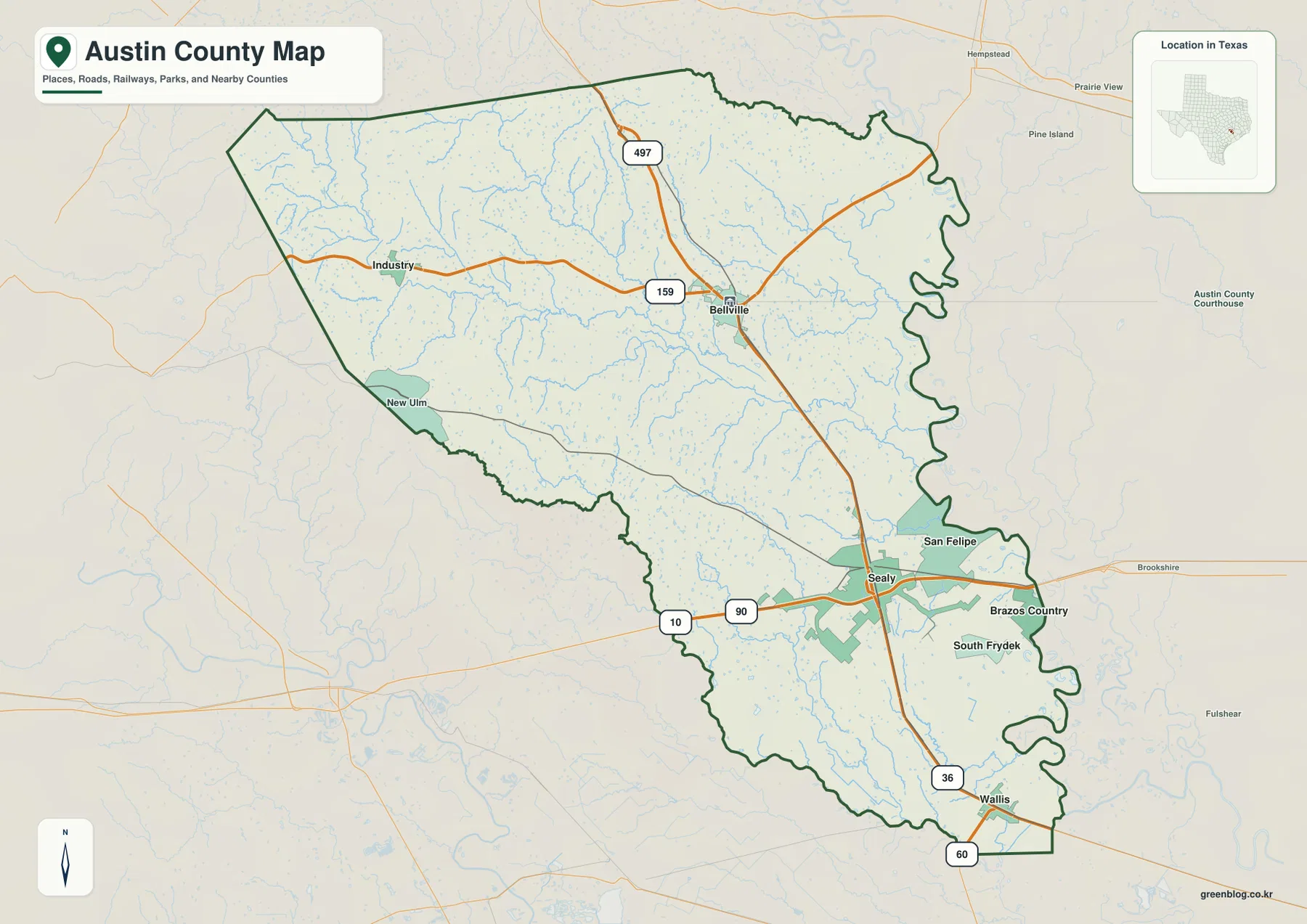
For everyday orientation, this is the most complete single map in the set. It works well when you need to place Bellville relative to Sealy, follow Highway 36 through the county, compare Industry and New Ulm with the southeastern communities, or see how Austin County fits between its neighbors. The water and elevation maps add more detail later, but this map provides the geographic frame that makes those details easier to interpret.
The six-place city map explains why Bellville and Sealy both matter
The city-distribution map highlights six named places: Sealy, Bellville, Wallis, San Felipe, Brazos Country, and Industry. Sealy is ranked first in the supplied city index and Bellville second, while Wallis, San Felipe, Brazos Country, and Industry follow. More important than the ranking itself is the pattern on the page. Four of the six markers sit in the eastern or southeastern half of the county, while Industry represents the more widely settled northwest.
Bellville and Sealy serve different map-reading purposes. Bellville is near the county’s center and is the seat of government, so it is the natural reference for county administration and the roads that cross the interior. Sealy is farther south and is tied directly to I-10, U.S. 90, and Highway 36. A reader looking for the courthouse area will start with Bellville; someone trying to place the interstate corridor, San Felipe, Wallis, or the Houston-facing side of the county will often start with Sealy instead.
San Felipe gives the city map a historical dimension that a population ranking cannot show. The Texas Historical Commission identifies San Felipe de Austin as the place where Stephen F. Austin established the headquarters of his colony in 1823. The community later served as Austin County’s seat before county government moved to Bellville in the 1840s. Seeing San Felipe near the Brazos and Bellville farther inland helps explain why two relatively close places can represent very different periods in the county’s history.
Industry also helps balance the picture. It is isolated from the southeast cluster and sits in the higher western half of the county, near a dense network of small creeks. That placement matches the broader settlement pattern shown on the reference map: the county is not one continuous urban corridor. It has several distinct small-town centers separated by rural land, creek valleys, and different road connections.
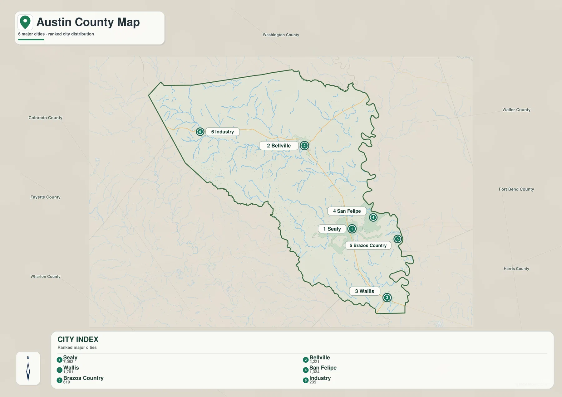
Use this map when the question is about relative placement rather than turn-by-turn travel. It is especially helpful for comparing which communities lie near the Brazos side of the county, which sit along the southern road corridor, and which are farther west. For actual driving routes, the county reference map is the better companion because it shows the main highways at the same time.
The Brazos shapes the eastern edge while Mill Creek crosses the interior
On the waterways map, the Brazos River is the dominant feature. It runs along much of Austin County’s eastern boundary in a series of broad bends, which explains the irregular shape of that side of the county. San Felipe and Brazos Country lie close to this river edge, while Sealy is slightly farther west but still in the lower southeastern part of the county.
Inside the county, Mill Creek and its branches form a second organizing pattern. The map labels Mill Creek, West Mill Creek, East Mill Creek, Sandy Creek, and Piney Creek, along with many smaller unnamed channels. In the northern and western halves, short tributaries are closely spaced across the rolling terrain. Farther east, several named creeks extend toward the lower Brazos side of the county.
Several smaller water bodies provide useful local reference points. Butler Lake and Peters Lake appear in the central portion of the map, while Lake Virnau is farther south. Near the southern end, the San Bernard River and Allens Creek are labeled close to the county boundary. These features can be difficult to pick out on a general road map, so the water map is the better choice when a creek or lake name is the main reason for opening the page.
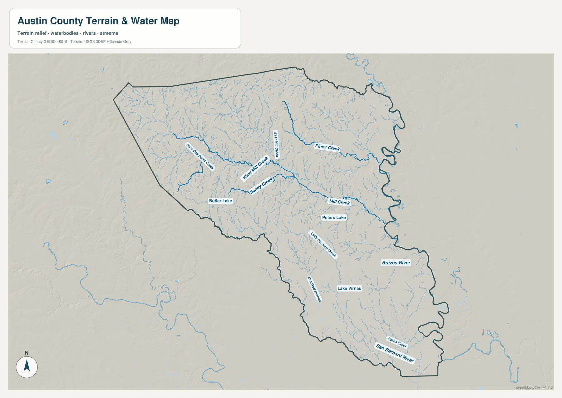
This is a geographic water-reference map, not a flood-risk or navigation product. The presence of a stream near a town or road does not tell you whether a property is in a floodplain, and the map does not show channel depth, discharge, levees, or legal water boundaries. It is best used to understand where the county’s named waterways sit in relation to communities, roads, and terrain.
Elevation reveals a clear drop from the western hills toward the southeast
The elevation map makes a pattern visible that is only hinted at by the road map. Its legend spans roughly 20 to 143 meters, with a mean value near 70 meters. Brown and tan shades cover much of the west and northwest, while green shades spread across the east and southeast. In simple terms, the county is higher and more rolling on the western side and lower toward the Brazos and the southern prairie.
The relief is especially noticeable in the northwest, where narrow ridges and valleys create a textured surface. Moving east, those ridges become lower and the land appears smoother. The southeastern section around the lower creek network is mostly green, and the broad zone along the Brazos is among the lowest-looking parts of the map. This west-to-east contrast is consistent with the county description in the Handbook of Texas, which characterizes northern and western Austin County as rolling and the southern area as much flatter prairie.
Comparing the elevation and water maps is useful because the two patterns reinforce each other. The higher west contains many short creek branches cutting through the rolling surface, while larger named channels cross the middle of the county toward lower ground. The maps are not designed to calculate a precise drainage path for a specific parcel, but they do show why the western half looks more broken and why the eastern edge is associated with lower river terrain.
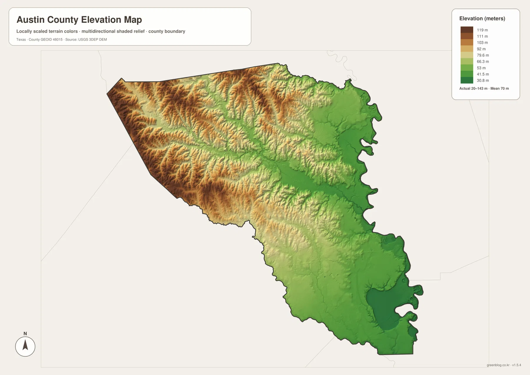
The elevation surface is generalized for county-scale comparison. It is useful for recognizing broad relief, choosing a map for a lesson or presentation, and understanding the relationship between higher ground and the creek network. It should not be treated as survey-grade elevation for construction, engineering, drainage design, or a property boundary decision.
Reading the four maps together gives each place more context
A place name means more when the maps are compared rather than viewed in isolation. Bellville is a central road junction on the reference map, a major settlement on the city map, and a location between the higher western country and the lower Brazos side on the elevation map. Sealy sits on the I-10 and U.S. 90 corridor, appears first in the supplied city ranking, and occupies the lower southeastern half of the county. San Felipe is smaller but gains importance from its position near the Brazos and its role in early Texas history.
Industry and New Ulm show the other side of the county. They are far from the southeastern concentration of towns and highways, and the elevation map places their side of Austin County in more strongly rolling terrain. The water map adds a dense web of small creeks to that western setting. Those layers explain why the western part of the county looks different even before land use or property information is considered.
Choose the county map first when you need boundaries, highways, and town names on one page. Choose the city map when you want a cleaner comparison of the six highlighted communities. The water map is best for locating the Brazos, Mill Creek branches, named lakes, and the San Bernard River. The elevation map is the quickest way to see the west-to-east change in relief. For a printed report or classroom handout, using two maps together often communicates the county more clearly than trying to force every detail into one figure.
Frequently Asked Questions
Should I use Bellville or Sealy as the main reference point?
Use Bellville when you are orienting yourself around the county seat, central Austin County, or the Highway 36 and 159 area. Use Sealy when the question involves I-10, U.S. 90, Wallis, San Felipe, or the southeastern side of the county. Looking at both gives a better sense of how Austin County has more than one practical center.
Where does the Brazos River appear on the Austin County maps?
The Brazos follows much of the eastern edge of Austin County and is shown most clearly on the water map. Its broad bends also help explain the irregular eastern county boundary. San Felipe and Brazos Country are among the labeled communities closest to that side of the county.
What does the elevation map tell me that the road map does not?
It shows the county’s broad relief: higher, more rolling ground in the west and northwest and lower terrain toward the east and southeast. The supplied elevation legend covers roughly 20 to 143 meters, but the surface is intended for county-scale comparison rather than engineering or property-level measurement.
Map File Information
The Austin County reference, city, water, and elevation maps are packaged as four original A3 high-resolution JPG files in one ZIP archive.
- Included Files: County map, city map, water map, and elevation map — 4 JPG files
- File Type: ZIP archive
Related Maps
Sources and References
The map interpretation was checked against county and state historical information and the federal mapping programs used for boundary, hydrography, and elevation context. These links provide useful starting points for readers who want more detail beyond the four downloadable maps.
- Austin County official website
- Texas Historical Commission – San Felipe de Austin State Historic Site
- Handbook of Texas – Austin County
- U.S. Census Bureau TIGER/Line Shapefiles
- USGS National Hydrography
- USGS 3D Elevation Program
Green Map creates custom-edited map images using open geographic data sources such as geoBoundaries, Natural Earth, OpenStreetMap, and government open data.
These maps are edited visual materials, not raw data files, and are provided for education, documents, presentations, and graphic reference.