The Montgomery County Alabama Map becomes much easier to understand once Montgomery is treated as the northern urban anchor rather than as the whole county. I-65 and I-85 meet around the capital, Pike Road sits to the east and southeast, the Alabama River runs along the northwestern side, and a dense network of creeks crosses the broad rural land to the south. The elevation view adds another layer: northern river country is generally lower, while the southeastern part of the county rises into a more strongly dissected landscape of ridges and valleys.
This page includes county, city, water, and elevation previews, and the original map set is available in one download. The ZIP contains four separate high-resolution A3 JPG files, which are more useful than the browser previews when you want to print a map, enlarge labels, compare water and terrain, or use a clean map in a classroom or presentation. The sections below focus on what is actually visible in the supplied maps and on county facts provided with the rewrite package.
Table of Contents
Start with Montgomery, the County Boundary, and the Highway Network
Montgomery County lies in Alabama’s River Region and borders Autauga, Elmore, Macon, Bullock, Pike, Crenshaw, and Lowndes counties. Montgomery is both the county seat and the state capital, so government, employment, and transportation are unusually concentrated in one part of the county. South of the metropolitan area, that pattern changes quickly. Long roads, wooded land, creek valleys, and lower-density settlement replace the closely spaced streets of the capital.
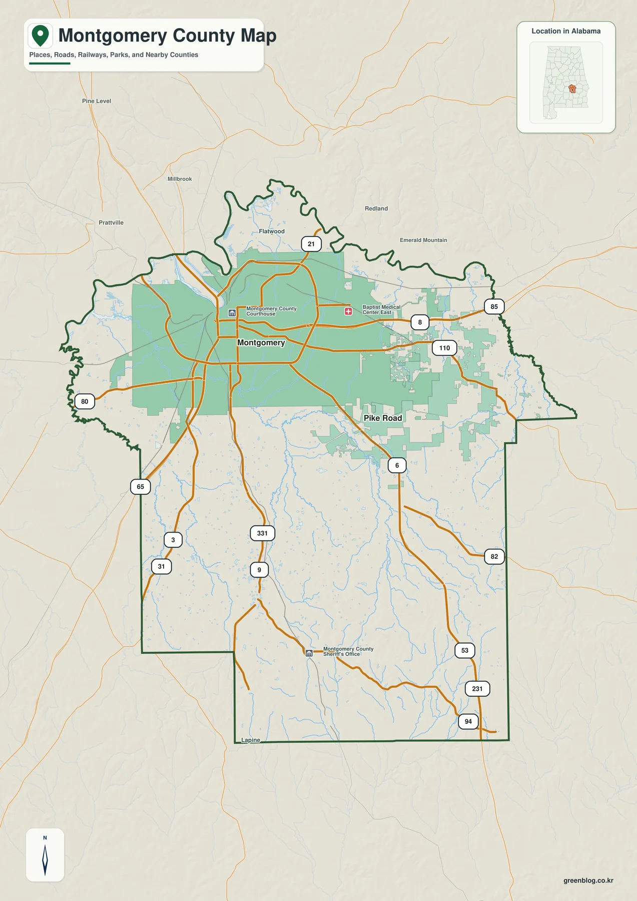
I-65 is the clearest north-south reference. It passes west of downtown, crosses the Alabama River, continues north toward Prattville, and heads south toward Hope Hull and Lowndes County. I-85 begins in Montgomery and runs northeast through the eastern side of the county toward Pike Road, Macon County, and Auburn. Their junction explains why the capital appears as a transportation hub even before local streets are added to the map.
Several U.S. highways provide the next level of orientation. U.S. 80 heads west toward Lowndes County and Selma. U.S. 231 serves the eastern and southeastern part of the county, while U.S. 331 runs south from Montgomery. The reference map also shows a number of state routes and local road connections, but the larger pattern is simple: the road network is densest around Montgomery and becomes more widely spaced in the southern half.
The source material supplied with the package lists a July 1, 2025 population estimate of 225,891 and a 2020 census population of 228,954. It also gives 785.35 square miles of land and a 2020 density of 291.5 people per square mile. Those countywide averages do not describe every part of the map equally. Dense urban neighborhoods around Montgomery, lower-density growth near Pike Road, and extensive rural land in the south are all combined in the same statistics.
The City Map Separates Montgomery from Pike Road
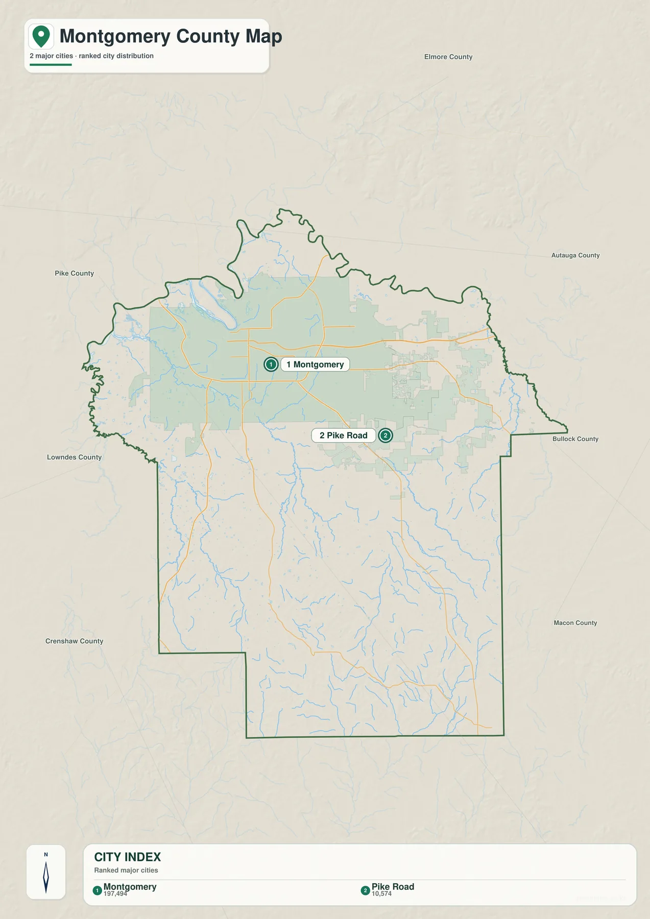
The supplied city map highlights two major incorporated places rather than filling the page with every community name. Montgomery is ranked first at 197,494 people on the map, while Pike Road is second at 10,574. Both lie in the northern half of the county, but the difference in scale is striking. Montgomery forms the broad central urban area; Pike Road appears as a smaller eastern and southeastern center.
Montgomery’s role goes far beyond its population ranking. It is the county seat and Alabama’s capital, and the existing county sources describe downtown as a river-bluff city where state government, county offices, courts, commerce, and historic districts developed close together. The city later gained major rail and highway connections, but the Alabama River remained a defining edge of the original urban core.
Pike Road presents a very different municipal story. The provided source material identifies it as a community incorporated in 1997, with planned residential growth, schools, and agricultural land all part of its modern identity. Its location near I-85 and U.S. 231 helps explain the eastward suburban pattern visible on the reference map. It is close enough to the capital to be part of the wider metropolitan area but distinct enough to appear as its own ranked place on the city map.
Two federal installations add more complexity to the metropolitan side of the county. Maxwell Air Force Base occupies the western side of Montgomery near the Alabama River, while Gunter Annex is northeast of downtown. The package sources connect Maxwell with the Wright brothers’ civilian flying school site and identify Air University as a major current function. These locations mean that commuting and employment are not centered only on the state-government core.
The Alabama River Leads into a Much Denser Water Network
The northwestern Alabama River is the most recognizable water feature, but the water map shows that it is only part of the county’s hydrology. The Tallapoosa River is labeled near the north, while Catoma Creek, Pintlala Creek, and Ramer Creek cross the interior. Numerous thinner tributaries branch across the southern half, where there are fewer city streets to distract from the drainage pattern.
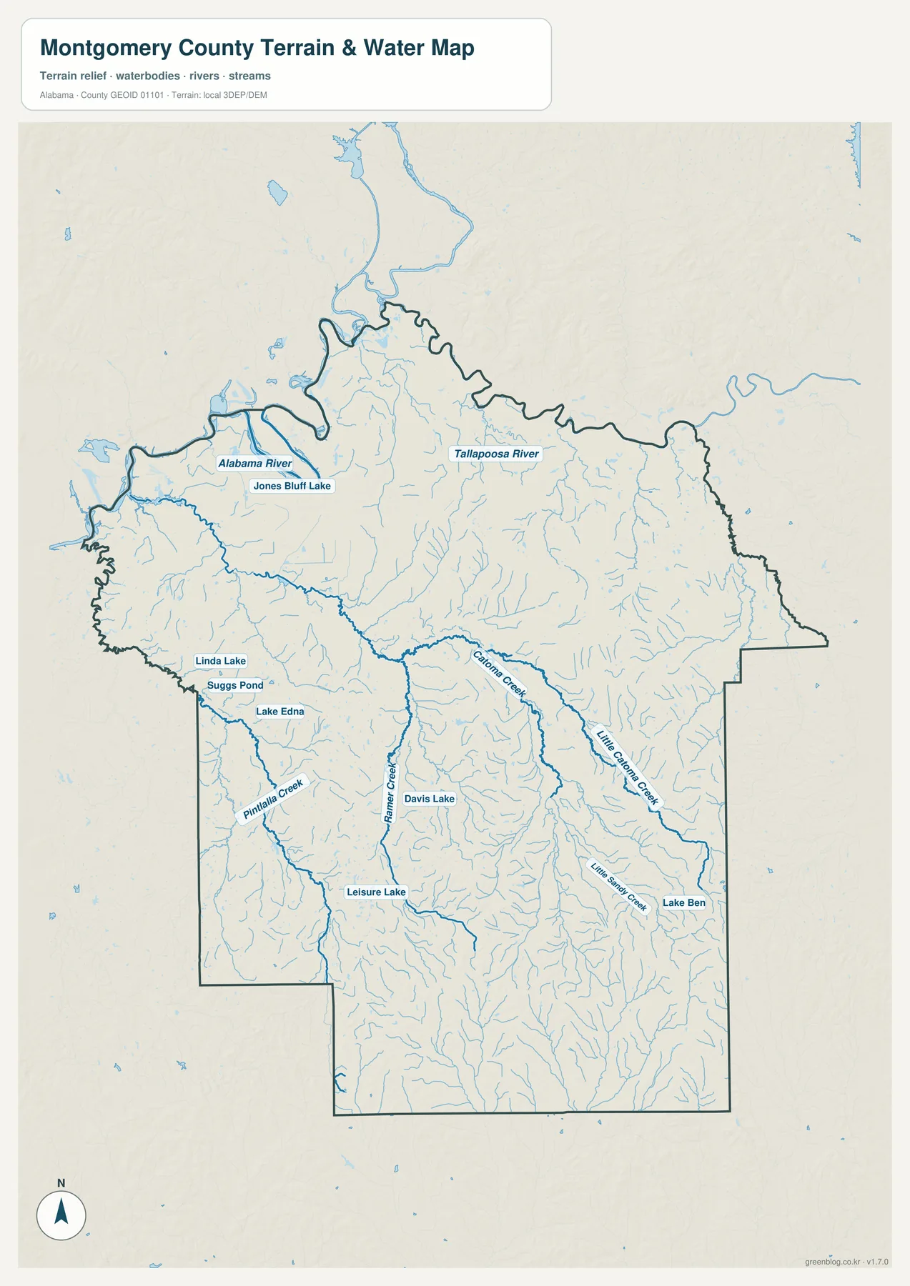
Jones Bluff Lake appears near the Alabama River in the northwestern part of the map. Farther south and west, Linda Lake, Suggs Pond, and Lake Edna form a cluster of smaller water bodies. Davis Lake and Leisure Lake provide useful interior reference points, and Lake Ben appears toward the southeast. None has the regional scale of the Alabama River, but their labels are helpful when locating surrounding creeks and rural roads.
Catoma Creek is especially visible because it bends across the central part of the county before continuing west. Pintlala Creek occupies the southwestern side, and Ramer Creek stands out farther south. When these streams are compared with the elevation map, many of them can be seen occupying lower corridors between ridges rather than cutting randomly across the terrain.
This is a geographic water reference, not a flood-insurance, parcel, or navigation map. It is appropriate for locating named waterways, comparing drainage across the county, or seeing how water relates to roads and terrain. Flood-risk decisions, legal access questions, and boating conditions require the relevant current official sources. Keeping that distinction clear makes the map more useful rather than less useful.
Elevation Rises toward the Southeastern Ridges
The supplied elevation map reports an actual range of about 36 to 185 meters and a mean elevation of 83 meters. Darker greens dominate much of the northern and northwestern county, including the broad river side. Tan and brown colors become more common toward the southeast, where the shaded relief reveals a more strongly broken surface of narrow ridges and valleys.
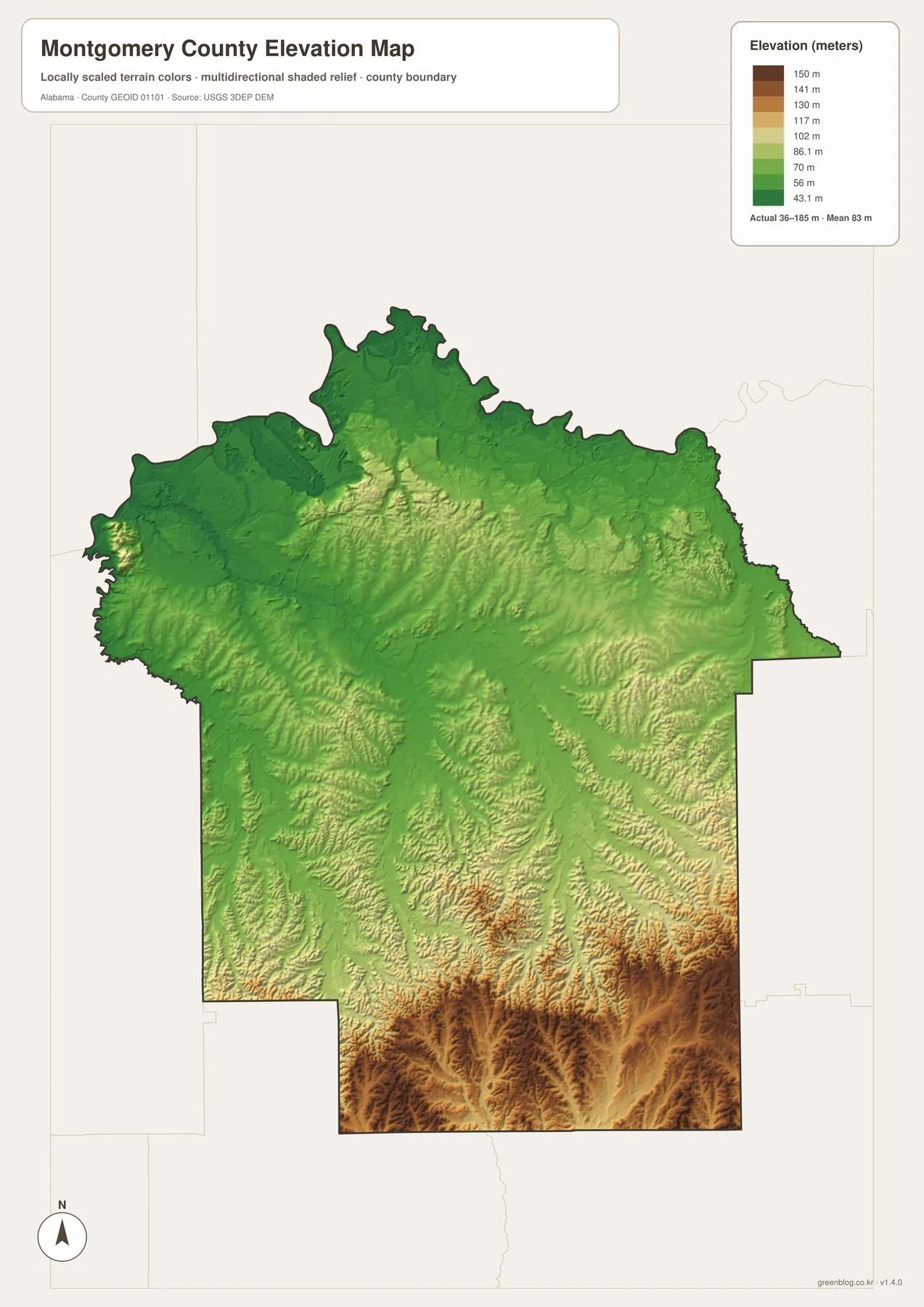
The southeastern corner contains the strongest concentration of higher colors, but elevated ridges are also visible through parts of the south-central interior. By contrast, the northern half is generally lower and smoother. This does not make Montgomery County mountainous; the more useful observation is that the county has meaningful local relief that is easy to miss on a road map.
Water and elevation are particularly informative when viewed together. The Alabama and Tallapoosa river areas occupy low ground, and the smaller creeks follow valleys through the interior. South of the metropolitan core, shaded ridges appear on both sides of many drainage lines. This relationship helps explain why the southern county can look heavily dissected even though the absolute elevations remain modest.
The map is intended for county-scale comparison, not survey work. Colors and shaded relief are excellent for showing which parts of the county are relatively high or low, but they should not replace engineering elevation measurements, site surveys, or detailed contour data. For general geography, trip preparation, teaching, or a regional presentation, the level of detail is well suited to the task.
U.S. 80 Links Modern Travel with Civil Rights History
U.S. 80 is a practical westward route from Montgomery, but it also carries a historical identity that most county highways do not. The package sources identify it with the final approach of the Selma to Montgomery National Historic Trail. The 1965 Voting Rights March covered about 54 miles from Selma to the capital, so the western highway corridor connects the county map directly with a nationally significant movement route.
The capital itself is central to that history. The supplied background material notes that the 1955–1956 Montgomery Bus Boycott began after Rosa Parks’s arrest, and that the Selma-to-Montgomery voting-rights march reached the city roughly a decade later. On the map, this makes the relationship among U.S. 80, downtown Montgomery, and the riverfront more than a transportation question. It is also a way to place historical events in a real geographic setting.
The Alabama River provides an older layer of the same story. Montgomery’s early settlement developed on the bluff above the river, with commercial and residential lots oriented toward river access before railroads and highways became dominant. The source catalog also includes current U.S. Army Corps of Engineers Alabama River navigation charts, reinforcing that the river has remained a working regional corridor as well as a visible landscape feature.
Pick the Map That Best Fits the Question
Use the county reference map when the main goal is orientation: it combines the boundary, Montgomery, Pike Road, numbered highways, and visible streams. The city map is better when the question is simply how the two main incorporated places compare in size and position. For named creeks, lakes, and river branches, the water map removes much of the transportation clutter. The elevation map is the fastest way to compare the lower north with the higher, more dissected southeast.
The maps also work well in pairs. A county map beside the city map is useful for settlement and transportation. The water and elevation maps show how streams occupy valleys between ridges. If you are studying U.S. 80 and civil-rights history, the county map gives the road context while the water map helps place the route relative to the Alabama River and western lowlands.
The embedded WebP images are optimized for quick page loading. The downloadable archive contains the four larger A3 JPG originals as separate files, which makes it easier to zoom into labels, print one map at a time, or place the maps side by side in a presentation.
Frequently Asked Questions
Are the City of Montgomery and Montgomery County the same area?
No. Montgomery is the county seat and the largest city, but the county extends well beyond the urban area. Pike Road, southern rural communities, major creeks, and broad areas of forest and farmland are all inside the county boundary.
Where is the Alabama River on the Montgomery County map?
The Alabama River is most prominent along the northwestern side of the county and northwest of downtown Montgomery. On the water map it appears with Jones Bluff Lake, while the Tallapoosa River is labeled farther north.
What is included in the downloadable ZIP?
The archive contains four high-resolution A3 JPG files: the county map, city map, water map, and elevation map. The WebP images in the article are previews, while the JPG files are better for printing and close label inspection.
Map File Information
Montgomery County Map Files
- Included Files: County map, city map, water map, elevation map
- File Type: 4 separate high-resolution A3 JPG files in one ZIP
Related Maps
- Abbeville, Headland, and Lake Eufaula on the Henry County Alabama Map
- Athens to Wheeler Reservoir on the Limestone County Alabama Map
- Autauga County Map
Sources and References
- U.S. Census Bureau QuickFacts – population, land area, and county statistics
- Montgomery County official Fast Facts – county background and history
- City of Montgomery official facts – city history and development
- Town of Pike Road official history – Pike Road incorporation and community background
- Maxwell Air Force Base fact sheet – Maxwell and Air University background
- NPS Selma to Montgomery National Historic Trail – the U.S. 80 civil-rights corridor
- U.S. Army Corps of Engineers Alabama River Charts – navigation reference for the Alabama River
Green Map creates custom-edited map images using open geographic data sources such as geoBoundaries, Natural Earth, OpenStreetMap, and government open data. These maps are edited visual materials, not raw data files, and are provided for education, documents, presentations, and graphic reference.