Download the high-resolution St. Joseph County JPG maps in one ZIP from the file box below. The archive contains the general county, city, terrain-and-water, and elevation views at 3638×2572 pixels each. Together, the maps show the South Bend–Mishawaka urban area, the broad bend of St. Joseph River, western communities such as New Carlisle, the Kankakee–Potato Creek lowlands in the southwest, and higher ground across the south-central and eastern interior.
This St. Joseph County Indiana Map set is easiest to follow from South Bend. U.S. 31 runs north–south through the area, State Road 2 heads west toward New Carlisle, and U.S. 20 connects the Mishawaka–Osceola side with the southern road network. South Bend and Mishawaka form the county’s densest settlement cluster, while New Carlisle, North Liberty, Lakeville, and Walkerton are spread much farther apart outside the urban core.
The natural maps divide the county in a different way. St. Joseph River bends through the north-central urban area, while Kankakee River and Potato Creek occupy a separate low region in the west and southwest. The elevation legend reports an actual range of about 200 to 282 meters and a mean of 236 meters. Green low ground follows the main river valleys and spreads across the west, while orange-brown higher terrain becomes more prominent through the south-central and eastern interior.
Table of Contents
South Bend and Mishawaka combine the county’s densest roads with a major river bend
South Bend is the clearest starting point on the general county map. U.S. 31 provides a north–south reference, and State Road 2 extends west toward New Carlisle. Mishawaka lies immediately east of South Bend, with Osceola farther east near the county line. U.S. 20 crosses the eastern side of the urban area and helps connect the Mishawaka–Osceola corridor with roads heading south.
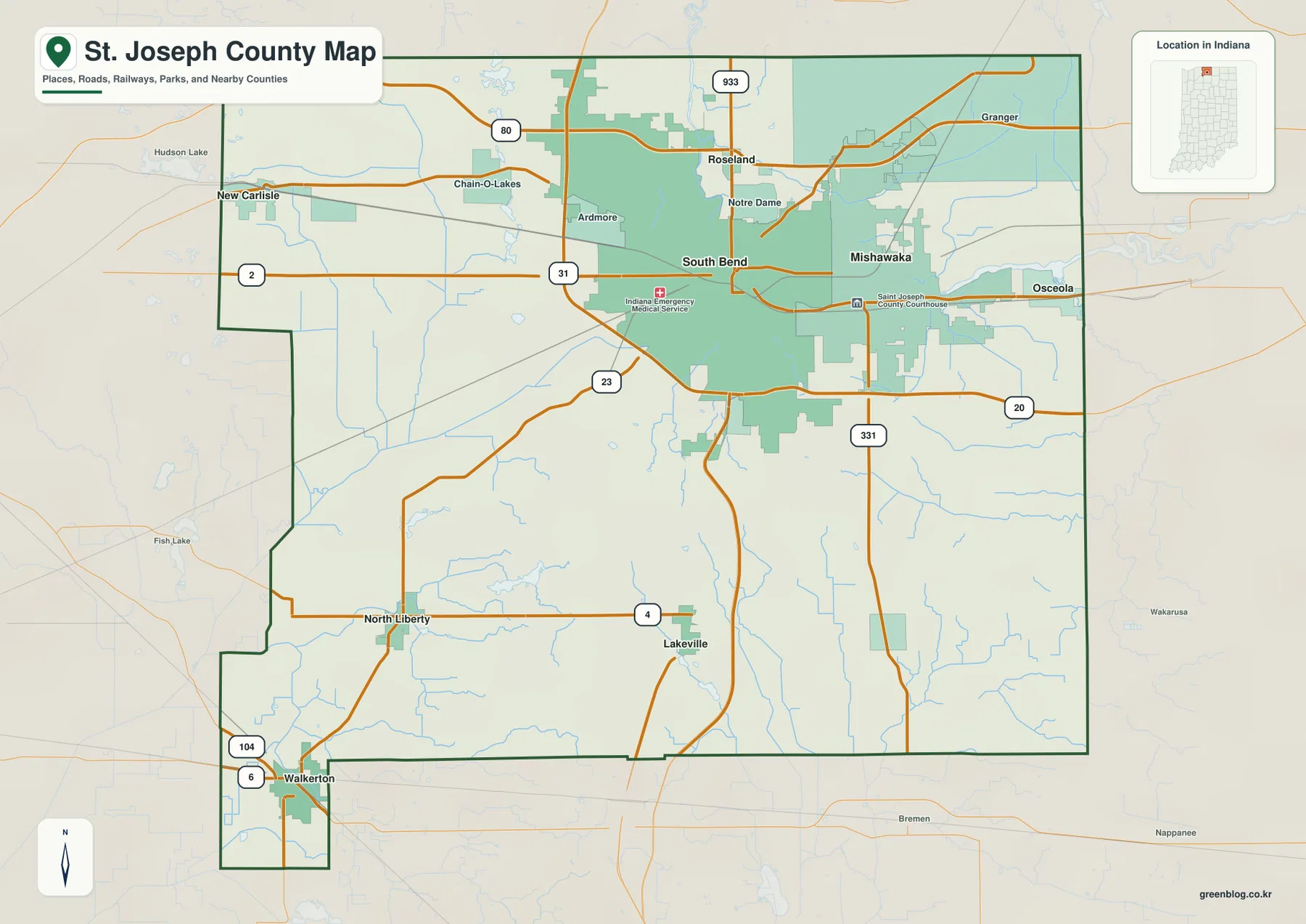
Notre Dame and Roseland are labeled just north of the South Bend core, with Granger farther northeast. Route 933 and the road marked 80 add more northern references. The number of road and place labels drops noticeably toward the south, making the contrast between the urban north and the more open southern half easy to see.
U.S. 31 continues south through the county, passing toward Lakeville in the south-central interior. North Liberty lies farther west along Route 4, while Walkerton occupies the county’s narrow southwestern extension. Because these communities are separated by larger gaps, the southern map feels much more open than the South Bend–Mishawaka area.
Route 331 provides another long north–south reference in the southeast and meets U.S. 20. Smaller waterways become more noticeable where the road network thins, so this part of the county is easier to understand when the road map is later compared with the water view. Current construction, closures, or travel restrictions should be checked with a current transportation source.
Settlement spreads quickly once the map moves beyond South Bend, Mishawaka, and Osceola
The city map highlights South Bend, Mishawaka, Osceola, Walkerton, New Carlisle, and North Liberty. South Bend and Mishawaka sit close together in the north-central and eastern urban area, while Osceola extends that cluster toward the eastern boundary. New Carlisle is well to the west, North Liberty lies southwest of the urban core, and Walkerton sits near the southwestern edge.
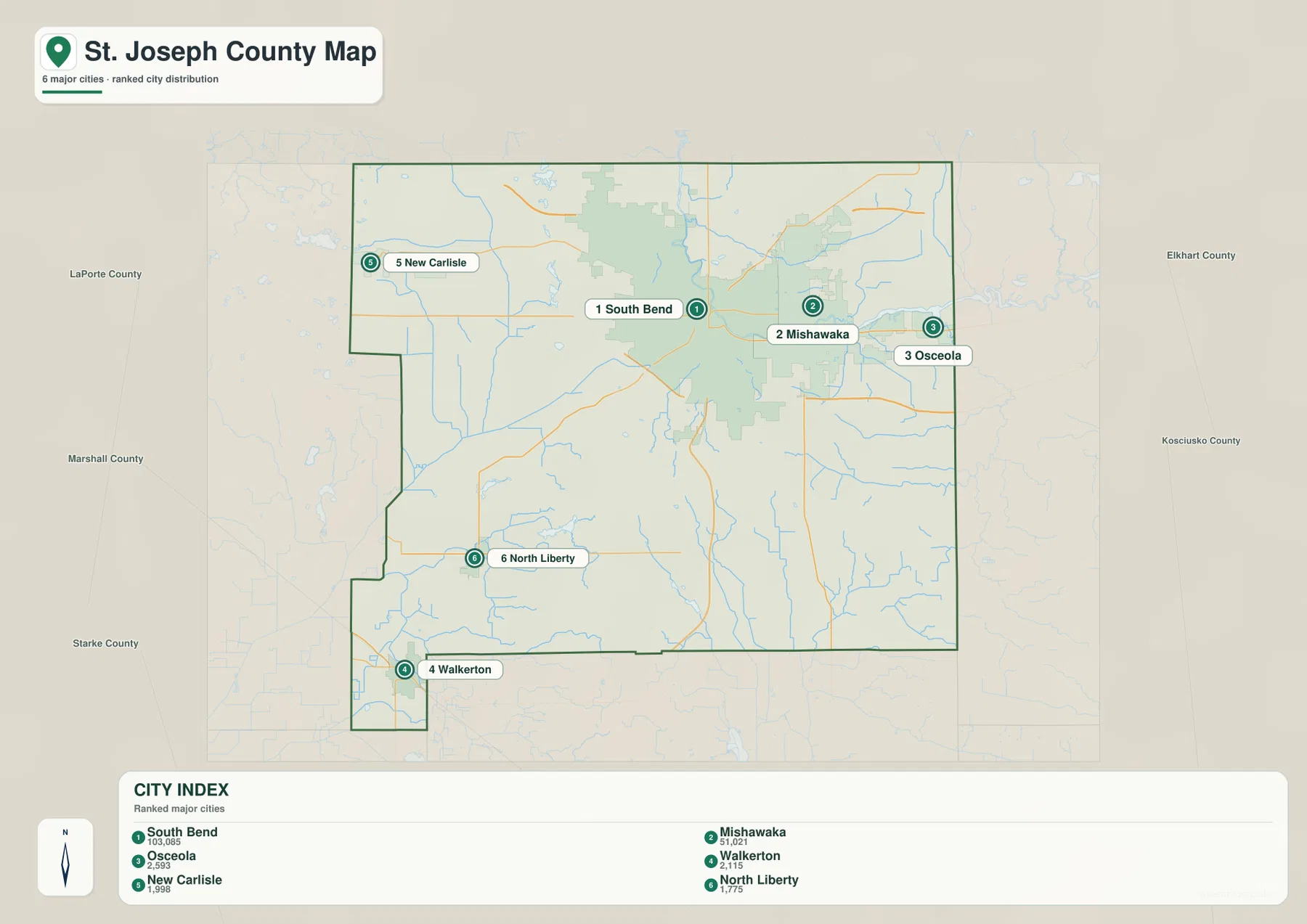
The CITY INDEX includes numeric values with the six place names, but the supplied package does not identify their year or provide a separate statistical source. This article therefore does not present them as current official population. A current U.S. Census product should be used when up-to-date population is required; here, the map is used for the verified location and spacing of the highlighted communities.
Labels for LaPorte, Marshall, Starke, Elkhart, and Kosciusko counties help place the outer communities. New Carlisle sits close to the western side toward LaPorte County, Osceola approaches Elkhart County on the east, and Walkerton lies near the southwestern boundary. The city view therefore makes the county’s wide outer area much easier to understand than the denser road map alone.
The same settlement pattern helps separate the major water regions. South Bend and Mishawaka are tied to St. Joseph River, while New Carlisle, North Liberty, and Walkerton point toward Kankakee River, Potato Creek, and several small lakes. Keeping those places in mind makes the terrain-and-water map easier to organize.
St. Joseph River and the Kankakee–Potato Creek area form two separate low-water regions
The terrain-and-water map is dominated in the north by St. Joseph River. It enters the north-central area, bends strongly near South Bend, and continues east through the Mishawaka side. Juday Creek and Willow Creek are labeled in the northeast, while Bercado Lagoon appears farther east. Together, those features define the main water setting of the county’s urban north.
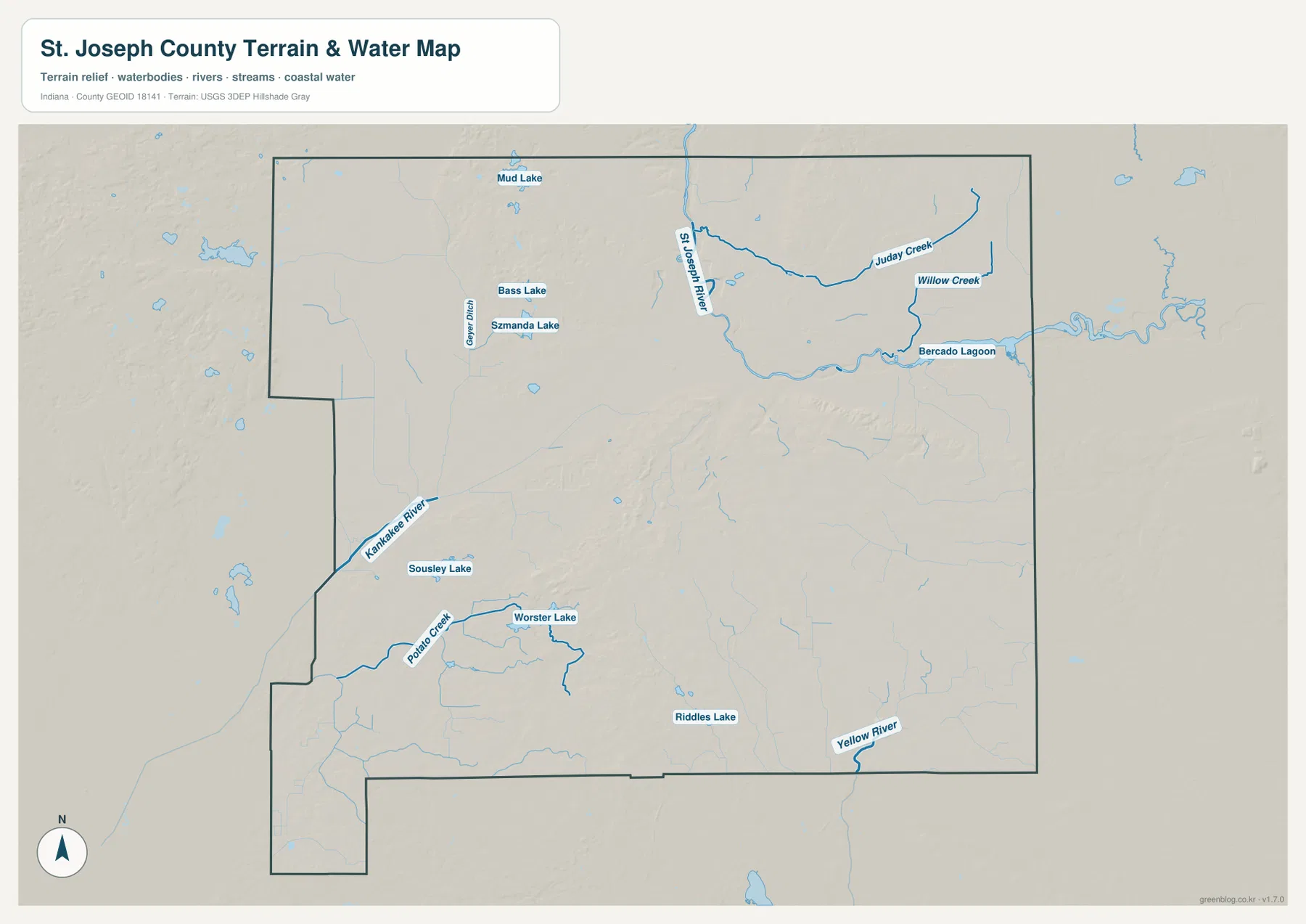
The southwest belongs to a different drainage area. Kankakee River is labeled near the western boundary, and Potato Creek bends through the interior near Worster Lake. Souseley Lake sits nearby, with Riddles Lake farther south-central. These waters are not an extension of St. Joseph River; they occupy a separate low region on the county’s western and southwestern side.
Several smaller waters appear in the northwest, including Mud Lake, Bass Lake, and Szmanda Lake, with Geyer Ditch crossing the area. Yellow River is labeled near the southern boundary farther east. A useful way to read the map is to establish the St. Joseph River corridor in the north, the Kankakee–Potato Creek lowland in the southwest, and the Yellow River side in the south before turning to the smaller lakes and ditches.
This is a county-scale water reference rather than a flood map, parcel map, legal water-boundary product, depth chart, drainage-engineering plan, or navigation guide. It is useful for locating named rivers, creeks, lakes, lagoon, and ditches and comparing them with nearby communities. Current flood conditions or site-specific water questions require dedicated agency data.
The 200–282 meter surface rises above the river lowlands in the south-central interior
The elevation legend reports an actual range of about 200 to 282 meters and a mean of 236 meters. Green marks lower terrain within the county-scale display, shifting through yellow and orange to brown at higher elevations. One of the clearest low corridors follows St. Joseph River through the north-central area, while broad low ground also extends across much of the west and southwest.
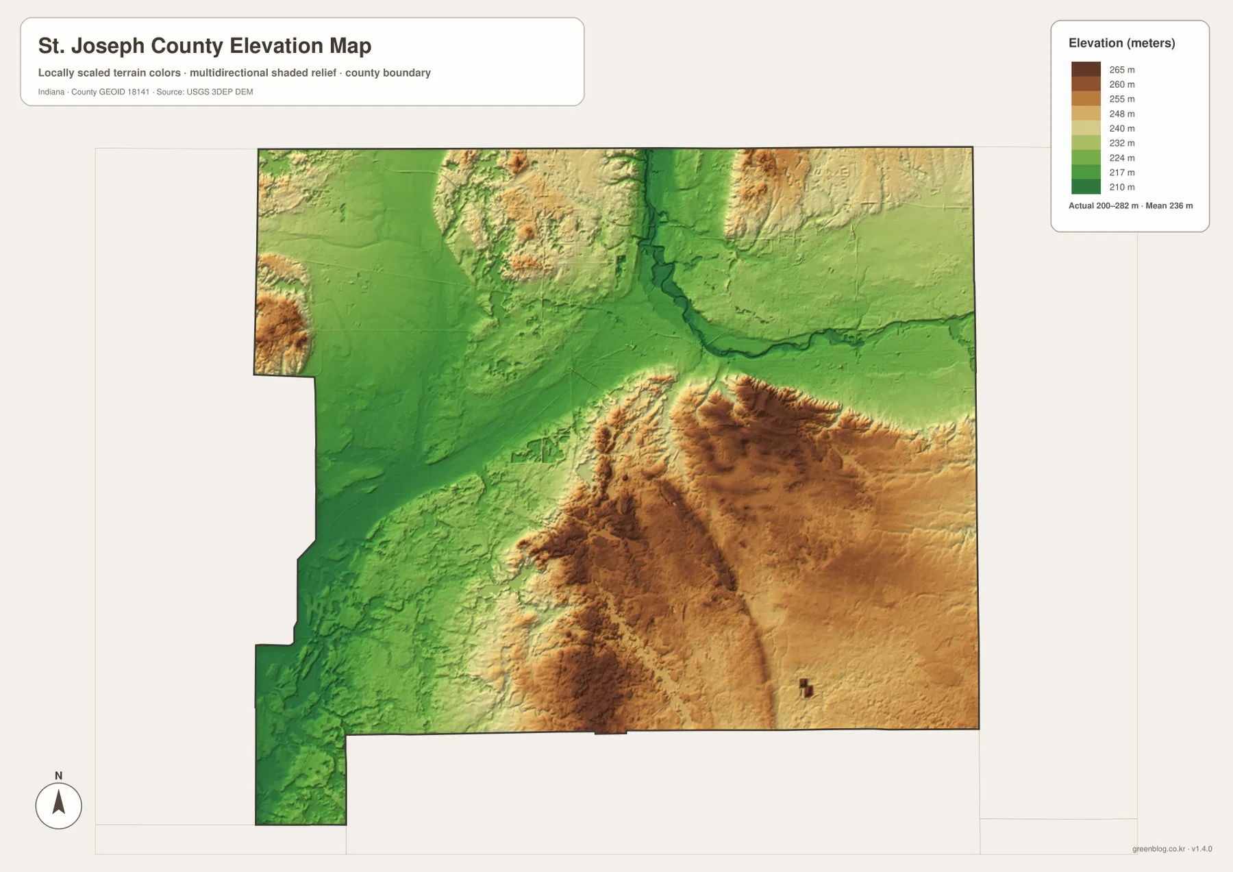
Higher terrain becomes more prominent through the south-central and eastern interior. The south-central rise sits close to lower western ground, producing a noticeable local contrast. The eastern side is also elevated in broad terms, but narrow stream valleys cut lower paths through it instead of forming one flat plateau.
St. Joseph River provides the easiest link between the water and elevation maps because its broad bend aligns with a green low corridor. Kankakee River and Potato Creek also occupy broadly low terrain, showing that two different drainage systems create separate lowlands within the same county.
The elevation image is intended for county-level comparison, not survey-grade measurement. It should not be used to assign an exact elevation to a building, road point, parcel, or construction site. The range and mean are useful regional reference values, but precise site elevations require source data or professional survey measurements.
Use South Bend as a fixed reference while moving from roads to water and relief
For ordinary orientation, begin with the general county map and locate South Bend, Mishawaka, U.S. 31, State Road 2, and U.S. 20. The city map is cleaner when the goal is simply to compare the northern urban cluster with New Carlisle, North Liberty, and Walkerton. Returning to the road map after that makes the outer routes easier to place.
For water features, use the terrain-and-water map to locate St. Joseph River, Kankakee River, Potato Creek, and the named lakes. Then find the same areas on the elevation map. St. Joseph River aligns with a broad low corridor, while the south-central and eastern interior contains noticeably higher ground.
The WebP previews are optimized for browser viewing. The downloadable ZIP contains the original high-resolution JPG versions of the general county map, city map, terrain-and-water map, and elevation map. Each file is a landscape image measuring 3638 by 2572 pixels, making the originals better for enlarging small route and creek labels or preparing an A3 print.
A practical comparison routine is to keep South Bend fixed as the reference point. Find U.S. 31, State Road 2, and U.S. 20 on the general map, compare Mishawaka and Osceola with New Carlisle on the city view, then follow St. Joseph River on the water map. Finish with the elevation map and look for the matching green river lowland.
Frequently Asked Questions
What is the easiest place to use as a starting point on the St. Joseph County maps?
South Bend is the most useful starting point because U.S. 31 and State Road 2 are easy to find, Mishawaka lies immediately east, and U.S. 20 links the eastern and southern sides of the urban area. Using South Bend and Mishawaka together also makes the St. Joseph River corridor easy to recognize.
Are St. Joseph River and the Kankakee–Potato Creek area part of the same water region?
No. St. Joseph River crosses the northern South Bend–Mishawaka area, while Kankakee River and Potato Creek occupy a separate western and southwestern lowland. The two regions are separated on the map and contain different nearby lakes, creeks, and communities.
Where does the elevation map show the clearest low terrain?
One of the clearest low corridors follows St. Joseph River through the north-central part of the county. Broad low ground also appears across much of the west and southwest near Kankakee River and Potato Creek. The legend reports an actual range of about 200–282 meters and a mean of 236 meters.
Map File Information
Download the high-resolution JPG originals for the St. Joseph County general map, city map, terrain-and-water map, and elevation map in one ZIP. Use the originals when small road or creek labels need to remain clear or when preparing an A3 print.
- Printable Size: 3638×2572 px each
Related Maps
Sources and References
The road, settlement, water, and elevation descriptions above are based on the supplied St. Joseph County maps and asset information. The official resources below are useful when source boundary, hydrography, or elevation data is needed.
- U.S. Census Bureau TIGER/Line Shapefiles – official county boundary, road, and place reference data
- USGS National Hydrography – official river and stream data information
- USGS 3D Elevation Program – elevation source data and program information
Green Map creates custom-edited map images using open geographic data sources such as geoBoundaries, Natural Earth, OpenStreetMap, and government open data.
These maps are edited visual materials, not raw data files, and are provided for education, documents, presentations, and graphic reference.