You can download the original high-resolution Hamilton County map files from this page. Hamilton County lies in southern Illinois, and the supplied maps make McLeansboro the easiest place to begin. The general view shows an east-west road marked 14 through the center of town, a southbound 142 toward Broughton, a northbound 242 toward Belle Prairie City, and a northwest route marked 6 toward Dahlgren. The WebP images below are sized for quick browser viewing; the downloadable ZIP contains the original 2572 × 3638 pixel JPG versions for printing, enlargement, and side-by-side comparison.
This county becomes more interesting when the road map is compared with the water and elevation views. Lake McLeansboro and Tenmile Creek occupy the middle of the drainage map, the Middle Fork Big Muddy River appears to the west, and the North Fork Saline River defines a different drainage direction in the southeast. The relief map reports an actual range of 106 to 191 meters with a mean of 133 meters. Higher ground is most prominent in the west and southwest, while broad lower areas spread across much of the north and east.
The official Hamilton County history page adds useful context to those map features. It states that the county was formed from White County in 1821 and named for Alexander Hamilton, and the county government identifies McLeansboro as the county seat. That helps explain why McLeansboro is emphasized on the supplied map and why the courthouse appears beside the central road junction. Rather than treating the four files as interchangeable pictures, the sections below follow the county from its road hub to small settlement spacing, named creeks and lakes, and the uneven surface shown on the elevation layer.
Table of Contents
McLeansboro sits at the road junction that organizes the county map
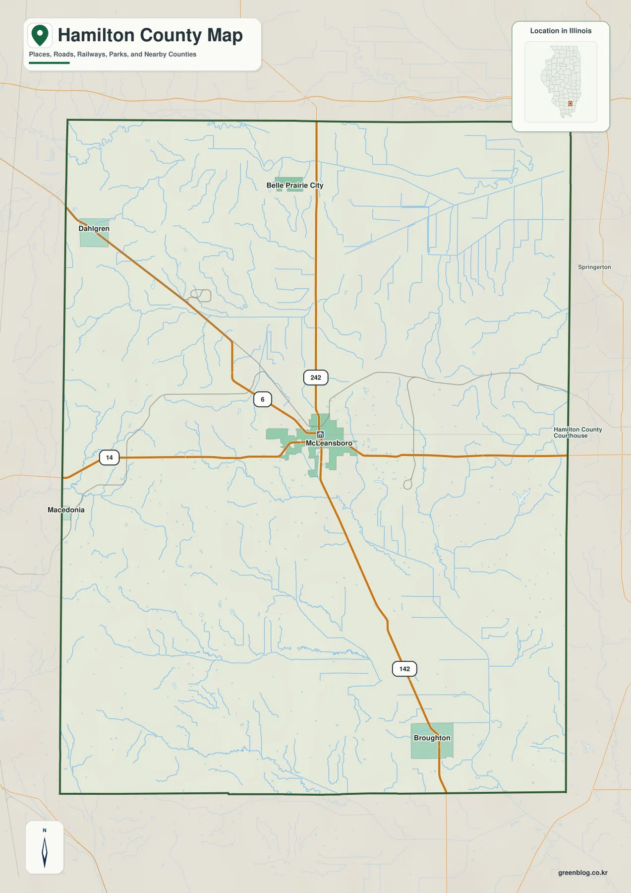
McLeansboro is near the middle of the county and gives the general map a clear frame of reference. The road labeled 14 crosses the county from west to east through town. A route labeled 142 leaves McLeansboro toward the south and continues toward Broughton, while 242 runs north toward Belle Prairie City. Another route marked 6 bends northwest in the direction of Dahlgren. Those labels create a simple compass for reading the map before any smaller road or creek is considered.
The surrounding places occupy very different parts of the county. Dahlgren is close to the northwestern side, Belle Prairie City lies across the northern interior, Broughton sits well to the south, and Macedonia is near the western boundary along the east-west road. McLeansboro is therefore not merely the largest label in the middle of the page; it is the point from which several directions can be compared at once. The county is noticeably taller north-to-south than east-to-west, so moving from Belle Prairie City to Broughton also crosses a substantial change in the creek pattern and terrain.
Names outside the boundary add regional orientation without turning the map into a legal survey. The city map labels Wayne County to the north, White County to the east, Gallatin County toward the southeast, Saline and Franklin counties to the west and southwest, and Jefferson County farther southwest. Springerton is also visible just beyond the eastern county line on the general map. These references are useful for understanding where Hamilton County sits among neighboring places, but precise boundary work should rely on current official county or Census boundary data rather than measuring from the browser image.
Four smaller map points fall within about 9–11 straight-line miles of McLeansboro
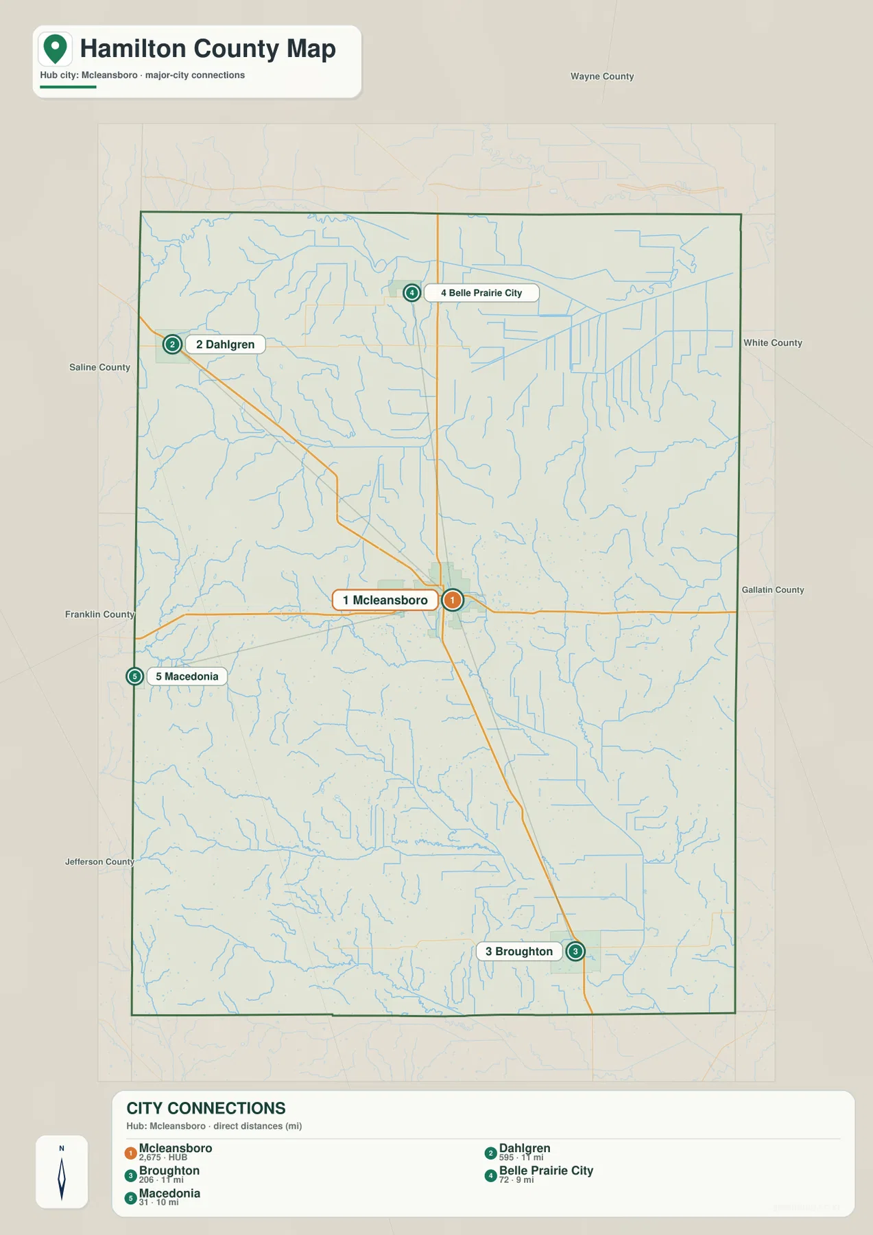
The city-connections map removes much of the road detail and reduces the county to five numbered place markers. McLeansboro is shown as the hub with an index value of 2,675. Dahlgren is listed at 595, Broughton at 206, Belle Prairie City at 72, and Macedonia at 31. These values are the figures printed on the supplied CITY CONNECTIONS graphic; this article does not treat them as live official population estimates. Anyone who needs current population statistics should use the latest Census data instead.
The distance labels are explicitly described as direct distances, so they should be read as straight-line separation rather than driving mileage. Belle Prairie City is shown about 9 miles from McLeansboro, Macedonia about 10 miles away, and both Dahlgren and Broughton about 11 miles away. Road travel can be longer because the routes bend and do not always follow the shortest line. This makes the city map most useful for visual spacing: it shows that the labeled communities ring McLeansboro in several directions rather than forming one continuous corridor.
The direction matters as much as the distance. Dahlgren and Belle Prairie City are both north of McLeansboro, but Dahlgren is distinctly northwest while Belle Prairie City sits farther east. Broughton occupies the southern part of the county, and Macedonia provides a western point near the boundary. When the city map is placed beside the general map, those five markers explain why the road network fans out from McLeansboro instead of following one dominant north-south line.
Lake McLeansboro and Tenmile Creek sit between two different drainage directions
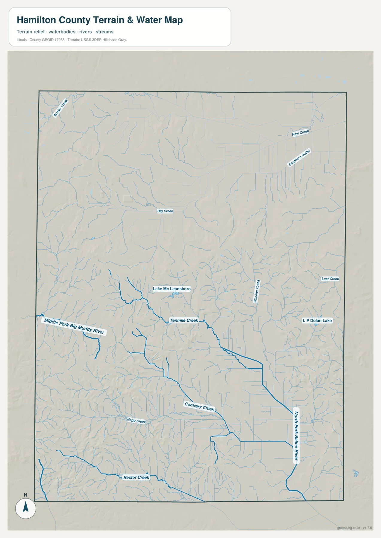
The water map changes the visual emphasis completely. Near the center-west, Lake McLeansboro connects with a creek network in which Tenmile Creek becomes one of the easiest names to follow toward the southeast. Farther west, the Middle Fork Big Muddy River represents another major drainage direction. The map therefore does not show a county dominated by one trunk stream; instead, it reveals several systems separated by ridges and shallow divides.
In the southeastern portion, the North Fork Saline River is the most prominent labeled watercourse. Contrary Creek approaches that system from the interior, while Hogg Creek and Rector Creek appear farther south and southwest. Big Creek is labeled in the northern half, and Haw Creek, Southern Outlet, and Lost Creek provide references toward the east and northeast. The density of small blue lines is important because many of the narrow valleys become easier to recognize when the same places are opened on the elevation map.
L P Dolan Lake is another useful landmark on the eastern side of the water map. The Illinois Department of Natural Resources describes Dolan Lake as the principal lake at Hamilton County State Fish and Wildlife Area, about eight miles southeast of McLeansboro. Its official page gives the lake an area of 75 acres, roughly three miles of shoreline, and a maximum depth of 18 feet. That local reference makes the eastern part of the water map more concrete, but the map itself should not be used to judge flood risk, water levels, navigation, property limits, or current access rules.
The 106–191 meter relief map rises strongly in the west and southwest
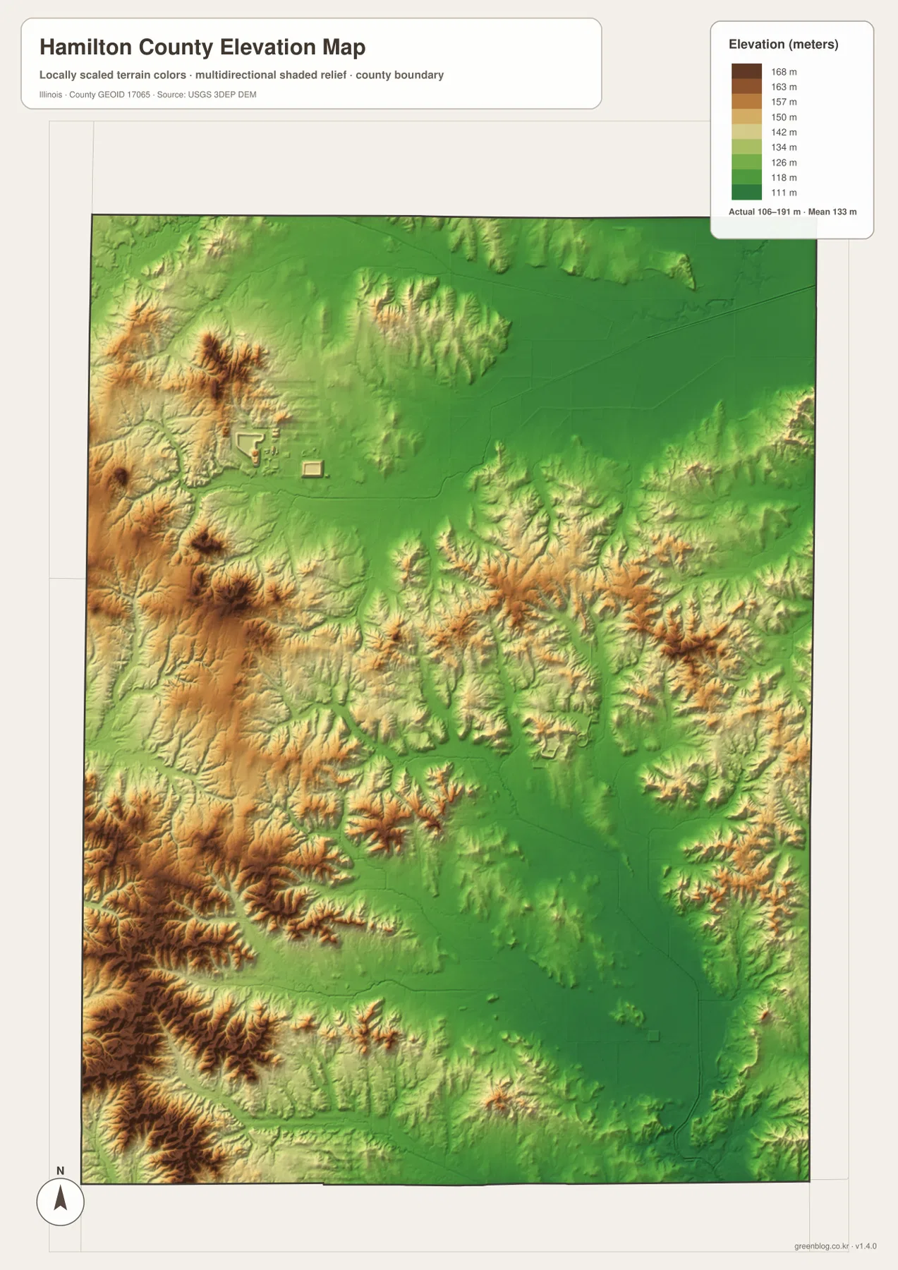
The relief legend reports an actual mapped elevation range of 106 to 191 meters and a county mean of 133 meters. The highest-looking terrain is concentrated in the west and southwest, where brown and tan ridges form a much rougher surface than the broad green areas to the north and east. Smaller ridge groups also appear through the central and eastern parts of the county. The result is a landscape that is not mountainous but is far from uniformly flat.
Comparing the relief with the water map explains some of the texture. Western streams occupy lower channels cut between the higher ridges, while Tenmile Creek follows a lower passage across the interior. The North Fork Saline River and its tributaries are associated with lower ground in the southeast. In the north and northeast, larger green areas suggest broader low surfaces with less dramatic local relief than the western side. This comparison is more informative than reading the color scale by itself because the named waterways provide recognizable anchors.
The elevation file is a county-scale reference, not a surveying or engineering surface. The color transitions are intended to show relative high and low ground, and the 106–191 meter range should not be treated as a guarantee of parcel-level elevation. Drainage design, road grading, construction, and legal surveying require original elevation data and field measurements. For ordinary geographic study, however, the map is effective at showing why western Hamilton County looks much more dissected than the broad lower areas farther north and east.
County history and Dolan Lake give the map two very different local anchors
Hamilton County’s official history page states that the county was created from White County in 1821 and named for Alexander Hamilton. The county government places the courthouse and county seat in McLeansboro, which matches the map’s visual emphasis on that town. Seeing the courthouse label beside the road junction helps explain McLeansboro’s importance without relying only on the city-index number. It is the administrative point as well as the most convenient map reference for roads leading north, south, east, and west.
Dolan Lake provides a contrasting natural reference. It is not a road hub, yet its placement in the eastern drainage map gives the southeastern part of the county a recognizable feature. Moving from McLeansboro on the road map to L P Dolan Lake on the water map and then to the nearby low and moderate relief on the elevation map is a useful way to follow one part of the county across different layers. The same method works for Lake McLeansboro and Tenmile Creek in the interior or for Dahlgren and the higher ground farther west.
This cross-reading also prevents the map set from becoming a list of file types. A place name on the general map provides orientation, a city marker clarifies spacing, a creek or lake name explains the drainage, and the relief surface shows whether the surrounding ground is comparatively high or low. Hamilton County is small enough that these relationships fit comfortably on one page, but detailed labels become much easier to read when the original JPGs are opened at full size.
Choose the Hamilton County file by the detail you need to inspect
Use the general county map when McLeansboro, Dahlgren, Belle Prairie City, Broughton, Macedonia, the county boundary, and the major road labels need to remain visible together. The city-connections file is cleaner when the question is simply how the five indexed places are spaced around McLeansboro. For Lake McLeansboro, Tenmile Creek, the Middle Fork Big Muddy River, North Fork Saline River, and L P Dolan Lake, the water map carries far more useful labeling. The elevation map is the best choice when the western high ground and the lower northern and eastern areas are the main subject.
The browser previews are intentionally smaller than the downloadable originals. Small creek labels, road numbers, and narrow relief features can be difficult to inspect at reduced size. The ZIP contains one high-resolution JPG for each supplied map, all at 2572 × 3638 pixels. They can be printed, enlarged, or placed side by side so the same location can be compared without repeatedly switching between small preview images.
Frequently Asked Questions
Are the 9–11 mile city-connection labels driving distances?
No. The supplied city map explicitly labels them as direct distances from McLeansboro, so they should be interpreted as straight-line distances. Belle Prairie City is shown about 9 miles away, Macedonia about 10 miles away, and Dahlgren and Broughton about 11 miles away. Actual road travel can be longer.
What is the L P Dolan Lake label on the eastern water map?
The Illinois Department of Natural Resources identifies Dolan Lake as the main lake at Hamilton County State Fish and Wildlife Area, about eight miles southeast of McLeansboro. The supplied water map labels it as L P Dolan Lake. It works well as an eastern orientation point, but current recreation, access, fishing, or boating rules should be checked with IDNR.
Can the 106–191 meter elevation file be used for surveying or construction?
No. It is a generalized county-scale relief map intended to compare higher and lower areas. It does not provide survey-grade spot elevations, construction tolerances, or parcel measurements. Precise work should use original USGS elevation data, current local records, and professional field surveying.
Map File Information
The ZIP contains the Hamilton County general map, city-connections map, terrain-and-water map, and elevation map as original high-resolution JPG files.
- Included Files: 4 JPG maps
- Printable Size: 2572 × 3638 pixels each
- Intended Use: Printing, education, presentations, and geographic reference
Related Maps
Sources and Reference Data
- Hamilton County, Illinois – History – county formation, naming, and local government context
- Illinois DNR – Hamilton County State Fish and Wildlife Area – Dolan Lake location and official lake information
- U.S. Census Bureau TIGER/Line Shapefiles – county boundary reference
- USGS National Hydrography – water-feature reference
- USGS 3D Elevation Program – elevation reference
Green Map creates custom-edited map images using open geographic data sources such as geoBoundaries, Natural Earth, OpenStreetMap, and government open data.
These maps are edited visual materials, not raw data files, and are provided for education, documents, presentations, and graphic reference.