Habersham County occupies a steeply varied part of northeastern Georgia where the settlement pattern is concentrated around Clarkesville, Demorest, Cornelia, Mount Airy, and Baldwin, while much higher mountain terrain dominates the north. The four maps on this page separate the county into readable themes. The general reference map shows towns, roads, streams, and the boundary; the city map ranks six major cities; the water view highlights the Soquee River, mountain creeks, lakes, and reservoirs; and the elevation map shows an actual range of roughly 207 to 1,327 meters. After reviewing the previews, you can download four high-resolution A3 JPG originals in one ZIP for printing, classroom use, reports, presentations, or local research.
Clarkesville is the most useful administrative reference because it is the county seat and sits near several major road connections. Demorest lies just south of it, followed by the Cornelia–Mount Airy area and Baldwin farther south. Tallulah Falls is separated from that central-southern cluster on the eastern side near much rougher terrain. The water and elevation maps explain the county better than city labels alone: mountain streams descend from the high north, join larger channels around the central valleys, and continue through lower ground toward the southern communities. The result is a county with a strong geographic contrast between a more settled southern corridor and high, deeply dissected northern ridges.
Table of Contents
Clarkesville and the North–South Road Pattern
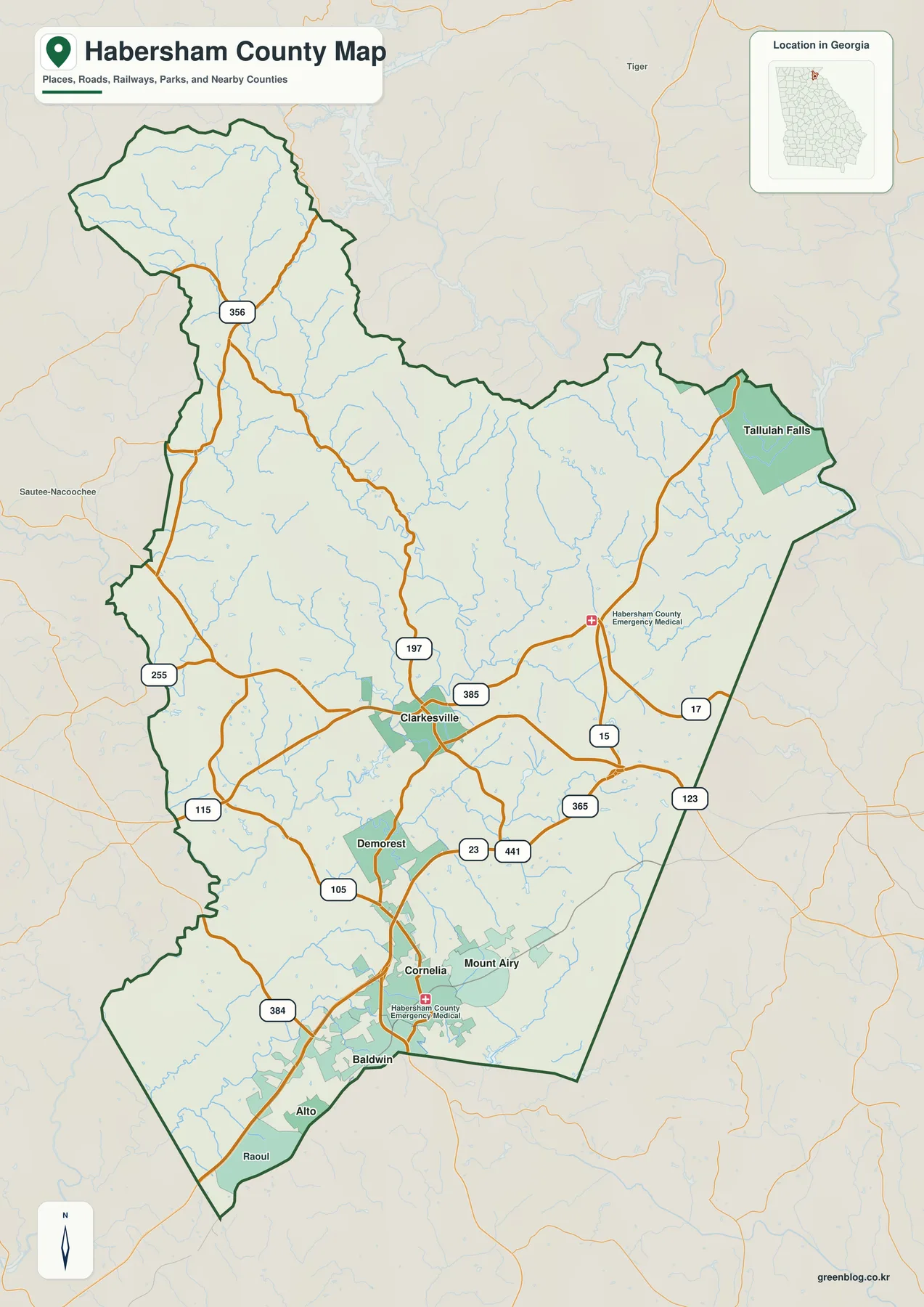
Clarkesville appears slightly south of the county’s midpoint and serves as the best place to organize the road map. Routes 197 and 385 are labeled around the city, while Routes 15, 17, and 123 provide eastern references. South of Clarkesville, Routes 23 and 441 form a strong corridor through Demorest, Cornelia, Baldwin, and Alto. Routes 255 and 356 appear toward the northwestern mountain side, while 115 and 384 provide additional western and southwestern references. These roads are useful at county scale because they show how the central communities connect with the higher northern country and the eastern Tallulah Falls side.
The settlement pattern is much denser in the center and south than in the northern half. Demorest lies directly below Clarkesville, Cornelia and Mount Airy form another close pair farther south, and Baldwin is a larger developed area near the lower edge of the county. Alto and Raoul appear as additional labels in the south. By contrast, the upper half contains far more stream lines and terrain than urban shading. That visual difference is important: Habersham County is not evenly settled from top to bottom, and the main road corridor occupies lower terrain than the highest northern ridges.
Tallulah Falls provides a separate eastern reference. It appears far from the central-southern city group, in terrain that becomes much more rugged on the relief map. The source article in the package also identifies mountain scenery, rivers, and access to Tallulah Gorge as parts of the county’s local setting. This general map is not a trail map or a detailed gorge map, but it makes the broader position clear: Tallulah Falls lies on the eastern side of a county whose highest terrain is concentrated farther north and whose principal service centers lie to the south and west.
Six Ranked Cities from Cornelia to Tallulah Falls
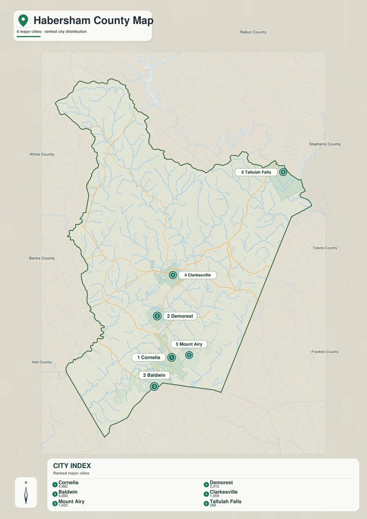
The city view removes most road and landmark detail and ranks six cities. Cornelia carries the largest displayed value at 4,992, followed by Baldwin at 4,000. Demorest is shown at 2,512 and Clarkesville at 1,959, while Mount Airy appears at 1,622 and Tallulah Falls at 288. These are the values printed on the supplied map and are included here to explain the graphic’s ranking, not as newly verified population estimates. Current official demographic figures should be checked through the Census QuickFacts source listed below.
The ranking should not be confused with administrative importance. Clarkesville remains the county seat even though Cornelia has the largest value on this particular city map. Cornelia and Baldwin anchor the southern part of the distribution, Demorest and Clarkesville form a close central pair, and Mount Airy sits just east of Cornelia. Tallulah Falls is the outlier: it is placed well to the northeast and away from the other five ranked cities. The map therefore shows a clustered central-southern urban pattern with one smaller mountain city on the eastern side.
Neighboring county names provide regional orientation around the frame. White, Banks, and Hall counties appear along the west and southwest; Rabun lies to the north; Stephens and Towns provide eastern references; and Franklin appears farther southeast. These labels are not intended for survey work, but they help show where the six-city distribution sits within northeastern Georgia. Tallulah Falls is close to the eastern side, while the Cornelia–Baldwin area lies much closer to the southern county edge.
| Map rank | City | Displayed value | General position |
|---|---|---|---|
| 1 | Cornelia | 4,992 | south-central |
| 2 | Baldwin | 4,000 | near the southern edge |
| 3 | Demorest | 2,512 | south of Clarkesville |
| 4 | Clarkesville | 1,959 | central county |
| 5 | Mount Airy | 1,622 | east of Cornelia |
| 6 | Tallulah Falls | 288 | eastern mountain side |
Soquee River, Mountain Creeks, and Small Lakes
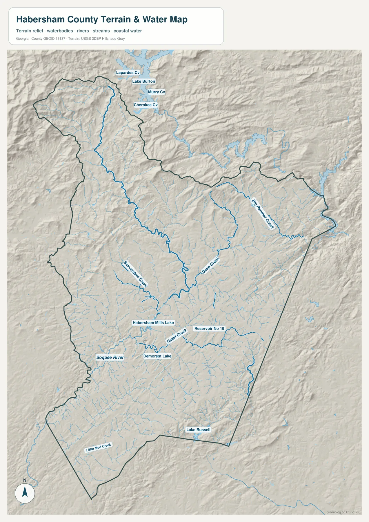
The water map makes the mountainous character of the northern county immediately visible. Numerous narrow tributaries descend from the high northwest and northern ridges, creating a dense blue network long before any large river label appears. Big Panther Creek stands out on the northeastern side, while Deep Creek occupies another central-eastern valley. Beaverdam Creek is labeled farther west and runs toward the central drainage area. The close spacing of these channels shows how deeply the northern terrain is cut by stream valleys.
Farther south, the Soquee River becomes an important named reference. It follows a lower corridor through the central-southern part of the county, with Hazel Creek and other tributaries feeding the same broader system. Habersham Mills Lake and Demorest Lake are labeled near the central-southern communities, creating useful water landmarks around the Clarkesville–Demorest–Cornelia side. Lake Russell appears near the southeastern boundary, while Little Mud Creek is labeled toward the southwest.
The map frame also shows larger water features beyond the northern county boundary, including Lake Burton and named coves such as Laprades Cove, Murray Cove, and Cherokee Cove. Those waters are outside the county focus, but they provide useful regional context for the high country immediately north of Habersham. Within the county itself, the defining pattern is not one giant reservoir. It is the repeated descent of small mountain streams into larger creeks and the Soquee River corridor.
This water view is intended for county-scale geographic orientation. Flood risk for a specific parcel, legal water boundaries, channel depth, and access conditions require the appropriate current agency or local records. For ordinary map reading, the most useful relationships are the Soquee River through the lower central area, the steep tributaries descending from the north, Big Panther and Deep Creek on the eastern side, and the small lakes near the more populated southern corridor.
Elevation from About 207 to 1,327 Meters
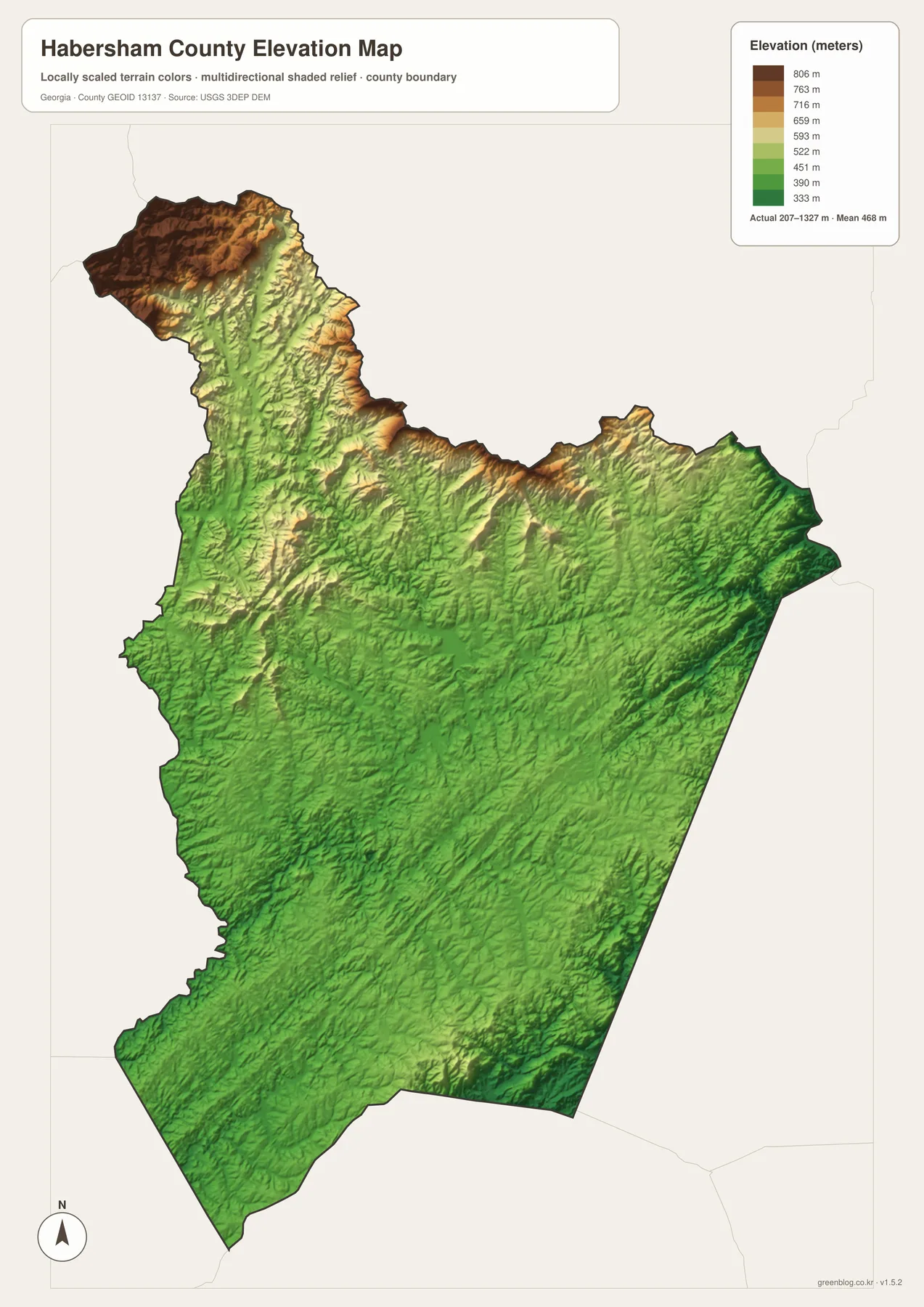
The supplied elevation map gives Habersham County an actual range of approximately 207 to 1,327 meters, with a mean of 468 meters. A difference of more than 1,100 meters separates the lowest and highest mapped terrain. Dark browns dominate the far northwest and other high northern ridges, while the central and southern portions become progressively greener. Cornelia, Baldwin, and the lower road corridor sit in terrain that is dramatically lower than the mountain crest zones at the top of the county.
The northern relief is not one broad high plateau. Long ridges are separated by narrow green valleys that descend toward the county interior. Those lower cuts align with the dense stream network on the water map, showing why so many tributaries begin in the same high region. The Tallulah Falls side is also strongly dissected, with rugged slopes and narrow valleys creating a much sharper texture than the southern city corridor.
The Clarkesville–Demorest–Cornelia area is lower but still rolling. Short ridges and creek valleys repeat between the communities, and the southeastern side contains additional higher ground along the county edge. Routes 23 and 441 run through a part of the county that is much less elevated than the highest northwestern mountains. This terrain contrast helps explain why the main urban and transportation corridor is concentrated in the central and southern section rather than spread evenly through the northern high country.
The relief colors are designed for broad comparison across the county, not for determining the exact elevation of a building lot, road project, or drainage design. Site-level work requires finer elevation data and, when appropriate, field measurements. For classroom geography, county profiles, or presentations, however, the 207–1,327 meter range provides an unusually clear way to show the transition from lower southern communities into much higher northern mountain terrain.
Connecting the Clarkesville Corridor with the High Mountain North
The source article in the package states that Habersham County was established in 1818 and describes mountain scenery, rivers, access to Tallulah Gorge, agriculture, healthcare, and small colleges as parts of its local background. The map set here does not attempt to measure those economic or institutional subjects. Instead, it supplies the geography beneath them: Clarkesville as the county seat, a cluster of cities from Demorest to Baldwin, Tallulah Falls on the eastern mountain side, a dense stream network, and a north-to-south elevation difference exceeding 1,100 meters.
For a basic location or road reference, the general county map is the most useful starting point. The ranked city view is cleaner when the question is how Cornelia, Baldwin, Demorest, Clarkesville, Mount Airy, and Tallulah Falls are distributed. The water map is better for the Soquee River, Big Panther Creek, Deep Creek, Beaverdam Creek, Hazel Creek, and named lakes. The elevation map provides the clearest explanation of why the northern county feels so different from the central-southern settlement corridor.
Clarkesville is especially useful for tying the four views together. Routes 197 and 385 meet the broader road network around the county seat; Demorest and Cornelia lie close to the south; streams descend through the surrounding valleys; and the terrain rises sharply toward the north. Reading those relationships together turns the maps into more than separate illustrations. They show how roads, settlement, water, and relief occupy different parts of the same mountain county.
Frequently Asked Questions
Is the county seat the largest city on the ranked map?
No. Clarkesville is the county seat, while Cornelia has the largest displayed value on the supplied city map at 4,992. The map ranking and the county’s administrative role are different pieces of information.
Which six cities are ranked on the city view?
The map ranks Cornelia, Baldwin, Demorest, Clarkesville, Mount Airy, and Tallulah Falls. The more detailed general map also includes additional place labels such as Alto and Raoul.
How large is the county’s elevation range?
The elevation view reports an actual range of about 207 to 1,327 meters and a mean of 468 meters. The highest terrain is concentrated mainly in the northern and northwestern mountains, well above the southern city corridor.
What is inside the A3 map archive?
The archive provides four large JPG originals covering the county reference, six-city distribution, water network, and elevation. Keeping the subjects in separate files makes roads, city names, streams, and relief easier to read when printed or placed in a document.
Map File Information
Habersham County A3 Map Files
- Included Files: 4 high-resolution A3 JPG map files shown in this article
- File Type: JPG files in a ZIP archive
- Intended Use: Printing, education, presentations, and map-based projects
Related Maps
Habersham County Data and Reference Sources
- U.S. Census Bureau QuickFacts: Habersham County – current official county statistics
- New Georgia Encyclopedia: Habersham County – county history and regional background
- Census TIGER/Line boundary resources – reference geometry for Habersham County and neighboring counties
- USGS hydrography resources – reference data for the Soquee River, creeks, lakes, and other mapped waters
- USGS 3DEP elevation resources – source elevation data for comparing the 207–1,327 meter terrain range
Green Map creates custom-edited map images using open geographic data sources such as geoBoundaries, Natural Earth, OpenStreetMap, and government open data. These maps are edited visual materials, not raw data files, and are provided for education, documents, presentations, and graphic reference.