Gwinnett County is a heavily settled part of metropolitan northeastern Georgia, but the supplied maps show much more than a dense field of city names. Peachtree Corners, Duluth, Lawrenceville, Sugar Hill, Suwanee, and Snellville are the six cities ranked on the simplified city view, while the general map adds places such as Norcross, Berkeley Lake, Buford, Dacula, Grayson, Lilburn, Braselton, and Mulberry. Beneath that settlement pattern is a branching water system that includes the Chattahoochee River, Suwanee Creek, Yellow River, Alcovy River, Apalachee River, and Little Mulberry River. The elevation view ranges from about 102 to 391 meters, showing that the county’s northern hills and southern stream valleys remain important even within a highly developed landscape. Four high-resolution A3 JPG versions of the maps are available together in the downloadable ZIP.
Lawrenceville works well as a central reference because it sits between the dense western cities, the northern Suwanee–Sugar Hill area, and the eastern communities around Dacula and Mulberry. Peachtree Corners and Norcross are near the western edge, Duluth and Berkeley Lake lie just to their northeast, and Buford appears near the northern side. Snellville and Grayson provide southern references. When the county map is replaced by the water or relief view, those same urban areas are divided by low green valleys and higher rolling ground rather than highways and place labels. That contrast is the main reason the four-map set is useful: it separates settlement, city ranking, water, and terrain without losing the common county outline.
Table of Contents
Lawrenceville Between the Western Cities and the Northern Corridor
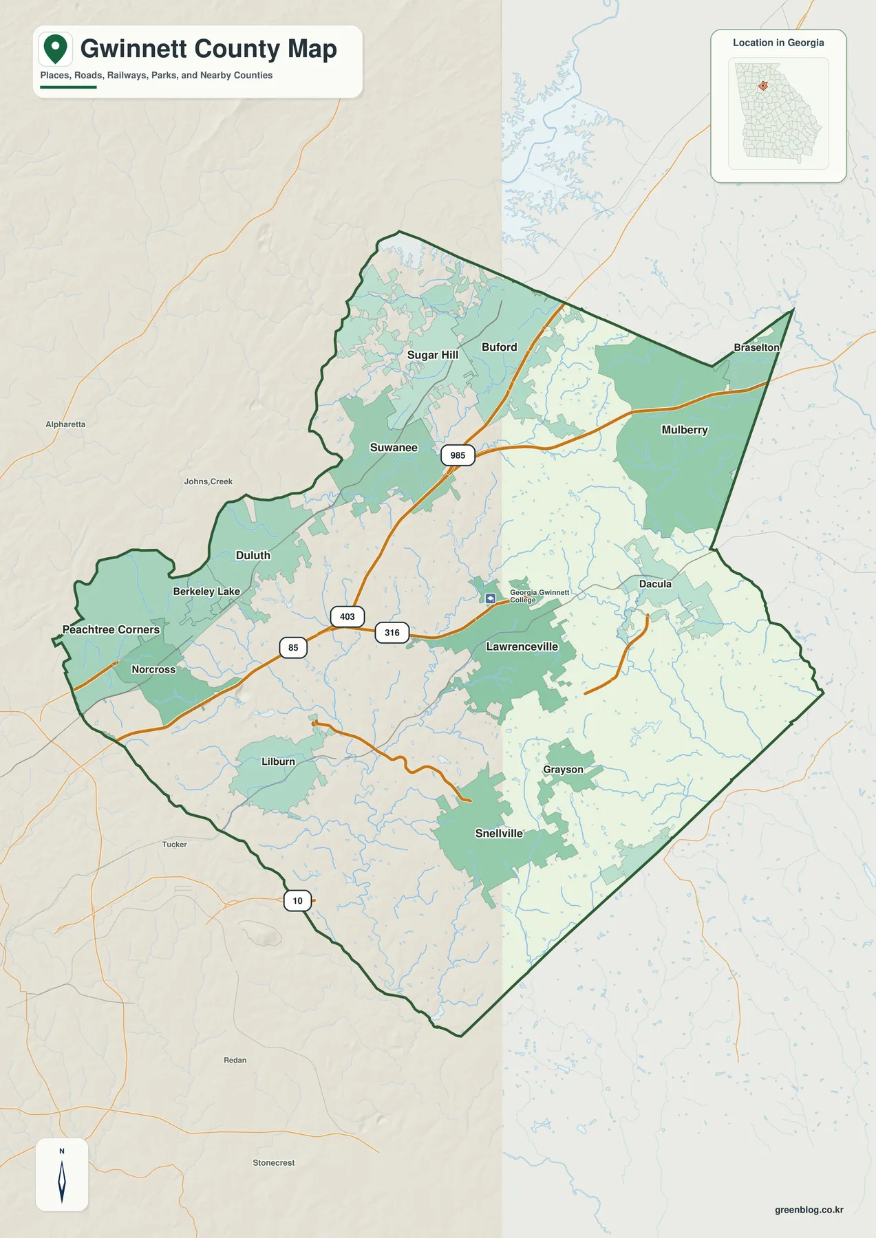
The general map shows several strong transportation references. Road labels 85 and 403 appear through the western-central part of the county, 985 continues north, 316 runs eastward through the Lawrenceville side, and 10 is visible close to the southern edge. The purpose here is not turn-by-turn navigation; the road network instead provides a framework for seeing how Peachtree Corners, Norcross, Duluth, and Suwanee connect toward Lawrenceville and how the county continues toward Dacula in the east and Snellville in the south.
The western side contains the tightest cluster of named cities. Peachtree Corners and Norcross sit near the county edge, Berkeley Lake and Duluth lie just to the northeast, and Suwanee forms the next major reference farther north. Sugar Hill and Buford occupy the upper part of the map. Lawrenceville is positioned farther east of that cluster, and Georgia Gwinnett College is labeled just north of the city. This arrangement makes the county look less like one city surrounded by suburbs and more like a chain of distinct urban centers spread across several directions.
The eastern and southern place labels broaden that picture. Dacula and Mulberry sit east and northeast of Lawrenceville, Braselton appears near the pointed northeastern edge, Grayson and Snellville occupy the southern side, and Lilburn lies toward the southwest. Outside the county, labels such as Alpharetta, Johns Creek, Tucker, Redan, and Stonecrest provide additional metropolitan orientation. The map is therefore most useful for county-scale place and road context; local addresses and real-time traffic still require a dedicated navigation source.
Six Ranked Cities Across a Much Larger Urban County
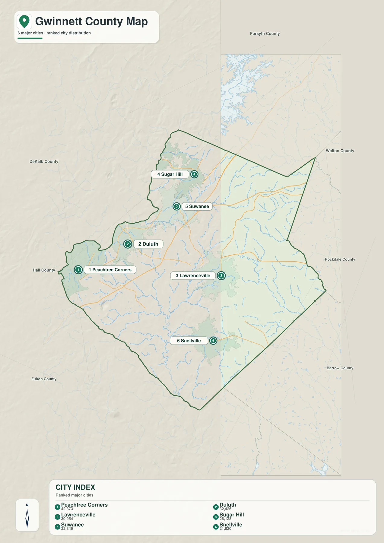
The city map intentionally reduces the number of labels. Its CITY INDEX ranks Peachtree Corners at 42,373, Duluth at 32,426, Lawrenceville at 30,954, Sugar Hill at 26,128, Suwanee at 22,349, and Snellville at 21,620. These are the figures printed on the supplied city graphic and are included to explain that map’s ranking. They are not newly verified population estimates for this article; current official demographic figures should be checked through the Census source in the reference section.
The spatial arrangement tells a different story from the numbers. Peachtree Corners and Duluth are on the western side, Sugar Hill and Suwanee are farther north, Lawrenceville sits in the central-eastern interior, and Snellville marks the south. The six labels therefore span much of the county instead of forming one compact cluster. The general map adds several other named places, so the ranked view should be understood as a selective comparison of major cities rather than a complete municipal inventory.
That distinction matters because the old title emphasized seventeen municipalities, while the supplied city graphic itself is explicitly labeled as a six-major-city ranked distribution. Norcross, Berkeley Lake, Buford, Dacula, Grayson, Lilburn, Braselton, and Mulberry remain visible on the county map and provide useful local references. Using the two maps for their intended purposes avoids turning the city view into a claim about every incorporated or unincorporated place in Gwinnett County.
| Map rank | City | Displayed value | General position |
|---|---|---|---|
| 1 | Peachtree Corners | 42,373 | western side |
| 2 | Duluth | 32,426 | west-northwest |
| 3 | Lawrenceville | 30,954 | central-east |
| 4 | Sugar Hill | 26,128 | north |
| 5 | Suwanee | 22,349 | north-central |
| 6 | Snellville | 21,620 | south |
From the Chattahoochee River to the Yellow, Alcovy, and Apalachee Valleys
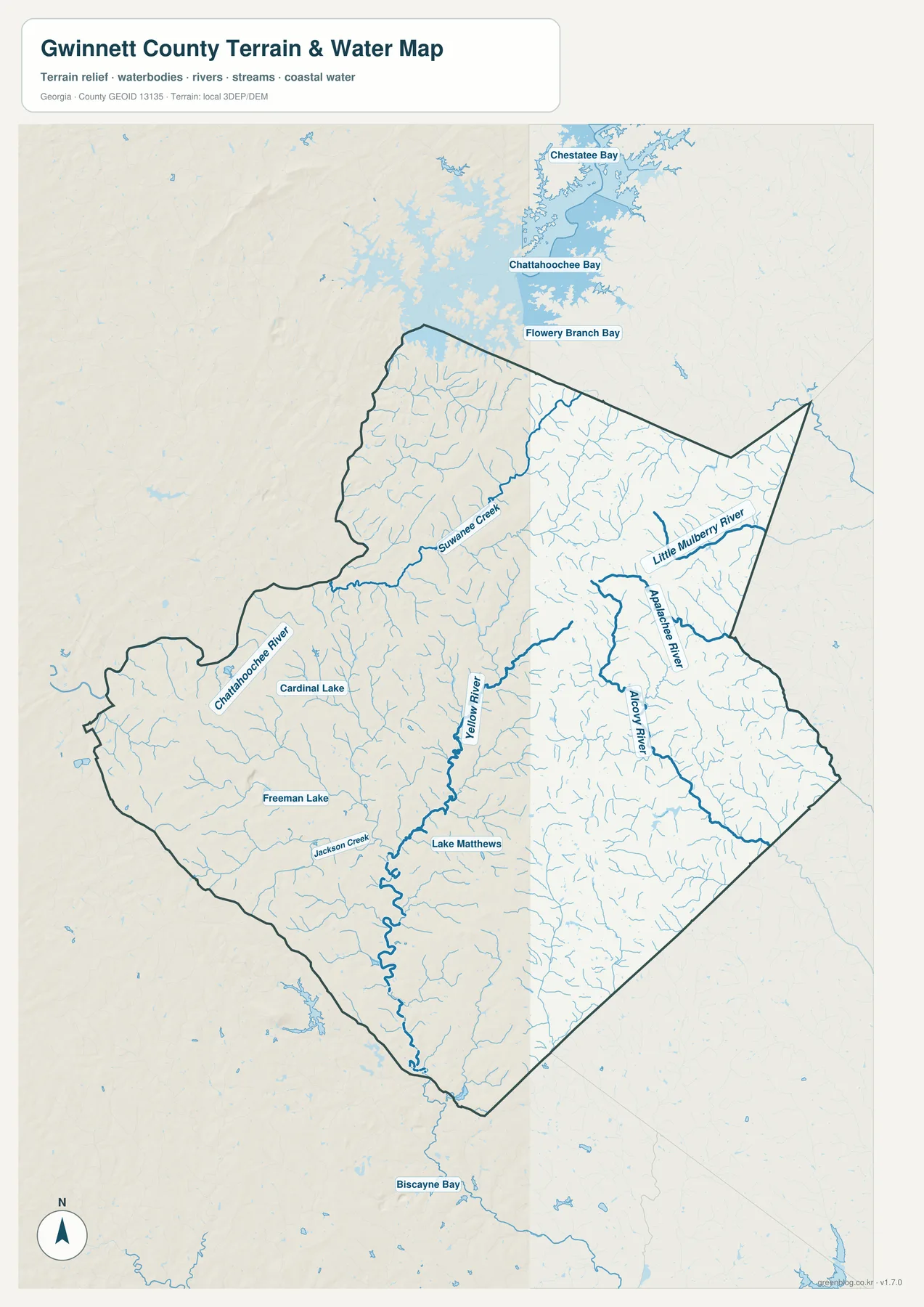
The Chattahoochee River provides the strongest water reference on the western side. It follows the county edge near the Peachtree Corners–Duluth side, while Suwanee Creek approaches from the north-central interior. Cardinal Lake and Freeman Lake are labeled nearby. The water map strips away the dense urban labeling and makes it easier to see that the western cities occupy terrain divided by river and creek valleys rather than one continuous developed surface.
Farther inside the county, the Yellow River is a prominent north-south channel through the central and southern area. Jackson Creek joins the southwestern side of that network, and Lake Matthews appears to the east. The eastern half is divided again: the Alcovy River follows a long route toward the southeast, the Apalachee River occupies a separate eastern corridor, and the Little Mulberry River provides another named channel in the northeast. The result is a county whose drainage spreads toward several different river systems rather than funneling through one dominant stream.
Those waterways provide useful context for the city map. Suwanee and Sugar Hill are close to the Suwanee Creek network, Lawrenceville sits between the Yellow and Alcovy sides of the county, and Dacula is closer to the Apalachee–Alcovy drainage area. Snellville lies near the southern Yellow River system. These are county-scale relationships rather than site-specific drainage claims, but they help explain why the elevation map contains so many green valley bands cutting through otherwise rolling terrain.
The water graphic should be used as a geographic reference, not as a flood-insurance, parcel, depth, or legal-access map. Property-level water questions require the appropriate current agency or local records. For this page, the important comparison is simply where the Chattahoochee, Suwanee Creek, Yellow, Alcovy, Apalachee, and Little Mulberry channels sit and how they divide the county into separate valleys.
Elevation from About 102 to 391 Meters
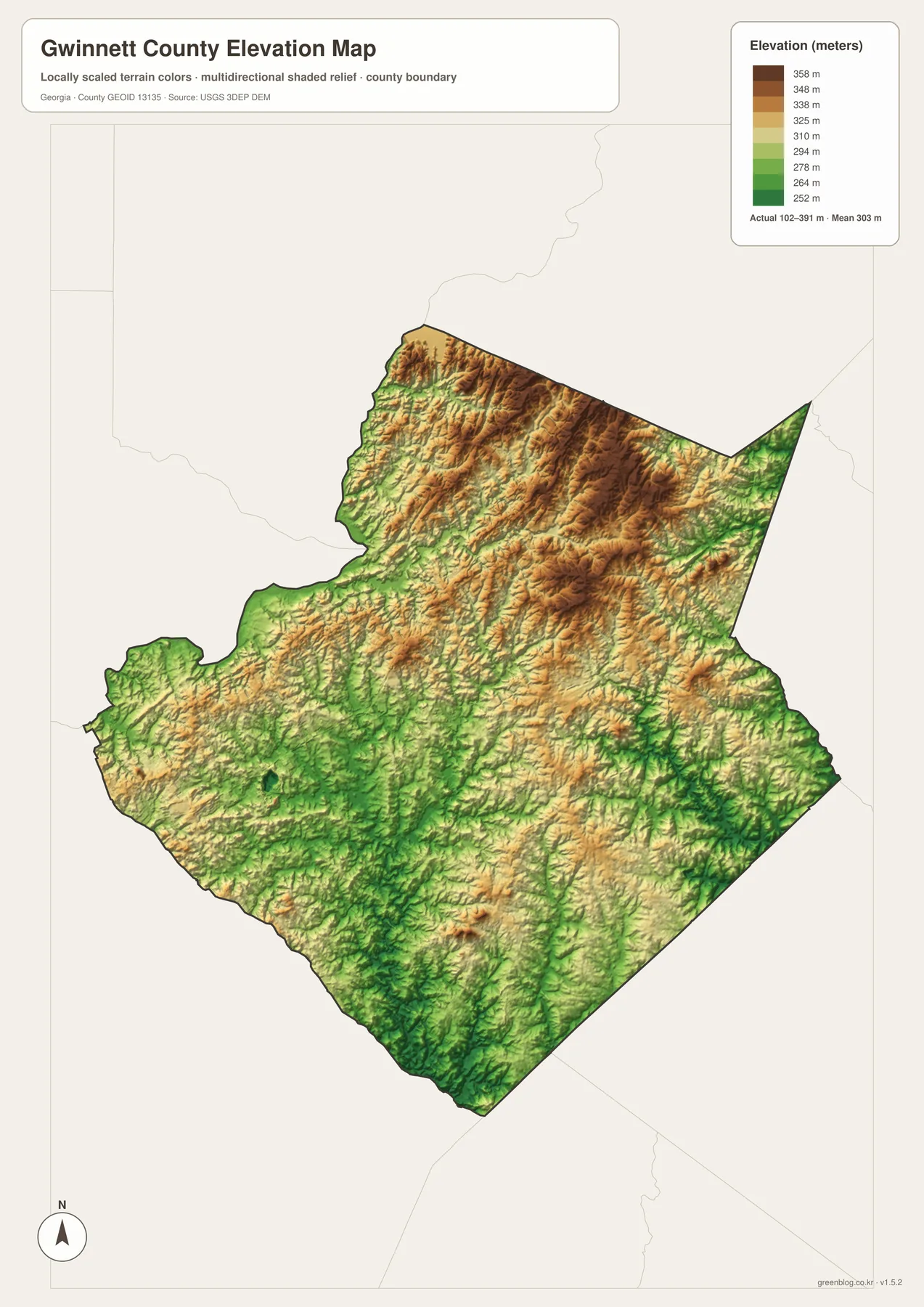
The supplied relief map spans roughly 102 to 391 meters, with a mapped mean of 303 meters. Higher tan and brown terrain dominates much of the north and northeast, and several long ridges run diagonally through the interior. Green lowlands become more common toward the south and southwest. Stream corridors also cut narrow low bands through higher ground, so the county does not simply slope in one direction.
Sugar Hill and Buford lie in a generally higher northern setting, while the Suwanee area contains more visible creek valleys. Around Lawrenceville, rolling higher ground is broken by several lower channels. South toward Snellville, green terrain becomes broader along the Yellow River and its tributaries. The Alcovy and Apalachee corridors create additional low paths across the east. Comparing those valleys with the water map makes the relief much easier to interpret than viewing the color scale by itself.
The western Chattahoochee side also contains low ground, but short ridges continue through the interior. This produces a complex mix of development and terrain: a heavily urban county still has repeated hills, stream valleys, and localized elevation changes. The map therefore works well when a classroom or report needs to show that metropolitan development has not erased the underlying topography.
The relief image is intended for broad comparison across Gwinnett County. A building lot, road project, or drainage design needs finer elevation information than this county-scale surface can provide, and field measurements may also be necessary. For general geography, the 102–391 meter range clearly distinguishes the higher northern ground from the lower river and creek corridors.
Why the Urban Map and Terrain Map Tell Different Stories
Gwinnett County is a good example of why a single county map can hide important information. The general view is crowded with city names and road corridors, which is useful for place orientation but makes the physical landscape less obvious. The city map simplifies that settlement pattern to six ranked cities. The water view removes most urban emphasis and reveals a county cut by multiple river systems, while the elevation view shows that those waterways occupy lower channels between rolling hills.
A location or transportation presentation will usually begin with the general map. A slide comparing Peachtree Corners, Duluth, Lawrenceville, Sugar Hill, Suwanee, and Snellville is clearer with the ranked city view. The water map is better for the Chattahoochee, Yellow, Alcovy, Apalachee, and Suwanee Creek systems, and the relief map is the best choice for the northern hills and southern valleys. Because the same county outline is used throughout, the images can be placed side by side without forcing every subject into one crowded graphic.
Lawrenceville provides a useful bridge among the themes. On the general map it is an important road and city reference between the western cluster and eastern communities. On the water map it sits between major interior drainage corridors, and on the elevation view it is surrounded by alternating hills and valleys rather than uniform flat terrain. That combination makes Lawrenceville a practical anchor for explaining how Gwinnett County’s settlement pattern fits into its underlying physical geography.
Frequently Asked Questions
Why does the city map rank only six cities?
The supplied city graphic is explicitly a six-major-city ranked distribution. It highlights Peachtree Corners, Duluth, Lawrenceville, Sugar Hill, Suwanee, and Snellville, while the general county map includes additional place names such as Norcross, Berkeley Lake, Buford, Dacula, Grayson, Lilburn, Braselton, and Mulberry.
Which waterways are the best orientation points?
The western Chattahoochee River, Suwanee Creek, central Yellow River, eastern Alcovy and Apalachee rivers, and northeastern Little Mulberry River are the clearest named corridors. Jackson Creek, Cardinal Lake, Freeman Lake, and Lake Matthews add smaller local references.
What elevation range is shown on the relief map?
The map reports an actual range of about 102 to 391 meters and a mean of 303 meters. The north and northeast contain more high terrain, while lower green valleys follow rivers and creeks through the southern, western, and eastern parts of the county.
What is inside the A3 download archive?
The archive contains four large JPG originals: a general county reference, the six-city distribution map, a named-waterway map, and an elevation map. Separating the subjects keeps city labels, river names, and terrain shading readable when the images are printed or placed in a document.
Map File Information
Gwinnett County A3 Map Files
- Included Files: 4 high-resolution A3 JPG maps described on this page
- File Type: JPG files in a ZIP archive
- Intended Use: Printing, education, presentations, and map-based projects
Related Maps
Gwinnett County Data References
- U.S. Census Bureau QuickFacts: Gwinnett County – current county statistics
- Census TIGER/Line boundary resources – county and neighboring-boundary geometry reference
- USGS hydrography resources – reference data for the Chattahoochee, Yellow, Alcovy, Apalachee, creeks, and lakes
- USGS 3DEP elevation resources – source elevation data for the 102–391 meter county relief range
Green Map creates custom-edited map images using open geographic data sources such as geoBoundaries, Natural Earth, OpenStreetMap, and government open data. These maps are edited visual materials, not raw data files, and are provided for education, documents, presentations, and graphic reference.