Jasper County South Carolina Map readers can use this page to move from the county’s basic road pattern to its two main city references and then to a much denser network of rivers, swamps, and coastal waters. Ridgeland sits in the east-central part of the county, while Hardeeville lies much farther south along the long lower section. The map files shown here can also be downloaded as a ZIP containing three high-resolution JPG originals, so the page works both as a quick visual guide and as a source for printable map files.
The shape of Jasper County makes the relationship between roads and water especially useful. The northern half is broad, with long stretches of county boundary and several roads crossing toward Ridgeland. The county narrows toward the south, where Hardeeville becomes the main labeled city and the boundary becomes more irregular near rivers and coastal channels. Hampton County appears to the north, Beaufort County to the east, Colleton County to the west, and Allendale County to the southwest, giving the map a clear Lowcountry frame without requiring a separate statewide locator.
Table of Contents
Ridgeland and Hardeeville define two different parts of the county
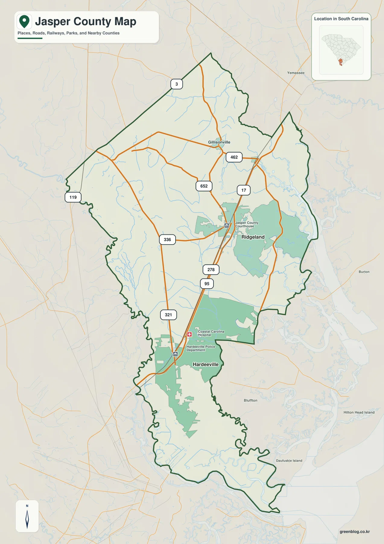
Ridgeland is the most important orientation point on the general county map. The Jasper County Courthouse is labeled there, and several numbered roads converge in or near the town. Route 17 runs through the area, while 336 and 462 cross east-west, and 652 and 278 add shorter connections around the same part of the county. This concentration makes Ridgeland easy to identify even before reading the courthouse label. It is not simply a dot near the middle of the outline; it is the place where the road pattern becomes most compact.
Hardeeville is farther south and occupies a different geographic setting. The county is narrower there, and the map shows routes 95 and 321 close to the city. Coastal Carolina Hospital and the Hardeeville Police Department are also marked, which gives the southern part of the map additional reference points. Between Ridgeland and Hardeeville, the county remains relatively open, so the two places do not read as a single continuous urban strip. The distance between them is part of what gives Jasper County its long north-south structure.
The northern edge adds another contrast. Route 3 appears near the upper boundary, 119 is labeled along the west side, and the upper outline includes a long diagonal segment before bending more sharply in the northeast. The lower boundary is much more irregular because it follows a landscape filled with channels and wetlands. Reading those two ends together is more informative than treating the county outline as an abstract shape.
A two-city pattern rather than one compact center
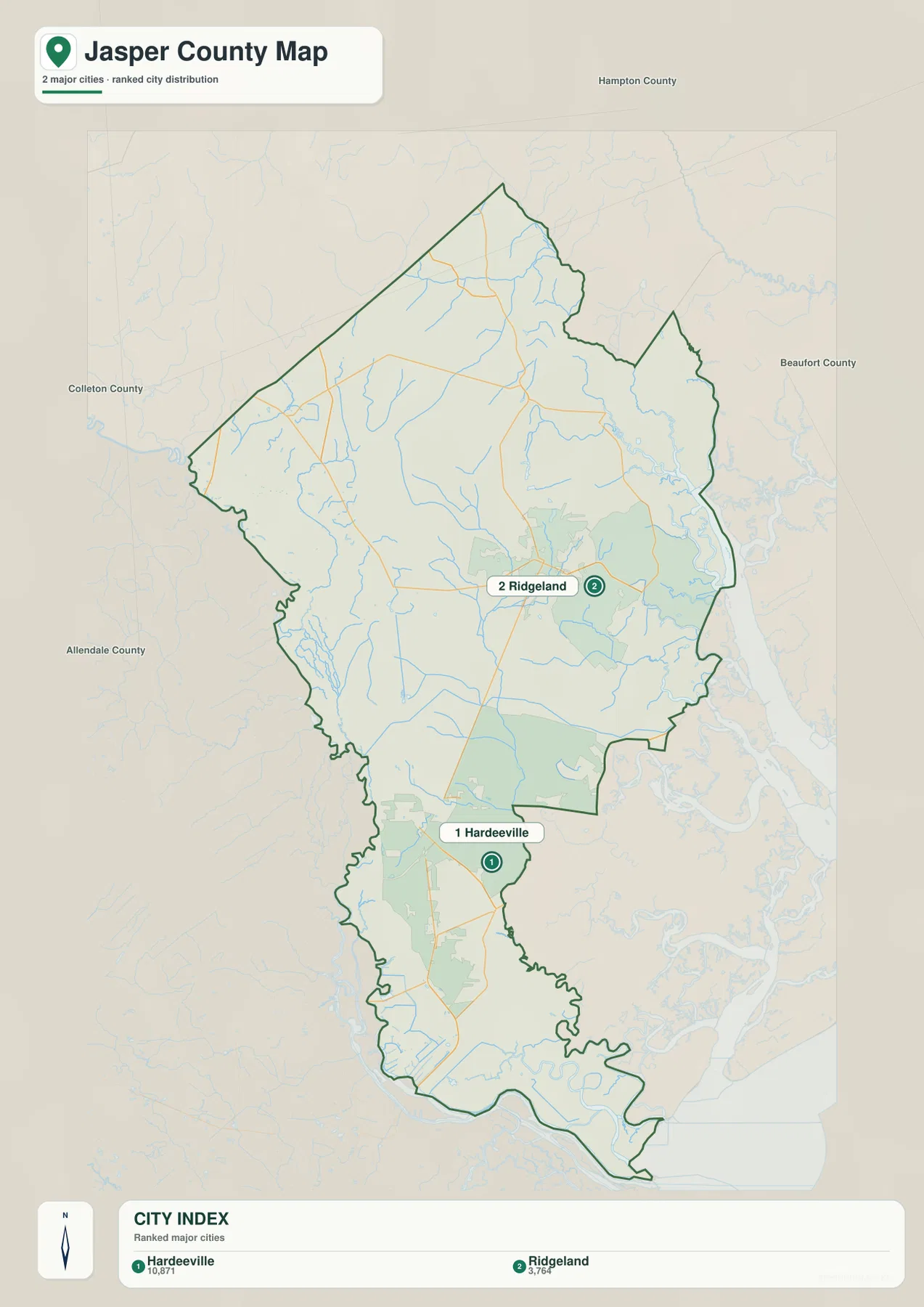
The city distribution map deliberately reduces the amount of road detail so the two major city references stand out. Its ranked index places Hardeeville first at 10,871 and Ridgeland second at 3,764. The important visual point is not only the difference between those values but also the separation between the two locations. Ridgeland sits in the east-central part of Jasper County, while Hardeeville is well to the south in the narrower lower section.
That arrangement changes how neighboring counties appear from each city. Ridgeland is closer to the broad middle of the county and faces the Beaufort County side of the map to the east. Hardeeville sits much farther south, closer to the network of waterways and the lower county boundary. Hampton County is shown above Jasper County, Colleton County to the west, and Allendale County toward the southwest. This makes the city map useful for explaining where the county’s population centers sit inside an outline that is much larger than either urban area.
The city map should not be read as a complete municipal inventory. It is a ranked major-city view designed to keep the two strongest reference points visible. For a presentation that needs a simple “Ridgeland in the middle, Hardeeville in the south” explanation, this version is cleaner than the road map. When exact route numbers or facilities matter, the general county map is the better choice.
From the Coosawhatchie River to the sounds along the southern edge
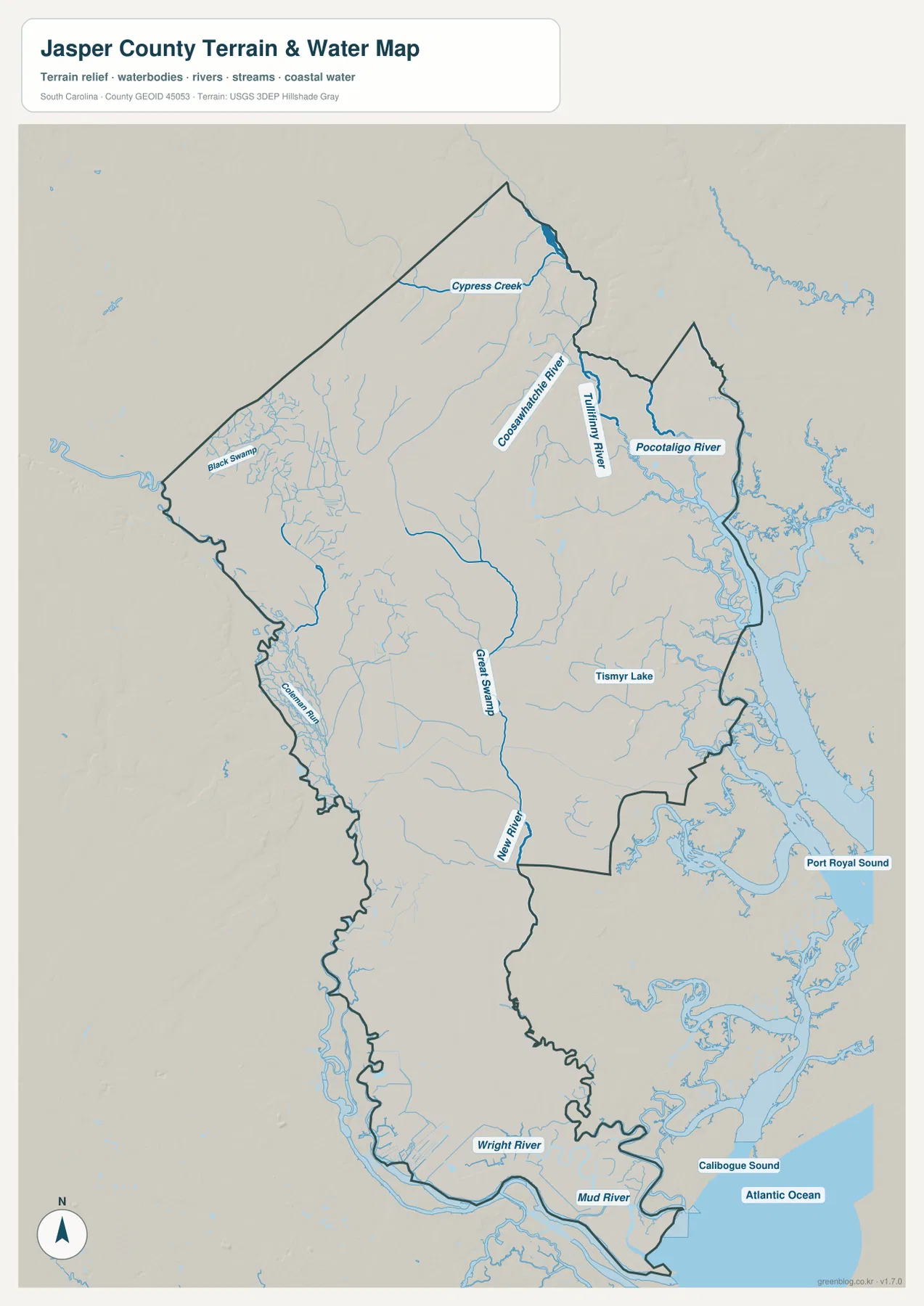
Water is the strongest geographic theme on the terrain and water map. In the north and northeast, the Coosawhatchie River is labeled near the Tullifiny River, while the Pocotaligo River appears farther east. Cypress Creek crosses the upper part of the county, and Black Swamp is labeled to the west. These names show that the county’s drainage pattern is not confined to one main river. Several river and swamp systems enter different parts of the outline before the map reaches the coastal lowlands in the south.
The middle and southern sections become even more intricate. Great Swamp runs down the central portion of the map, New River is labeled farther south, and Wright River and Mud River appear near the lower edge. Outside the county to the east and southeast, Port Royal Sound and Calibogue Sound are labeled, with the Atlantic Ocean beyond them. The southern outline therefore looks very different from the straighter upper boundary: it bends around a landscape where rivers, marsh-like channels, and coastal water are visually dominant.
This is a reference map of terrain and water, not a flood-risk map, navigation chart, parcel map, or engineering survey. It does not provide water depth, tidal stage, flood frequency, ownership boundaries, or a route suitable for boating. Its value is simpler and more visual: it shows which named rivers, swamps, and coastal waters are close to each other and how the southern part of Jasper County is much more water-defined than the northern road-oriented part.
Why roads and waterways tell different stories about the same boundary
The three maps are most useful when they are compared rather than read in isolation. Around Ridgeland, the general map emphasizes a compact group of roads: 17, 336, 462, 652, and 278 are all visible in or near the same area. Around Hardeeville, 95 and 321 are more prominent, giving the southern city a simpler north-south road structure. The water map removes much of that road emphasis and reveals how many streams and swamp channels occupy the spaces between and around those city corridors.
The neighboring-county labels add another layer. Hampton County lies to the north, Beaufort County to the east, Colleton County to the west, and Allendale County toward the southwest. The eastern and southern sides are visually more entangled with waterways, while parts of the northwestern boundary are comparatively straight. That contrast helps explain the county outline more effectively than a generic statement that Jasper County is in southern South Carolina.
Choosing the clearest version for the job
Use the general county map when you need roads, Ridgeland and Hardeeville, the county courthouse area, selected facilities, and neighboring places in one view. Use the city distribution map when the main question is where the two major city references sit inside the county and how far apart they are. Use the terrain and water map when rivers, swamps, coastal channels, and the relationship to Port Royal Sound or Calibogue Sound are the subject. Each map answers a different practical question, so there is no need to force all three layers into one crowded graphic.
For on-screen reading, the WebP previews on this page are the quickest option. For printing, reports, classroom handouts, or presentation slides, the ZIP provides the matching high-resolution JPG originals. The archive contains one general county map, one city distribution map, and one terrain-and-water map, allowing you to keep only the version that fits your project or use all three together.
Frequently Asked Questions
Is Ridgeland or Hardeeville the main center of Jasper County?
Ridgeland is the county seat, and the general map marks the Jasper County Courthouse there. It also has a dense cluster of numbered roads around it. The city distribution map, however, ranks Hardeeville first and Ridgeland second. For administrative orientation, Ridgeland is the key reference; for the major-city pattern, both places matter because they occupy different parts of the county.
Which waterways are easiest to identify on the Jasper County water map?
The north and northeast show the Coosawhatchie River, Tullifiny River, Pocotaligo River, and Cypress Creek, while Great Swamp and New River extend through the middle and south. Near the lower edge, Wright River and Mud River are labeled, with Port Royal Sound and Calibogue Sound nearby. The map is intended for geographic orientation, not for flood prediction or marine navigation.
Map File Information
The ZIP contains high-resolution JPG originals for the Jasper County general map, city distribution map, and terrain-and-water map.
- Included Versions: county map, city distribution map, terrain-and-water map
Related Maps
Sources and references
- South Carolina Association of Counties – County Information: county seat, population, land area, and county reference information
- SCAC County Directory Pages: county founding and administrative reference
- U.S. Census Bureau TIGER/Line Shapefiles: county boundary and geographic reference data
- USGS National Hydrography: river and hydrography reference data
Green Map creates custom-edited map images using open geographic data sources such as geoBoundaries, Natural Earth, OpenStreetMap, and government open data.
These maps are edited visual materials, not raw data files, and are provided for education, documents, presentations, and graphic reference.