Bullock County sits in southeastern Alabama, with Union Springs serving as the county seat and the clearest reference point for understanding the area. This page separates the county into four practical map themes—roads and boundaries, highlighted communities, waterways, and elevation—so the details remain readable instead of competing on one crowded sheet. High-resolution A3 JPG versions of all four maps are available in one ZIP download, making the set useful for printing, classroom work, presentations, and general location reference.
The county looks relatively open on a basic transportation map, but switching between the sheets reveals much more structure. Roads converge around Union Springs and continue toward neighboring counties, Midway provides a useful southeastern reference point, numerous creeks cross the rural interior, and the terrain rises and falls through a broad range of roughly 66 to 202 meters. Looking at these features separately makes Bullock County easier to understand than trying to read every layer at once.
Table of Contents
Start with Union Springs, county boundaries, and the main roads
Union Springs is the best place to begin on the county map. It lies near the central part of Bullock County and acts as a visual anchor for the road network around it. US 82 provides an important east-west route, while roads associated with the 29 corridor help establish north-south orientation. Additional route numbers, including 110, 197, 114, 31, 14, 15, 223, and 239, show how smaller rural areas connect back to the main network and how traffic can continue toward adjacent counties.
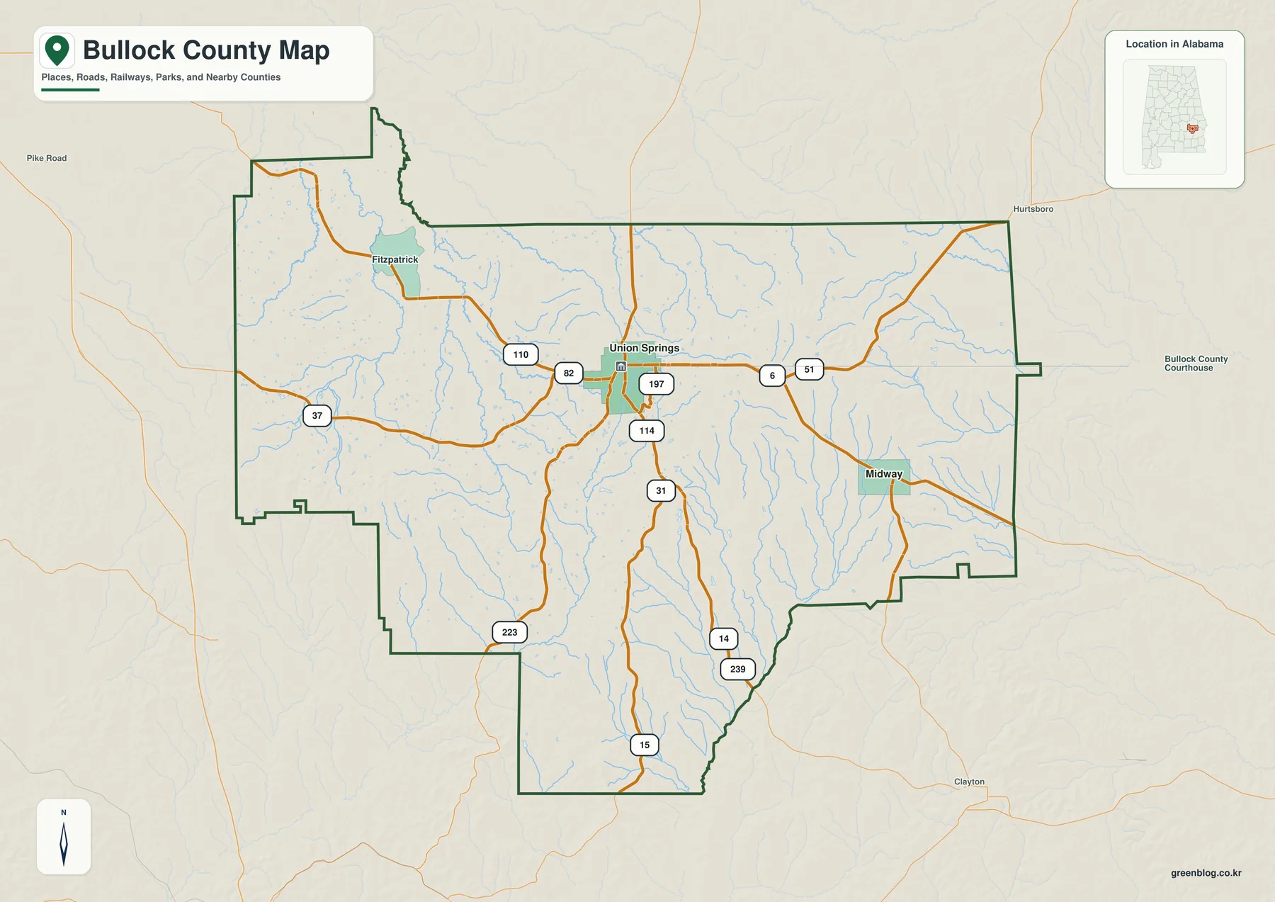
Midway appears in the southeastern part of the county, while Fitzpatrick is shown toward the northwest. The surrounding county boundaries also help explain Bullock County’s regional setting: Montgomery County lies to the west, Macon County to the north, Russell and Barbour counties to the east, and Pike County toward the southwest. These relationships matter when a road crosses the county line, because the map makes it easier to see whether a route remains local or continues into a neighboring jurisdiction.
For a reader trying to place an address or rural community in a broader context, this sheet is usually the most useful starting point. It combines the outline of Bullock County with enough road information to establish direction without adding every stream and terrain detail. It is still a reference map rather than a turn-by-turn navigation product, so current driving directions should be checked with an up-to-date road or navigation source.
Compare Union Springs and Midway without the road clutter
The city map removes much of the transportation detail and emphasizes two reference communities instead. Union Springs sits near the middle of the county, while Midway is positioned farther southeast. Seeing both on the same county outline provides a quick sense of separation between the central seat and the southeastern part of Bullock County, which can be useful when explaining the county in a presentation or introducing its geography to students.
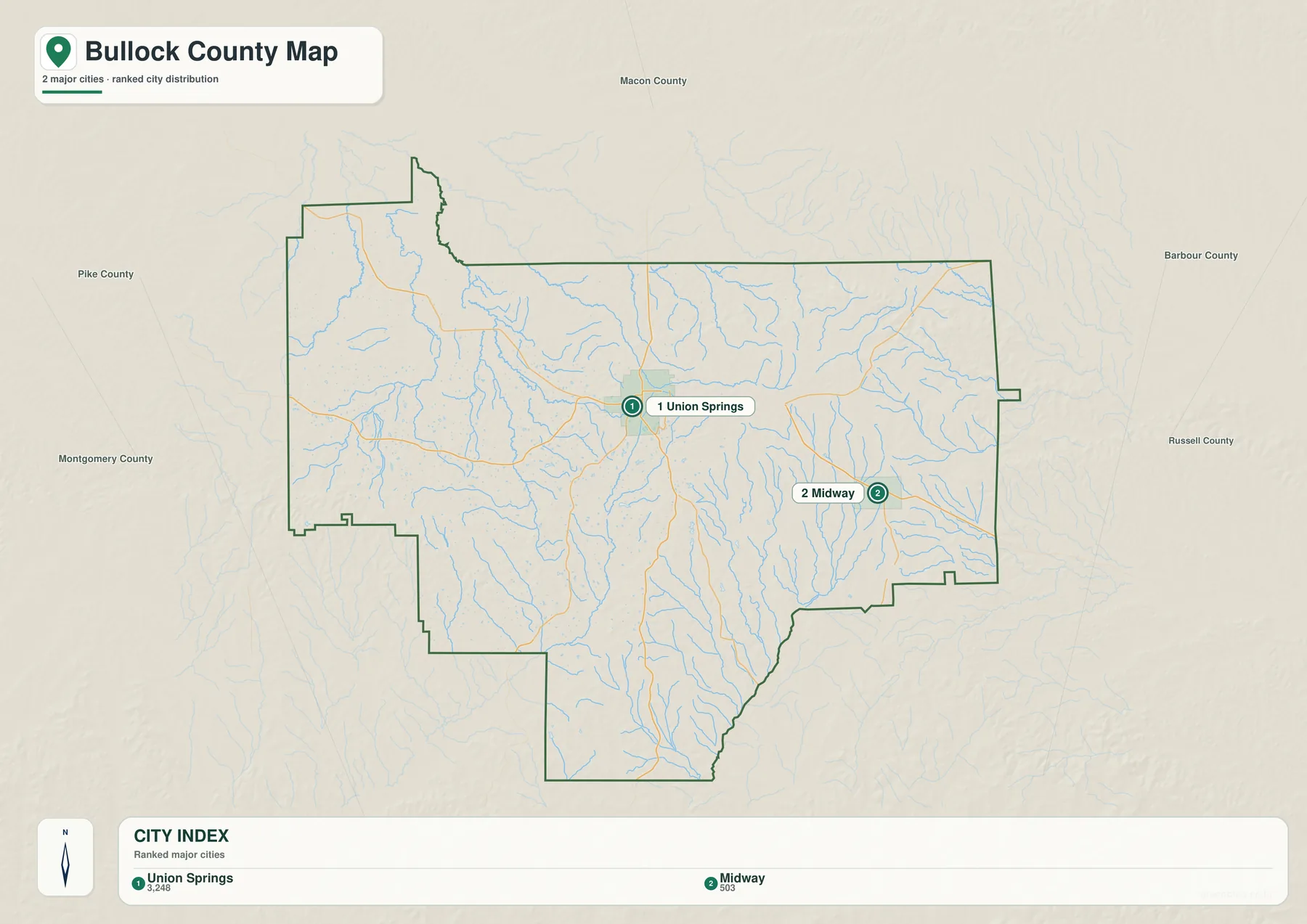
Only highlighting these two places does not mean Bullock County contains no other communities. The purpose of the sheet is simplicity: it gives readers a clean way to compare representative locations at county scale. Smaller places, detailed road connections, and driving routes are better checked on the main county map or with a current local road source.
Follow Pea River, Conecuh River, and the smaller creeks
The water map changes the impression of the county immediately. Areas that appear almost empty on the road sheet contain a dense network of creeks and tributaries. Pea River is prominent in the southeastern part of the county, while Conecuh River appears toward the southwest. Between them, named streams such as Line Creek, Bigall Creek, Old Town Creek, and Panther Creek cross different sections of the rural landscape.
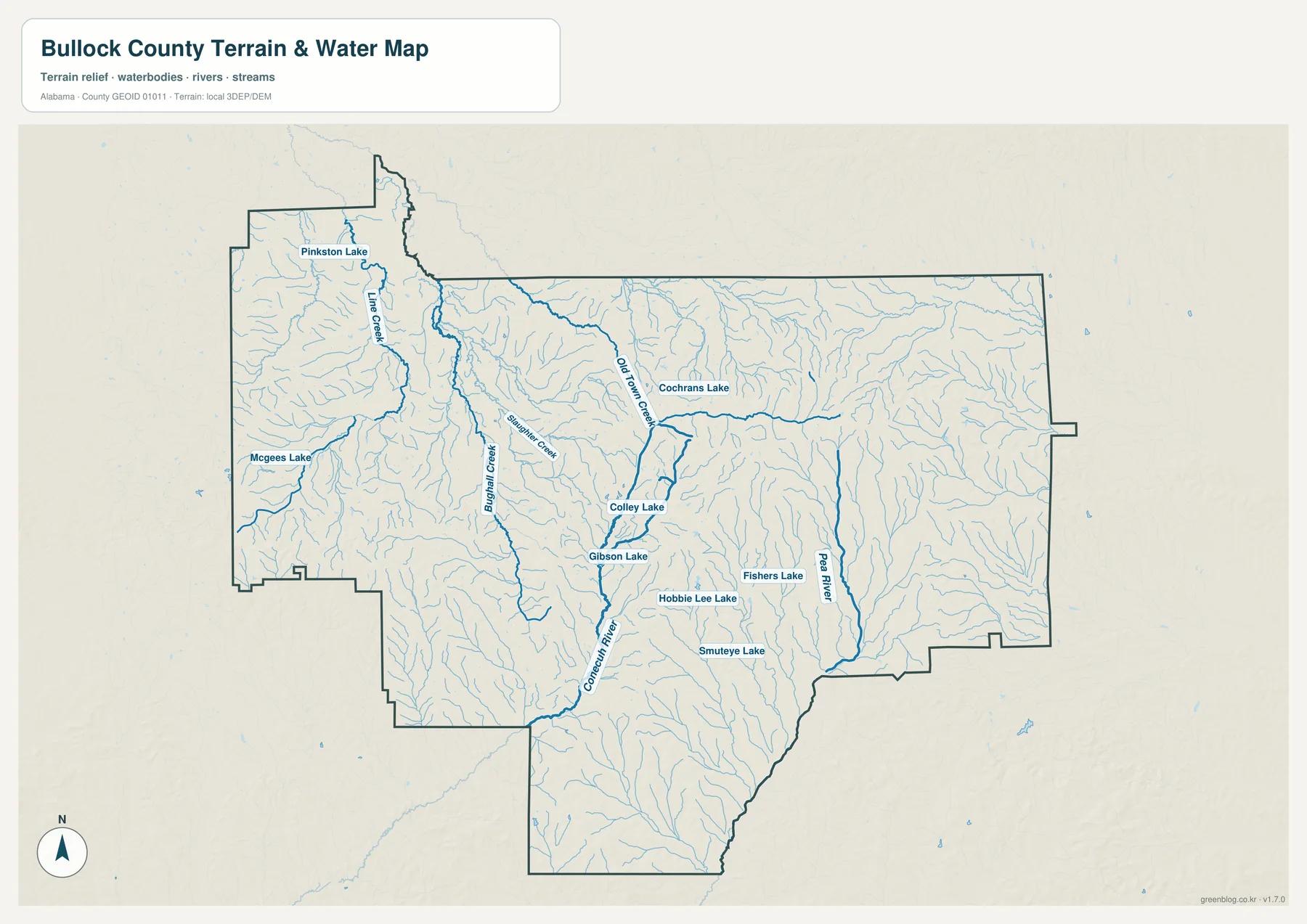
Several named lakes also provide recognizable reference points. Pinkston Lake appears in the northwestern area, McGees Lake farther west, and the map also labels Cochrans Lake, Colley Lake, Gibson Lake, Fishers Lake, Hobbie Lee Lake, and Smuteye Lake. These labels are useful for geographic orientation, but they do not indicate public ownership or guaranteed access. A lake shown on the map may be privately controlled, so fishing, boating, shoreline access, and current site conditions should be confirmed separately before visiting.
This sheet should not be treated as a flood-risk map or a legal definition of water boundaries. Its purpose is to show where rivers, creeks, and named water bodies lie within Bullock County. Property drainage, flood exposure, wetland regulation, and legal boundary questions require the appropriate official datasets and, in some cases, professional review.
See the rolling terrain across roughly 66 to 202 meters
Bullock County is not uniformly flat, and the elevation map makes that clear. The displayed range runs from about 66 meters to about 202 meters. Lower ground appears in green tones, while yellow and brown areas mark progressively higher terrain. Broad lower areas are visible in parts of the west and northwest, whereas more elevated rolling ground becomes noticeable through central, eastern, and southern sections.
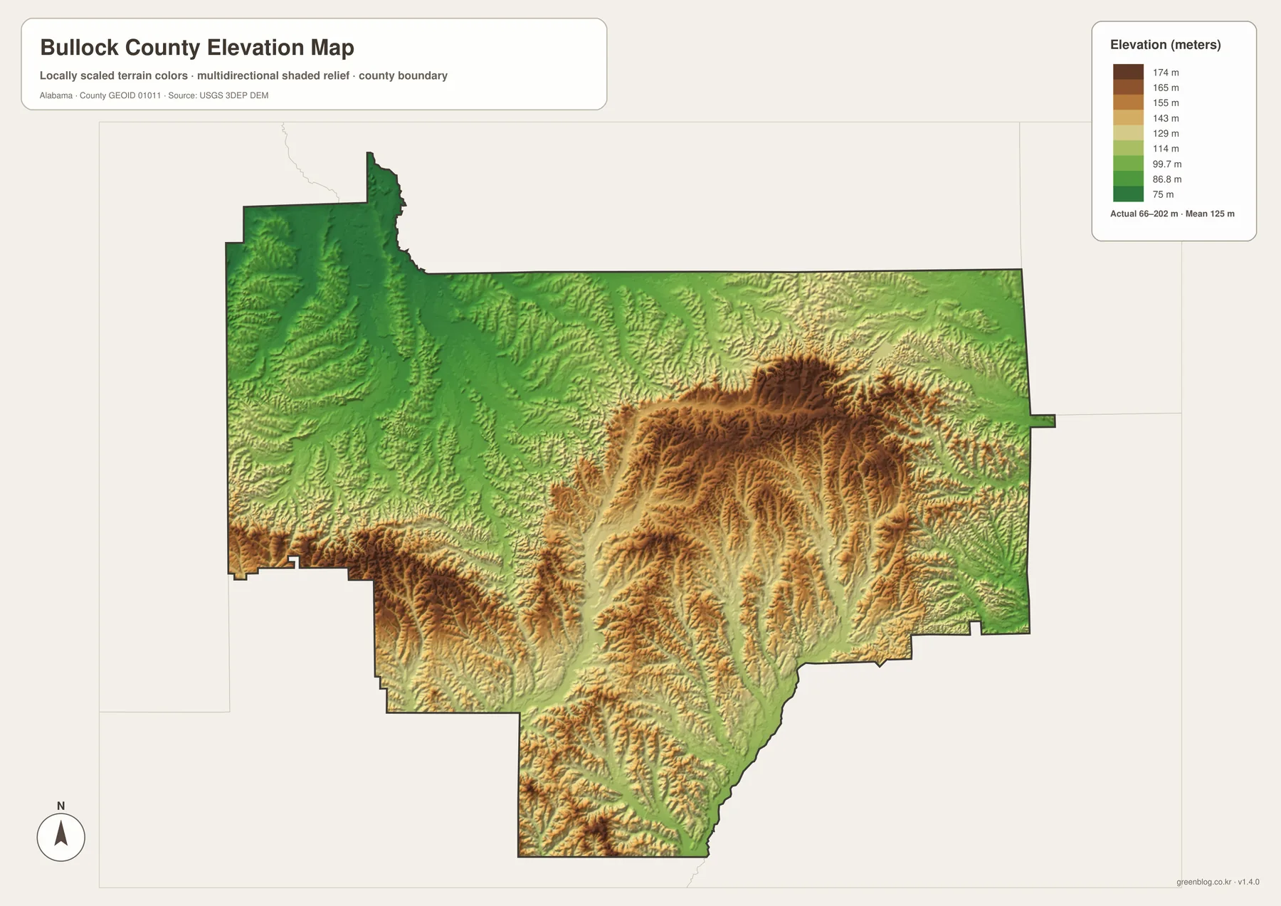
Comparing this sheet with the water map is especially helpful. Many creeks occupy lower corridors between higher ridges, so the relationship between drainage and terrain becomes easier to recognize when the two maps are viewed side by side. The long southern extension of the county shows repeated ridges and valleys particularly well, giving the relief map more texture than a standard road map can show.
The elevation sheet is intended for broad countywide comparison, education, and print use. It is not survey-grade data and should not be used to determine the exact elevation of a building site, road shoulder, or property corner. Engineering, construction, flood analysis, and legal work require authoritative site-specific measurements or official elevation data appropriate to the task.
Choose the map that matches the question
Different tasks call for different levels of detail. The county reference sheet is the clearest choice for locating Union Springs, checking the county boundary, and following major road directions. The simplified city sheet works well when only the relative positions of Union Springs and Midway matter. For natural features, the water map reveals a much denser landscape of rivers, creeks, and lakes, while the elevation map adds the hills and lower valleys that help explain where many of those streams run.
This separation also makes the files easier to use in classrooms and presentations. A lesson about transportation can stay focused on the road map without hydrography obscuring labels. A discussion of the natural landscape can pair the water and elevation sheets, allowing students to compare creek corridors with lower terrain. For printing, each JPG stands on its own, so there is no need to print information that is not relevant to the task.
The downloadable archive contains four high-resolution A3 landscape JPG files covering the county, cities, water, and elevation. They are packaged together in one ZIP, so readers can keep the complete set and select the most useful sheet later rather than downloading each map separately.
Frequently Asked Questions
Why are Union Springs and Midway the main places highlighted on the city map?
The city sheet is deliberately simplified so readers can compare two useful reference points at county scale. It does not imply that Bullock County has only two communities. Smaller places and detailed roads are better checked on the county map or a current local road source.
Does a lake name on the water map mean the public can enter or fish there?
No. A map label identifies a geographic feature, not its ownership or access status. Fishing, boating, shoreline access, and current site conditions should be verified separately before a visit.
Can the elevation map be used for surveying or engineering?
No. It is designed for general terrain comparison at county scale. Surveying, construction, flood analysis, and legal decisions require authoritative site-specific data and, when appropriate, professional field measurements.
What is included in the downloadable ZIP?
The archive contains four high-resolution A3 landscape JPG files: a county map, city map, water map, and elevation map. Each can be opened and used separately for printing or digital materials.
Map File Information
Bullock County map files
- Included Files: the downloadable Bullock County JPG map files shown in this article
- File Type: JPG files in a ZIP archive
- Intended Use: Printing, education, presentations, and map-based projects
Related Maps
Bullock County and mapping references
The following sources provide additional local background and authoritative context for roads, hydrography, and elevation.
- Bullock County official About page — county government and local background.
- Encyclopedia of Alabama: Bullock County — county history and regional context.
- ALDOT Bullock County Highway Functional Classification System — official road-reference material.
- USGS National Hydrography — official information about national hydrography data.
- USGS 3D Elevation Program — official information about national elevation data.
Green Map creates custom-edited map images using open geographic data sources such as geoBoundaries, Natural Earth, OpenStreetMap, and government open data. These maps are edited visual materials, not raw data files, and are provided for education, documents, presentations, and graphic reference.