Crenshaw County sits in south-central Alabama, where small towns are separated by broad rural areas rather than joined into one continuous urban strip. Luverne is the most useful starting point on the map because U.S. 331 runs north-south through the county and U.S. 29 meets the central road system nearby. From there, Rutledge lies to the west, Petrey and Glenwood occupy the eastern side, and Brantley and Dozier form a separate southern group. The four maps on this page show those settlements, the road and county-boundary pattern, a dense network of creeks and ponds, and the county’s relief. All four are also provided as high-resolution A3 JPG files in a single downloadable ZIP archive.
The maps are most useful when read together rather than as four versions of the same picture. The general county map is the quickest way to orient yourself by roads and place names. The city map simplifies the settlement pattern around six named communities. The water map brings Patsaliga Creek, Little Patsaliga Creek, the Conecuh River, and smaller water bodies forward, while the elevation map explains why many of those streams occupy long low corridors between ridges. Each view adds a different part of the county’s geography without requiring specialized GIS knowledge.
Table of Contents
Crenshaw County orientation: Luverne, roads, and neighboring counties
Crenshaw County borders Montgomery County on the north, Pike County on the northeast, Coffee County on the east, Covington County on the south, Butler County on the west, and Lowndes County on the northwest. Its outline is irregular and elongated, with a narrow northern extension and several steps along the western and southern boundary. Luverne lies near the middle of the settled road network, making it a practical reference point for locating the six neighboring counties and for understanding why the main highways converge in the central part of Crenshaw County.
U.S. 331 is the clearest north-south route on the county map. It enters through the northern section, passes Luverne, and continues toward the south. U.S. 29 approaches the Luverne area from the east and then carries the road pattern toward Brantley. The map also labels Alabama 10, Alabama 9, Alabama 141, and Alabama 15 in different parts of the county. These roads matter because the towns are not arranged around a large metropolitan center; they are linked by long rural corridors that cross forested and agricultural land, stream valleys, and county lines.
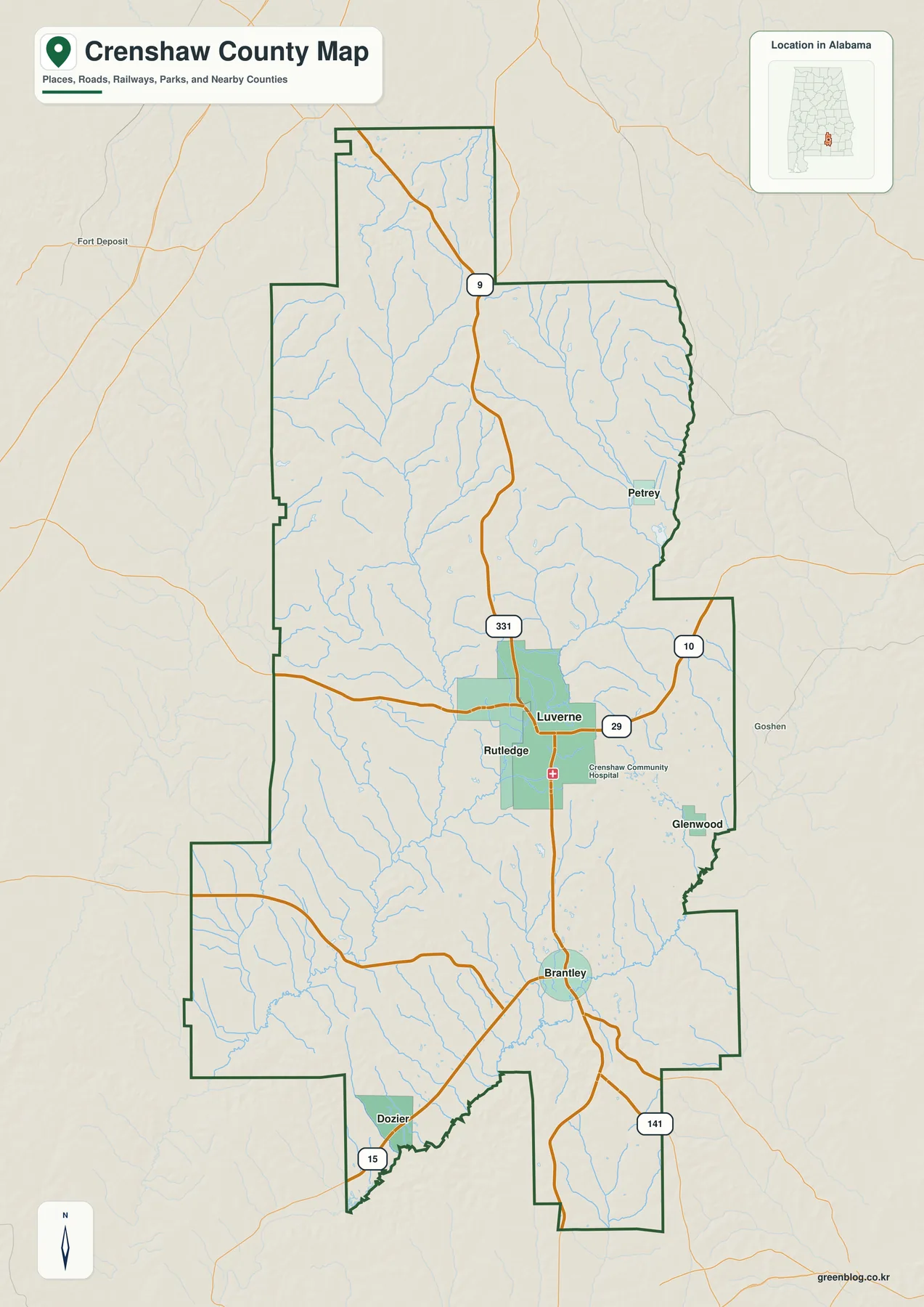
A simple way to read this map is to find Luverne first, then move outward. Rutledge is just west of the county seat. Brantley is farther south, with Dozier near the southwestern side of the southern section. Petrey is northeast of Luverne, while Glenwood is southeast toward the Pike and Coffee County side. Once those communities are in place, the road numbers become easier to follow, and the irregular county boundary no longer feels like an abstract outline.
Six communities show how settlement is spread across the county
The city map highlights six incorporated or locally important places and gives each one a ranked label. The values printed on the map are Luverne 2,694, Brantley 888, Dozier 385, Rutledge 230, Glenwood 114, and Petrey 39. The contrast is useful because it shows that even the county seat is a small town and that the remaining places are much smaller. Crenshaw County therefore makes more sense as a network of rural communities than as a single built-up population center.
Luverne and Rutledge are especially interesting as a pair. Rutledge became the first county seat in 1867, while county government moved to Luverne in 1893 after railroad-era growth strengthened the newer town. Their positions on the city map turn that history into something concrete: the old and current seats are close enough to compare directly, but Luverne is better placed on the highway network that now organizes travel through the county.
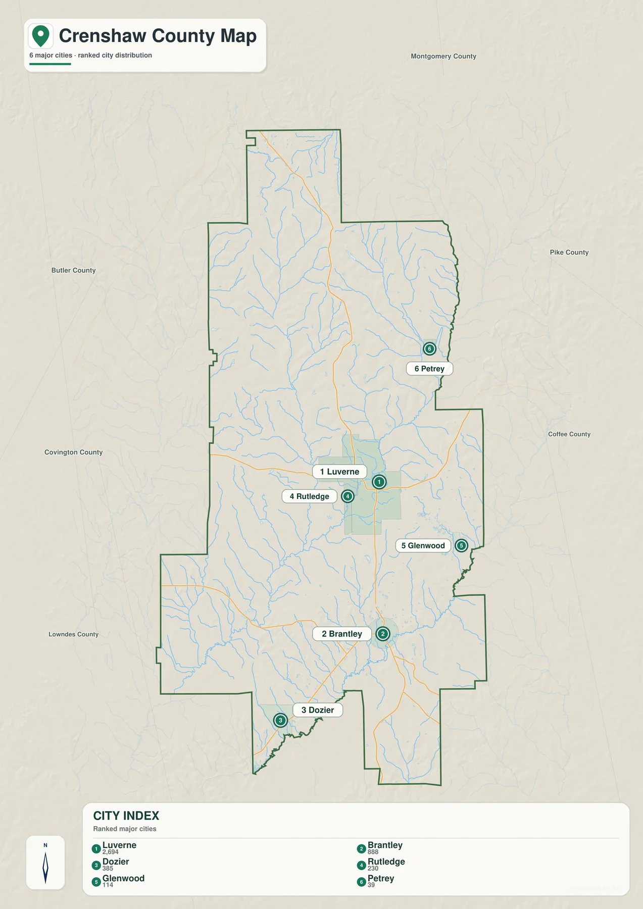
Brantley forms a second, distinctly southern center rather than an extension of Luverne. Dozier lies even farther south and west, close to the route toward Covington County. On the eastern side, Petrey and Glenwood give the Pike and Coffee County edges their own set of reference points. The map’s connector layout should be treated as a straight-line location aid, not as a road-mileage diagram. For actual travel, compare it with the general map and follow U.S. 331, U.S. 29, and the numbered state routes.
Large spaces on the city map do not mean that the rest of the county is empty. ALDOT county mapping identifies smaller localities such as Highland Home, Honoraville, Patsburg, Center Ridge, and Centenary in addition to the six emphasized communities. The simplified city map is intentionally selective: it works best for understanding where the principal settlement references sit before moving to a more detailed road source for addresses or local routes.
Patsaliga Creek and the county’s dense water network
The water map changes the visual emphasis completely. Patsaliga Creek and Little Patsaliga Creek form major named corridors through the central and western part of the county. Piney Woods Creek and Blue Creek appear in the northeastern drainage network, while Dry Creek runs through the southeast. Along the southern part of the boundary, the Conecuh River stands out as a larger receiving waterway. Dozens of smaller tributaries fill the spaces between these named streams, showing how strongly the local terrain is cut by drainage lines.
Several lakes and ponds provide additional reference points. The map labels Lake Bradleyton in the northeast, Rutledge Lake near the central portion, Masseys Pond and Moodys Lake farther west, Morris Ponds near the middle, Bozeman Pond in the southeast, and Crenshaw Co Public Lake south of the center. These water bodies are scattered rather than concentrated around one major reservoir, which is consistent with a rural landscape where small impoundments and creek valleys appear throughout the county.
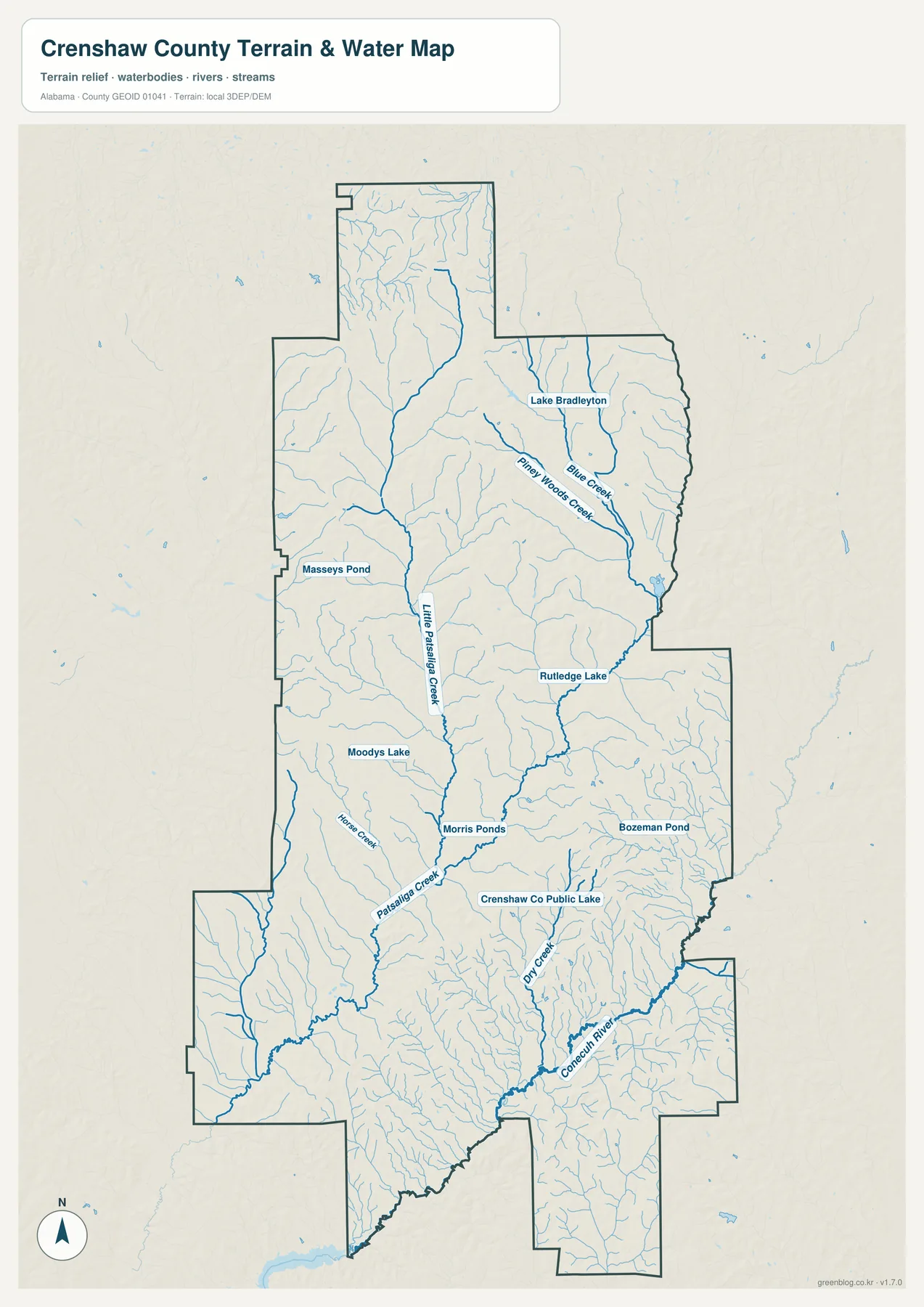
Patsaliga Creek is particularly useful for relating the central and southern parts of Crenshaw County. Existing USGS information lists a drainage area of 254 square miles at a station near Luverne and 442 square miles farther downstream near Brantley. Those figures show how tributaries accumulate as the system moves south. They also explain why a creek that may look modest at one crossing is an important organizing feature for a much larger part of the county.
This map is a geographic water reference, not a flood-hazard, property, legal-boundary, or navigation chart. It helps answer questions such as which named creeks are near a part of the county, where small lakes are distributed, and how tributaries connect to larger channels. Flood risk and regulated water boundaries require the appropriate official datasets for those specific purposes.
Elevation reveals ridges in the north and lower stream corridors
The elevation map uses terrain colors and shaded relief to make the county’s shape easier to understand. Its legend gives an actual elevation range of about 60 to 199 meters and a mean of 114 meters. Higher ground appears in brown and tan tones, while lower areas are shown in greener tones. The northern half has many closely spaced ridges and narrow valleys, and a particularly intricate pattern of relief is visible across the northwestern and north-central sections.
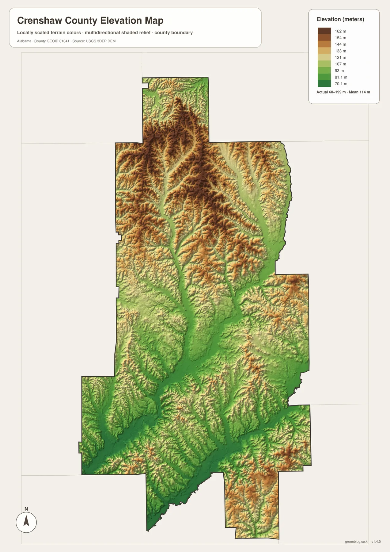
The central and southern portions are not completely flat, but the lower valleys become more continuous. Long green corridors line up with the drainage system seen on the water map, especially along the larger creek valleys. This makes the relationship between water and terrain easy to recognize: streams occupy the lower passages, while the surrounding land rises into repeated ridges and side slopes. Reading the two maps together is more informative than trying to infer terrain only from road placement.
The elevation layer is designed for county-scale comparison. It is appropriate for identifying broad high and low areas, ridge-and-valley texture, and the general setting of streams and settlements. It should not be treated as survey-grade elevation for engineering, construction, or parcel-level decisions. The shaded surface is intentionally generalized so that relief remains visible at the scale of the entire county.
How transportation and drainage help explain the county pattern
Crenshaw County was created on November 24, 1866, from parts of Butler, Coffee, Pike, and Lowndes counties. Rutledge became the first county seat the following year. Railroad development in the late nineteenth century accelerated Luverne’s growth, and voters moved the seat there in 1893. That history matters on a modern map because Luverne remains the most prominent central reference point, positioned where major routes serve the county in several directions.
Luverne also sits close to the Patsaliga Creek system. The road map and water map show different sides of the same place: highways make the town accessible from north, south, and east, while streams and low valleys shape the countryside around it. Farther south, Brantley has its own town center and lies within the same broader drainage system. The distance between the two places is filled by smaller roads, tributaries, farms, forest, and dispersed rural communities rather than continuous urban development.
Rail history remains useful context even though modern travel is dominated by highways. Luverne grew as rail service encouraged trade and timber shipment, and Petrey was associated with an Atlantic Coast Line branch serving small communities. Those older transportation patterns help explain why some settlement names occur where they do, while today’s U.S. and state highways provide the clearest structure for reading the county on a current map.
Which Crenshaw County map should you use?
Choose the general county map when you need the boundary, neighboring counties, road numbers, and the main town names in one view. Use the city map when the question is specifically about where Luverne, Brantley, Dozier, Rutledge, Glenwood, and Petrey sit relative to one another. The water map is the better choice for Patsaliga Creek, the Conecuh River, tributaries, ponds, and lakes, while the elevation map is the clearest way to compare ridges, valleys, and broad differences in height.
- General county map: boundary, neighboring counties, U.S. 331, U.S. 29, state routes, and major places
- City map: the relative distribution of Luverne, Brantley, Dozier, Rutledge, Glenwood, and Petrey
- Water map: Patsaliga Creek, Little Patsaliga Creek, Conecuh River, tributaries, lakes, and ponds
- Elevation map: county-scale high and low areas, ridges, and lower drainage corridors
For a classroom handout or a general county reference, start with the county map and add one specialized view only when needed. For a stream or terrain question, the reverse order may be better: begin with the water or elevation map and then use the county map to attach road and town names to what you found. This avoids forcing every piece of information into one crowded map and makes the four-file set useful for several different tasks.
Frequently Asked Questions
Why are Luverne and Rutledge both useful reference points?
Rutledge became Crenshaw County’s first seat in 1867, but the seat moved to Luverne in 1893 after Luverne grew during the railroad era. Their locations let you compare the county’s earlier administrative center with the town that later became the main central reference on the road network. On the current maps, Luverne also sits close to the U.S. 331 and U.S. 29 route pattern.
Is the water map a flood-risk map?
No. It is intended to show the location and connection of named streams, tributaries, lakes, and ponds. It does not determine flood zones, property rights, navigable waters, or regulatory boundaries. Use the relevant official flood or legal datasets for those decisions.
How precise is the elevation map?
It is a county-scale terrain reference. The map legend reports an actual range of about 60 to 199 meters and a mean of 114 meters, which is useful for comparing broad high and low areas. It is not a substitute for survey-grade elevation measurements used in engineering or parcel-level work.
Map File Information
High-resolution Crenshaw County map files
- Printable Size: A3 high resolution, 2572×3638 px each
Related Maps
Sources and reference data
The geographic background in this article can be checked against the following official and local sources. The map-specific descriptions are based on the four supplied Crenshaw County map previews and the asset information packaged with this rewrite task.
- U.S. Census Bureau QuickFacts
- ALDOT Highway Functional Classification Maps
- USGS Patsaliga Creek flow and drainage data
- USGS 3D Elevation Program
- Atlas Alabama: Luverne
- Town of Brantley official website
- Alabama Population Density Map: Urban Clusters, County Totals and a Decade of Change
- Crenshaw County Alabama Land Cover Map: Forest Majority, Wetland Ribbons & 4 JPGs
Green Map creates custom-edited map images using open geographic data sources such as geoBoundaries, Natural Earth, OpenStreetMap, and government open data. These maps are edited visual materials, not raw data files, and are provided for education, documents, presentations, and graphic reference.