Kershaw County Map users can read this part of South Carolina in two very different ways. Camden is the main road and administrative center, with I-20 and several U.S. and state highways meeting nearby, while the county’s western and eastern edges are shaped by major water systems: Lake Wateree and the Wateree River to the west, and the Lynches River system to the east. The downloadable ZIP on this page contains A3 high-resolution JPG versions of the county, city-connection, and terrain-water maps shown below.
The county is long enough that a single outline does not explain how its communities relate to one another. Elgin sits near the southwestern side, Bethune is far to the northeast, and Camden lies between them with Lugoff immediately to its west. The road map makes that settlement pattern easy to see, while the water map reveals a second framework of rivers, creeks, ponds, and the large Lake Wateree shoreline. Looking at both is more useful than treating Kershaw County as a simple shape on a statewide map.
Table of Contents
Camden as the road center between Elgin and Bethune
Camden is the county seat and the most obvious transportation reference on the general map. I-20 crosses the southern part of the county, passing near the Camden-Lugoff-Elgin area before continuing toward Columbia to the west and the Pee Dee region to the east. U.S. 1 links Camden with Lugoff and Elgin, while U.S. 521 and U.S. 601 provide important north-south references. South Carolina 34, 97, 341, 903, 157 and other numbered routes help show how the smaller communities connect to the county center.
The map also makes the county’s irregular boundary easier to understand. The western side reaches toward Lake Wateree and Fairfield County; the north meets Lancaster and Chesterfield counties; Lee and Darlington lie to the east and southeast; Sumter and Richland are farther south and southwest. These surrounding labels matter because Kershaw County is not a neat rectangle. Its northern projection around Bethune and its broader western side can be difficult to recognize when the county is viewed without neighboring geography.
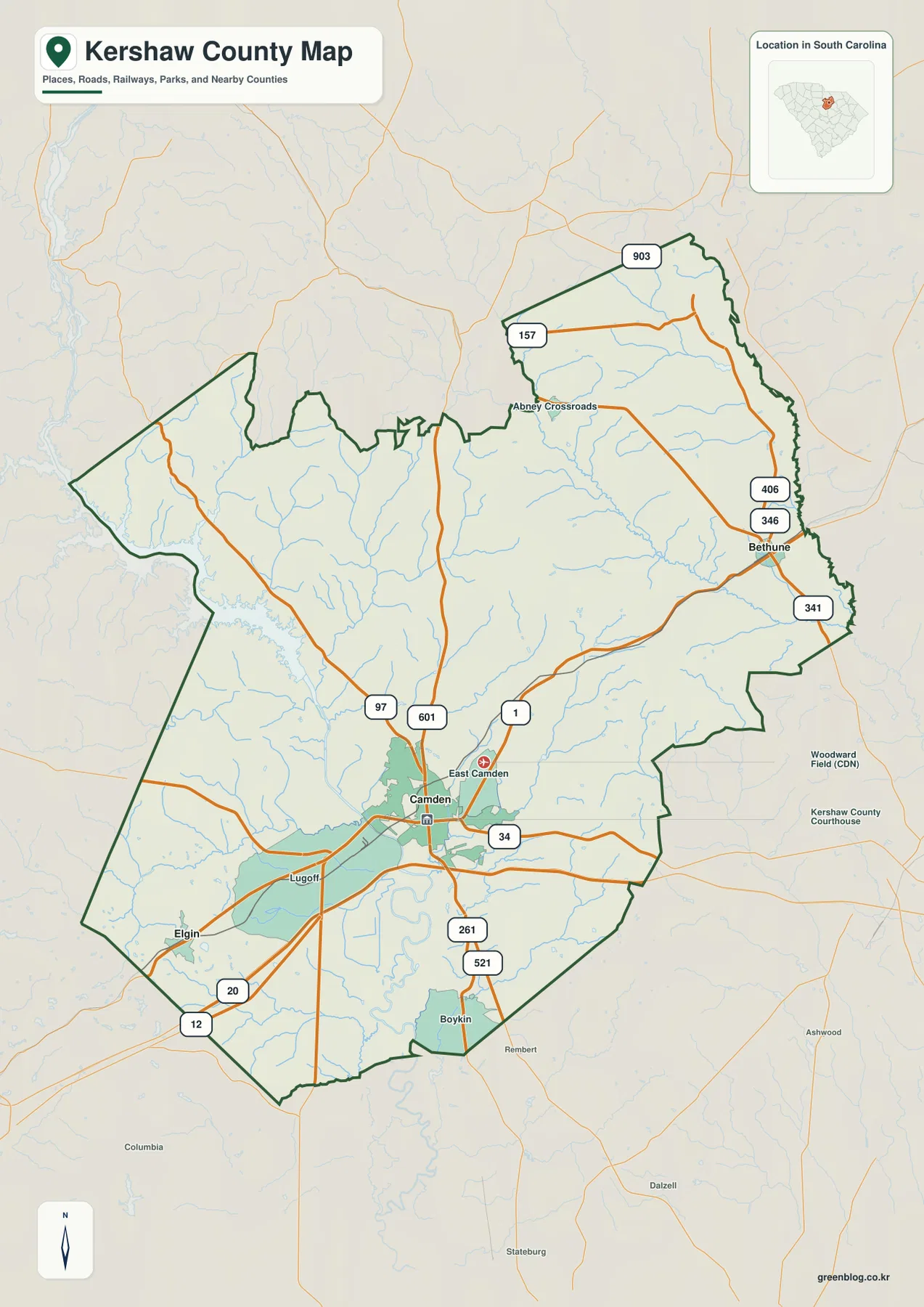
Several smaller references add useful local orientation without turning the image into a street map. Boykin appears south of Camden, Abney Crossroads is marked in the north, and the surrounding road network shows where the main corridors leave the county. The pale context outside the dark county line helps the reader follow roads beyond the boundary while keeping Kershaw County visually distinct. That makes this version the strongest choice when the question is about overall position, highway access, or where the major named communities sit inside the county.
A simpler city view for the county’s long southwest-to-northeast spread
The city-connection map strips away many labels and focuses on three locations: Camden, Elgin, and Bethune. Camden is the hub, Elgin lies to the southwest, and Bethune lies to the northeast. This arrangement is useful because the two outer towns sit on opposite sides of the county, making the county’s length immediately apparent even to a reader who does not know the local road system.
The distance labels on this map are straight-line distances from Camden, not driving distances. Elgin is shown at about 12 miles from the hub and Bethune at about 18 miles. Actual road trips are longer and vary by route, so these numbers should not replace navigation directions. Their purpose is to compare spacing. Elgin is closely tied to the I-20 and U.S. 1 side of the county, whereas Bethune is reached through the northeastern road network near South Carolina 341 and other state routes.
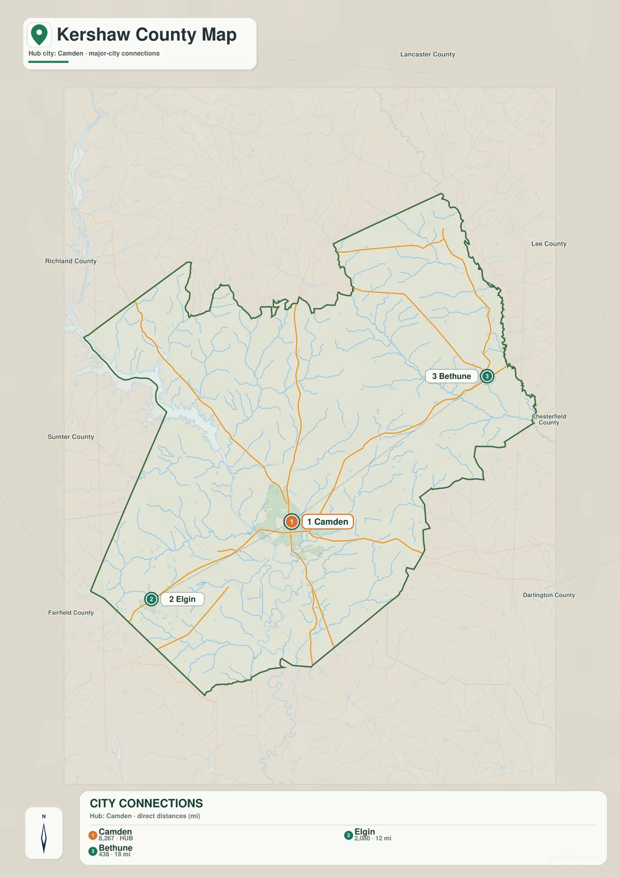
Lugoff is visible on the general map but is intentionally not one of the three numbered city markers on this simplified version. That difference is useful rather than a mistake. The general map is better for road and place context; the city map is designed to answer a narrower question about how far the main labeled municipalities spread across the county. Switching between the two prevents a dense road network from hiding the larger settlement pattern.
Lake Wateree, the Wateree River, and the Lynches River system
Water is one of the defining features of Kershaw County, especially on the western side. Lake Wateree occupies a broad reservoir area along the county’s western edge, and the Wateree River continues southward through the county. Kershaw County’s own website highlights the Wateree River, and county planning pages treat Lake Wateree as a major local resource. On the terrain-water map, the broad lake and river system gives the western boundary a very different appearance from the drier road-focused center of the county.
The eastern half has its own strong water network. The Lynches River runs along the northeastern and eastern side, while the Little Lynches River crosses toward it from the interior. Grannies Quarter Creek, Sanders Creek, Twenty Five Mile Creek, Big Pine Tree Creek, and Swift Creek are among the smaller named channels shown on the map. These streams are not decorative details: together they explain why the county’s interior is divided into many small drainage corridors rather than one broad river valley.
Several smaller water bodies are labeled as well, including Colonial Lake, Kendall Lake, Heritage Mill Pond, Adams Mill Pond, Boykin Mill Pond, and White Pond. Their distribution is especially noticeable south and southwest of the county center. The names help a reader distinguish the large regional rivers from local ponds and creek systems, which is useful when a project needs more than a simple county outline but does not require a full hydrographic database.
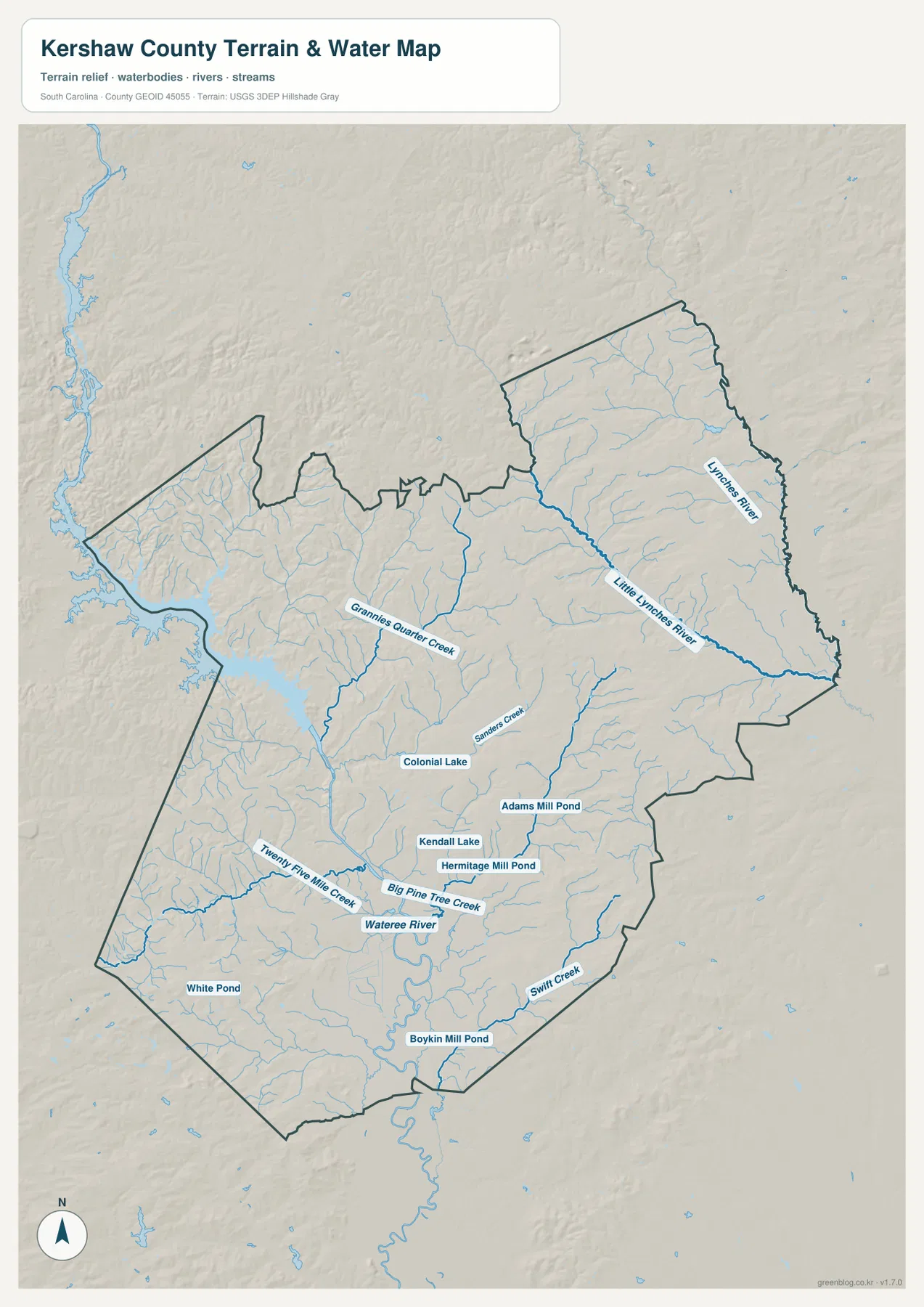
The shaded relief adds a gentle sense of terrain behind the waterways. It helps separate low stream corridors from the higher ground between them, but it is not a survey-grade elevation product and it does not show flood zones. Anyone making engineering, parcel, or flood-risk decisions should use the appropriate county, FEMA, or USGS datasets instead. For this page, the relief is there to explain why the rivers and tributaries occupy particular parts of the landscape and to make the water network easier to follow.
Choosing the map that answers the question fastest
The three supplied maps are most useful when they are treated as separate views rather than as duplicate versions of the same graphic. The general county map is the best starting point for boundaries, roads, Camden, Lugoff, Elgin, Bethune, and surrounding counties. The city map is cleaner when the only task is comparing Camden with Elgin and Bethune. The terrain-water map should be used when Lake Wateree, the Wateree River, the Lynches River system, creeks, ponds, or relief are the main subject.
A classroom presentation about transportation might begin with I-20 and the Camden road cluster, then switch to the city map to show the county’s length. A natural-resources summary could start with the western lake and river system and then move east to the Lynches and Little Lynches rivers. For a general county profile, using the general map first and the water map second gives a balanced view of human connections and physical geography without crowding everything onto a single image.
What these maps do not replace
These are county reference maps, not legal surveys, parcel maps, turn-by-turn navigation products, or flood-hazard maps. Road symbols are generalized, city markers are meant for orientation, and the water map is designed to show named water features and terrain context rather than regulatory boundaries. If a project depends on exact property lines, current road engineering, flood elevations, or permit requirements, the relevant official county or federal source should be consulted directly.
For ordinary map use, that simplification is an advantage. The county boundary remains clear, Camden can be found quickly, and the main road and water relationships are visible without a large amount of GIS labeling. A reader can move from the general map to the city or water map depending on the question instead of trying to decode every feature at once. The downloadable JPGs preserve this same structure at a size better suited to print.
Frequently Asked Questions
Are the Camden-to-Elgin and Camden-to-Bethune distances road mileage?
No. The city-connection map uses straight-line distances from Camden. It shows Elgin at roughly 12 miles and Bethune at roughly 18 miles from the hub, which is useful for comparing their relative spacing. Driving distance will be different because vehicles must follow the actual road network.
Which map is best for Lake Wateree and the Wateree River?
The terrain-water map is the clearest choice because it emphasizes Lake Wateree, the Wateree River, the Lynches and Little Lynches rivers, and numerous smaller creeks and ponds. The general map is better when you need to see those water features in relation to Camden and the major roads. Neither version should be used as a flood-zone or navigation map.
What is included in the downloadable ZIP?
The archive contains three A3 high-resolution JPG files matching the map types shown in the article: a general county map, a Camden-centered city-connection map, and a terrain-water map. The WebP images in the article are lighter previews, while the JPG files are the versions intended for larger display and printing.
Map File Information
The ZIP contains A3 high-resolution JPG versions of the Kershaw County general map, city-connection map, and terrain-water map. These larger files are intended for printing or insertion into documents when the smaller WebP previews are not sufficient.
- Included Files: 3 high-resolution A3 JPG map files shown in this article
- File Type: JPG files in a ZIP archive
- Intended Use: Printing, education, presentations, and map-based projects
Related Maps
Sources and references
- Kershaw County, South Carolina — county information and local Wateree River context
- Kershaw County Lake Wateree information — county planning and lake context
- U.S. Census Bureau TIGER/Line Shapefiles — county, place, and road geography
- USGS The National Map — national hydrography, elevation, and base geographic data
Green Map creates custom-edited map images using open geographic data sources such as geoBoundaries, Natural Earth, OpenStreetMap, and government open data. These maps are edited visual materials, not raw data files, and are provided for education, documents, presentations, and graphic reference.