Smith County Mississippi Map files are available to download directly from this page. The supplied views cover the county boundary and roads, ranked city distribution, water features, and elevation, with Raleigh, Taylorsville, Polkville, Mize, and Sylvarena providing the clearest place references. Strong River, Leaf River, the Okatoma Creek system, and numerous smaller streams occupy lower valleys between long wooded ridges. The download ZIP contains all four supplied maps as high-resolution A3 JPG files for printing, editing, classroom use, or location-reference graphics.
Smith County is not organized around one large city or an interstate highway. Raleigh is the county seat, Taylorsville is the largest place shown on the city map, Polkville is far to the northwest, and Mize and Sylvarena occupy the southern half. Between them, the map is filled with rural roads, narrow valleys, and repeated ridge lines. The water and elevation views therefore add essential context: they show why roads and settlements are separated by long stretches of rolling, forested terrain.
Table of Contents
Quick Facts
The Census figures supplied in the package list 14,209 residents in the 2020 census and a July 2025 estimate of 13,991. These values use different reference dates and methods, so they are best treated as separate benchmarks rather than identical measurements taken several years apart. Smith County’s FIPS code is 28129, and Raleigh is the county seat.
The supplied 2025 Gazetteer values list 636.268 square miles of land and 1.004 square miles of water. Using the 2020 population and that land area gives roughly 22.3 residents per square mile, but this is only a countywide average. Settlement is concentrated differently around Raleigh, Taylorsville, smaller towns, and the road corridors, while large wooded and stream-cut areas are much more sparsely populated.
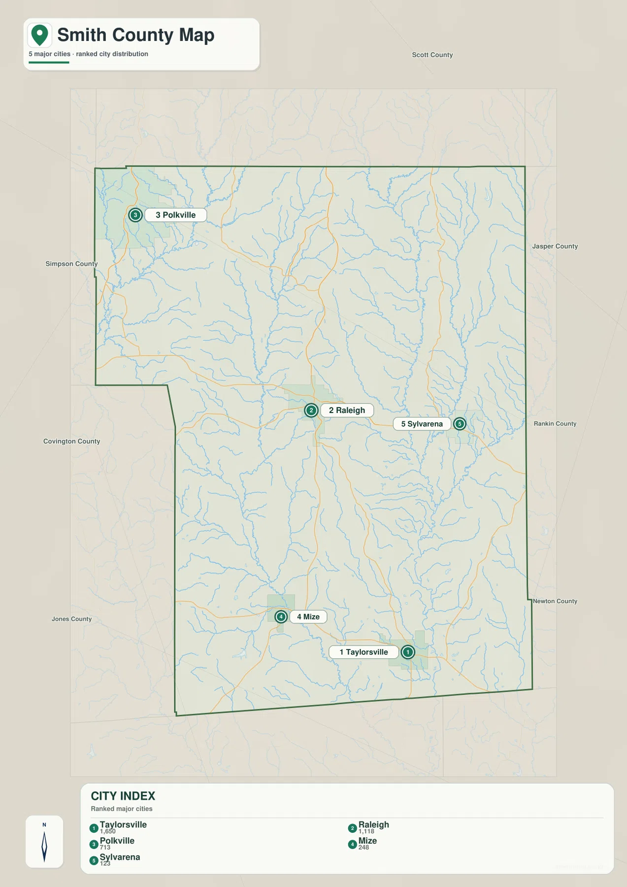
The city map ranks Taylorsville at 1,650, Raleigh at 1,118, Polkville at 713, Mize at 248, and Sylvarena at 123. Those figures are useful for comparing the selected communities rather than for describing the whole county. They also highlight an important distinction: Taylorsville is the largest place in this city index, while Raleigh remains the county’s administrative center.
Reading the Smith County Mississippi map
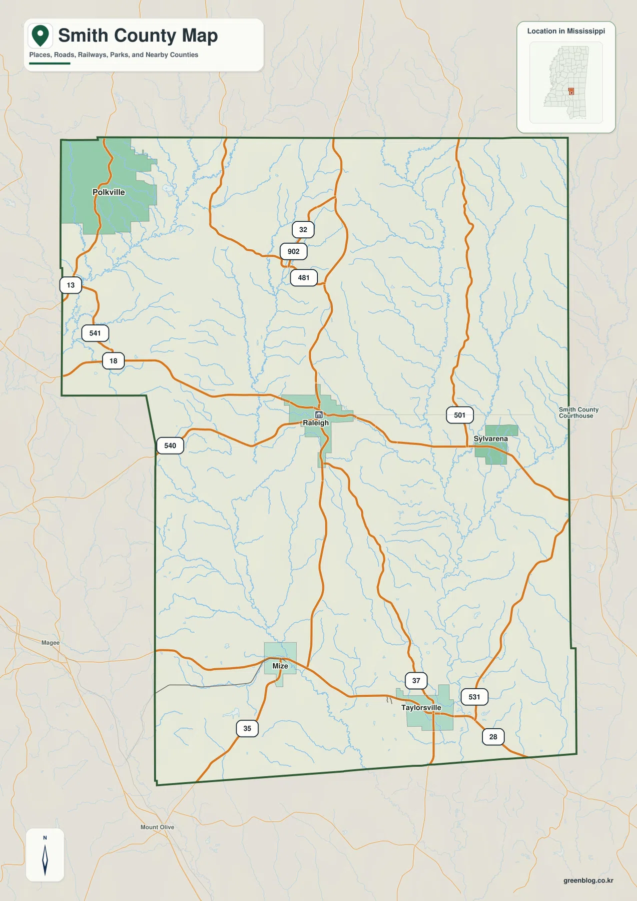
Raleigh is the most practical place to begin on the general county map. MS 18 runs through the Raleigh area and connects west toward Simpson County and east toward Sylvarena and Jasper County. A major north-south state-route corridor also passes through Raleigh and continues toward the Taylorsville side. Polkville in the northwest is reached by the MS 13 and MS 541 area, while Mize in the southwest is associated with MS 35. Taylorsville has several road references around it, including MS 37, MS 28, and MS 531.
North of Raleigh, the map labels MS 481, MS 902, and MS 32. MS 501 is visible on the Sylvarena side, and MS 540 appears in the western and southwestern part of the county. The number of route labels can look complicated, but the settlement pattern is simple enough once Raleigh is fixed in the center: Polkville is northwest, Sylvarena is east, Mize is southwest, and Taylorsville is south-southeast. With no interstate crossing the county, these state and local roads carry much more of the regional orientation.
The ranked city map makes the dispersed settlement pattern especially clear. Polkville sits near the northwestern corner, Raleigh occupies the middle, Sylvarena lies to the east, and Mize and Taylorsville are in the southern half. Scott County is to the north, Jasper County is to the east, and the Simpson, Covington, Jones, and Newton directions frame the remaining sides. The result is a county of small communities separated by broad rural terrain rather than a single continuous urban corridor.
Boundary, Water, and Terrain
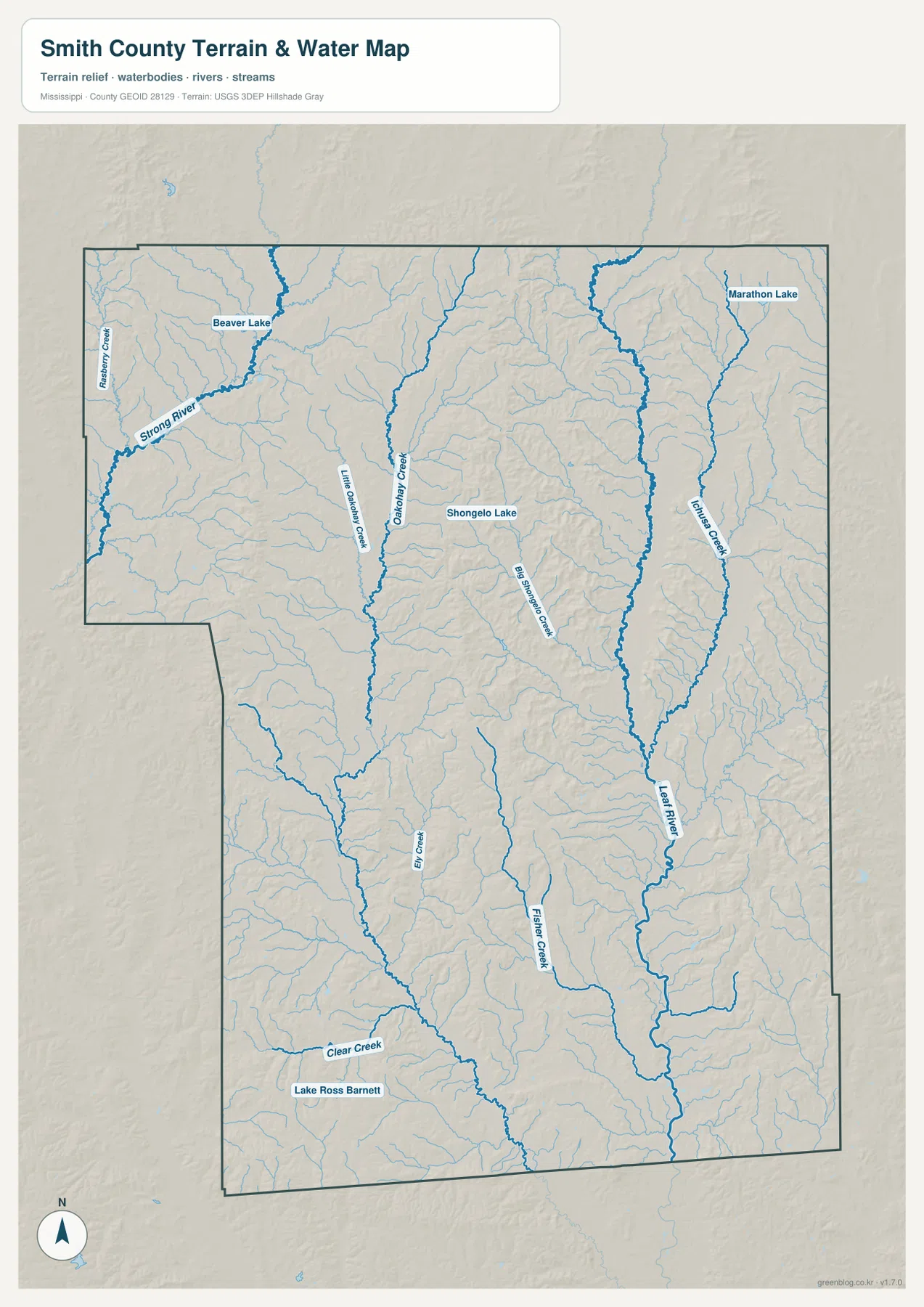
Strong River is one of the easiest large waterways to identify on the northwestern side of the terrain-and-water map. Beaver Creek joins the same broad drainage area, and Beaver Lake is labeled nearby. In the north-central interior, Little Okatoma Creek and Okatoma Creek run through long valleys. Big Sprinkle Creek forms another major north-south drainage line farther east. Between those named channels, a dense network of smaller tributaries cuts the hills into narrow ridge-and-valley bands.
Turner Creek is prominent on the eastern side, and Leaf River becomes a strong named reference in the southeast. Big Creek and Fisher Creek occupy the central-southern portion, while Clear Creek is labeled farther southwest. Shongelo Lake, Marathon Lake, and Lake Ross Barnett provide additional waterbody references. Marathon Lake is treated in the supplied existing material as a small recreation lake, not as a county-scale reservoir that dominates the hydrology.
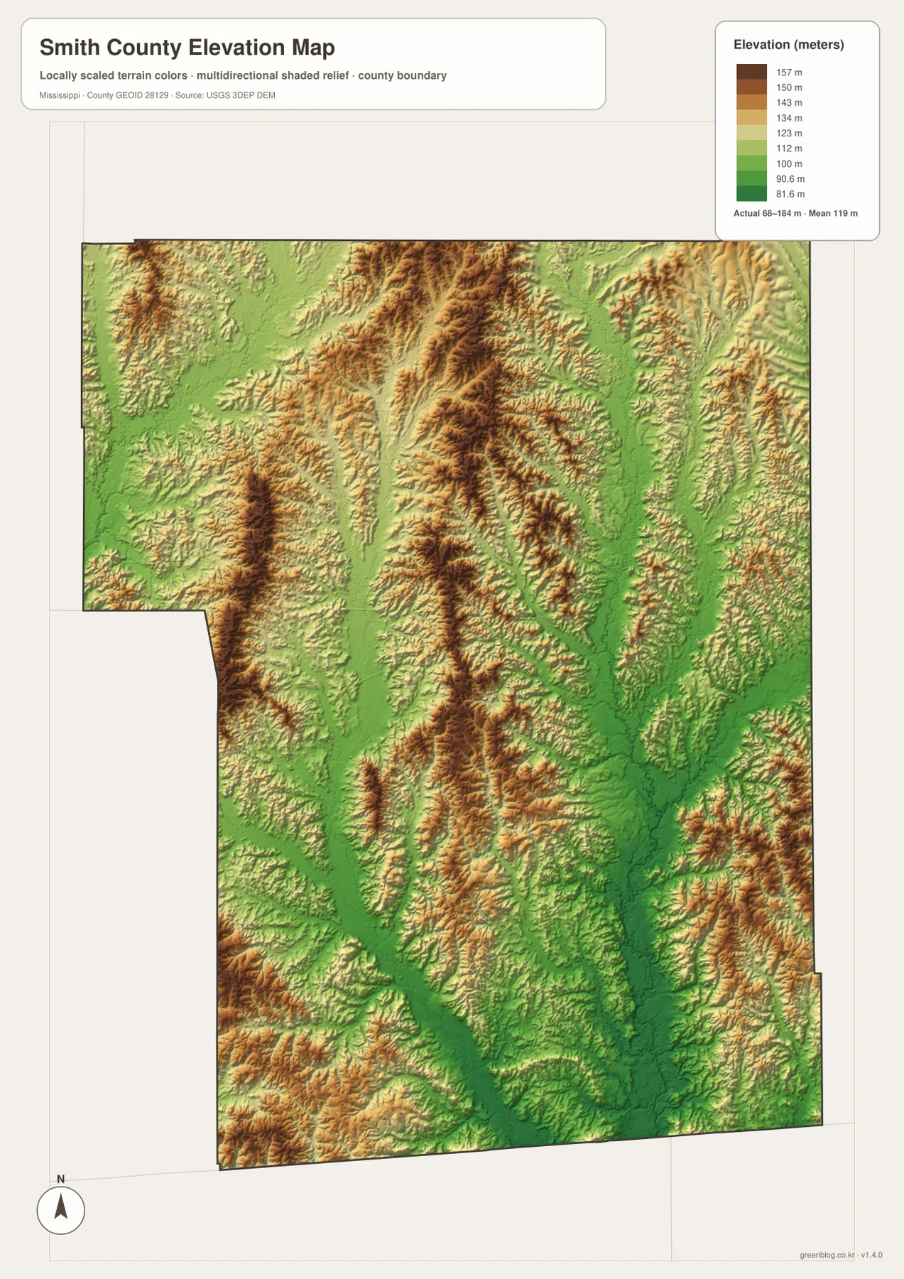
The elevation map prints an actual range of about 68 to 184 meters and a mean of about 119 meters. Green low ground follows the major stream corridors, while tan and brown ridges form long, repeated bands through the north, center, and east. The eastern side is especially dissected by valleys around Turner Creek and the Leaf River drainage. The south contains a mix of broader low corridors and shorter high ridges rather than one simple slope.
Comparing the water and elevation maps makes the landscape much easier to understand. Strong River, the Okatoma Creek system, and Leaf River occupy lower corridors, while the land between them rises into narrow wooded ridges. The elevation surface is generalized for county-scale comparison and should not be used as survey data for a building site, road grade, drainage design, or construction decision. Its role here is to explain the broad relationship between streams and the surrounding hills.
Settlement and Regional Context
Raleigh is the county seat and is the clearest administrative reference on the map. Its central position makes it easy to explain Polkville to the northwest, Sylvarena to the east, Mize to the southwest, and Taylorsville to the south. Taylorsville plays a different role: it is the largest place on the ranked city map and has a denser group of road labels around the southern city area.
The supplied existing material uses Bienville National Forest as an important landscape reference for Smith County’s wooded hill country. The elevation map supports that regional description by showing long ridges separated by stream valleys. This page does not map legal forest ownership or management boundaries, so anyone needing precise national-forest limits should use a dedicated U.S. Forest Service source rather than infer them from the county map.
Marathon Lake is another familiar local reference, but the water map puts it in perspective. It is a small recreation lake within a much larger network of rivers and creeks. For understanding Smith County as a whole, Strong River, the Okatoma system, Turner Creek, Leaf River, and the many smaller tributaries tell more of the physical story than any single lake.
Practical Map Uses
Use the general county map when the boundary, major state routes, Raleigh, and Taylorsville need to appear together. The city map is better for comparing the distribution and relative scale of Taylorsville, Raleigh, Polkville, Mize, and Sylvarena. Choose the water map when Strong River, Leaf River, the Okatoma Creek system, or the lakes are the main subject. The elevation map is the clearest option for showing the long ridge systems and lower stream valleys.
For a classroom or presentation, pairing the general map with the elevation map makes it easier to connect roads and settlements with the terrain beneath them. For a natural-landscape explanation, the water and elevation maps work especially well together: one identifies the drainage network, while the other reveals the lower corridors followed by those streams and the ridges between them.
The WebP images on the page are optimized as previews. The high-resolution JPG originals in the archive are better for printing and editing. These maps are general geographic references, not parcel surveys, engineering drawings, flood-risk maps, or live navigation products, so specialized current sources are still required for property, construction, flood, or real-time travel decisions.
Frequently Asked Questions
Is Marathon Lake a major reservoir?
No. It is a small recreation lake within the national forest and works as a local reference rather than a countywide water feature.
What does Bienville National Forest add between Raleigh, Taylorsville, and the boundary with Scott?
Raleigh and Taylorsville locate communities, whereas Bienville National Forest explains terrain or drainage before the map reaches the Scott boundary.
Map File Information
The ZIP contains the Smith County county, city, water, and elevation maps as high-resolution A3 JPG files. These originals are larger than the WebP page previews and are suitable for printing, editing, classroom materials, or location-reference graphics.
- File Type: four high-resolution JPG files in one ZIP
Related Maps
Sources
- U.S. Census Bureau QuickFacts for Smith County — population reference
- U.S. Census Bureau Gazetteer Files — land and water area reference
- Mississippi Department of Transportation Official Highway Map — major route reference
- U.S. Forest Service Marathon Lake — recreation lake and forest-area reference
- USGS National Hydrography — river, creek, and waterbody reference
- USGS 3D Elevation Program — elevation and terrain reference
Green Map creates custom-edited map images using open geographic data sources such as geoBoundaries, Natural Earth, OpenStreetMap, and government open data. These maps are edited visual materials, not raw data files, and are provided for education, documents, presentations, and graphic reference.