Lyon County sits in east-central Kansas where the road network around Emporia meets a landscape shaped by the Cottonwood and Neosho rivers and the rolling Flint Hills. Emporia, the county seat, occupies the central-southern part of the county, while Americus, Allen, Reading, Olpe, Hartford, and Neosho Rapids are spread in different directions across a much larger rural area. The result is a county map with one strong urban reference point and many smaller communities separated by streams, grassland, and local roads. High-resolution map files are available for download in the section below.
This page provides several ways to understand that geography without forcing every detail onto a single image. You can compare settlements and highways, follow named rivers and creeks, and see how elevation changes from the higher western hills into lower river valleys. The high-resolution JPG originals can also be downloaded in one ZIP for printing, classroom work, offline reference, or presentation use. Each map emphasizes a different part of Lyon County, so the best choice depends on whether you need roads, communities, water, or terrain.
Table of Contents
Emporia anchors the road network around I-35 and US 50
Emporia is the clearest landmark on the general county map. US 50 crosses the area from west to east through the city, while I-35 approaches from the southwest, passes the Emporia area, and continues northeast. Together they make the county seat an easy starting point for reading the rest of the road pattern. K-99 extends north from the Emporia area, K-130 appears along the eastern side near Hartford and Neosho Rapids, and K-57 and K-58 provide additional references around the southern part of the county near Olpe.
The smaller places are widely spaced rather than clustered into one continuous built-up area. Americus lies northwest of Emporia, Allen is farther north near US 56, Reading is to the east, and Olpe sits well to the south. Hartford and Neosho Rapids occupy the southeastern side of the county, while Bushong appears as a much smaller place in the northwestern portion. Seeing all of these names on one map makes it easier to understand how a single county can contain a strong regional center and still remain predominantly rural outside that center.
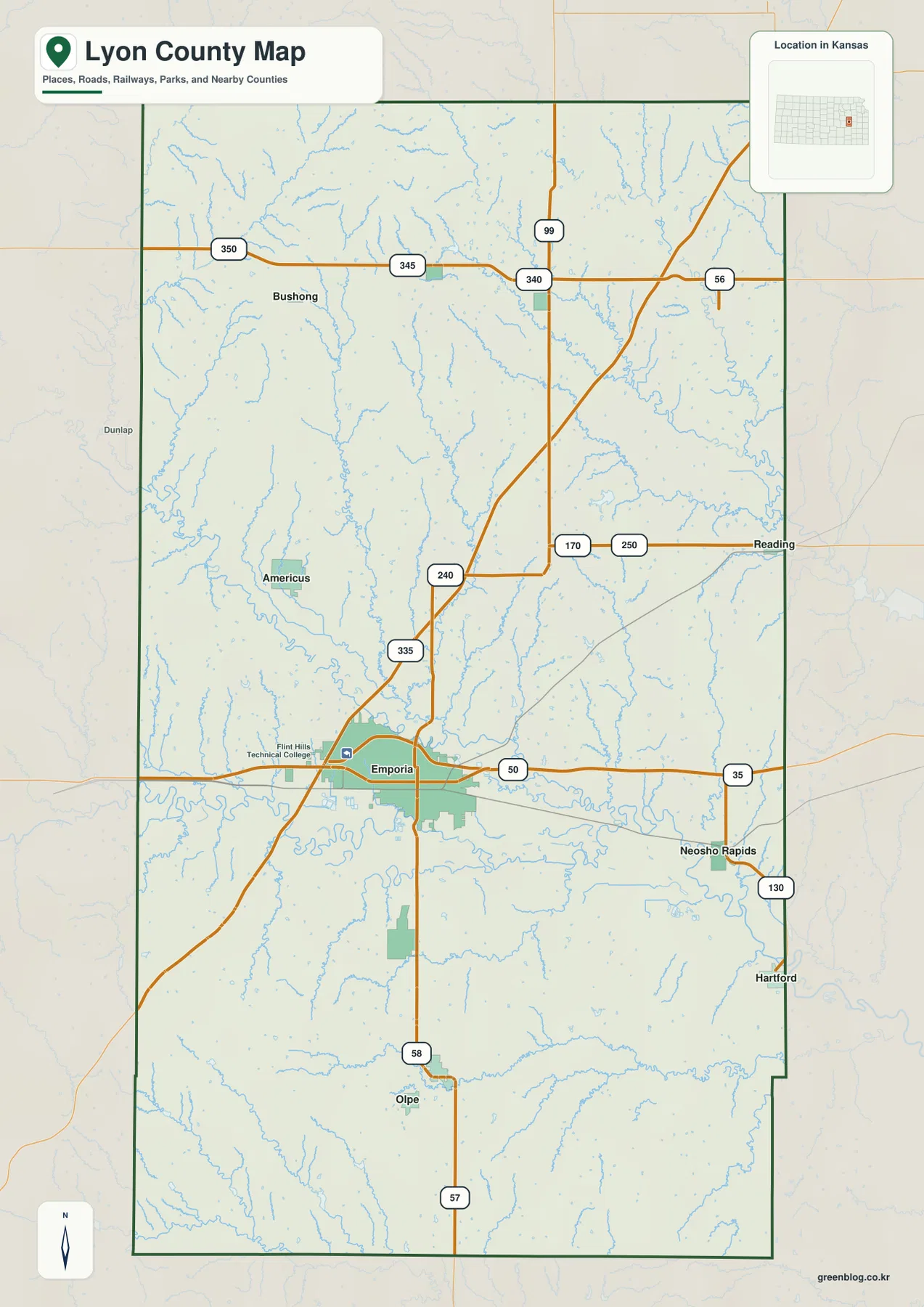
Neighboring county labels add useful regional context. Wabaunsee County is to the north, Osage and Coffey counties lie along the eastern side, and Morris and Chase counties are to the west and northwest. Greenwood County borders the southwestern side. These labels are not a substitute for turn-by-turn navigation, but they help when comparing adjacent county maps or when locating Lyon County within the broader Flint Hills and east-central Kansas region.
The city index separates Emporia from a ring of smaller communities
The city map removes much of the road detail and ranks six major communities so their relative positions stand out. Emporia is the dominant center. Americus appears to the northwest, Olpe to the south, Hartford to the southeast, Allen to the north, and Neosho Rapids to the east-southeast. This simplified arrangement is useful when the question is not which highway to take, but where one town sits in relation to another across the county.
The map also shows why a trip between two Lyon County communities can involve more distance than the county name alone might suggest. Emporia and Americus are separated by rural land and stream valleys, while Olpe is well south of the county seat and Hartford is close to the eastern edge. The city map is best treated as an orientation graphic rather than a mileage chart. For an actual drive, use the general map for road context and a current navigation source for closures, travel times, and route conditions.
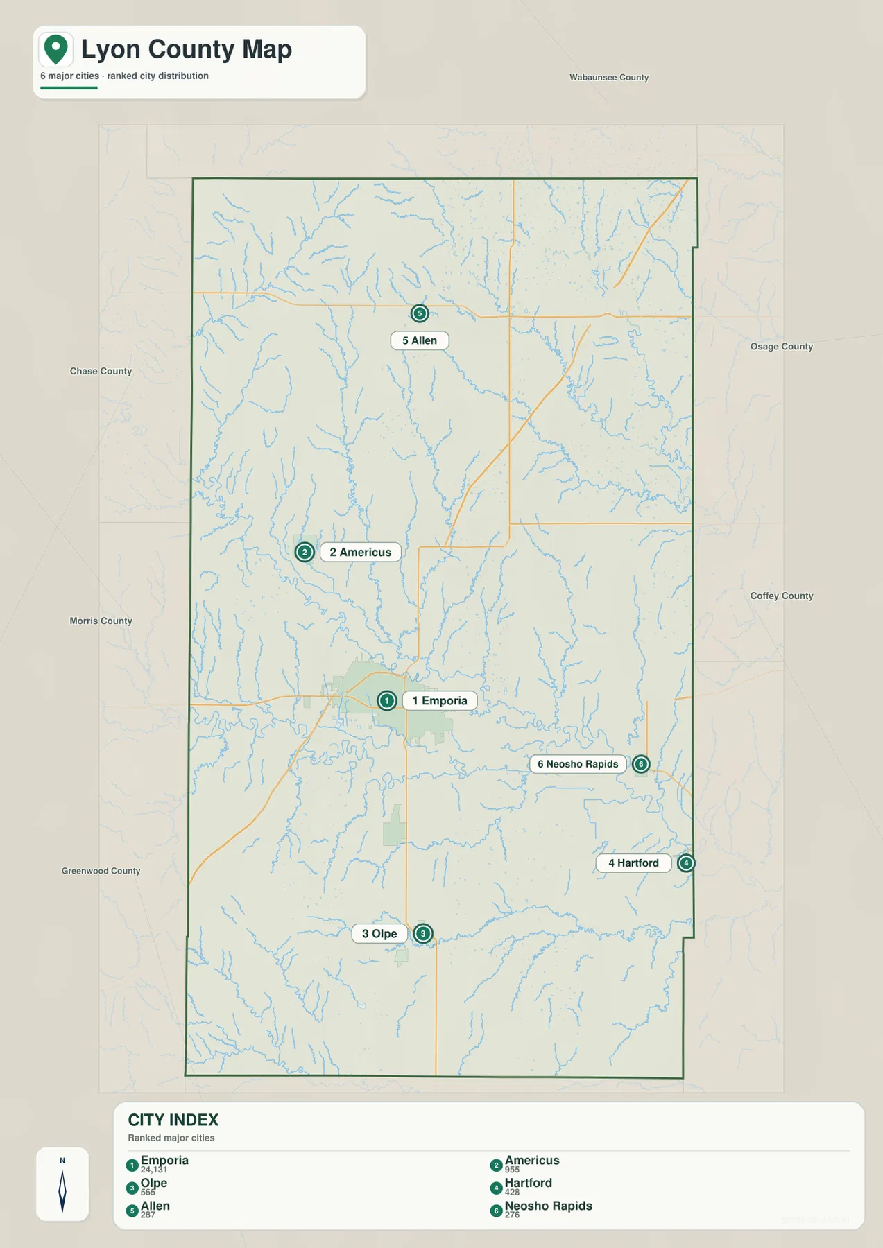
Historical records give this pattern additional context. The Kansas Historical Society identifies Emporia as the county seat and notes that Americus won an early county-seat election before Emporia became the seat in 1860. The modern map does not portray that political history directly, but the two communities remain easy to compare geographically: Americus is northwest of Emporia, while Emporia occupies a more central position near major transportation routes and large river corridors.
Cottonwood and Neosho river valleys organize the county’s drainage
The terrain-and-water map changes the visual emphasis completely. The Cottonwood River enters from the west and follows a broad, winding route across the central-southern portion of Lyon County. The Neosho River forms another major corridor toward the east and southeast. Emporia is historically described as lying between these two rivers, and the water map makes that relationship much easier to understand than a road-only view. The large channels are surrounded by a dense network of smaller creeks descending from the surrounding hills.
Allen Creek is a prominent north-to-south tributary in the western-central part of the county. Elm Creek is clearly labeled in the northeast, while Hill Creek, Moon Creek, and Duck Creek help define smaller valleys in the central and eastern areas. Dry Creek appears south of the Cottonwood corridor, and Eagle Creek runs across the southern part of the county near Olpe. These names make the water map useful for local orientation because they show how many smaller drainage lines connect to the two major river systems.
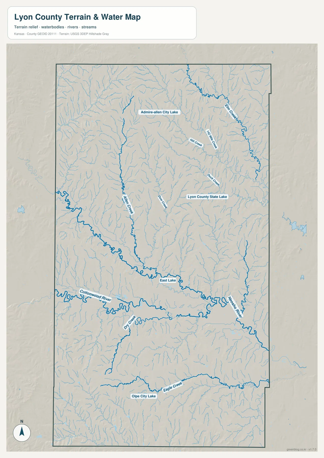
Several lakes also appear by name. Admire-Allen City Lake is in the northern portion of the county, Lyon County State Lake lies farther east of the center, East Lake is labeled near the main river corridor, and Olpe City Lake is in the south. The Kansas Department of Wildlife and Parks describes Lyon State Fishing Lake as being about 13 miles north of Emporia on K-99 and then east on a county road. The agency also places it on the eastern edge of the Flint Hills, surrounded by native tallgrass prairie and public wildlife land.
This map should be read as a geographic reference, not as a live statement about flow conditions, flood risk, water quality, fishing rules, or public access. A blue line can represent a mapped stream even when seasonal conditions differ on the ground. Anyone planning fishing, boating, hiking, or property-related work should check the appropriate agency for current regulations and site access. For general county orientation, however, the map clearly explains why rivers and creek valleys are such a strong part of Lyon County’s landscape.
Elevation ranges from about 318 to 466 meters across hills and valleys
The elevation map reports an actual county range of roughly 318 to 466 meters, with a mean near 368 meters. Higher terrain is concentrated in the west, northwest, and parts of the southwest, where warm brown and tan colors cover broad ridges and rolling uplands. Lower green areas form a wider belt through the central and eastern portions of the county. The most obvious low corridors correspond closely to the Cottonwood and Neosho river valleys and to the many tributaries that descend into them.
This relief is one reason a simple description of Lyon County as “flat Kansas” misses important local detail. The Flint Hills are expressed as rolling, dissected uplands rather than dramatic mountains, but the shaded relief reveals many narrow ridges and branching valleys. In the northwest, the ground is noticeably higher and more strongly cut by small drainage lines. Moving toward the central river corridors, the surface becomes lower and broader, then rises again in places between tributaries.
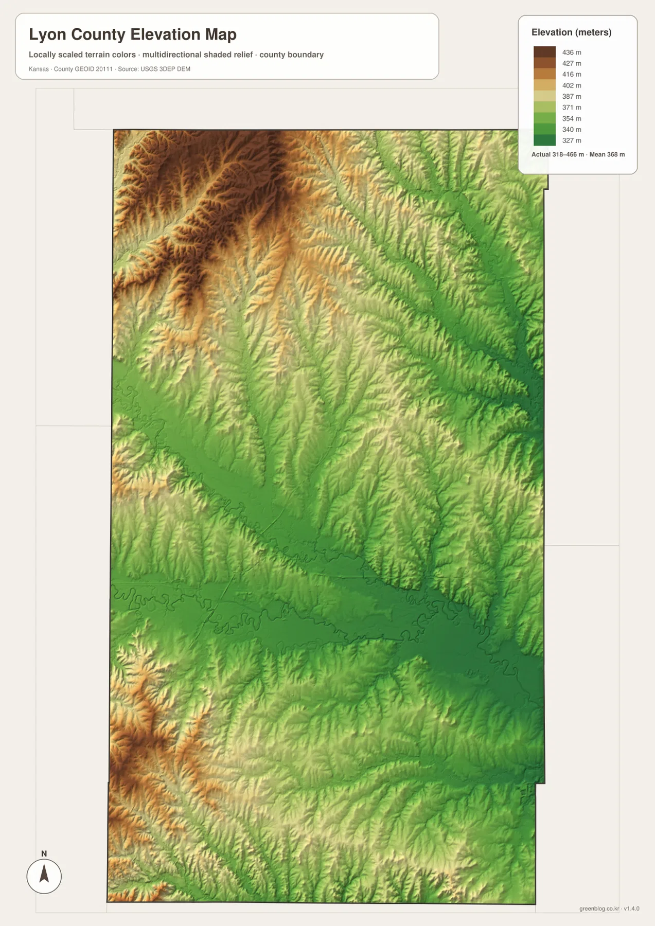
The elevation colors are useful for county-scale comparison but should not be treated as survey measurements for a parcel or construction site. Engineering, drainage design, and boundary work require more detailed data and, when appropriate, professional field surveys. For education, travel planning, or regional explanation, the map is well suited to showing why streams follow certain low corridors and why roads and settlements sometimes occupy flatter ground between or beside the hills.
Flint Hills grassland and Santa Fe Trail history add context beyond the roads
The terrain visible on the maps connects directly to Lyon County’s broader regional identity. The Kansas Department of Wildlife and Parks describes the Lyon State Fishing Lake area as part of the eastern edge of the Flint Hills, with native tallgrass prairie dominating much of the drainage basin. That description fits the elevation map, where rolling higher ground is divided by many small wooded or stream-cut draws. The relief is subtle compared with mountainous country, but it is persistent enough to shape drainage, roads, and views across the county.
The Kansas Historical Society also notes that the Santa Fe Trail passed through the northern part of Lyon County. The current maps are not historical trail reconstructions, so they should not be used to trace the exact nineteenth-century route. They do, however, provide a useful geographic frame for reading trail history because northern communities, road corridors, streams, and uplands can be located first. Historical interpretation becomes easier when the modern county’s distances and terrain are already familiar.
Emporia adds another well-known historical connection through author and newspaper editor William Allen White, whose home is preserved as a National Historic Landmark. That cultural history is separate from the map layers, but it helps explain why Emporia has an identity that extends beyond its role as the county seat. Readers interested in visiting historic sites should use official museum or local-government information for hours, access, and current conditions rather than relying on a county-scale map alone.
Choosing the best file for roads, towns, water, terrain, or print
Use the general county map when you need Emporia, neighboring communities, major highways, county boundaries, and nearby counties in one view. Choose the city index when your main question is how Americus, Olpe, Hartford, Allen, and Neosho Rapids are positioned around Emporia. The terrain-and-water map is the strongest file for following the Cottonwood and Neosho rivers, locating named creeks, or comparing lakes. The elevation map is best for explaining the higher western hills and the lower central and eastern river corridors.
The files are often most useful in sequence. Start with the city map to locate Olpe, then move to the general map for the surrounding roads and finally to the water map to see Eagle Creek and nearby drainage. For the Cottonwood River, identify the river on the water map and switch to the elevation image to see the lower valley that contains it. This approach keeps each map readable while still allowing roads, settlement, water, and relief to be connected.
For printing or a large presentation slide, use the original JPG files in the ZIP instead of enlarging the web previews. The higher-resolution versions preserve small route labels, creek names, lake labels, and subtle elevation shading more effectively. If you crop a map for a focused handout, keep the title and essential context whenever possible. The elevation legend should remain visible when discussing height, and water labels should remain visible when individual rivers or creeks are part of the explanation.
Frequently Asked Questions
Which map is best for comparing Emporia, Americus, and Olpe?
Start with the city map because it simplifies the county to the main communities and makes their relative positions easy to compare. Emporia is the central reference, Americus lies northwest, and Olpe lies to the south. If you also need the highways or local route context, use the general county map alongside it and rely on a current navigation service for actual driving directions.
Where can I see the Cottonwood and Neosho rivers most clearly?
The terrain-and-water map is the clearest option. It labels the Cottonwood and Neosho rivers and also shows Allen Creek, Elm Creek, Duck Creek, Eagle Creek, and other tributaries. Several lakes are labeled as well, making this file more useful than the road map when the goal is to understand drainage and water features.
Can the 318–466 meter elevation range be used for property surveying?
No. The elevation map is designed for county-scale terrain comparison. It shows broad differences between uplands and valleys but does not provide survey-grade elevation for individual parcels, structures, or engineering sites. Precise work requires appropriate detailed elevation data and, when necessary, a professional survey.
Map File Information
The archive contains the Lyon County, Kansas general county map, city map, terrain-and-water map, and elevation map as original high-resolution JPG files for printing and offline use.
- Included Files: Use only the versions confirmed in the article and supplied images
- File Type: Use the confirmed download contents
- Intended Use: Printing, education, presentations, and map-based projects
Related Maps
Sources and references
- Kansas Historical Society: Lyon County, Kansas — county history, Emporia as county seat, Santa Fe Trail, and regional background
- Kansas Department of Wildlife and Parks: Lyon State Fishing Lake — lake location, Flint Hills setting, and public wildlife area context
- U.S. Census Bureau TIGER/Line Shapefiles — county boundary and geographic reference data
- USGS National Hydrography — river and stream reference data
- USGS 3D Elevation Program — elevation and terrain reference data
Green Map creates custom-edited map images using open geographic data sources such as geoBoundaries, Natural Earth, OpenStreetMap, and government open data.
These maps are edited visual materials, not raw data files, and are provided for education, documents, presentations, and graphic reference.