If you need a Bryan County Georgia Map for a report, classroom handout, presentation, or general location reference, this page brings four complementary views together. The county map shows the boundary, Pembroke, Richmond Hill, and the main road pattern; the city map strips the picture down to the two major city markers; the water map follows inland creeks toward coastal rivers and sounds; and the elevation map shows how the higher inland northwest gives way to very low coastal ground. The on-page previews are WEBP images, while a downloadable ZIP contains four high-resolution A3 JPG files for larger use.
Bryan County is easier to understand when Pembroke and Richmond Hill are treated as separate anchors rather than as neighboring suburbs. Pembroke sits in the inland north near the U.S. 280 and I-16 side of the county. Richmond Hill is far to the south near I-95, U.S. 17, tidal waterways, and the Savannah side of coastal Georgia. Between them lies a long stretch of county territory, while the water and elevation maps add a second contrast: the northwest reaches roughly 48 meters on this map, whereas parts of the coastal south fall to about -2 meters, with a countywide mean of 13 meters.
Table of Contents
Using Pembroke and Richmond Hill to orient the county road map
The general county map gives the clearest overview of Bryan County’s unusual shape. Pembroke appears in the upper section, where route shields for 280 and 30 run east-west and 16 is visible near the northern edge. Richmond Hill sits in the lower section beside a tighter cluster of major roads, including 95, 17, 25, and the route continuing south toward 144. Route 67 crosses the broad middle. The map does not attempt to label every local street, but it provides enough road structure to distinguish the Savannah-facing south from the more inland north.
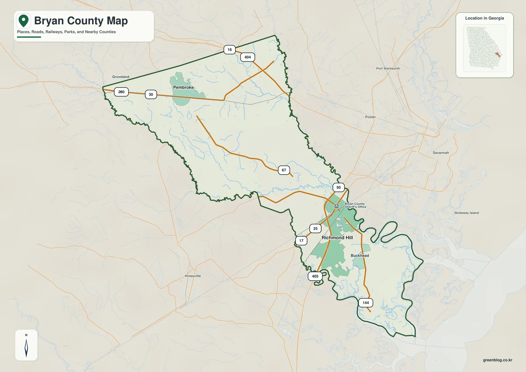
Nearby place names around the map add useful regional context. Groveland lies to the northwest, while Pooler, Port Wentworth, and Savannah appear on the eastern side of the frame. Hinesville is visible southwest of the lower county. These labels are not a complete list of neighboring communities, but they make the county’s position within southeast Georgia easier to grasp. Someone traveling from Savannah to Richmond Hill is approaching a very different part of Bryan County than someone arriving at Pembroke from inland Georgia.
The existing article included in the package explains that Fort Stewart occupies a large part of the county’s middle and helps account for the pronounced separation between upper and lower Bryan County. That context matters when reading the road map. A line that looks direct on a county-scale image may not represent a permitted or practical route through the military reservation. Gate access, closures, and travel restrictions should therefore be checked with current Fort Stewart information rather than inferred from this map.
| State | Georgia |
|---|---|
| County | Bryan County |
| County seat | Pembroke |
| Major cities shown | Richmond Hill and Pembroke |
| Created | December 19, 1793 |
| 2020 census population | 44,738 |
| 2025 population estimate | 52,062 |
| 2020 land area | 437.56 square miles |
| County FIPS code | 13029 |
| Mapped elevation range | About -2 to 48 m; mean 13 m |
| Download | ZIP with four high-resolution A3 JPG maps |
The historical and population values in the table come from the source material supplied in the ZIP. The 2020 census count was 44,738, while the packaged article lists a July 1, 2025 estimate of 52,062. That increase is useful context for a map page because growth extends beyond the two city labels. A countywide map should not be read as if all residents are concentrated inside Richmond Hill and Pembroke municipal limits; unincorporated areas and newer development also make up a substantial part of the county.
A city map that makes the north-south split immediately visible
The city version removes much of the road detail and ranks two major places. Richmond Hill is marked as number 1 in the southern section, and Pembroke is number 2 in the north. The CITY INDEX prints values of 18,181 for Richmond Hill and 2,693 for Pembroke. Because the preview does not identify the year or statistical definition behind those numbers, they are best treated as map-panel reference values rather than asserted as the latest official population totals.
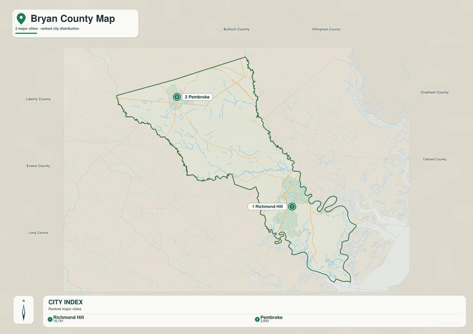
County names around the frame—such as Liberty, Evans, Long, Bulloch, Effingham, and Chatham—help show why the two cities connect to different surrounding areas. Richmond Hill is oriented toward the Savannah and Chatham County side, while Pembroke is positioned toward the inland county network. The picture is especially useful in a classroom or overview document because it communicates that contrast without asking the reader to sort through dozens of minor road labels.
The earlier Bryan County article also mentions unincorporated communities such as Ellabell, Blitchton, and Keller. Their absence from this city map is intentional rather than evidence that they do not exist. The map is designed to rank the major city markers. For a specific address, school, subdivision, or smaller community, use this map to identify the broad part of the county first, then move to a detailed road layer or Bryan County GIS.
From Canoochee River tributaries to tidal rivers and Ossabaw Sound
The water map changes the emphasis completely. In upper Bryan County, a fine network of small streams spreads across the interior. Mill Creek and Haarley Lake are labeled near the north, while Milligan Branch and Savage Creek appear farther south. Clyde Creek leads toward the Canoochee River, one of the strongest inland reference names on the map. These blue lines explain why the interior is not simply blank rural land between Pembroke and the coast.
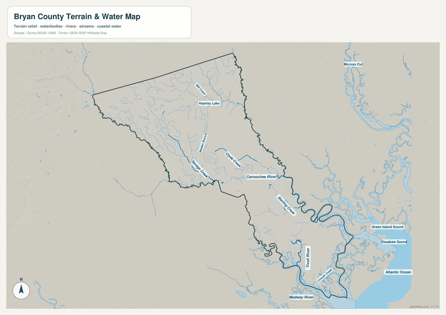
Lower Bryan County has a much more intricate water pattern. Sterling Creek is labeled along the eastern side of the county, and farther south the Tivoli River and Lincoln Creek run through low coastal ground. The Medway River forms a major feature near the bottom of the map. Green Island Sound and Ossabaw Sound are labeled to the east, followed by the Atlantic Ocean. The transition from narrow inland tributaries to broad tidal water is one of the most useful differences visible across the four supplied maps.
The source article also identifies the Ogeechee River and coastal marshes as important parts of Bryan County’s southern geography. Not every wetland boundary or flood-hazard zone is drawn on this preview, so a blue creek line should not be interpreted as a FEMA flood boundary. The water map is suitable for explaining where named rivers, creeks, and sounds lie. Property insurance, evacuation planning, boating access, and flood-risk decisions require current agency products that contain the appropriate legal or hazard layers.
A practical way to read the map is to choose one named water feature and match it against the other views. Canoochee River gives a reference for the central portion of the county, while the Tivoli and Medway rivers help orient the low southern end. Once the water feature is located, the county map can supply the road pattern and the elevation map can show whether the surrounding ground is relatively high or low. This cross-check is much more informative than treating each image as a separate illustration.
The elevation map shows a clear inland-to-coast descent
The elevation legend reports an actual mapped range of roughly -2 to 48 meters and a mean of 13 meters. The northwest is the highest broad part of the county, rendered in browns and tan shades. Moving southeast through the long county shape, those colors give way to yellow-green and then deeper green. By the time the map reaches Richmond Hill and the coastal rivers, much of the terrain is near the lower end of the local scale.
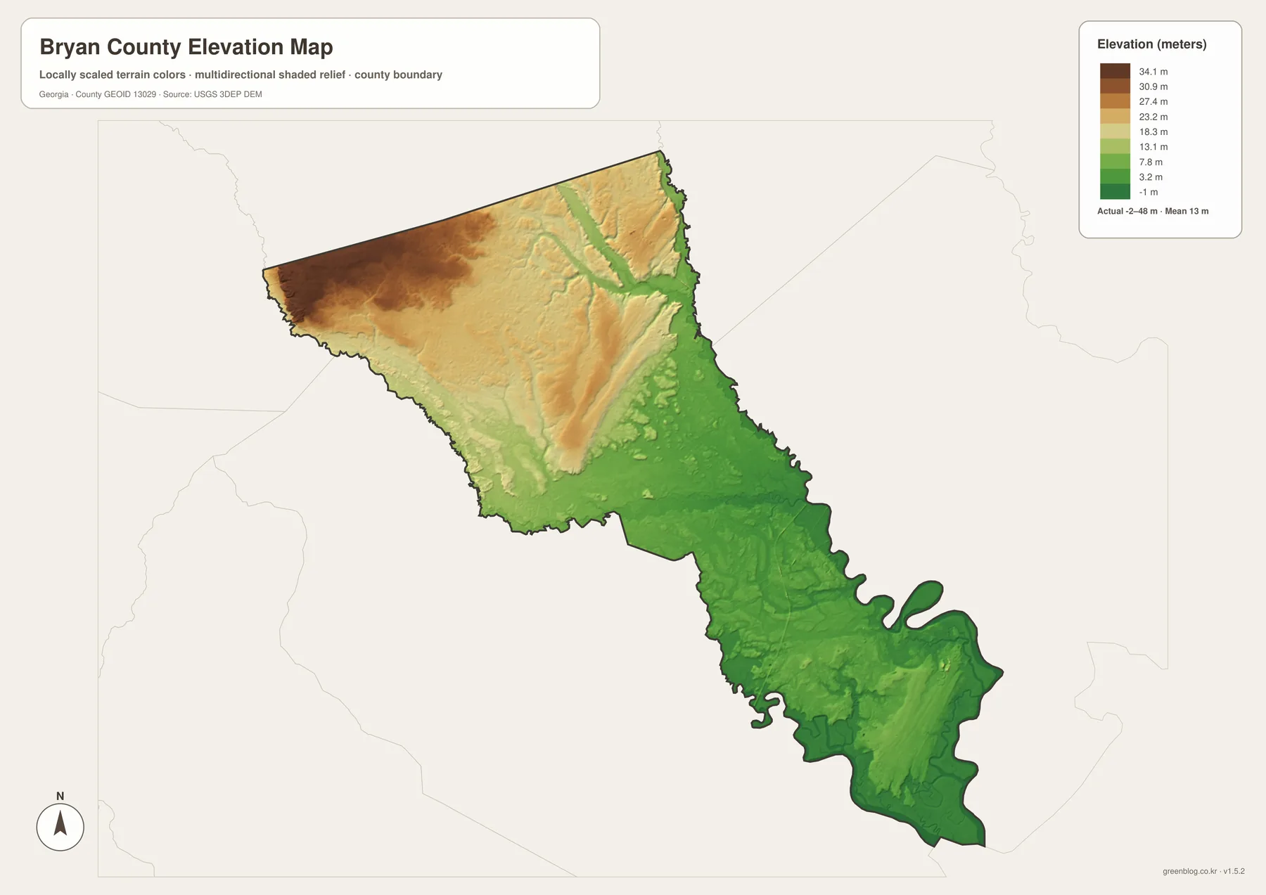
Even in the northern section, the surface is not a single flat plateau. Shaded relief reveals shallow ridges and lower drainage lines, including long green channels cutting through warmer colors. In the south, relief becomes lower and the water network more dominant. Placing the elevation and water maps side by side makes the relationship intuitive: many of the river and creek corridors occupy the low green areas, while the higher ground becomes more continuous toward the northwest.
The -2 meter minimum should be interpreted as part of the elevation dataset and map scale, not as a claim that a particular house or road is permanently below sea level. This is a county-scale shaded-relief map. It is appropriate for geographic comparison, teaching, and broad terrain orientation, but not for surveying a building site, designing drainage, establishing a road grade, or determining a legal flood elevation. Those tasks need current survey or engineering-grade data.
Why upper and lower Bryan County developed around different centers
The existing article in the package provides historical context that helps explain the modern map. Bryan County was created on December 19, 1793, from part of Chatham County, with additional land from Effingham County added in 1794. Pembroke grew with the railroad and naval-stores economy beginning in the late nineteenth century and became the county seat in 1937. Its administrative role therefore developed in the inland section long before today’s coastal growth patterns took shape.
Richmond Hill followed a different history. The packaged source material describes an earlier settlement known as Ways Station and notes Henry Ford’s large land purchases beginning in the 1920s, along with his support for local schools, industry, and health facilities. The community was renamed Richmond Hill in 1941. Its position near the lower Ogeechee area, I-95 corridor, and Savannah side of the county places it in a setting that is both more coastal and more closely tied to the metropolitan road network than Pembroke.
Fort Stewart, established in 1940 according to the supplied article, further strengthened the distinction between the two areas by occupying a large central tract. That history is why a map of Bryan County can look almost like two populated ends connected by a long middle rather than a county organized around one central city. For readers unfamiliar with southeast Georgia, recognizing this pattern early prevents several common mistakes: assuming Pembroke is the largest city because it is the county seat, treating Richmond Hill as a suburb immediately adjacent to Pembroke, or assuming any straight line through the center represents an ordinary public route.
Choose the map by the question you are trying to answer
The four views work best as a small set rather than as competing versions of the same map. Start with the county overview if your question concerns roads, county shape, or the location of Pembroke and Richmond Hill. Switch to the city map when you need the cleanest possible illustration of the two major population centers. Use the water map for named streams, rivers, and coastal sounds, and move to the elevation map when the important question is how inland ground differs from the low coastal plain.
- Use the county map for Pembroke, Richmond Hill, the boundary, and major road corridors such as I-16, I-95, U.S. 280, U.S. 17, and SR 144.
- Use the city map for a simplified north-south comparison of Richmond Hill and Pembroke.
- Use the water map to locate Canoochee River, Sterling Creek, Tivoli River, Medway River, and the coastal sounds.
- Use the elevation map to compare the roughly -2 to 48 m range and the higher northwest with the lower coastal south.
- Use the high-resolution A3 JPG files when a printed handout, poster, slide, or report needs more detail than the WEBP preview.
Keep the original aspect ratio when placing a JPG into a document or slide. The downloadable files are designed to preserve more detail than the web previews, but greater resolution does not change the purpose of the maps. They remain county reference maps rather than live navigation, parcel, military-access, or hazard products. Where a decision depends on a current closure, legal line, flood zone, or surveyed elevation, confirm it with the responsible agency.
What these county maps can and cannot establish
A county-scale map is well suited to orientation. It can show that Pembroke lies in upper Bryan County, Richmond Hill in the south, major roads occupy different corridors, and the coastline is associated with a dense water network and very low relief. It cannot establish parcel ownership, municipal limits at survey precision, school attendance zones, building footprints, installation gate status, or real-time road access. Those layers change for different reasons and should come from the county, state, military, or other official source responsible for them.
The same caution applies to water and elevation. A creek near a property does not by itself prove that the property lies in a regulated flood zone, and a green low-elevation area does not show the depth or probability of flooding. Likewise, higher tan terrain is not automatically safe from drainage or storm impacts. For classroom and regional-reference purposes, the maps make Bryan County’s physical pattern much easier to see. For insurance, construction, evacuation, engineering, or property transactions, use the appropriate current FEMA, county, survey, and engineering data.
Frequently Asked Questions
Which cities are highlighted on the Bryan County city map?
Richmond Hill and Pembroke are the two ranked city markers. Richmond Hill is number 1 in lower Bryan County, and Pembroke is number 2 in the upper section. The map is intentionally simplified and does not label every unincorporated community or local address.
What water features are easiest to locate on the water map?
Canoochee River is a strong inland reference, while Sterling Creek, Tivoli River, and Medway River help orient lower Bryan County. The coastal side also labels Green Island Sound and Ossabaw Sound. Smaller features such as Mill Creek, Savage Creek, and Lincoln Creek add local detail, but the map does not define flood zones.
What is the elevation range shown for Bryan County?
The elevation preview reports an actual mapped range of about -2 to 48 meters and a mean of 13 meters. The northwest is generally higher, while the southern and eastern coastal sections are much lower. These are county-scale terrain values, not survey elevations for individual properties.
Map File Information
Bryan County A3 map files
- Included Files: General county, city, water, and elevation maps
- File Type: Four high-resolution A3 JPG files bundled in one ZIP archive
- Intended Use: Printing, education, presentations, and map-based projects
Related Maps
Sources and references
- U.S. Census Bureau QuickFacts: Bryan County, Georgia — county population and basic statistics
- New Georgia Encyclopedia: Bryan County — county formation, Pembroke, Richmond Hill, and Fort Stewart context
- Georgia Department of Community Affairs: Bryan County, Pembroke, and Richmond Hill plans — local planning documents
- Bryan County Government: Location — county position and major transportation corridors
- USGS National Hydrography — hydrography reference
- USGS 3D Elevation Program — elevation reference
Green Map creates custom-edited map images using open geographic data sources such as geoBoundaries, Natural Earth, OpenStreetMap, and government open data. These maps are edited visual materials, not raw data files, and are provided for education, documents, presentations, and graphic reference.