Bulloch County sits in southeastern Georgia with Statesboro near the center, Interstate 16 along the southern part of the county, and smaller incorporated places spread in several directions. The maps on this page show the county boundary and roads, city relationships, waterways and ponds, and elevation. You can download a ZIP containing all four original A3 high-resolution JPG maps from the download button on this page for printing, classroom work, presentations, or reference use.
The maps are especially useful because Bulloch County changes character from the higher, more dissected ground in the northwest to lower terrain in the southeast. Statesboro provides a practical reference point for the road network, while the Ogeechee River, Mill Creek, Little Lotts Creek, Upper Black Creek, ponds, and other small waterways help explain the landscape beyond the city.
Table of Contents
Statesboro and the county-wide road pattern
The county overview places Statesboro in the middle of a broad county outline. Portal appears northwest of the city, Brooklet southeast, and Register southwest. Nearby labels outside the boundary, including Metter, Guyton, Springfield, Pembroke, and Bloomingdale, provide extra orientation without turning the map into a regional road atlas.
Several major routes converge around Statesboro. U.S. 301 crosses the central area, while State Routes 24 and 67 also pass through or near the city. U.S. 80 and State Route 46 are visible elsewhere in the county, and Interstate 16 runs east-west across the southern portion. That combination makes the overview useful for seeing how the county seat relates to the interstate corridor and to smaller communities in different directions. It is still a reference map rather than a navigation product, so current turn-by-turn routing should come from an up-to-date road source.
How Portal, Brooklet, and Register relate to Statesboro
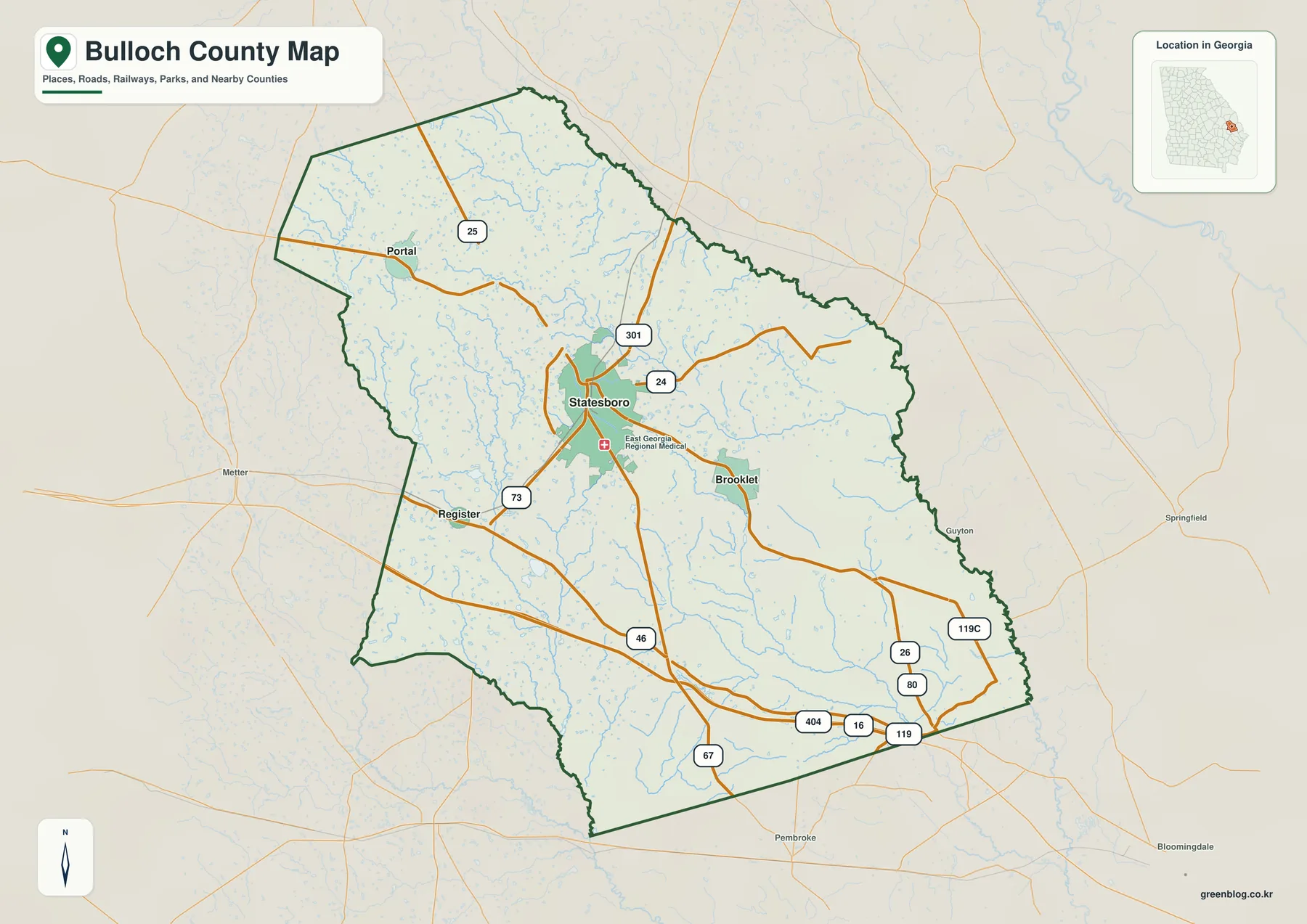
The city-connection map strips away much of the background detail and uses Statesboro as the hub. Brooklet lies about 7 miles southeast of Statesboro, Register about 8 miles southwest, and Portal about 11 miles northwest. Those figures are direct straight-line distances between the mapped points, not driving distances along the road network.
The panel also gives a sense of relative settlement size. Statesboro is listed at 34,149 people, compared with 2,288 for Brooklet, 646 for Portal, and 195 for Register. The numbers are useful as map context rather than as a substitute for the latest Census release. What matters visually is the strong contrast between the large central hub and the three much smaller incorporated places.
County names around the outside add another layer of orientation. Screven and Emanuel counties are shown to the north, Candler and Evans to the west, Bryan to the southwest, and Effingham and Jenkins to the east. This makes it easier to understand why a trip from one edge of Bulloch County to another can cross a sizable rural area even when the destination is still within the same county.
Ogeechee River, creeks, ponds, and low ground
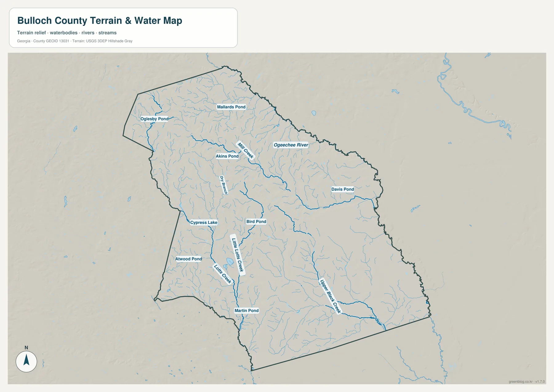
The water map reveals a much denser network than the general county map. The Ogeechee River is the largest named river on the sheet, while Mill Creek cuts through the north-central part of the county. Dry Branch, Little Lotts Creek, Lotts Creek, and Upper Black Creek add smaller drainage lines that become easier to follow against the shaded terrain.
Named ponds and lakes are spread through several parts of the county. Oglesby Pond and Mallards Pond appear in the north, Akins Pond lies farther south, and Davis Pond is toward the east. Cypress Lake, Bird Pond, Atwood Pond, and Martin Pond are also labeled. Together these features show why Bulloch County should not be imagined as featureless flat land: small channels, depressions, and wet areas break up the surface across a wide area.
Upper Black Creek is especially noticeable in the southeastern part of the map, where its bends cross lower terrain. Looking at that area beside the elevation map helps connect stream location with the broad fall in elevation toward the southeast. This water sheet is not a flood-insurance map, parcel map, legal water-boundary map, or navigation chart. Flood risk, access rights, and detailed channel conditions require specialized official data.
A gradual drop from the northwest toward the southeast
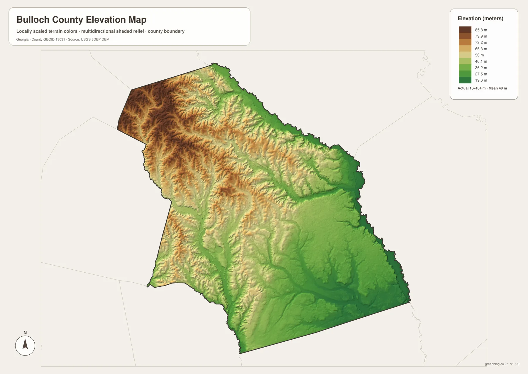
The elevation map reports an actual county range of about 10 to 104 meters, with a mean of roughly 48 meters. Brown and tan shades dominate much of the northwest and western interior, marking the higher ground. Green becomes more common toward the east and southeast, where the terrain is lower.
The relief is subtle compared with a mountain county, but it is not uniform. Shaded ridges and shallow valleys are visible through the northern and western half, while the southeastern surface looks broader and lower. Statesboro falls between the two extremes, which fits its central position on the other maps.
Water and elevation are most informative when read together. The southeastern drainage around Upper Black Creek occupies lower ground, while the Portal side of the county sits closer to the higher northwestern terrain. The elevation surface is generalized for county-scale viewing; it should not be treated as survey-grade elevation for construction, drainage design, or a specific property. USGS 3DEP data or a professional survey is more appropriate for those uses.
Where Bulloch County fits in southeastern Georgia
Bulloch County is inland, west of the Savannah area, within Georgia’s Atlantic Coastal Plain. Interstate 16 provides the clearest regional route on the map, connecting the southern part of the county with the Savannah direction to the east and central Georgia to the west. Roads running south from Statesboro meet this interstate corridor, which helps explain the county seat’s connection to both local rural roads and longer-distance travel.
The county boundary is irregular in the north and east and straighter along several southern segments. On the city map, adjacent counties frame Bulloch County from almost every direction. These outlines are useful for orientation, but anyone checking whether a property, school, utility area, or mailing address falls inside Bulloch County should use a current authoritative boundary layer such as Census TIGER/Line or the county GIS.
The combination of a large inland area, one dominant central city, and an interstate near the southern edge produces a different map pattern from a compact suburban county. Much of the space between incorporated places remains rural, so a county-wide map is useful precisely because city labels alone do not describe all of the land between them.
County seat, history, and the role of Statesboro
Bulloch County was created on February 8, 1796, from parts of Bryan and Screven counties. Its name honors Archibald Bulloch, a Revolutionary-era Georgia political leader. Portions of the original county were later used in the formation of surrounding counties, including Candler, Emanuel, Evans, and Jenkins, which helps explain the present-day ring of neighboring jurisdictions seen around the map.
Statesboro developed as the county seat and remains the largest incorporated place in the county. The city is also closely associated with Georgia Southern University, whose main campus is in southern Statesboro. The university is not drawn as a separate boundary on these four maps, but it is important background when considering the city’s housing, traffic, services, and population.
The existing county source material records 81,099 residents in the 2020 census and a July 1, 2025 estimate of 86,949. Land area for 2020 is listed at 675.96 square miles. Those figures help explain why the county can have a substantial population while still showing extensive rural space outside Statesboro. Population estimates are revised over time, so the current Census QuickFacts page should be used when a project requires the newest figure.
Historical accounts also describe the growth of Statesboro through agriculture, timber-related trade, rail connections, and education. That background is useful when looking at the present road map: the modern hub is not simply a point placed in the middle of the county, but the long-standing administrative and service center around which many routes converge.
Choosing the right Bulloch County map
Use the county overview when the main question is location. It combines the boundary, Statesboro, smaller cities, major roads, and a light water layer, so it works well as the first map in a report or lesson. If the question is how far Portal, Brooklet, or Register sits from Statesboro, the city-connection sheet removes extra detail and makes those direct distances easier to compare.
Choose the water map when rivers, creeks, ponds, or drainage are central to the topic. It gives the Ogeechee River and smaller named waters enough prominence to follow them across the county. The elevation sheet is the better companion for explaining why some of those channels occupy lower ground and how the higher northwest differs from the southeast.
For print, a large monitor, or a presentation where labels need to stay crisp, the A3 JPG files in the ZIP are preferable to the smaller WEBP previews embedded in the article. Keep the original aspect ratio when resizing. The maps are county-scale reference products, so parcel decisions, flood determinations, engineering measurements, or legal boundary questions require the appropriate specialized source.
Frequently Asked Questions
Where is Statesboro within Bulloch County?
Statesboro is near the center of the county and serves as the county seat. Several major routes converge around it on the overview, and the city-connection map uses Statesboro as the reference point for Brooklet, Register, and Portal.
Are the city distances driving distances?
No. The city map shows direct straight-line distances from Statesboro: about 7 miles to Brooklet, 8 miles to Register, and 11 miles to Portal. Actual driving distances depend on the route and will normally be longer.
What elevation range is shown for Bulloch County?
The elevation map shows an actual range of about 10 to 104 meters and a mean near 48 meters. Higher ground is concentrated mainly in the northwest and west, while the east and southeast are generally lower. These are county-scale reference values rather than property-survey elevations.
Map File Information
Download the original Bulloch County county, city-connection, waterways, and elevation maps together in one ZIP.
- Included Files: Four A3 high-resolution JPG maps
- File Type: JPG files in one ZIP archive
- Intended Use: Printing, education, presentations, and map-based projects
Related Maps
Sources and reference data
Population and county statistics can be checked through the U.S. Census Bureau QuickFacts page for Bulloch County, Georgia. Boundary reference data are available from U.S. Census Bureau TIGER/Line Shapefiles, water data from USGS National Hydrography, and elevation data from the USGS 3D Elevation Program.
For additional county background, see the New Georgia Encyclopedia entry on Bulloch County and the county’s SMART BULLOCH 2045 Joint Comprehensive Plan.
Green Map creates custom-edited map images using open geographic data sources such as geoBoundaries, Natural Earth, OpenStreetMap, and government open data. These maps are edited visual materials, not raw data files, and are provided for education, documents, presentations, and graphic reference.