This Nebraska Map shows why the state cannot be reduced to a simple rectangle. A long western Panhandle extends toward Wyoming, the main body forms a broad county grid, and the eastern edge becomes irregular along the river boundary. Fitting all 93 county names into that shape requires very different label spacing from Sioux and Kimball in the west to Dakota and Richardson in the east.
Nebraska borders six states, but the supplied labeled artwork names only four: South Dakota above, Iowa to the east, Kansas below, and Colorado southwest of the Panhandle. Wyoming and Missouri are not named. The page is therefore best read as a Nebraska county reference with partial surrounding context rather than a complete neighboring-state diagram.
The collection provides a pastel labeled map, a black-and-white labeled version, and an unlabeled county outline. All three Nebraska Map previews measure 1200 × 848 pixels and share the same landscape geometry. They can be used together as a completed reference, a neutral print sheet, and a blank identification exercise without changing the position of any county.
Table of Contents
Nebraska Map Overview
Nebraska has 93 counties, and both labeled versions place every name inside its boundary. The western Panhandle includes Sioux at the far northwest, Kimball at the southwest corner, and counties such as Dawes, Box Butte, Scotts Bluff, Morrill, Banner, Cheyenne, Deuel, Garden, and Sheridan between them. Many of these shapes are larger and less crowded than those along the eastern edge.
Cherry dominates the north-central part of the map as a broad horizontal county. Directly south, Grant, Hooker, Thomas, Blaine, Loup, Garfield, and Wheeler form a narrow sequence of smaller areas. Custer occupies another large central shape, while Lincoln County extends across the west-central tier below it. These size contrasts interrupt the regular grid and help orient readers before they study individual names.
County spacing becomes tighter toward the northeast and east. Knox, Cedar, Dixon, Dakota, Pierce, Wayne, Thurston, Madison, Stanton, Cuming, and Burt fill the upper-right area. Washington is narrow enough that its label is set diagonally, and Douglas and Sarpy are stacked beneath it near the edge. Farther south, Cass, Otoe, Nemaha, Johnson, Pawnee, and Richardson follow the irregular state boundary.
This Nebraska Map does not mark the state capital or any city. The word “Lincoln” in the west-central area identifies Lincoln County; it is not a point for the city of Lincoln, which lies in Lancaster County. Omaha is also absent, although Douglas County is labeled. Roads, rivers, county seats, terrain, a scale bar, a north arrow, and statistical symbols are not included.
The nearly straight southern row is another practical reference line. Dundy, Hitchcock, Red Willow, Furnas, Harlan, Franklin, Webster, Nuckolls, Thayer, Jefferson, Gage, Pawnee, and Richardson lead from the Colorado side toward the southeast corner, with several counties positioned just above them. This arrangement makes the bottom edge useful for a west-to-east labeling exercise.
Included Map Versions
The three maps use the same county boundaries but provide distinct levels of guidance. The color edition separates neighboring areas, the monochrome edition retains all names on white interiors, and the outline removes county and surrounding-state labels. Each Nebraska Map keeps the page title, “Nebraska County Boundaries Guide” subtitle, internal lines, gray exterior, and site mark.
- Color reference: 93 labeled counties in alternating pastel fills, plus four surrounding-state names.
- Black-and-white reference: the same names and geometry with white county interiors.
- Blank outline: all county boundaries without county names or neighboring-state labels.
The files were prepared for high-resolution A3 use. The supplied previews are WebP images, while the protected ZIP should be described conservatively as an archive of image files rather than as a vector, GIS, or editable source package. The maps show an administrative arrangement, not a legal survey or navigation layer.
Color Nebraska County Map
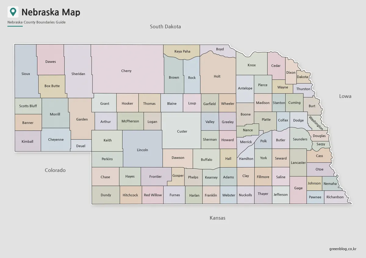
The color Nebraska Map makes adjacent boundaries easier to follow without changing the underlying county network. Pastel fills distinguish the tall western shapes around Sioux and Sheridan, clarify the compact row between Grant and Wheeler, and separate the dense group around Douglas, Sarpy, Cass, and Otoe. The colors also keep narrow counties such as Washington from disappearing into neighboring lines.
No thematic meaning is assigned to the palette. A peach, blue, green, or lavender fill does not indicate population, agriculture, elevation, voting, or regional membership, and the map has no quantitative legend. Presenters should use the colors only as visual separators unless they add a cited dataset, reference date, and explanatory key.
This version is the clearest choice for introducing the 93-county framework on a slide or screen. A reader can begin with the Panhandle, move across Cherry and Custer, and finish with the smaller eastern counties. That sequence uses Nebraska’s actual visual pattern rather than asking viewers to search a crowded page at random.
Black and White Printable Version
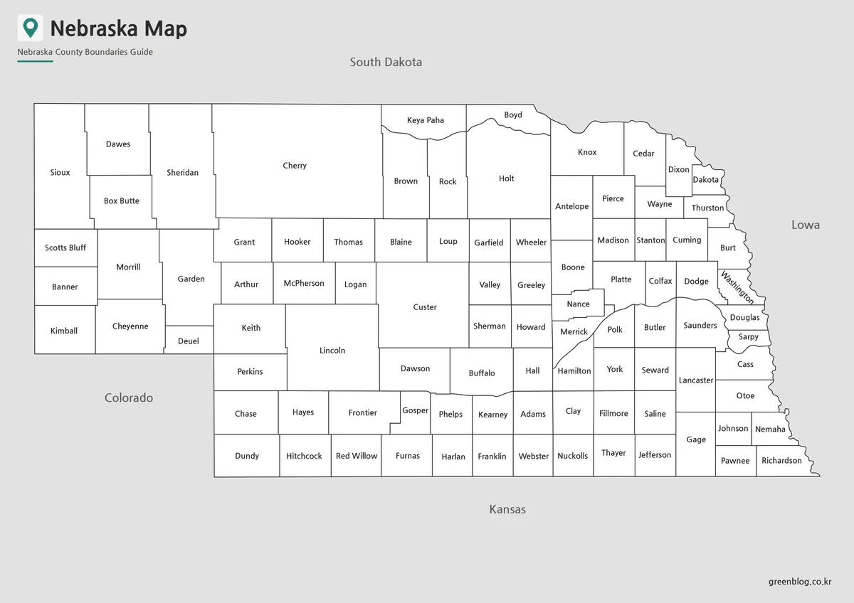
Removing the pastel fills shifts attention to spelling, label position, and shared borders. The broad western counties remain easy to scan, while the clean white interiors reduce competition around small labels such as Stanton, Colfax, Nance, Polk, Johnson, and Nemaha. Washington’s diagonal name remains visible, preserving the solution used for that narrow eastern shape.
The monochrome map is suitable for a printed county directory, a worksheet answer key, or a report that needs a neutral administrative figure. Users can circle a study area or shade selected counties by hand while retaining the names. When reducing the page below its landscape proportions, inspect the eastern counties first because their labels have the least surrounding space.
Blank Nebraska Outline Map for Editing
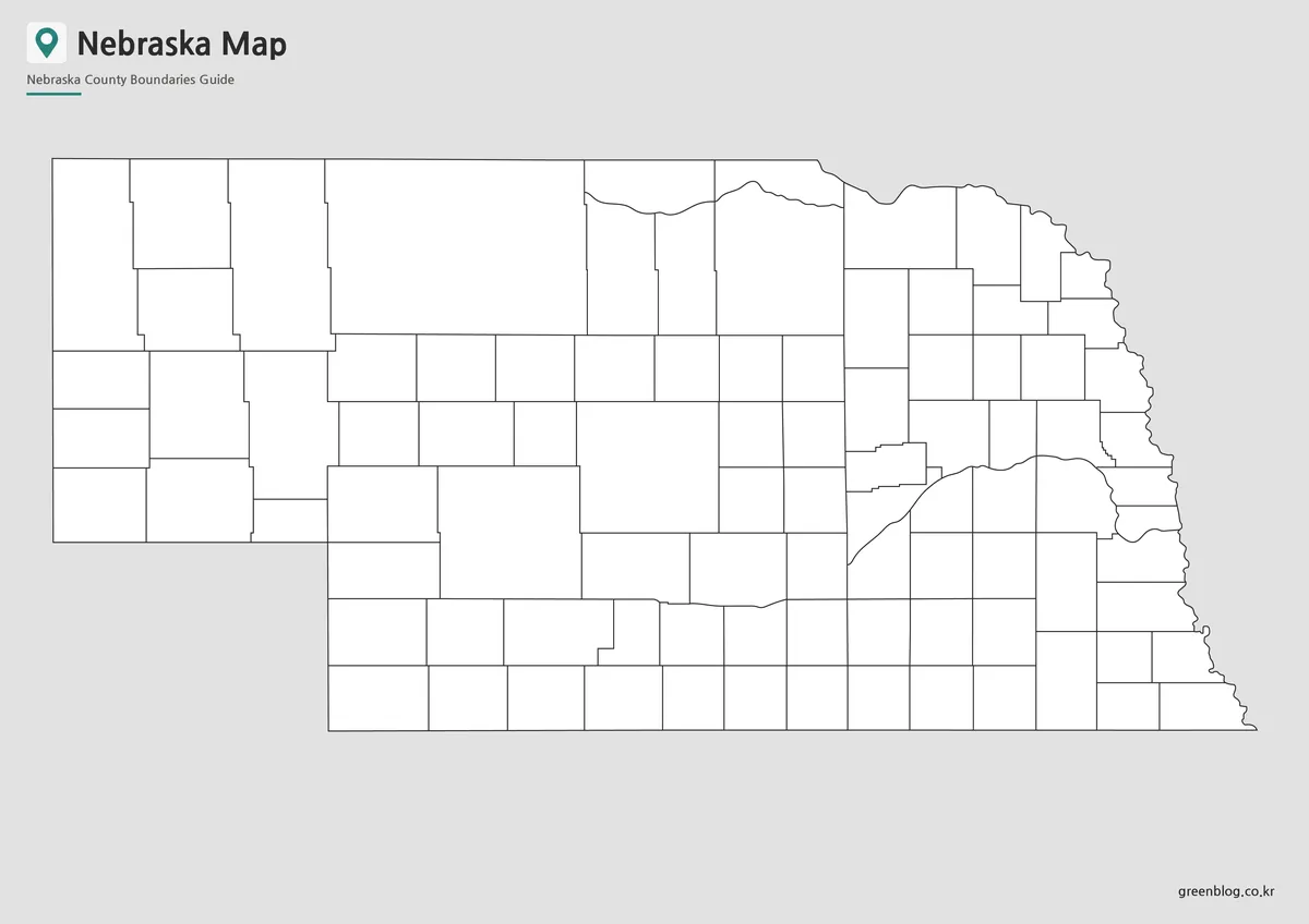
The outline edition removes all 93 county names and the four surrounding-state labels. It retains the county lines, state silhouette, title, subtitle, gray exterior, and site mark, so it is blank for instructional purposes rather than a border-only drawing. The Panhandle and the irregular eastern edge remain strong orientation cues even without text.
Teachers can ask students to label the Panhandle counties, identify Cherry and Custer by shape, or complete the southern row from Dundy to Richardson. Designers can add verified city points, routes, values, or county groupings with a separate legend. Because the preview is a raster image, it should not be advertised as a vector or GIS file, and detailed overlays may require a more specialized base.
Practical Uses for This Nebraska Map
For a structured lesson, show the color reference first, distribute the outline for labeling, and reserve the monochrome sheet as an answer key. Dividing the task into Panhandle, north-central, south-central, northeastern, and southeastern groups makes 93 names more manageable. It also draws attention to the contrast between large rural county shapes and the tighter administrative pattern near the eastern boundary.
Choose the color version when neighboring counties must be distinguished quickly on a screen. Use monochrome when names need to remain present in a low-color document. Select the outline when the reader should supply labels or when a project needs its own sourced categories, but explain that city locations and physical features have been added separately.
For A3 output, preserve the 1200 × 848 landscape ratio and print a test page before making a class set. Check Washington’s angled label, the small county group around Douglas and Sarpy, and the short names along the southern border. A page that keeps those details legible will also handle the larger central and western labels comfortably.
Frequently Asked Questions
Is this Nebraska Map suitable for A3 printing?
Yes. This Nebraska Map was prepared for A3 high-resolution use, so it works well for classroom materials, presentation boards, and printed reference sheets.
Which version should I use first?
Use the color map if you want to understand the county layout quickly. The color separation makes the regional structure easier to scan.
Which Nebraska map is best for printing?
The black and white version is usually best for printed handouts, reports, and worksheets because it keeps the county labels clear while reducing color use.
Can I edit the outline map?
Yes. The blank outline map is suitable for adding county colors, data marks, travel routes, labels, or infographic elements.
Does the map include detailed roads or facilities?
No. The map focuses on county boundaries and labels rather than roads or facility locations, which keeps the layout cleaner for educational and presentation use.
Map File Information
The archive contains the three Nebraska county views displayed above for printing, reference, labeling, and custom graphics.
- Included Versions: Color labeled, black-and-white labeled, and blank outline maps
- Printable Size: A3 high resolution
- File Type: Image files in a ZIP archive
- Intended Use: Lessons, answer keys, reports, slides, annotations, and design projects
Related Maps
Additional Resources
The Nebraska Legislature’s county map page provides an official outline reference with downloadable image and document options.
Green Map creates custom-edited map images using open geographic data sources such as geoBoundaries, Natural Earth, OpenStreetMap, and government open data. These maps are edited visual materials, not raw data files, and are provided for education, documents, presentations, and graphic reference.