Runnels County Texas map|Ballinger, farm country, and the Colorado River corridor

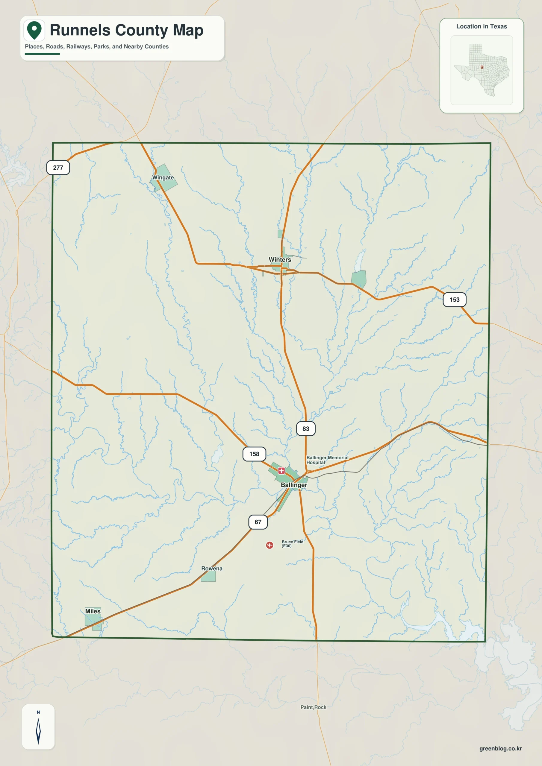
A traveler following U.S. 83 north from San Angelo enters a broad agricultural landscape where Ballinger and Winters serve as the principal community anchors. This Runnels County Texas map provides a printable reference for that part of West Central Texas, including Miles, Rowena, Wingate, Norton, the neighboring county pattern, and selected water features. The county seat is Ballinger, but local activity is distributed across several small towns rather than concentrated in one large urban center.

Runnels County covered 1,051.07 square miles of land and only 6.03 square miles of water in the supplied geographic record. Its estimated population was 9,751 in 2024, a decrease of 170 residents from 2020. Those figures fit the county’s strongly rural settlement pattern: extensive farmland and ranchland separate compact towns, highway junctions, reservoirs, and service centers.

Highways connect separate community centers

Ballinger occupies a strategic junction of U.S. 67, U.S. 83, and State Highway 158. The Colorado River and Elm Creek meet nearby, and the town developed into the county’s government, shipping, and distribution center. U.S. 83 continues north to Winters, creating a direct connection between the county seat and the second major town in the county.

The southwestern corridor follows U.S. 67 through Rowena and Miles toward Tom Green County and San Angelo. Smaller communities such as Wingate and Norton provide reference points across the northern and eastern countryside. A county map is especially useful here because distances between towns are greater than their small population totals might suggest, and many destinations are identified by highways, farm roads, or nearby creeks rather than dense street networks.

A county created before it was organized

The Texas Legislature established Runnels County in 1858 and named it for Hiram G. Runnels, a former Mississippi governor who later served in the Texas legislature. Permanent settlement remained limited for years, and the county was not formally organized until February 1880. Early cattlemen established camps along the Colorado River and its tributaries as frontier conditions became more stable during the late nineteenth century.

Runnels City was chosen as the first county seat on Elm Creek. Its position reflected the settlement pattern of the time, but rail construction soon introduced a stronger competitor. The Gulf, Colorado and Santa Fe Railway created a new terminal town in 1886 at a site with a better water supply, laying out courthouse space and a public square before selling town lots.

Why Ballinger replaced Runnels City

The new rail town, eventually named Ballinger, attracted residents, businesses, and buildings from the original county seat. Ballinger won the county-seat contest in 1888, and the courthouse was constructed in 1888–89 on a two-block square reserved by the railroad. The courthouse location at U.S. 67 and U.S. 83 still marks the administrative center of the county.

This transition is one of the clearest examples of transportation and water supply reshaping local geography. Runnels City declined after the move, while Ballinger became the dominant distribution point. The present map therefore combines modern place labels with a county layout whose central hierarchy was largely established by an 1880s railroad decision.

Cotton, drought, and a diversified rural economy

Ranching dominated the early settlement period, but farming expanded rapidly after 1900. Cotton became the leading crop as immigrants and farm families converted large areas of grassland into cultivated acreage. The county population rose sharply during that agricultural boom, and towns developed gins, grain businesses, supply stores, and shipping facilities tied to farm production.

The drought of 1916–18 exposed the risks of a crop-dependent economy. Cotton output collapsed, indebted farmers lost property, and both population and farm numbers fell. Later decades brought manufacturing, trade, services, and oil and gas activity into the economic mix, although agriculture continued to shape the landscape and the spacing of communities.

Water features with outsized local importance

Water occupies less than one percent of the county’s mapped area, yet a few features carry major practical value. The Colorado River crosses the county’s southern portion and passes near Ballinger. Ballinger Lake, about four miles northwest of the city on Valley Creek, was developed for municipal water supply and recreation and is the largest lake located within Runnels County.

The reservoir supplies Ballinger as well as the Rowena and North Runnels water systems. Lake Winters provides another local water and recreation resource farther north. On a Runnels County Texas map, these relatively small water bodies help explain why towns, roads, and public services developed where they did in an otherwise dry and expansive landscape.

Color Map

The color edition separates Runnels County from Taylor, Coleman, Concho, Tom Green, Coke, and Nolan counties. Begin with Ballinger at the central highway junction, then follow U.S. 83 toward Winters or trace the U.S. 67 corridor through Rowena and Miles. Distinct fills help users read the county’s position between the Abilene and San Angelo regions without losing the smaller community labels.

Color map showing Ballinger, Winters, Miles, Rowena, and Runnels County boundaries
A color-separated county reference map for the Ballinger and Winters area

Black-and-White Map

The monochrome map retains selected names and boundary lines while removing colored areas. It is suitable for county profiles, property research notes, school handouts, and travel documents where clean reproduction matters more than visual category colors. Users can add route numbers or circle a community without covering a dark background.

Printable black-and-white map of Runnels County with selected community labels
Monochrome county map prepared for reports, handouts, and classroom printing

Outline Map

The outline version is designed as an open working base. It can be labeled with Ballinger as the county seat, Winters as the northern center, the Colorado River, Ballinger Lake, Lake Winters, or a custom set of farm-to-market roads. The simplified linework also supports historical exercises comparing Runnels City with the later Ballinger-centered pattern.

Blank outline map of Runnels County and included internal boundaries
Unlabeled boundary base for adding highways, towns, rivers, and custom notes

Download the county map set

All three files use an A3 layout. Choose the color map for orientation, the black-and-white map for economical printing, or the outline map for custom labels and route work.

County Map File Information

The download contains color, black-and-white, and outline JPG maps of Runnels County. The first two versions include selected place labels, while the outline file removes labels and fills for custom work.

  • Included Versions: Color, Black and White, Outline
  • File Type: JPG
  • Printable Size: A3 layout
  • Map Coverage: County boundary, included local boundaries, and surrounding county context
  • Suggested Uses: Reports, classroom activities, regional planning notes, travel references, and blog graphics
Download Runnels County Map Files

Frequently Asked Questions

What is the main road connection between Ballinger and Winters?

U.S. Highway 83 links Ballinger with Winters and continues north toward Taylor County. It forms the clearest north–south community axis in the county.

What happened to the original county seat?

Runnels City served as the first county seat, but Ballinger gained the railroad terminal, a better water supply, and the county-seat election in 1888. Runnels City declined after government and residents shifted south.

Does the map include every rural road?

The base maps focus on county boundaries, selected community names, and regional context. Detailed farm roads or local routes can be added to the outline edition for a specific project.

Sources and official references

Green Map creates custom-edited map images using open geographic data sources such as geoBoundaries, Natural Earth, OpenStreetMap, and government open data.

These maps are edited visual materials, not raw data files, and are provided for education, documents, presentations, and graphic reference.
Leave a Comment

Your email address will not be published. Required fields are marked *

Scroll to Top