You can download the Warren County map set on this page as a ZIP containing four high-resolution A3 JPG files. McMinnville is the clearest road and settlement center, while Morrison lies to the southwest, Centertown to the west, and Viola to the south. The physical maps add an important second layer: Collins River and Barren Fork occupy lower corridors through the county, while the southeastern corner rises sharply into much higher terrain.
The general map shows several numbered routes converging on McMinnville, including the 1/70 corridor and routes 30, 55, 8, 56, 108, 127, 287, and 288. The city map compares four settlements and their direct distances from McMinnville. The water map labels Collins River, Barren Fork, Mountain Creek, Charles Creek, and several smaller lakes and branches. Elevation ranges from about 193 to 605 meters, with a mean near 338 meters.
Table of Contents
McMinnville sits at the county’s strongest road junction
McMinnville occupies a central position on the county map and is surrounded by the densest concentration of roads and mapped development. That makes it the best place to begin orientation. Centertown lies west of the city, Morrison is farther southwest, and Viola is near the southern edge. Those three outer settlements make it clear that Warren County is not organized around one circular urban footprint; its communities extend along several different road and valley directions.
East of McMinnville, the 1 and 70 route labels share the main corridor before 30 continues farther toward the eastern boundary. Route 55 links the southwest toward Morrison, while 108 and 127 provide references around Viola. Route 8 reaches the southeastern side, 56 descends toward the southern edge, and 287 and 288 help orient the northwest and north. Many of these roads bend with the terrain instead of forming a rigid grid.
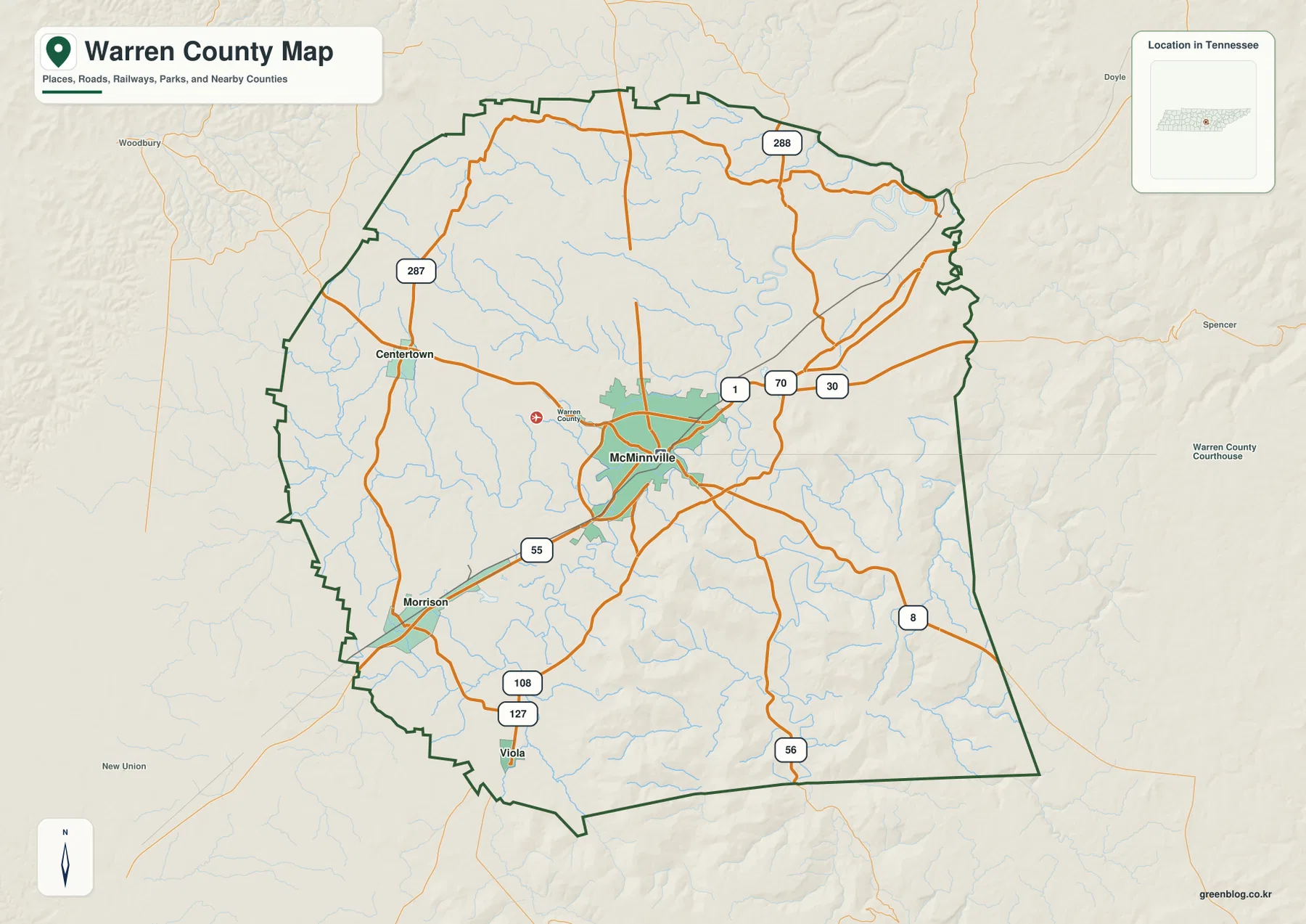
Outside reference labels such as Woodbury, Spencer, and New Union help establish direction without becoming part of the county itself. The supplied county material identifies DeKalb, White, Van Buren, Sequatchie, Grundy, Coffee, and Cannon counties as neighbors. When a road or place name appears close to the green county boundary, the boundary line should be checked before assuming that the feature lies inside Warren County.
Four settlement labels show different directions from McMinnville
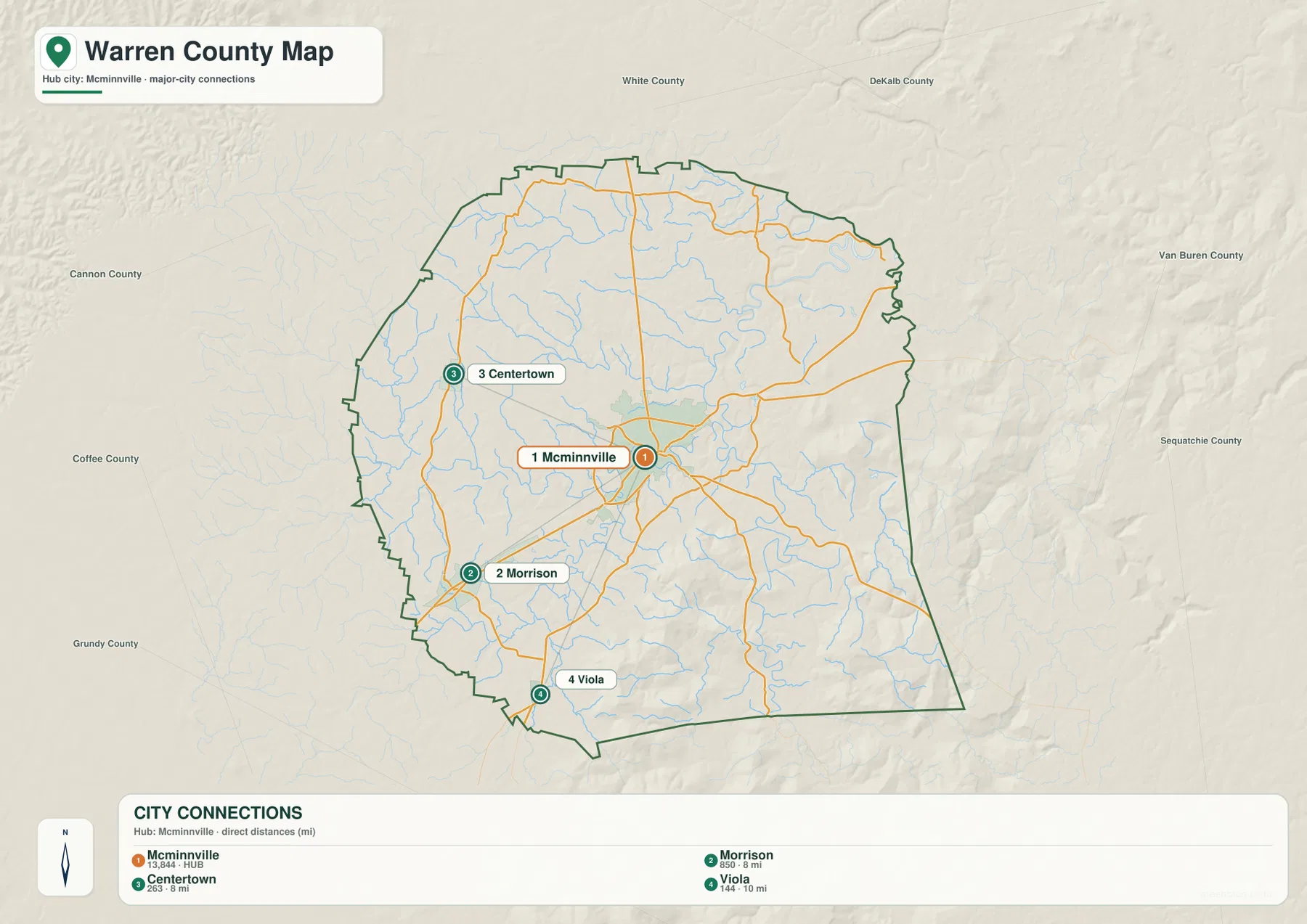
The city-connections map uses McMinnville as its hub and lists four places. McMinnville is labeled at 13,844, Morrison at 850, Centertown at 263, and Viola at 144. Morrison and Centertown are each shown about 8 miles from McMinnville by direct distance, while Viola is about 10 miles away. These values belong to the supplied city graphic and should not be treated as driving distances or as a current official population table.
The direction of each point is as informative as the numbers. Centertown is west of the hub, Morrison is southwest, and Viola is south. Morrison has a relatively direct road connection along the 55 corridor, while the southern approach toward Viola passes through a more broken landscape of creeks and hills. For practical movement, the county road map provides more useful context than a straight-line connector alone.
The countywide scale is much larger than these four labels. Existing reference data gives a 2020 census population of 40,953 and a July 2025 estimate of 43,717, with about 432.7 square miles of land and 1.4 square miles of water. Dividing the 2020 count by land area gives roughly 94.7 residents per square mile, but the visible concentration around McMinnville and the broad rural uplands make clear that this average is not a neighborhood-density map.
Collins River and Barren Fork organize the central and southern drainage
Collins River is the most prominent watercourse on the terrain-and-water map. It enters from the south, winds northward through the southeastern half, and makes several large bends before continuing through the central drainage network. Barren Fork approaches through the western and central part of the county and occupies a low corridor close to the McMinnville area. Together, these waterways help explain why the central settlement and road network occupies lower ground rather than the highest southeastern ridges.
Mountain Creek is a long northern tributary, and Charles Creek crosses the northwest toward the interior. Dog Branch and Owens Branch are labeled farther west, while Hickory Creek and Dry Branch appear in the southwest. Dry Gulf Creek follows the eastern side. Smaller water bodies such as Lake Karen, Great Falls Lake, Lakeside Lake, and Black Pond provide additional local reference points.
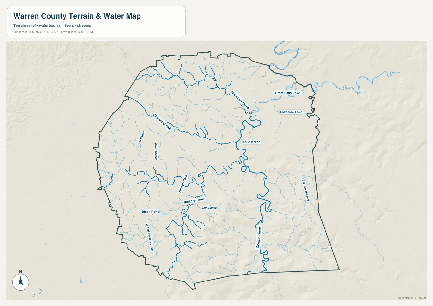
The broader county references also identify Caney Fork and Rocky River as important geographic features in the Warren County setting. On the supplied preview, however, Collins River, Barren Fork, and the labeled creeks are the clearest features for direct map reading. This is a static reference map; it does not provide live river stage, flood extent, channel depth, navigation status, or legal parcel boundaries.
The southeast rises from low river corridors to terrain above 600 meters
The elevation map gives Warren County an actual mapped range of about 193 to 605 meters and a mean near 338 meters. Western and northwestern areas are mostly green and comparatively moderate, while low stream corridors also cut through the central part of the county. The southeast is the clear exception: yellow and brown terrain expands rapidly toward the eastern and southern boundaries.
Several high ridges project westward from the southeastern upland, leaving narrow green drainage valleys between them. The Collins River system follows some of these lower passages. Farther northeast, the terrain is not as high as the southeastern corner but remains deeply dissected by streams. This combination gives Warren County a strong transition from gentler interior and western land to steep, high relief in the southeast.
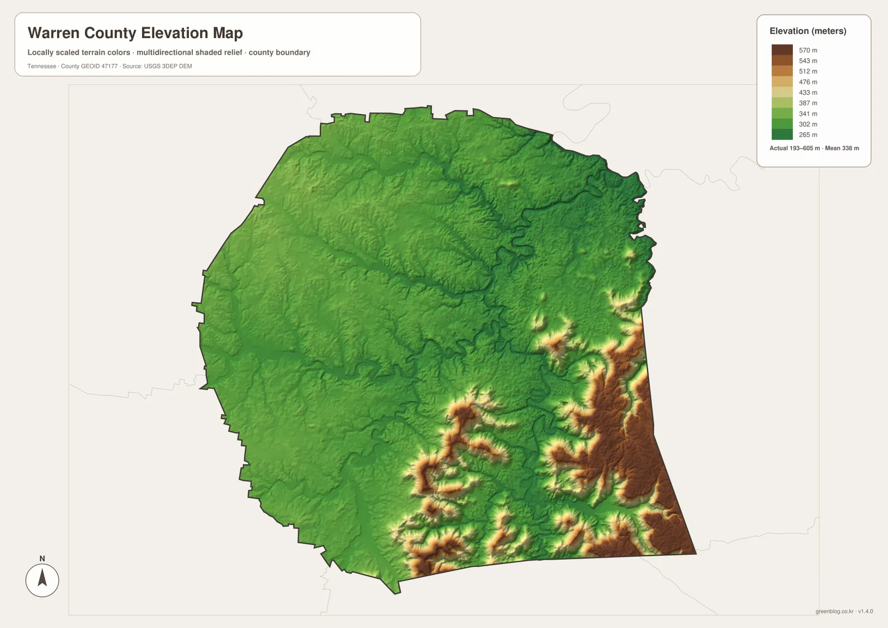
The supplied county material identifies the Highland Rim as part of the regional terrain setting. The elevation map adds county-level detail by showing that the Highland Rim is not uniform here: the southeastern section rises much more sharply than the central and western areas. This generalized elevation surface is useful for broad comparison, not for determining parcel elevations, construction grades, or engineering measurements.
Why roads and settlements favor the lower central corridors
The concentration of roads around McMinnville makes more sense when the water and elevation layers are considered together. The central area is lower and more open than the southeastern highlands, and Barren Fork with the Collins River drainage provides a series of natural corridors. Roads leaving the city often follow those lower routes before bending around higher terrain or crossing streams at practical locations.
The southwest toward Morrison is relatively moderate, but the landscape becomes more broken around Viola and especially farther east and southeast. Routes 8 and 56 therefore cross a different terrain setting from the roads west of McMinnville. Even though water accounts for only a small portion of the county’s total area, a long river or deeply cut creek can still affect where roads cross and how direct a route can be.
Warren County was established in 1807, and McMinnville is the county seat in the supplied reference material. The modern map reflects that administrative role in a practical way because the strongest road concentration is also centered there. Large upland areas outside the city contain fewer major settlement labels, which is why the city layer should always be read alongside the terrain and water maps.
Choosing the Warren County map that fits the question
Use the general county map when you need McMinnville, major roads, Morrison, Centertown, Viola, and the boundary in one view. The city map is a quick way to compare the four settlement labels and their direct distances. The water map is better for Collins River, Barren Fork, Mountain Creek, and other drainage features. The elevation map adds the strongest explanation for why the southeastern road network looks different from the central and western parts of the county.
For printed study or annotation, separate transportation from physical geography instead of marking every feature on one copy. One sheet can emphasize McMinnville and routes 70, 30, 55, 8, and 56. Another can mark Collins River, Barren Fork, Mountain Creek, the lower central valleys, and the southeastern high ground. This keeps the relationship between roads, water, and relief easy to see.
When comparing Warren County with surrounding counties, begin with the county outline and the four internal settlement labels. Add nearby counties only after the boundary is clear, then trace the roads and streams that continue across it. This approach is more reliable than using outside place names as if they were part of Warren County and keeps the map focused on features that are actually shown inside the supplied boundary.
Frequently Asked Questions
How far are Morrison, Centertown, and Viola from McMinnville on the city map?
The supplied city graphic shows Morrison and Centertown at about 8 miles from McMinnville by direct distance and Viola at about 10 miles. These are straight-line comparisons, not driving distances. Actual trips depend on road alignment, stream crossings, and terrain.
Which waterways stand out most on the Warren County water map?
Collins River and Barren Fork are the most prominent central and southern waterways. Mountain Creek and Charles Creek are also easy to follow, and the map labels smaller water bodies such as Lake Karen and Great Falls Lake. The map is intended for location reference rather than current flood or navigation information.
Why is the southeastern corner much higher on the elevation map?
The southeastern part of Warren County contains the county’s strongest concentration of high ridges and upland terrain. The mapped range is about 193 to 605 meters, with a mean near 338 meters, while the central river valleys and much of the west are lower. Parcel-level elevation requires more detailed source data.
Map File Information
The ZIP contains the high-resolution JPG originals for the Warren County map, city map, water map, and elevation map shown on this page. The four A3-format images are better suited to printing, enlarged viewing, and annotation than the WebP previews in the article.
- Included Files: County map, city map, water map, and elevation map
- File Type: ZIP containing 4 JPG images
Related Maps
- Alamo to Gadsden: A Crockett County Tennessee Map
- Altamont, Monteagle, and Plateau Valleys — Grundy County Tennessee Map
- Around Chattanooga: Hamilton County Tennessee Map
Sources and References
- Tennessee State Library and Archives Warren County fact sheet
- Tennessee Department of Transportation Warren County map
- U.S. Census Bureau Warren County QuickFacts
- USGS National Hydrography
- USGS 3D Elevation Program
Green Map creates custom-edited map images using open geographic data sources such as geoBoundaries, Natural Earth, OpenStreetMap, and government open data. These maps are edited visual materials, not raw data files, and are provided for education, documents, presentations, and graphic reference.