Download the high-resolution A3 JPG ZIP for the Grundy County Tennessee Map directly from this page; it includes the county, city, water, and elevation maps shown below. Altamont is the county seat near the north-central part of the county, while Monteagle and Tracy City sit in the south and Gruetli-Laager and Palmer lie farther east. The maps show a county built around high plateau surfaces but cut by much lower valleys along Collins River in the north, Elk River in the southwest, and several smaller creek systems.
Calling Grundy County a plateau county is accurate, but the elevation map shows why that description is incomplete on its own. Much of the center and east remains high, yet river and creek valleys cut deeply into the plateau from several directions. Pelham occupies a particularly low southwestern corridor, while the land rises again toward Monteagle and Tracy City. In the north, Collins River and its tributaries carve another low network into the higher surface around Altamont and Beersheba Springs.
Table of Contents
Monteagle leads the city ranking, while Altamont remains the county seat
The city map ranks six places: Monteagle at 1,926 residents, Tracy City at 1,682, Gruetli-Laager at 1,480, Altamont at 1,322, Coalmont at 906, and Palmer at 818. That order is useful because it separates population rank from government function. Altamont is the county seat even though Monteagle carries the largest population label on this map.
The cities also form distinct geographic groups. Altamont sits in the north-central interior with Beersheba Springs nearby to the northeast. Gruetli-Laager is farther east, Palmer lies close to the eastern boundary, and Coalmont is southwest of them. Tracy City and Monteagle form the southern group, well separated from Altamont by the central plateau and the road network that crosses it.
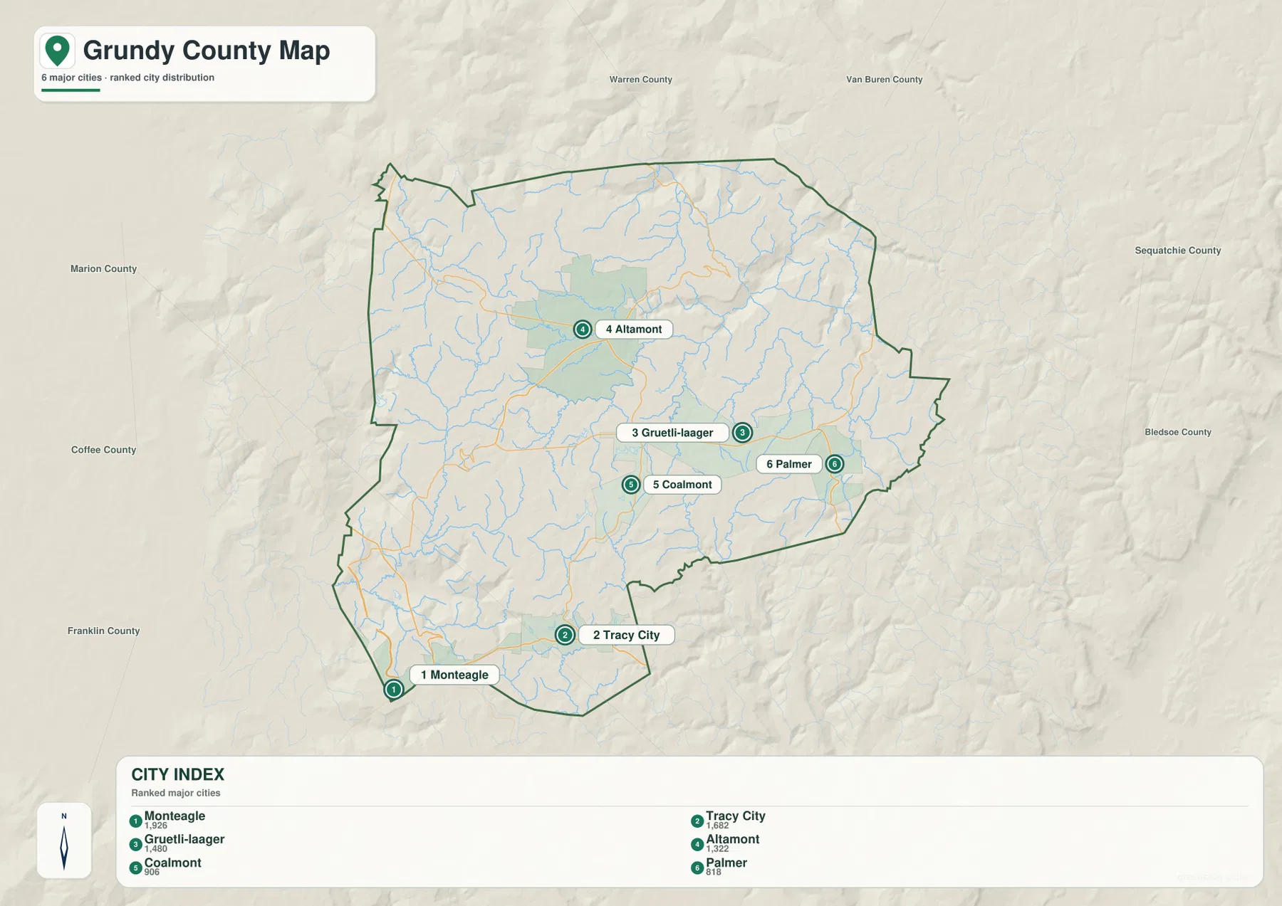
Warren and Van Buren counties appear to the north, Sequatchie and Bledsoe counties to the east, Franklin and Coffee counties to the west and southwest, and Marion County along the western side. These surrounding labels help explain the irregular county outline. Monteagle provides a useful reference toward the Franklin–Marion side, while Palmer marks the direction toward Sequatchie County.
Routes 50, 108, and 56 cross the plateau, while I-24 touches the Monteagle side
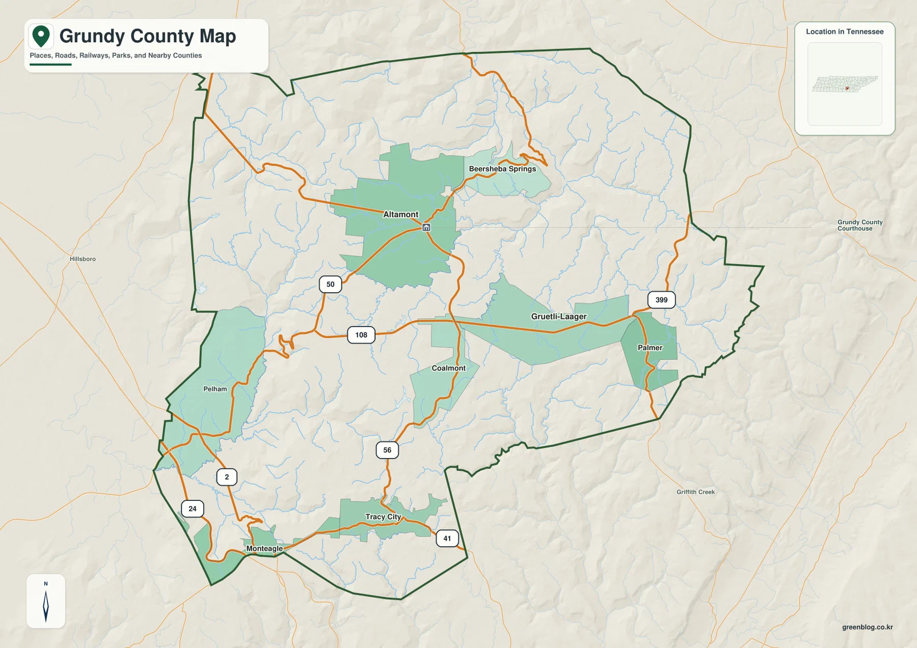
Route 50 is a clear reference west of Altamont and helps establish the north-central road pattern. Route 108 approaches from the Pelham side and continues eastward toward the Gruetli-Laager area, while Route 56 runs south from Altamont toward Coalmont and Tracy City. These three roads are enough to sketch the main internal connections before the smaller routes are added.
Route 399 is prominent around Gruetli-Laager and Palmer in the east, and Route 41 appears near Tracy City in the southeast. Around Monteagle, I-24 and Route 2 provide a much larger outside connection at the southwestern edge of the county. That makes the Monteagle area different from the interior plateau towns: it sits where local county roads meet a major interstate corridor.
Pelham is useful for seeing how road placement responds to terrain. The elevation map shows a broad low valley in the southwest around Pelham, followed by a strong rise toward the plateau near Monteagle. Roads through this part of the county therefore follow valley floors and easier gaps rather than crossing the terrain in simple straight lines. Comparing Route 108 and the Monteagle connections with the elevation image makes that relationship clear.
Collins River and Elk River drain opposite sides of the high ground
Collins River is the strongest named water feature in the northern part of the water map. It occupies a lower valley close to the north-central boundary, while Hickory Creek cuts through the northwest. Laurel Creek runs down the western interior. On the elevation map, each of these channels lines up with green lower ground that reaches into the higher plateau surface.
The central drainage is more fragmented. Big Creek runs through the interior, with Carol Lake, Ranger Creek, and Big Creek Lake nearby. Ramsey Lake lies farther south. These features show that the plateau is not one continuous flat block; small lakes and tributaries occupy numerous shallow-to-deep cuts across the interior.
In the southwest, Elk River is the boldest water line, with Patton Pond and Goose Pond nearby. Dr Littell Lake and Hines Pond sit farther south, while Mill Creek follows a pronounced valley near the eastern side. A simple way to read the water layer is to begin with Collins River in the north, Elk River in the southwest, Big Creek in the center, and Mill Creek in the east, then add the smaller lakes and tributaries only when they are relevant.
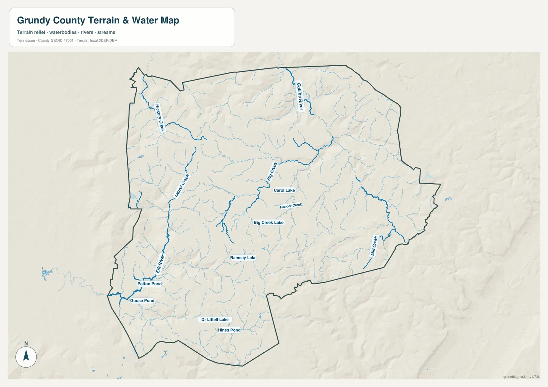
This water layer is intended for geographic reference, not current water conditions. It does not establish flood limits, safe crossings, navigable channels, or property boundaries. Its main value here is showing how stream valleys divide the plateau and how towns and roads sit in relation to those lower corridors.
A 268–727 m range reveals a high plateau cut by deep valleys
The elevation map shows an actual range of about 268 to 727 meters, with a mean near 528 meters. Tan and brown colors cover much of the central and eastern county, representing broad high ground. Deep green valleys enter from the north and southwest, and darker brown ridges appear along parts of the eastern and southeastern edge. The height difference is large enough that the terrain changes noticeably over relatively short distances.
The north is strongly dissected around Collins River and its tributaries. Low green branches reach far into the plateau, leaving higher ridges between them. Altamont and Beersheba Springs sit within this elevated interior rather than on a single flat tabletop, and the surrounding creeks repeatedly cut the high surface into smaller blocks.
The southwest provides the strongest lowland contrast. Pelham lies in a broad green valley, while the terrain climbs again toward Monteagle and Tracy City. In the east, higher ridges stand out near the Palmer side, with Mill Creek occupying a lower corridor between them. Grundy County is therefore best understood as a high plateau broken by deep drainage valleys, not as a uniformly level upland.
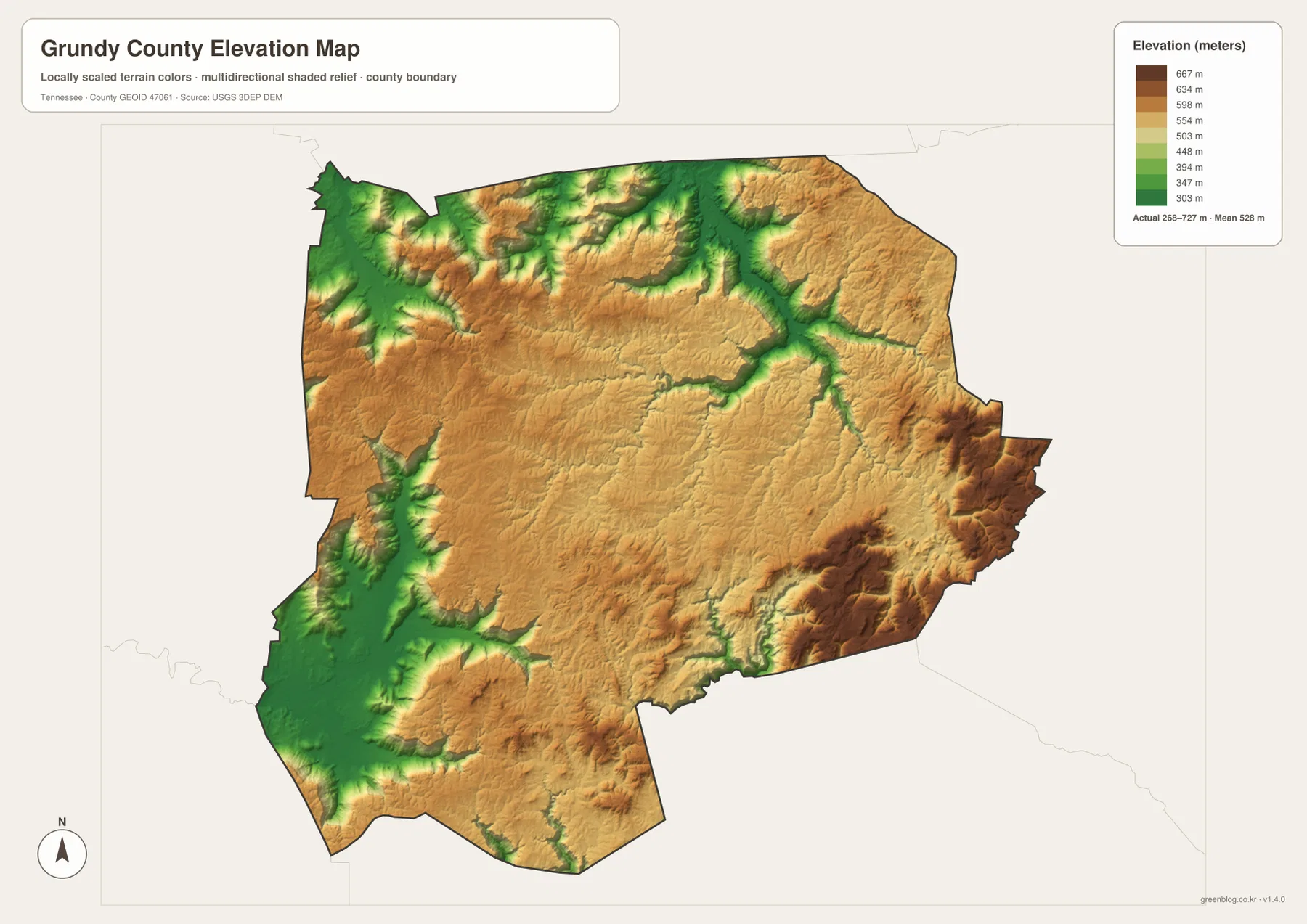
The terrain colors are designed for relative comparison across the county. They are not a survey-grade elevation for a specific property, but they clearly show why roads use valleys and gaps and why the northern and southwestern drainage corridors look so different from the plateau around Altamont, Gruetli-Laager, and Tracy City.
From Altamont to Pelham, the road and water maps explain the terrain
The city map first establishes the separation between the southern Monteagle–Tracy City group, central Altamont, and the eastern Gruetli-Laager–Palmer side. The base map adds Routes 50, 108, 56, and 399. The water layer then shows that Collins River and Elk River occupy very different low valleys, while the elevation map explains why those valleys cut so deeply into an otherwise high county.
Altamont, Gruetli-Laager, and much of the Tracy City area sit on generally high ground. Pelham and the Elk River side drop much lower, while the Collins River system creates another low network in the north. Monteagle is close to the southwestern edge but sits higher than the Pelham valley, so two nearby southern references can have very different terrain around them.
Choose the map according to the question. The city map is the cleanest for comparing the six ranked places, while the county map is better for roads and boundaries. Use the water map for Collins River, Elk River, Big Creek, and the named lakes, and use the elevation map when the plateau-versus-valley contrast is the main subject.
Choosing and downloading the A3 JPG maps
The WebP images in the article are convenient for quick viewing, while the JPG originals in the ZIP are better for printing, enlargement, and offline reference. For a road-focused page, mark Altamont and only the destination town and route needed on the county map. Use the city map separately when city rank and location are more important than the local road network.
For water-focused work, start with Collins River, Elk River, and Big Creek before adding smaller lakes or tributaries. The elevation map is especially useful in color because the high plateau and deep valleys are separated by strong terrain shading. A3 output also provides more room for creek names, small lakes, and route numbers than the browser preview.
The downloadable ZIP contains the high-resolution A3 JPG originals for the county, city, water, and elevation maps shown on this page. They can be used for classroom comparison, presentations, route notes, regional study, or personal offline storage when a larger image is more useful than the web preview.
Frequently Asked Questions
Why is Altamont the county seat if Monteagle is larger on the city map?
The city map ranks Monteagle at 1,926 residents and Altamont at 1,322. Altamont is the county seat and administrative center, while Monteagle is the larger ranked city on this map. Population size and county-seat status describe different roles.
Where is the strongest elevation contrast in Grundy County?
The map shows roughly 268–727 meters of elevation. Broad high ground covers much of the center and east, while Collins River valleys in the north and the Pelham–Elk River side in the southwest drop much lower. Higher ridges also stand out along parts of the eastern edge.
Sources and reference data
County boundaries and general location can be compared with U.S. Census Bureau TIGER/Line. Local county history and reference material are available from the Tennessee State Library and Archives Grundy County fact sheet, and the Tracy City road pattern can be compared with the Tennessee Department of Transportation Tracy City map.
For broader hydrography reference, see USGS National Hydrography. Elevation data can be compared with the USGS 3D Elevation Program. The descriptions on this page are based on the towns, roads, water features, and elevation patterns visible in the supplied Grundy County maps.
Map File Information
Download the high-resolution A3 JPG originals for the Grundy County county, city, water, and elevation maps shown in this article.
- Included Files: County map, city map, water map, elevation map
- File Type: ZIP containing 4 JPG files
Related Maps
Green Map creates custom-edited map images using open geographic data sources such as geoBoundaries, Natural Earth, OpenStreetMap, and government open data. These maps are edited visual materials, not raw data files, and are provided for education, documents, presentations, and graphic reference.