You can download the Scott County Tennessee Map files on this page as one ZIP containing high-resolution JPG versions of the county, city, water, and elevation maps. Oneida and Huntsville provide two different reference points: Oneida is the largest ranked city on the city sheet, while Huntsville is the county seat. The maps also show US 27, several state routes, the New River and Clear Fork valleys, and a large elevation range from about 243 to 989 meters. The files are suitable for A3 printing, presentations, classroom work, and general county reference.
Scott County is a strongly dissected part of northern Tennessee where roads and communities occupy long valleys between higher plateau ridges. Oneida and Winfield sit close together in the north-central area, Huntsville lies farther south, and Helenwood, Robbins, and Elgin continue the settlement pattern toward the southwest. The county becomes much more rugged toward the east and south, so the road, water, and elevation sheets explain one another particularly well here.
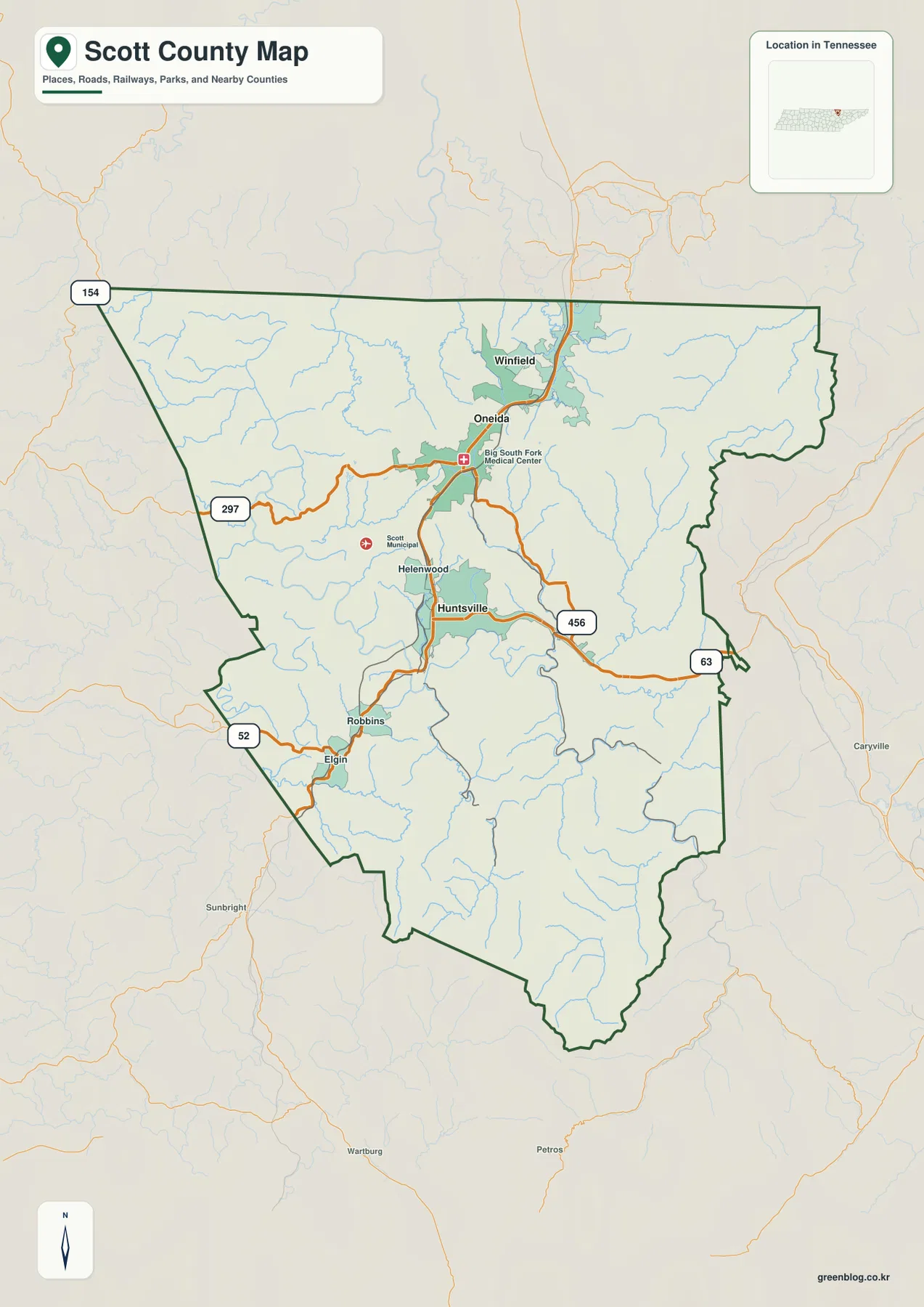
Table of Contents
US 27 links the county’s main settlement chain
The most useful road reference is US 27, which runs through the north-central and southwestern settlement corridor. Winfield and Oneida appear near the northern part of that line, followed by Huntsville, Helenwood, Robbins, and Elgin farther south. Because several communities share the same broad corridor, US 27 is a better first orientation feature than trying to memorize every smaller road separately.
State routes then show how travel spreads away from the main corridor. SR 297 curves west from the Oneida area through rolling terrain, while SR 456 runs east from Huntsville toward the county’s rugged eastern side. SR 52 appears in the southwest around Robbins and Elgin, SR 63 reaches the eastern side, and SR 154 is marked near the northwestern edge. These routes are not laid out on a flat grid; many bends correspond to creek valleys and breaks in the surrounding ridges.
The terrain becomes especially important east and south of the main settlement corridor. Roads entering those areas have fewer broad low passages and more narrow valley approaches. Comparing the road and elevation sheets shows why a short straight-line distance may cross several ridges, while the practical route follows a creek or river valley for much longer. The reference map therefore works best for county-scale orientation rather than turn-by-turn travel.
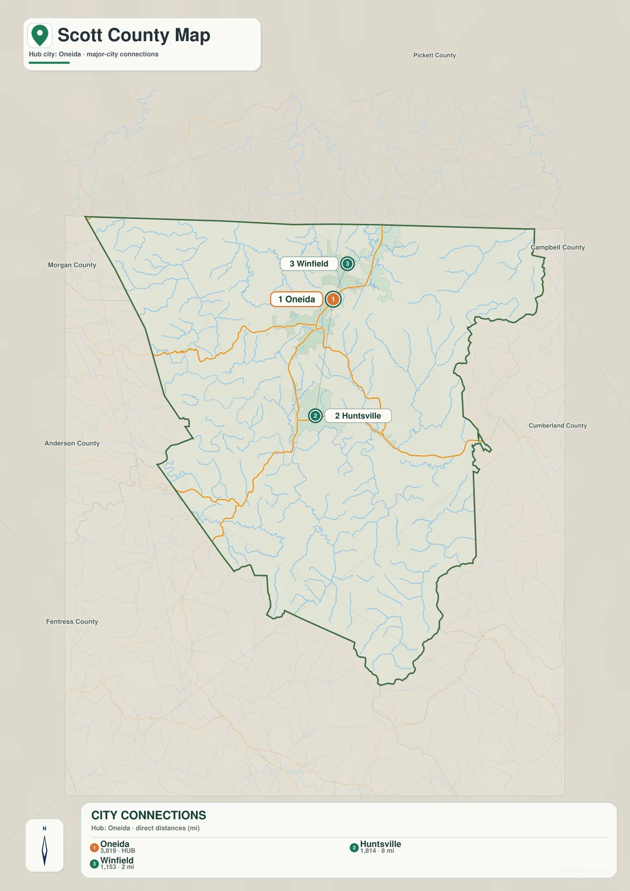
Oneida is the city-map hub, but Huntsville is the county seat
The ranked city sheet places Oneida first at 3,819, Huntsville second at 1,814, and Winfield third at 1,153. That ranking can be misleading if it is confused with county government. Huntsville is the county seat even though Oneida is the larger ranked city and the hub used for the city-connections graphic. The distinction is useful because it separates administrative location from population and travel prominence.
Oneida and Winfield sit close together in the northern half, while Huntsville is farther south along the same general county corridor. Helenwood helps fill the space between the major labels, and Robbins and Elgin extend the chain toward the southwest. Rather than forming one continuous urban area, these places are separated by wooded hills, creeks, and narrow transportation corridors.
The surrounding-county labels add another layer of orientation. Campbell, Anderson, Morgan, Fentress, and Pickett counties appear around the Tennessee sides, with McCreary and Wayne counties on the Kentucky side of the regional boundary. Roads and waterways continue beyond the county outline, so the thick county line matters most when a place or route approaches the edge.
New River and Clear Fork occupy very different valleys
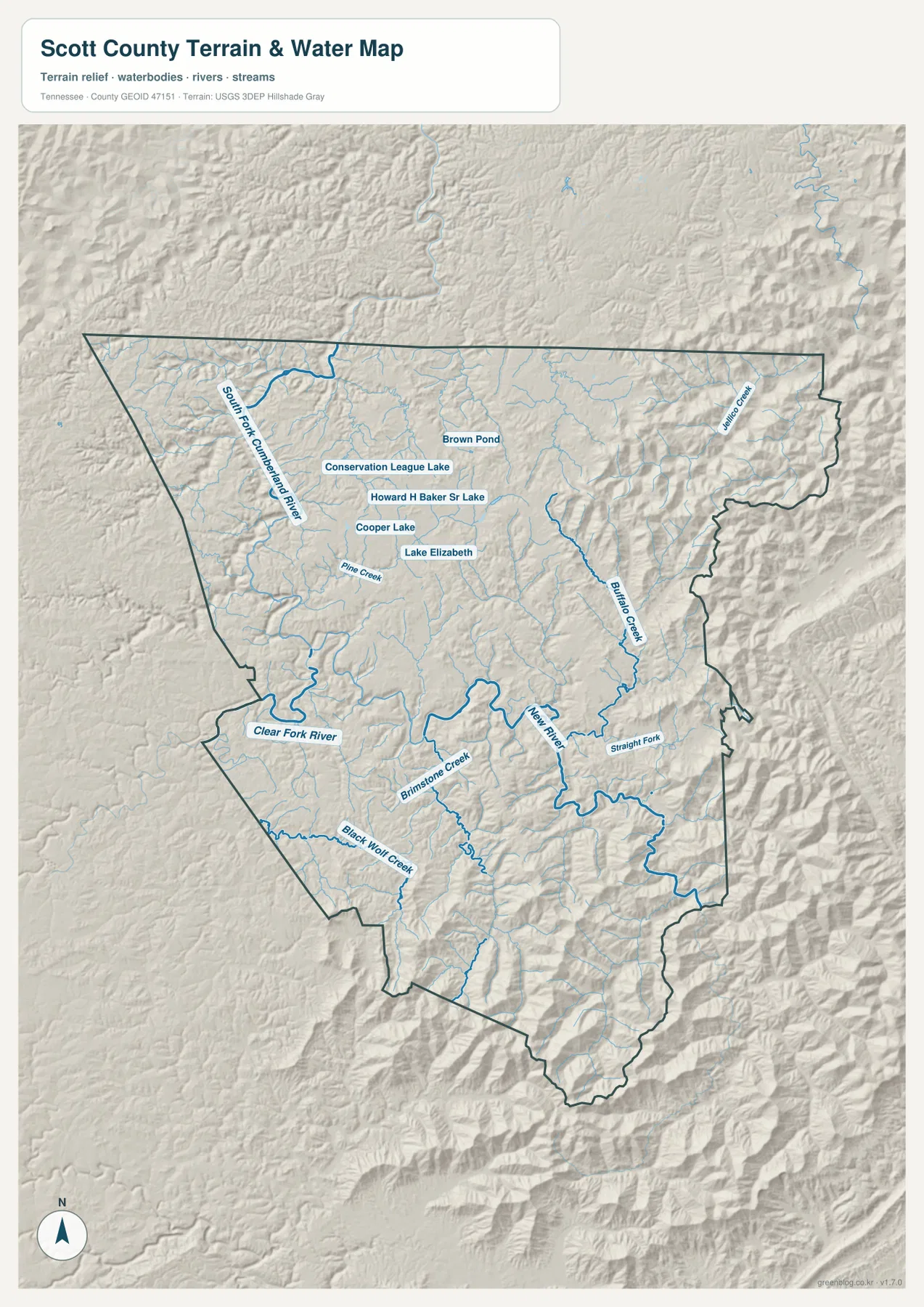
New River is one of the most prominent water features in the southeastern half of the county. It makes a series of broad bends through a mountain valley, with Buffalo Creek and Straight Fork entering the same rugged part of the map. Brimstone Creek runs through the south-central interior, and Black Wolf Creek provides another long drainage reference farther southwest.
Clear Fork River follows lower terrain near the western and southwestern side, while South Fork Cumberland River is labeled in the northwest. Pine Creek and numerous shorter tributaries descend from the surrounding hills. Juggs Creek appears near the northeastern edge, reinforcing the fact that the eastern boundary is not a smooth plateau surface but a deeply cut sequence of ridges and drainage valleys.
A cluster of smaller named waters appears in the north-central area, including Brown Pond, Conservation League Lake, Howard H Baker Sr Lake, Cooper Lake, and Lake Elizabeth. These water bodies are much smaller than the major rivers, but they are useful landmarks around the Oneida side of the county. The water sheet is a location and terrain reference, not a source for live water levels, flood warnings, or boating conditions.
Relief rises from about 243 meters to nearly 1,000 meters
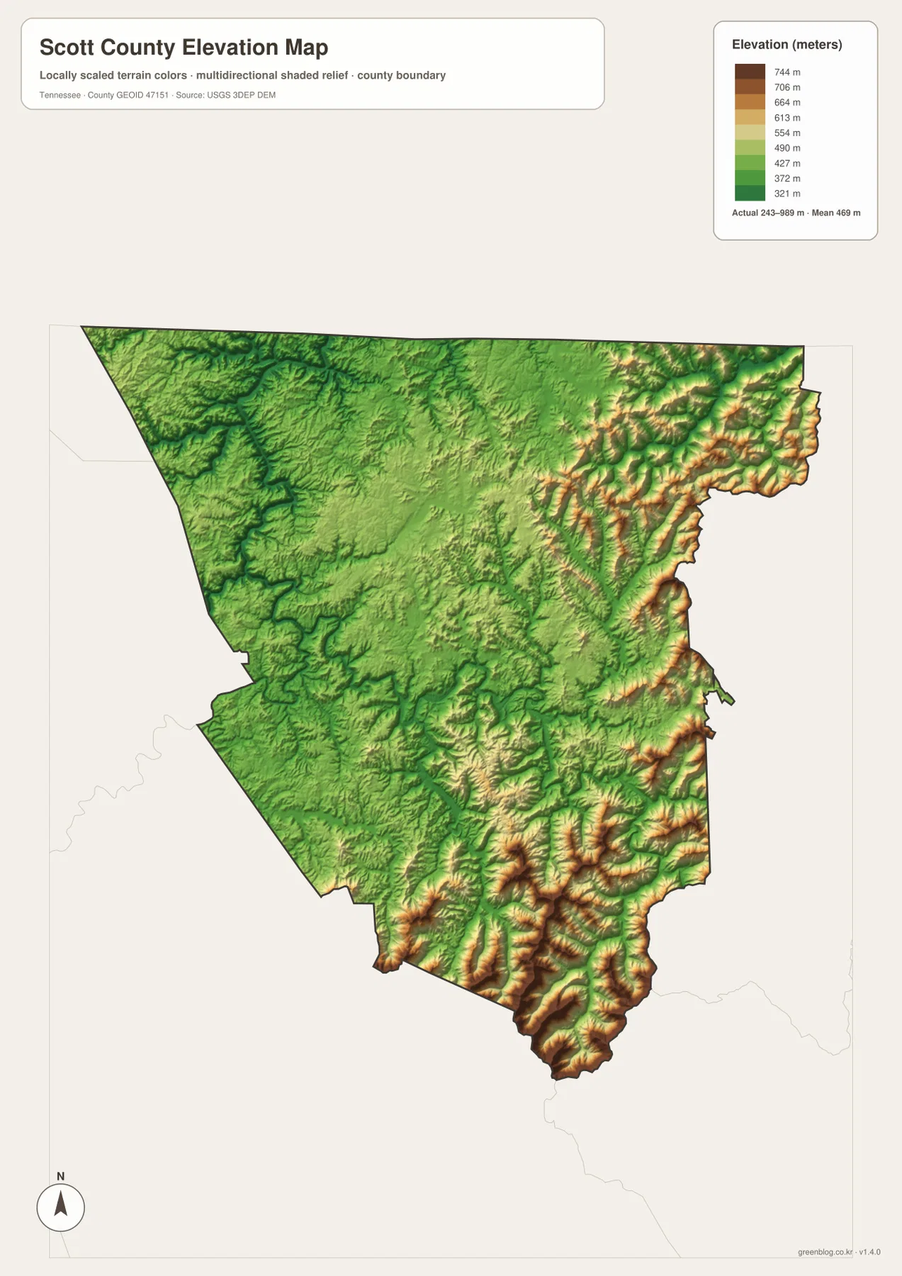
The supplied elevation map lists an actual range of about 243 to 989 meters, with a mean near 469 meters. Lower dark-green terrain is most widespread in the west and northwest, while the central county is dominated by moderate green relief. Higher yellow, tan, and brown ridges become much more common toward the east and south, with some of the strongest relief concentrated along the southeastern and eastern margins.
The New River valley cuts a low, winding path through the high eastern terrain. Buffalo Creek and other tributaries occupy similarly narrow corridors, and the southern part of the county contains repeated ridge-and-valley forms around Brimstone Creek and neighboring drainages. The Clear Fork side is generally lower and broader, which gives the western half a noticeably different appearance from the rugged east.
Oneida, Winfield, and Huntsville occupy lower or middle-elevation corridors compared with the tallest eastern ridges. That helps explain why the main settlement and highway line is relatively continuous while the eastern side has fewer large population labels. The elevation map is intended for comparing county-scale relief and valley position, not for survey-grade elevation or exact property slope.
County facts that add context to the maps
- Official name: Scott County, Tennessee
- County seat: Huntsville
- FIPS code: 47151
- Established: 1849
- 2020 Census population: 22,039
- July 2025 population estimate: 22,671
- 2025 Gazetteer area: 532.3 square miles of land and 0.9 square miles of water
- Elevation shown on this map: about 243–989 m, mean about 469 m
The 22,039 figure is the completed 2020 Census count, while 22,671 is a July 2025 estimate. They are different types of population measures and should remain labeled separately. The county’s 532.3 square miles of land cover a large landscape that includes the Oneida and Huntsville settlement corridor as well as extensive wooded ridges and river valleys.
The Tennessee State Library and Archives material supplied with the package identifies Scott County as established in 1849 and Huntsville as the county seat. The city sheet adds a useful modern contrast by showing Oneida as the largest ranked city. Together, those facts explain why a map reader should not assume that the most populous mapped town and the administrative seat must be the same place.
Choose the map by the feature you need to find
Start with the county reference map when you need Oneida, Huntsville, Winfield, Helenwood, Robbins, Elgin, US 27, and the major state routes on one page. It is the best view for understanding the county’s main settlement corridor and the roads that leave it. The city sheet is cleaner when the question is how Oneida, Huntsville, and Winfield compare or why the city hub differs from the county seat.
Use the water map for New River, Clear Fork River, South Fork Cumberland River, Buffalo Creek, Brimstone Creek, and the cluster of small lakes near the north-central area. The elevation sheet then shows why those streams occupy deep green valleys and why the east and south are so rugged. Viewing water and relief together gives the clearest picture of the county’s valley network.
The downloadable ZIP contains high-resolution JPG versions of all four maps and can be printed at A3 size while preserving the original proportions. Keep an untouched original if you plan to add arrows, route lines, or notes to a working copy. These are static reference maps, so current road closures, flood warnings, trail access, legal parcel boundaries, and emergency conditions should be checked with the responsible agency.
Frequently Asked Questions
Why is Oneida the city-map hub if Huntsville is the county seat?
The city sheet uses Oneida as the hub because it is the largest ranked city on that map, at 3,819. Huntsville is the county seat and has a different administrative role. Use Oneida when comparing city positions and Huntsville when locating county government.
Where are New River and Clear Fork River on the map?
New River winds through the southeastern and eastern mountain terrain, while Clear Fork River is closer to the lower western and southwestern side. The elevation map makes the contrast especially clear because New River is enclosed by much higher ridges.
Which part of Scott County is highest?
The strongest high relief appears in the east and south, particularly near the southeastern and eastern boundary. The displayed elevation range is about 243 to 989 meters, with a mean near 469 meters. Western river valleys are generally much lower.
Map File Information
The ZIP contains high-resolution JPG versions of the county, city, water, and elevation maps. They are suitable for A3 printing, presentations, classroom material, and general location reference.
- Included Files: county, city, water, and elevation JPGs
- File Type: JPG files in one ZIP
Related Maps
- Alamo to Gadsden: A Crockett County Tennessee Map
- Altamont, Monteagle, and Plateau Valleys — Grundy County Tennessee Map
- Around Chattanooga: Hamilton County Tennessee Map
Sources and references
- Tennessee State Library and Archives — Scott County fact sheet
- Tennessee Department of Transportation — Scott County road reference
- U.S. Census Bureau QuickFacts — Scott County, Tennessee
- U.S. Census Bureau TIGER/Line boundary data
- USGS National Hydrography
- USGS 3D Elevation Program
Green Map creates custom-edited map images using open geographic data sources such as geoBoundaries, Natural Earth, OpenStreetMap, and government open data. These maps are edited visual materials, not raw data files, and are provided for education, documents, presentations, and graphic reference.