Download the Canyon County Map as one ZIP containing high-resolution A3 JPG versions of the county overview, city, terrain-and-water, and elevation maps. The WEBP previews below let you inspect Nampa, Caldwell, the Boise and Snake rivers, Lake Lowell, major roads, and local relief before opening the larger files for printing, classroom work, reports, or presentations.
Canyon County occupies the western side of Idaho’s Treasure Valley, where a large urban area around Nampa and Caldwell meets river lowlands, irrigated country, and scattered higher ground. The Boise River crosses the county from east to west, the Snake River follows much of the western and southwestern edge, and Lake Lowell forms a major water landmark south of the central cities. Those features make the county easy to recognize once the four map views are compared.
Table of Contents
Nampa and Caldwell anchor the eastern half of the county
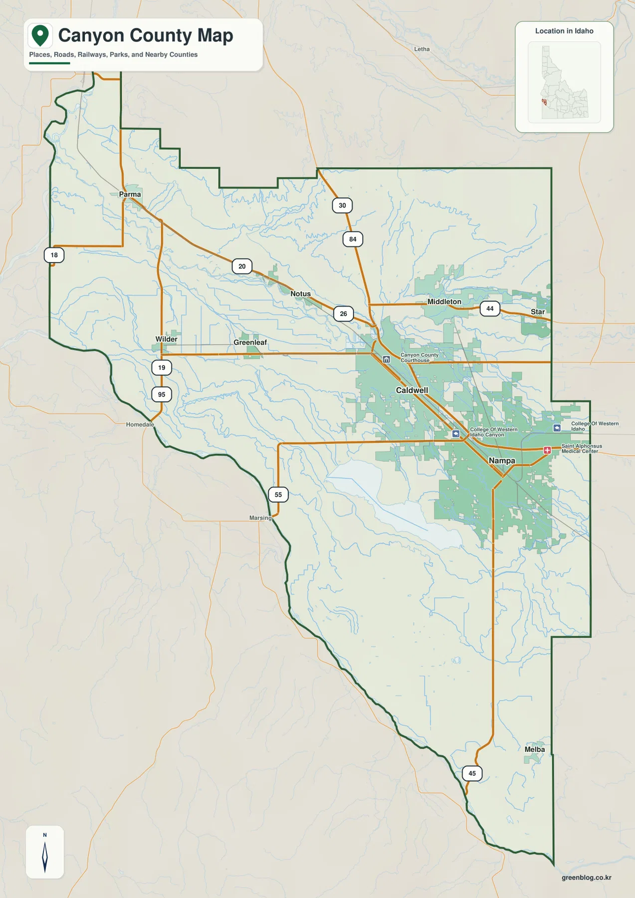
The county overview places Nampa and Caldwell close together in the eastern half of Canyon County, where the road network is much denser than it is farther west. The Canyon County Courthouse is marked in Caldwell, providing a useful administrative landmark. Middleton lies to the northeast, Notus sits northwest of Caldwell, and Greenleaf and Wilder extend the chain of communities westward toward Parma.
The county outline is irregular. A narrow northern section reaches toward Parma, the eastern edge steps around the Middleton and Nampa side, and the southern portion stretches down toward Melba. Along much of the west and southwest, the boundary closely follows the Snake River corridor. Reading the border and the river together makes the county’s long north-south shape easier to remember.
The city ranking shows a strong Nampa–Caldwell center
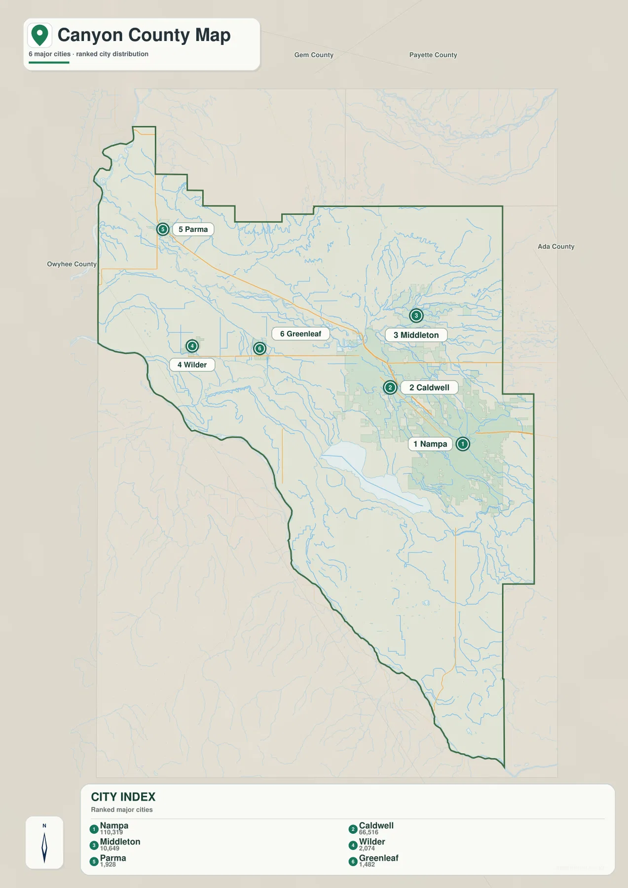
The city map highlights six places: Nampa, Caldwell, Middleton, Wilder, Parma, and Greenleaf. Nampa ranks first in the supplied city index and Caldwell ranks second, and both are far larger than the remaining communities. Middleton is third and sits to the northeast, while Wilder, Parma, and Greenleaf form smaller western and northwestern centers.
This pattern is useful for understanding the county before studying individual roads. Nampa and Caldwell define the main urban core, Middleton extends the developed area toward the northeast, and the western towns sit closer to the Boise and Snake river lowlands. The city map removes much of the background detail, so the relative directions among these communities are easier to see than on the full overview.
Route 84 and the 20, 26, 95, 55, and 44 corridors
The overview shows the 84 corridor running through the Nampa–Caldwell area, giving the eastern side a clear transportation spine. Roads 20 and 26 cross the central section around Notus and Caldwell, while 30 appears north of Caldwell. In the west, 95 runs north-south between the Parma and Wilder areas, and 19 provides an east-west link through Wilder, Greenleaf, and Caldwell.
Other numbered roads help define the county’s edges. Route 55 heads southwest toward the Marsing side, 45 reaches south toward Melba, and 44 runs east-west through Middleton. Looking at these roads together explains why the largest cities are concentrated in the eastern half while the western and southern parts contain longer rural connections between smaller communities.
Boise River, Snake River, Lake Lowell, and a dense canal network
The terrain-and-water map is centered on two major rivers. The Boise River crosses the middle of Canyon County from east to west, while the Snake River follows much of the western and southwestern boundary. Sand Hollow Creek approaches the Snake River in the northwest, and Willow Creek enters the Boise River system from the northeast. These natural channels give the lower part of the county a clear drainage framework.
Lake Lowell is the most prominent inland water body on the map and lies south of the main Nampa–Caldwell area. Several named canals also cross the county, including Deer Flat Low Line Canal, Phyllis Canal, Wilson Canal, and Notus Canal. Mason Creek, Indian Creek, and Tenmile Creek add more smaller channels around the urban and agricultural areas.
Canyon County’s official Lake Lowell Park page identifies the lake as an important local water and recreation area. The map on this page, however, is only a geographic reference for rivers, lakes, creeks, and canals. It should not be used as a flood map, depth chart, navigation chart, parcel boundary, or legal water-right document.

Elevation is lowest along the river corridors and higher on scattered ridges
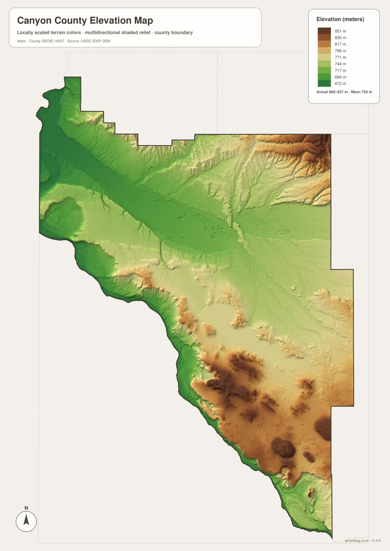
The elevation map shows broad dark-green lowlands in the northwest and through much of the Boise River and Snake River corridors. Around the Nampa–Caldwell plain, the terrain remains relatively gentle. Higher colors become more common along the northeastern edge and across parts of the south and southeast, where isolated ridges and hills rise above the surrounding low country.
The supplied elevation map reports an actual range of about 660 to 937 meters, with a mean near 755 meters. The strongest brown tones occur on the higher northeastern ridge and on several southern uplands, while the river valleys remain greener. This generalized surface is useful for county-scale comparison, but it is not survey-grade or engineering-grade elevation for a particular property or construction site.
Using the four views together clarifies the county’s east–west contrast
For general orientation, the county overview and city map are the fastest starting points. They show where Nampa and Caldwell dominate the eastern half and how Middleton, Wilder, Parma, and Greenleaf relate to the main road network. When the goal is to understand the western lowlands or Lake Lowell, the water map adds the Boise River, Snake River, canals, and smaller streams that are not as obvious on the city view.
The elevation map completes the picture by showing why some areas look flatter and more open than others. A place such as Caldwell can be located first on the city map, then compared with the Boise River on the water map and the surrounding low relief on the elevation map. This approach works well for classrooms, reports, trip planning, presentations, and county-to-county geographic comparisons.
Frequently Asked Questions
Where are Nampa and Caldwell on the Canyon County map?
They are close together in the eastern half of the county. Nampa lies to the southeast of Caldwell, and the 84 corridor and several other major roads pass through or near both cities.
Which map is best for finding Lake Lowell?
The terrain-and-water map is the clearest view. Lake Lowell appears as a large water body southwest of Nampa, with several canals and smaller channels around it. The county overview also shows its general position.
Which parts of Canyon County are higher in elevation?
The northeastern edge and several southern and southeastern uplands are higher than the broad river lowlands. The Boise River and Snake River corridors are among the lower areas on the supplied elevation map.
Map File Information
The ZIP contains high-resolution A3 JPG versions of the Canyon County overview, city, terrain-and-water, and elevation maps.
- File Type: JPG files inside one ZIP archive
Related Maps
Sources and references
- Canyon County official website — About
- Canyon County — Lake Lowell Park
- U.S. Census Bureau TIGER/Line Shapefiles
- USGS National Hydrography
- USGS 3D Elevation Program
Green Map creates custom-edited map images using open geographic data sources such as geoBoundaries, Natural Earth, OpenStreetMap, and government open data.
These maps are edited visual materials, not raw data files, and are provided for education, documents, presentations, and graphic reference.