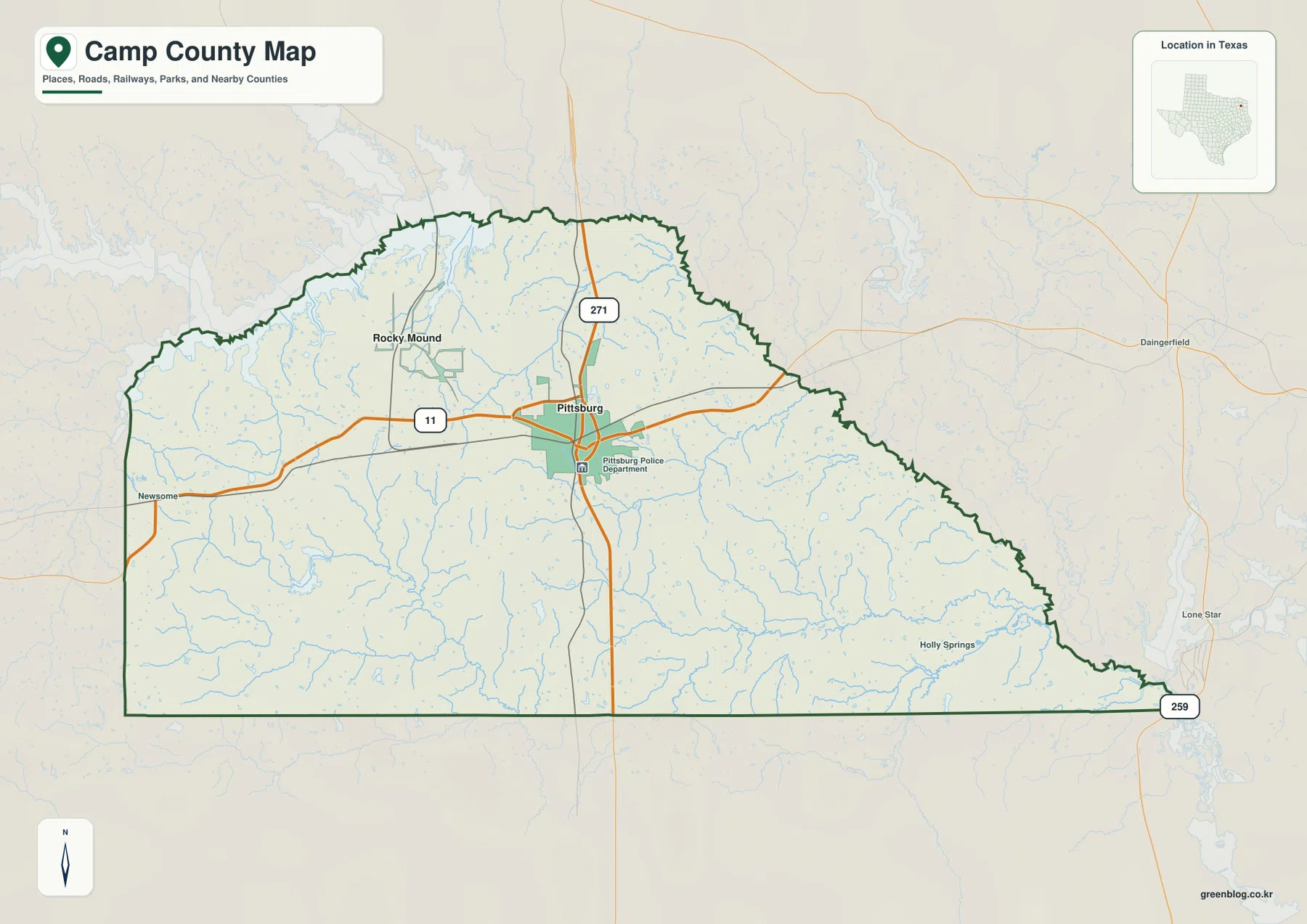
Camp County is a compact county in Northeast Texas, but its maps show a clear contrast between the road-centered area around Pittsburg and the creek-cut countryside extending toward the county edges. This page brings together the county boundary and road map, ranked city map, terrain-and-water map, and elevation map. A ZIP containing the four matching high-resolution JPG files is also available for download, so the maps can be enlarged or printed when the web previews are too small for local labels.
A useful way to begin is to locate Pittsburg where US 271 meets Highway 11, then work outward to Rocky Mound, Newsome, and Holly Springs. After that, compare the named creeks with the elevation surface. Wilkins Creek, Dry Creek, Prairie Creek, and several smaller branches cross a landscape that is generally higher in the west and lower toward the east, making the four maps more informative when read together rather than as isolated graphics.
Table of Contents
Pittsburg as the Road and Settlement Reference Point
The general county map places Pittsburg near the upper-central part of Camp County. US 271 runs north and south through the city, while Highway 11 crosses from west to east. Their meeting point makes Pittsburg the easiest reference for orienting the rest of the county. Rocky Mound lies to the northwest, Newsome appears near the western boundary, and Holly Springs is farther southeast where the road network is noticeably thinner.
The boundary itself changes character around the county. The western and southern edges include long straight segments, while the northern and eastern sides are more irregular. Outside the eastern side, Daingerfield and Lone Star appear as useful regional references, and route 259 is marked near the narrow southeastern end. The map therefore shows both the administrative outline and the directions in which local roads continue toward nearby parts of Northeast Texas.
Pittsburg also stands out because the built-up area is more concentrated around it than elsewhere on the map. Following US 271 or Highway 11 away from the city, the pattern quickly shifts to smaller roads, scattered communities, and numerous stream crossings. That change is one of the most useful county-specific details on the map: Camp County is small enough that the main center and the rural edge can be compared within a single view.
What the Ranked City Map Shows About Pittsburg and Rocky Mound
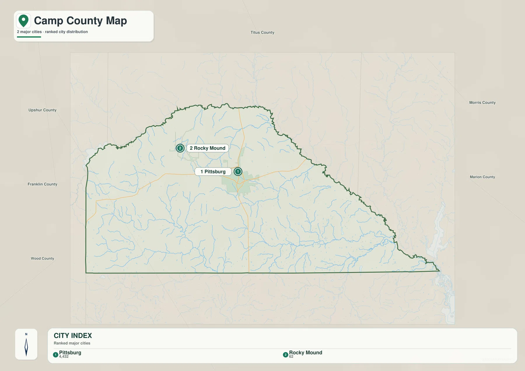
The city map intentionally simplifies the county by ranking only two major places. Its index labels Pittsburg at 4,432 and Rocky Mound at 62, so the scale difference is immediately visible. More important than the numbers alone is their placement: Pittsburg sits close to the road-centered core, while Rocky Mound is northwest of it in a more rural setting crossed by smaller streams and local roads.
The surrounding county labels help explain why this small county is closely tied to its neighbors. Titus County lies to the north, Morris County to the northeast, Marion County to the east, Upshur County to the west, Franklin County farther west and northwest, and Wood County to the southwest. Because these boundaries are not far from Pittsburg, regional orientation is easier when Camp County is viewed as part of a cluster of Northeast Texas counties rather than as an isolated shape.
Rocky Mound is much smaller than Pittsburg on the ranked map, yet it remains useful for locating the northwestern portion of the county. It marks a part of Camp County where the urban footprint is minimal and where the boundary, creeks, and rolling ground become more visually important than streets. Pittsburg, by contrast, is the clearest reference for comparing the city layer with the road, water, and elevation layers.
A Dense Network of Named Creeks and Small Lakes
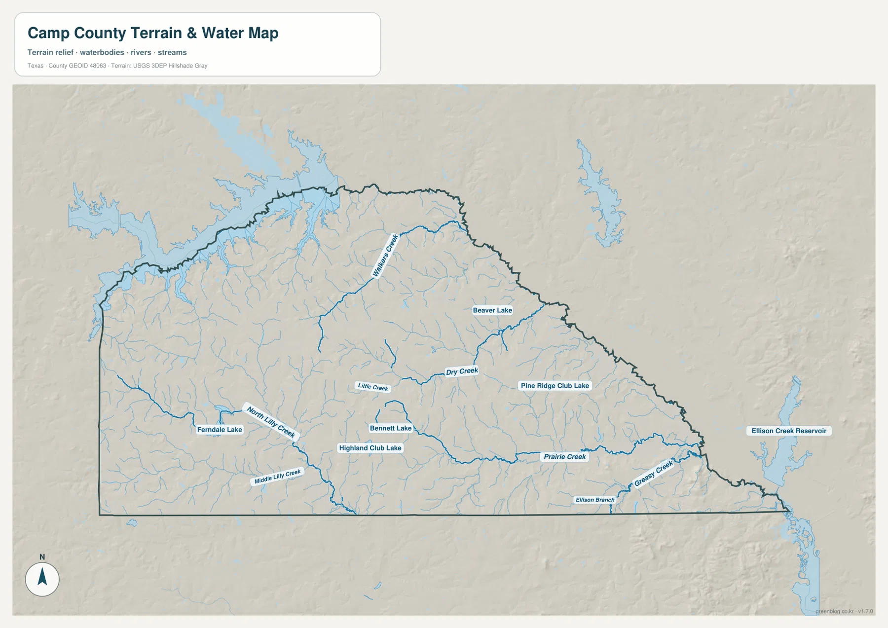
The terrain-and-water map reveals a much more intricate county than the road map alone suggests. Wilkins Creek is prominent in the north-central area, while Dry Creek and Little Creek occupy the middle of the county. North Lilly Creek and Middle Lilly Creek appear farther south and west. To the east, Prairie Creek and Greasy Creek become important references, with Ellison Branch extending along the southeastern side.
Several small lakes add another layer of detail. Ferndale Lake is marked in the southwest, Bennett Lake and Highland Club Lake sit closer to the south-central area, Pine Ridge Club Lake is farther east, and Beaver Lake appears in the northeast. Ellison Creek Reservoir is shown outside the county to the east, making it clear that the local drainage pattern does not stop at the administrative line.
The distribution of these waterways helps explain the frequent bends and crossings seen on local roads. Short tributaries split and rejoin across the county, and the shaded relief shows that many of them occupy small valleys between rolling uplands. For practical map reading, it is more useful to locate a few named features—such as Wilkins Creek, Dry Creek, and Prairie Creek—than to treat the entire water network as one undifferentiated pattern.
Camp County is commonly described within the broader Big Cypress Creek basin, but this supplied water map is most useful at the smaller scale because it names the tributaries and lakes actually drawn inside the county. It is a terrain and hydrography reference, not a flood-risk, parcel, navigation, or legal-boundary product. Anyone making decisions about flooding or property should use the appropriate official data for that purpose.
Elevation from About 70 to 164 Meters
The elevation map gives an actual mapped range of about 70 to 164 meters and a mean of roughly 109 meters. Camp County is not mountainous, yet the shaded surface shows substantial local relief. The western and northwestern portions contain more of the brown and orange higher ground, while greener, lower terrain becomes more extensive toward the east.
This west-to-east change is not perfectly uniform. Small ridges and isolated higher spots remain within the lower eastern half, and creek valleys cut through the higher western ground. That irregularity matters when the elevation map is compared with the water map: streams often occupy the lower lines between hills, so the dense drainage network makes more sense once the relief is visible.
The elevation surface is best used for county-scale comparison rather than engineering measurements. It helps show where the terrain becomes rougher, where lower valleys extend, and why roads may curve around local relief. It should not be treated as a substitute for survey-grade elevation data at a specific property or construction site.

Reading Roads, Settlements, Water, and Relief Together
The four maps become more useful when they are read in a simple sequence. Start with the county map to establish Pittsburg, US 271, Highway 11, and the county outline. Next use the city map to place Rocky Mound relative to Pittsburg and the neighboring counties. Then follow Wilkins Creek, Dry Creek, Prairie Creek, and the smaller branches on the water map before checking the elevation colors underneath those same parts of the county.
This comparison changes the way the county looks. On the road map, Pittsburg dominates the visual structure and can make the rest of the county appear fairly simple. On the water map, however, the central and southern areas are crossed by many streams, and the elevation map shows much rougher relief in the west. The settlement pattern, road geometry, and physical terrain are therefore not evenly distributed across the county.
The narrow southeastern end is another useful example. The general map places route 259 near this side of the county and shows Lone Star just beyond the boundary. The water map adds Greasy Creek and Ellison Branch, with Ellison Creek Reservoir outside the county to the east. These layers show why an administrative boundary and a natural drainage system should not be expected to follow the same shape.
Using the Maps for Printing, Classwork, and County Comparison
For a general printed reference, the county map is the most direct choice because it combines the boundary, Pittsburg, selected communities, and major roads. The ranked city map removes much of that detail and is better when the goal is to explain the contrast between Pittsburg and Rocky Mound. The water and elevation maps work particularly well as a pair when a report or classroom activity needs to show how stream valleys relate to rolling terrain.
County-to-county comparison is also straightforward because Camp County is compact and surrounded by several named neighbors. Matching it at the same scale with Titus, Morris, Upshur, Franklin, Wood, or Marion County can reveal differences in settlement spacing, boundary shape, road density, and drainage. Keeping the scale consistent is important; otherwise a small county can appear more densely developed simply because it fills more of the page.
The download below contains four high-resolution JPG files matching the county, city, water, and elevation maps shown in the article. The JPG versions are more convenient when labels need to be enlarged, a map needs to be printed, or several counties are being arranged side by side for comparison.
Frequently Asked Questions
What is the best place to locate first on a Camp County map?
Pittsburg is the clearest starting point because US 271 and Highway 11 meet there and the built-up area is easy to identify. Once Pittsburg is located, Rocky Mound, Newsome, Holly Springs, the county edges, and nearby county directions are much easier to place.
Which waterways are easiest to identify on the supplied water map?
Wilkins Creek, Dry Creek, Little Creek, Prairie Creek, and Greasy Creek are among the clearest named streams. The map also labels North and Middle Lilly Creek, Ellison Branch, and several small lakes, providing more specific local references than a broad basin name alone.
Where is the higher ground in Camp County?
The supplied elevation map shows more high ground in the west and northwest and a broader area of lower terrain toward the east. Its mapped range is about 70–164 meters with a mean near 109 meters, although small ridges and valleys create many local variations within that overall trend.
Sources and Reference Data
- U.S. Census Bureau TIGER/Line Shapefiles — official geographic boundary and transportation data.
- USGS National Hydrography — official information about streams, lakes, and hydrography data.
- USGS 3D Elevation Program — official elevation and terrain data information.
- USGS The National Map Viewer — interactive access to boundaries, hydrography, terrain, and other national map layers.
Map File Information
Download the Camp County county, city, water, and elevation maps together as high-resolution JPG files.
- Included Files: 4 maps
- File Type: JPG
Related Maps
- Morris County Texas map
- Titus County Texas map
- Upshur County Texas map
- Wood County Texas map
- Red River County Texas map
Green Map creates custom-edited map images using open geographic data sources such as geoBoundaries, Natural Earth, OpenStreetMap, and government open data.
These maps are edited visual materials, not raw data files, and are provided for education, documents, presentations, and graphic reference.