Carson County sits in the central Texas Panhandle, where long highways cross open high plains and small cities are separated by broad stretches of rural land. Panhandle is the main reference point on the county map, with White Deer to the east, Groom near Interstate 40 in the southeast, and Skellytown toward the northeast. The water map adds a very different layer: Antelope Creek, Dixon Creek, Bear Creek, White Deer Creek, and McClellan Creek cut through terrain that can look nearly flat from a road map alone. The four matching high-resolution JPG maps shown on this page are available together in a ZIP download for printing, enlargement, or side-by-side county comparison.
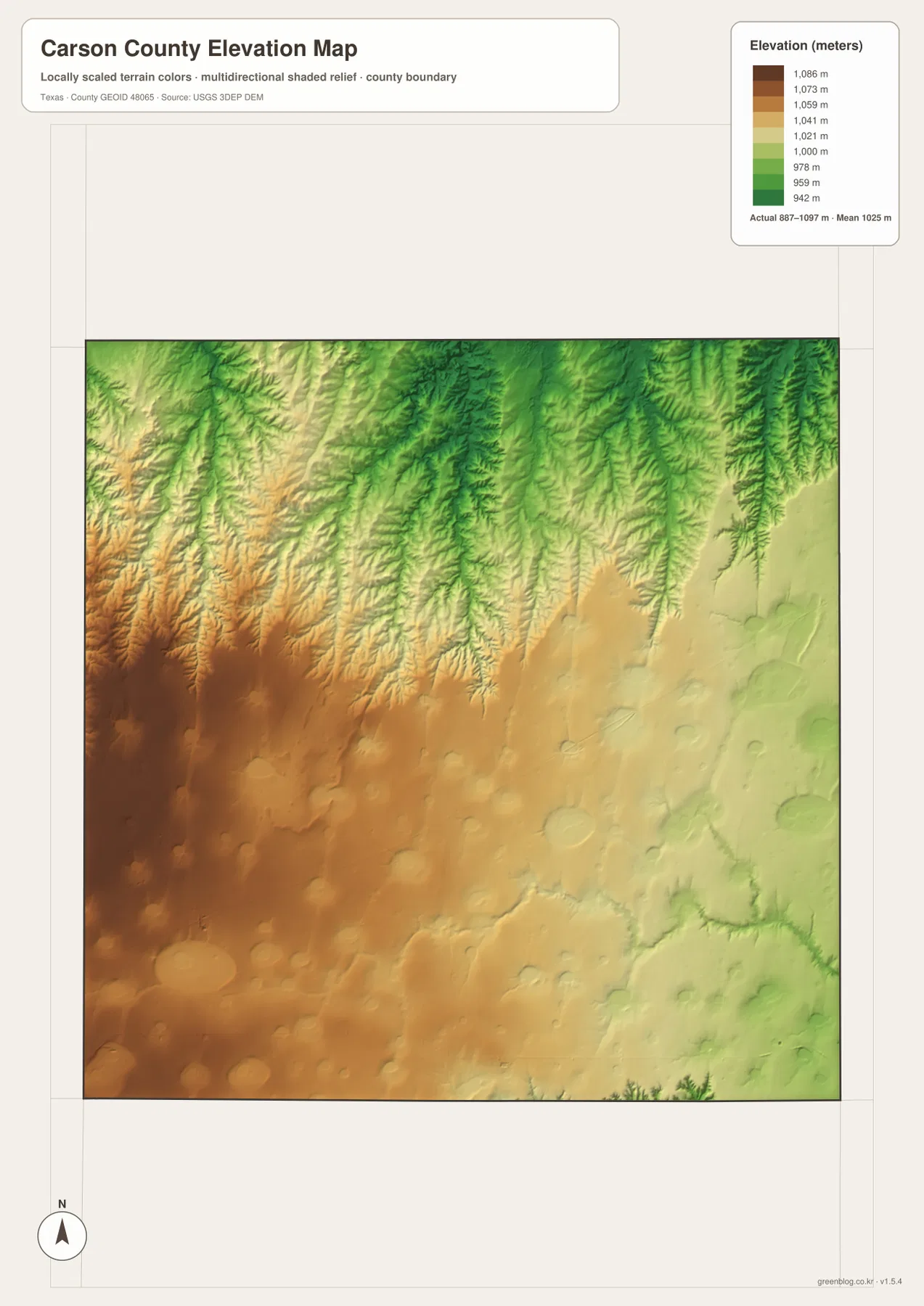
Begin with Panhandle, where Texas State Highway 207 and US 60 meet. From there, US 60 leads toward White Deer, Highway 207 runs south toward Interstate 40, and the city map shows Groom and Skellytown in different directions from the hub. The elevation map then explains why the northern half looks more deeply etched by drainage than the southwestern plain. Carson County ranges from about 887 to 1,097 meters on the supplied elevation surface, with an average near 1,025 meters, so even this high-plains county has meaningful local relief.
Table of Contents
Roads Radiating from Panhandle Across the County
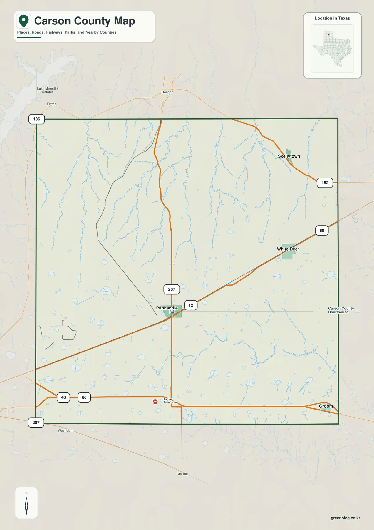
The general county map makes Panhandle the easiest place to establish orientation. Highway 207 enters from the north, passes through the city, and continues toward the southern county line. US 60 crosses Panhandle and continues east toward White Deer. The Carson County Courthouse is also marked east of the city center, reinforcing Panhandle’s role as the county seat and the clearest landmark for moving between the other map layers.
Different highways define the outer parts of the county. Interstate 40 runs across the south and passes Groom near the southeastern corner, with the historic Route 66 symbol shown nearby. US 287 follows the western side, Route 136 is marked near the northwest, and Highway 152 crosses the northeastern area near Skellytown. Borger appears beyond the northern boundary, while Claude is south of the county, so the map also gives useful reference points for travel beyond Carson County.
The open landscape makes the major roads look simple, but smaller features break up that apparent uniformity. Rail lines, local roads, scattered water bodies, and numerous creek channels appear between the cities. North of Panhandle, the landscape becomes much more dissected by drainage, while the Interstate 40 corridor across the south is straighter and more open. That contrast becomes especially clear when the road map is compared with the water and elevation maps.
How White Deer, Groom, and Skellytown Sit Around Panhandle
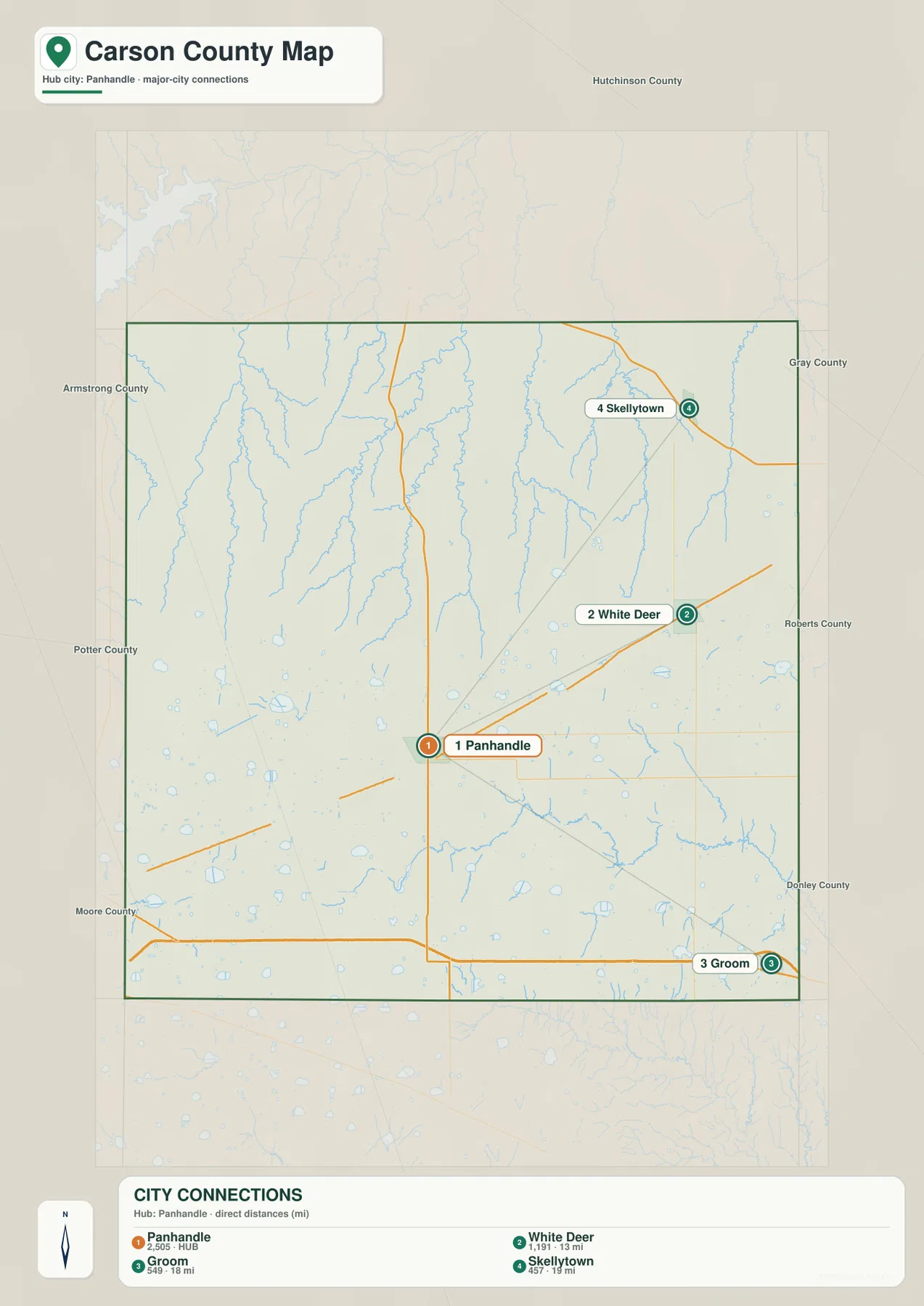
The city-connections map uses Panhandle as the hub and shows three other ranked communities. Its index lists Panhandle at 2,505, White Deer at 1,191, Groom at 549, and Skellytown at 457. The map places White Deer about 13 miles from Panhandle, Groom about 18 miles away, and Skellytown about 19 miles away. These are straight-line distances between the mapped city points, not driving distances along the highway network.
The directions matter as much as the numbers. White Deer lies east of Panhandle and aligns closely with the US 60 corridor. Groom is farther southeast near Interstate 40, while Skellytown is northeast and closer to the upper county boundary. Two cities can have similar straight-line distances from Panhandle yet require completely different road approaches, which is why the city map works best when kept beside the general road map.
Neighboring county labels provide another layer of orientation. Hutchinson County is to the north, Gray and Roberts counties are to the east, Donley County is toward the southeast, and Armstrong, Potter, and Moore counties appear along the western and southern sides of the broader view. Carson County’s communities are spread toward several different edges rather than clustered in one continuous urban strip, a pattern that fits the wide-open geography of the Texas Panhandle.
Antelope, Dixon, Bear, and White Deer Creeks Across the North
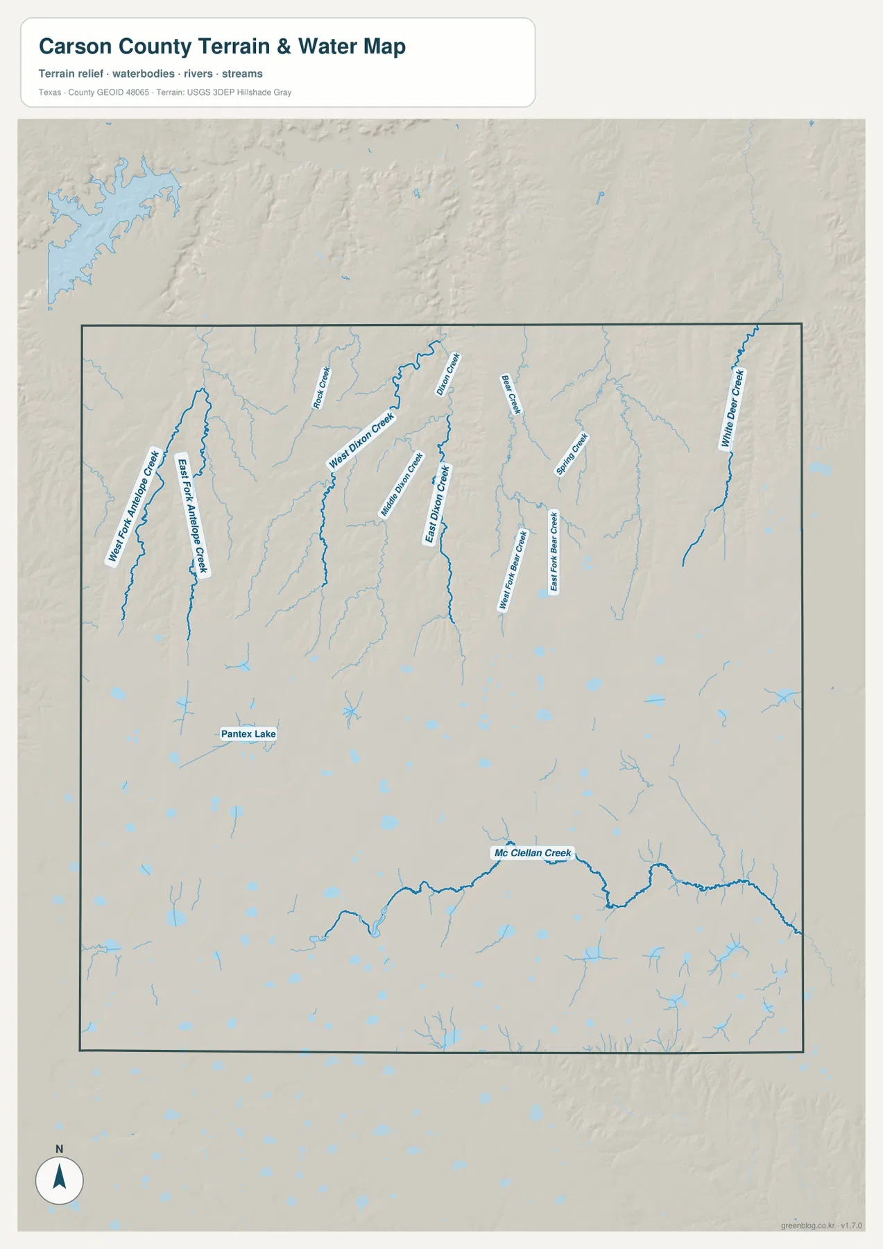
The terrain-and-water map reveals the strongest local drainage in the northern half of Carson County. West Fork Antelope Creek and East Fork Antelope Creek descend through the western side. Farther east, Rock Creek and West Dixon Creek are followed by Middle Dixon Creek, East Dixon Creek, and Dixon Creek. Big Creek and Spring Creek add more named channels near the north-central and northeastern parts of the county.
The eastern side includes West Fork Bear Creek and East Fork Bear Creek, while White Deer Creek forms one of the clearest long channels near the far eastern edge. In the southern half, McClellan Creek stands out because it runs for a long distance across otherwise more open terrain. Pantex Lake is labeled in the southwest, and numerous smaller blue water bodies are scattered across the county even where no large stream name is shown.
These waterways explain much of the texture visible on the elevation map. The northern ground is carved into branching valleys, and the named creeks tend to follow those lower lines. The southwestern high plain is broader and smoother by comparison. Reading the water and elevation maps together makes it easier to see why a county known for open plains can still contain a complicated network of shallow valleys and drainage channels.
This map is intended as a reference for the locations of streams, lakes, and terrain. It should not be used as a flood-hazard map, property-boundary map, water-quality map, or navigation chart. Those questions require the appropriate official datasets. For general geographic reading, the most useful approach is to locate a few clearly labeled features—such as Dixon Creek, White Deer Creek, and McClellan Creek—and compare their positions with nearby roads and elevation.
A High-Plain Elevation Range of About 887 to 1,097 Meters
The supplied elevation map reports an actual range of roughly 887 to 1,097 meters, with a mean elevation near 1,025 meters. Carson County is therefore high even at its lower points, but the local difference of more than 200 meters is large enough to shape the appearance of streams and valleys. Brown and orange colors dominate much of the southwest and west-central area, while greener lower terrain expands toward the north and northeast.
The northern portion is also far more deeply cut by drainage. Narrow valleys branch across the map where Antelope Creek, Dixon Creek, Bear Creek, and other streams occur. The higher southwest is smoother and broader, creating a strong visual contrast between an elevated plain and the dissected country to the north. Groom and the Interstate 40 corridor remain on relatively high terrain, although elevations trend lower toward the eastern side.
The elevation colors are useful for county-scale comparison, not for determining the exact elevation of a house, field corner, road grade, or construction site. The surface is generalized to show terrain across the entire county. For map reading, it is best used to answer broad questions: which part of Carson County is higher, where valleys are concentrated, and how the creek network relates to the change from the southwestern plain to the lower north and east.
What Changes When the Same Place Is Checked on Several Maps
North of Panhandle provides a good example of why the layers should be compared. Highway 207 looks like a direct north-south route on the county map, but the water map shows a much denser set of creek valleys around that part of the county. The elevation map confirms that the northern surface is more deeply incised and generally lower than the broad high ground to the southwest. A road that seems to cross simple plains on one map therefore passes through noticeably more varied terrain on another.
The White Deer direction offers a second comparison. US 60 runs eastward from Panhandle toward the city, while Bear Creek and White Deer Creek appear farther north and east. Elevation also decreases from the higher western side toward much of the eastern county. Groom is different again: Interstate 40 crosses the southern plain in a long, relatively direct corridor, and the surrounding terrain shows fewer major named creek valleys than the north.
Skellytown sits closest to the heavily drained northeastern section. Its highway connection is easy to see on the county map, but the water and elevation maps provide the physical setting around it. Comparing the four views helps separate three questions that can otherwise become mixed together: where the city is, which road reaches it, and what the surrounding land and drainage look like.
Choosing a Map for Printing, Classwork, or County Comparison
For a general location reference, the county map is the most complete single image because it combines the boundary, major communities, highways, railways, and selected water features. The city map is better when the task is to show how Panhandle relates to White Deer, Groom, and Skellytown, especially because it gives straight-line distances. The water map is the clearest choice for named creeks, while the elevation map works best for explaining the higher southwestern plain and the lower, more dissected north.
Carson County also makes a useful comparison with other Texas Panhandle counties because its road pattern and terrain are easy to recognize. US 60 and Highway 207 cross near the center, Interstate 40 defines the southern travel corridor, and the northern drainage network creates a different landscape from the smoother southwest. Using the same map type and similar scale for neighboring counties avoids the misleading impression that one county has more detail simply because it is displayed larger.
The ZIP below contains four high-resolution JPG files corresponding to the county, city, water, and elevation maps used in the article. The original JPGs are useful when small labels need to be enlarged, when a map will be printed, or when several counties are being arranged side by side for study or presentation.
Frequently Asked Questions
Are the 13–19 mile distances on the city map driving distances?
No. The city-connections map shows straight-line distances from Panhandle to the mapped city points: about 13 miles to White Deer, 18 miles to Groom, and 19 miles to Skellytown. Actual driving distance depends on the roads used and the specific starting and ending locations.
Why does northern Carson County show so many creek valleys?
The supplied water map labels several branches of Antelope, Dixon, and Bear creeks along with White Deer Creek and other tributaries. The elevation map shows the same northern area as lower and much more deeply cut than the smoother southwestern high plain, so the two maps reinforce each other.
Which part of Carson County is highest on the supplied elevation map?
The southwest and west-central portions contain much of the higher terrain. The overall mapped range is about 887–1,097 meters with a mean near 1,025 meters, while the northern and northeastern creek valleys are generally lower.
Sources and Reference Data
- U.S. Census Bureau TIGER/Line Shapefiles — official geographic boundary, road, and place data.
- USGS National Hydrography — official information about streams, lakes, and hydrography data.
- USGS 3D Elevation Program — official elevation and terrain data information.
- USGS The National Map Viewer — interactive access to boundaries, transportation, hydrography, terrain, and other map layers.
Map File Information
Download the Carson County county, city, water, and elevation maps together as high-resolution JPG files.
- Included Files: 4 maps
- File Type: JPG
Related Maps
- Armstrong County Texas map
- Potter County Texas map
- Roberts County Texas map
- Wheeler County Texas map
- Ochiltree County Texas map
Green Map creates custom-edited map images using open geographic data sources such as geoBoundaries, Natural Earth, OpenStreetMap, and government open data.
These maps are edited visual materials, not raw data files, and are provided for education, documents, presentations, and graphic reference.