This Throckmorton County Map set is built around the town of Throckmorton, the southeast location of Woodson, the U.S. 380 and U.S. 183 road references, the Clear Fork Brazos River system, and a strong terrain contrast between western hills and lower eastern ground. Download the high-resolution A3 JPG map ZIP from the box below when you need printable or editable files; it contains separate county-reference, ranked-city, terrain-and-water, and elevation maps.
Throckmorton County has only a few prominent settlement labels, so its physical geography stands out more clearly than in a dense urban county. Throckmorton is the central anchor, Woodson lies in the southeast, and Elbert appears in the northeast on the reference map. Once those places are located, the creek network and elevation layer show a county that rises sharply in parts of the west and southwest while becoming much lower across the east and northeast.
Table of Contents
Throckmorton anchors the U.S. 380 and U.S. 183 road pattern
The town of Throckmorton is the best place to begin on the county reference map because it sits close to the middle of the county. The existing map material identifies U.S. 380 as the main east-west route through town and U.S. 183 as the north-south highway connection. Finding those two roads first makes the rest of the county easier to orient, especially when comparing Woodson to the southeast and Elbert to the northeast.
Several additional route labels appear around the county, including 79, 410, 420, 440, 923, 232, 292, 376, and 209. They provide useful detail for local movement, but the map reads more naturally if they are treated as secondary references rather than a list to memorize. The western half has fewer settlement labels and more visible drainage lines, while the central and eastern areas connect more directly back to Throckmorton.
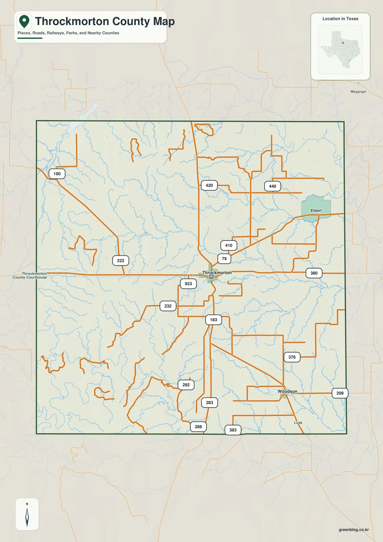
The blue drainage lines are almost as important as the roads. Numerous small channels cut across the interior and become especially noticeable in the west and south, where the terrain is more strongly dissected. The reference layer therefore gives an early clue that the county is not simply a flat ranch landscape; the water and elevation maps explain those valleys in much greater detail.
The ranked city map reduces the county to Throckmorton and Woodson
The ranked city map highlights only two major mapped communities. Throckmorton is marked as number 1 near the center, while Woodson is number 2 in the southeast. Removing most secondary labels makes the spacing between the two places much easier to see and gives a clear sense of how much rural land lies between the central county seat area and the southeastern settlement.
The CITY INDEX prints map values of 649 for Throckmorton and 504 for Woodson. Those values explain the ranking used in the supplied graphic and should be treated as map values rather than guaranteed current population estimates. For a map reader, the more useful information is the location relationship: Throckmorton is the central reference, while Woodson sits much closer to the southern and eastern sides of the county.
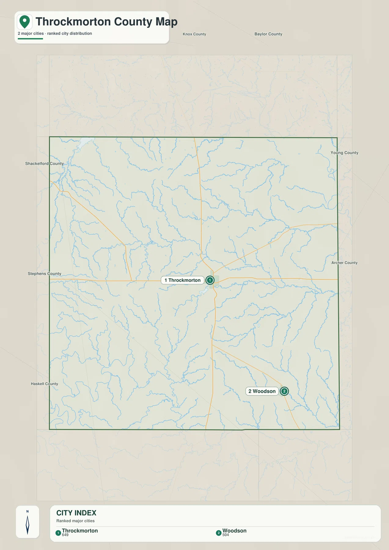
The surrounding county labels also help with orientation. Knox and Baylor counties appear to the north, Young and Archer counties are on the eastern side, and Stephens, Haskell, and Shackelford counties frame the south and west. With that larger context visible, it becomes clear why Woodson feels close to the southeastern edge while Throckmorton remains the county’s central geographic anchor.
North Elm Creek links the center while Clear Fork Brazos defines the southwest
The terrain-and-water map has several distinct water references rather than one dominant lake. North Elm Creek forms a long central drainage line that crosses much of the county from west toward east. Elm Creek Lake sits to the west of the central corridor, while Lake Throckmorton is closer to the middle and provides a recognizable water reference near the town of Throckmorton.
Millers Creek Reservoir appears near the northwestern edge, and the Brazos River is labeled along the northeastern side beyond the main county interior. Bush Knob Creek is a strong east-central channel. Farther southeast, Kings Creek runs toward the Woodson side, where Lake Woodson becomes the most obvious named water body. Brown Lake sits farther west of that southeastern cluster, showing that the county’s small lakes are distributed across several different drainage areas.
The most dramatic river feature is the Clear Fork Brazos River in the southwest. It follows a broad, winding valley along the lower western side of the county, where the relief map also shows some of the strongest topographic contrast. Compared with the gentler central North Elm Creek corridor, the Clear Fork occupies a more deeply cut landscape between higher ridges.
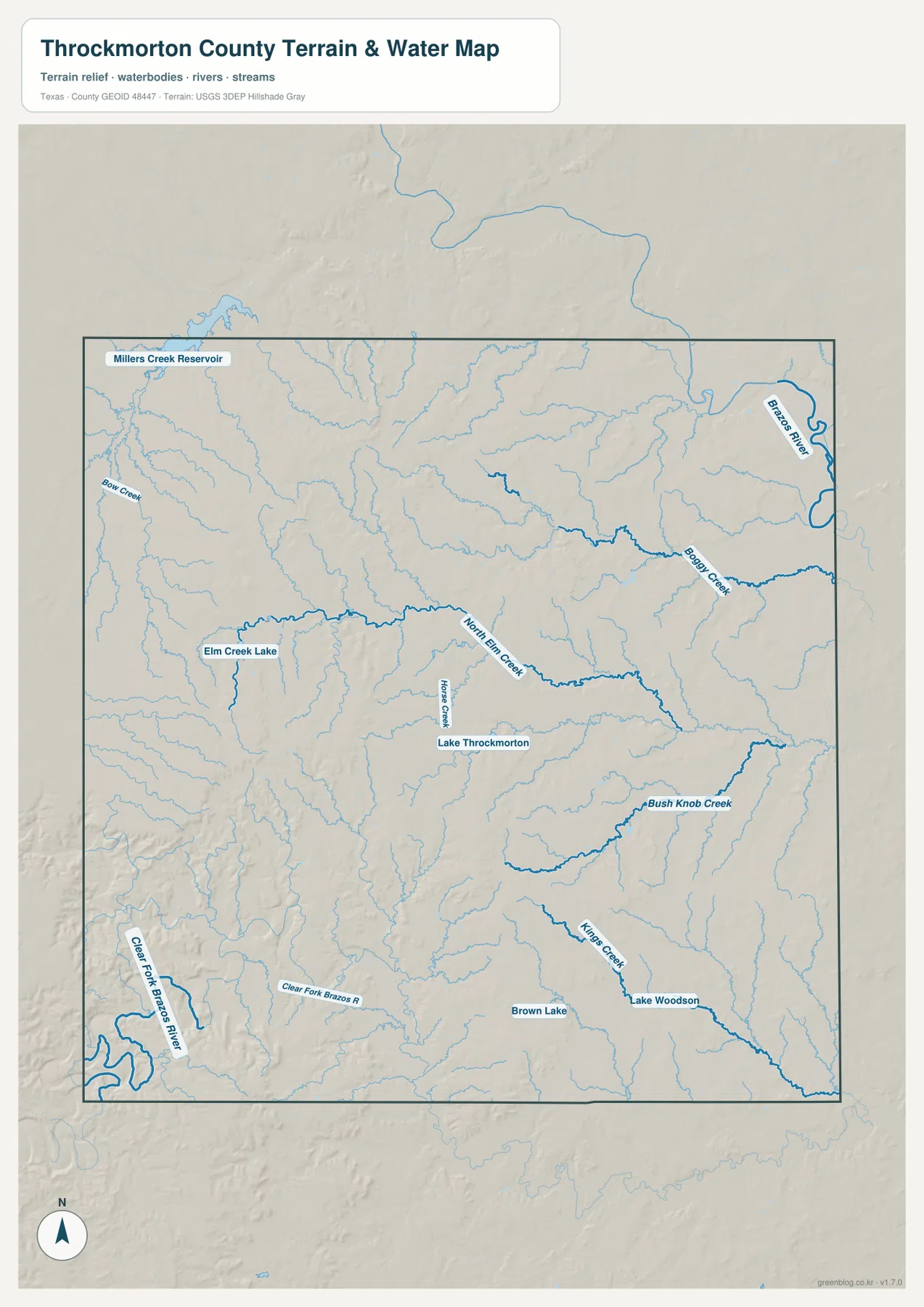
This layer is intended for geographic water and terrain reference rather than flood-risk analysis, parcel boundaries, navigation, or reservoir operations. Its most useful role here is to show which creek and river valleys correspond to the lower terrain on the elevation map and how the named lakes relate to Throckmorton and Woodson.
Western hills rise above the lower eastern half of the county
The elevation map reports an actual range of about 337 to 529 meters and a mean elevation of 416 meters. The strongest brown and tan high ground is concentrated in the west and southwest, with additional rugged ridges in the northwest. In contrast, broad green terrain covers much of the east and northeast, making the overall west-to-east height difference immediately visible.
The western uplands are not one continuous flat block. Narrow green valleys cut through the higher ridges, particularly around the Clear Fork Brazos River and its nearby drainage. Similar but gentler low corridors extend through the central interior where North Elm Creek and smaller tributaries cross the county. The eastern side is broadly lower, although small ridges and shallow drainage divides still remain.
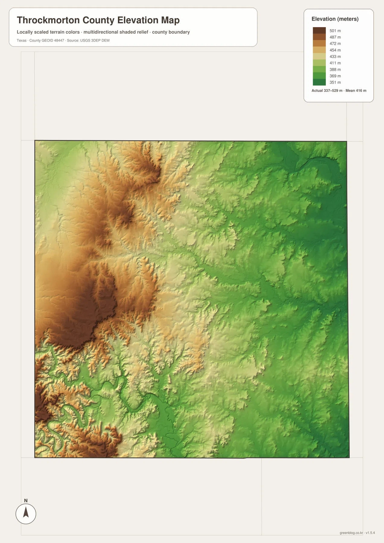
This countywide elevation surface is designed for broad terrain comparison rather than parcel surveying, engineering, or construction design. It is useful for seeing why the southwest looks more rugged, where the major creek valleys cut through the uplands, and how the land around Woodson differs from the higher western side. Exact site elevation should be checked with detailed source data or a local survey.
Choose the view by whether roads, towns, water, or relief matters most
Use the county reference map when Throckmorton, Woodson, Elbert, U.S. 380, U.S. 183, local route labels, and the county boundary need to appear together. The ranked city map is cleaner for comparing only Throckmorton and Woodson. The terrain-and-water layer is the best place to trace Clear Fork Brazos River, North Elm Creek, and the named lakes and reservoirs, while the elevation map makes the western hills and lower eastern terrain easiest to compare.
The downloadable ZIP contains four separate high-resolution A3 JPG files for Throckmorton County: county reference, ranked city, terrain and water, and elevation. You can inspect the WebP versions in the article first and then use the larger JPG files for printing, classroom material, presentations, or an editable local-reference document.
Frequently Asked Questions
Where is Woodson compared with Throckmorton?
Woodson is southeast of Throckmorton on the supplied maps. The ranked city view makes that relationship especially clear because it shows only the two main mapped communities.
Where does the Clear Fork Brazos River appear in Throckmorton County?
The terrain-and-water map shows the Clear Fork Brazos River along the southwestern side of the county. It occupies a lower winding valley below some of the county’s highest western terrain.
What elevation range is shown for Throckmorton County?
The supplied elevation map states an actual range of about 337 to 529 meters and a mean elevation of 416 meters. The west and southwest are generally higher, while the east and northeast are lower.
Map File Information
The ZIP contains the four Throckmorton County maps in high-resolution A3 JPG format.
- Included Versions: County reference, ranked city, terrain and water, elevation
- Included Files: 4 A3 JPG maps
Related Maps
Sources and data references
Roads, settlement locations, and the Throckmorton County boundary can be cross-checked with the U.S. Census Bureau TIGER/Line Shapefiles. Clear Fork Brazos River, North Elm Creek, lakes, and reservoir names can be checked against USGS National Hydrography, while terrain height data are available through the USGS 3D Elevation Program. City index values, route references, named waters, and the 337–529 meter elevation range described above are based on the Throckmorton County maps supplied in this package.
Green Map creates custom-edited map images using open geographic data sources such as geoBoundaries, Natural Earth, OpenStreetMap, and government open data.
These maps are edited visual materials, not raw data files, and are provided for education, documents, presentations, and graphic reference.