This Terry County Map set uses Brownfield as the central road and settlement reference, then adds the direct spacing of Meadow and Wellman, the small water features of the High Plains, and a gentle but clear elevation drop toward the east. Download the high-resolution A3 JPG map ZIP from the box below when you need printable or editable files; it contains separate county-reference, city-connections, terrain-and-water, and elevation maps.
Terry County looks broadly flat on the road map, but the other layers show more detail than the regular field grid suggests. Brownfield sits near the middle, Meadow is northeast, and Wellman is southwest. The terrain-and-water map emphasizes a small named lake and a long southern draw rather than major rivers, while the elevation map places the highest ground in the west and northwest and the lowest broad areas toward the east and southeast. Numerous shallow rounded depressions are visible across the plateau surface as well.
Table of Contents
Brownfield is the point where the road pattern becomes easiest to read
Brownfield is the first place to locate on the county reference map. Route shields 62 and 385 form the strongest north-south reference through the city area. West of Brownfield, shields 82 and 380 are shown on the main east-west approach, while 168 appears to the east and 137 is labeled on the southeastern road. Once Brownfield is fixed in the center, the outward road directions are easier to follow without treating every line as an equally important route.
Meadow lies northeast of Brownfield, and Wellman is southwest rather than southeast. Adair is labeled near the southern edge of the county, while Seagraves appears outside the southwest boundary. Terry County Airport is marked just east of Brownfield, adding another useful reference for the central built-up area. These labels make the county’s sparse settlement pattern much easier to understand than a road-only description.
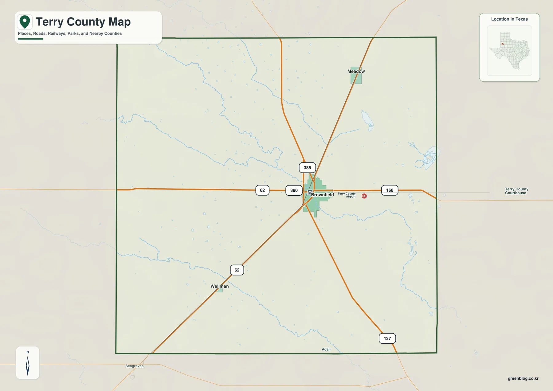
The background drainage is subtle but important. Thin blue channels and small basins interrupt an otherwise regular agricultural grid, especially toward the east and along several faint low corridors. The county reference map therefore gives a first hint that the Southern High Plains surface is not perfectly level even where roads and fields appear very orderly.
The city-connections view separates Meadow and Wellman on opposite sides of Brownfield
The city-connections map uses Brownfield as the hub and draws direct links to the two smaller ranked communities. Meadow is northeast of Brownfield at about 12 miles by the map’s straight-line measurement. Wellman is southwest and is shown about 13 miles from Brownfield. These are point-to-point map distances rather than driving mileages, so road travel will depend on the exact route and starting location.
The CITY CONNECTIONS panel prints map values of 8,738 for Brownfield, 623 for Meadow, and 286 for Wellman. Those values explain the ranking and relative symbol order used in this graphic; they should not be treated as guaranteed current population estimates. For geographic use, the important relationship is that Brownfield is the clear hub while Meadow and Wellman occupy opposite diagonal directions.
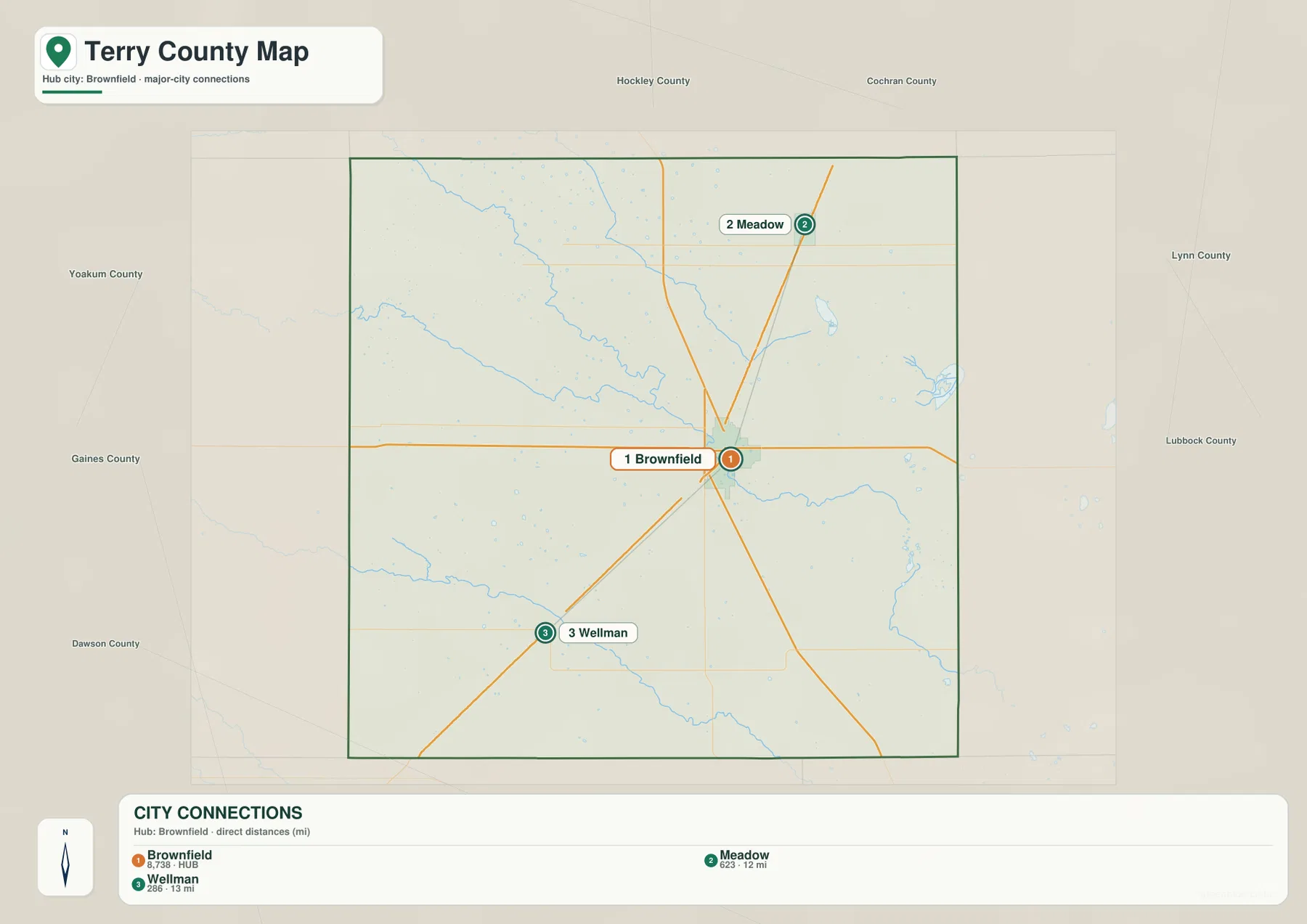
Neighboring county names add another layer of orientation. Hockley and Cochran counties are shown along the north, Yoakum and Gaines on the western side, Dawson to the south, and Lynn and Lubbock to the east. Because the Terry County outline is compact and nearly rectangular, Brownfield’s central position is especially obvious when those surrounding names are visible.
Rich Lake and Sulphur Springs Draw show a water landscape without large rivers
The terrain-and-water map has only a few prominent named features, which is useful information in itself. Rich Lake appears in the northeastern part of the county as a small isolated water body surrounded by shallow relief. Nearby short drainage lines and rounded depressions reinforce the impression of a High Plains landscape where water often occupies small local lows rather than long connected river valleys.
Sulphur Springs Draw enters from the southwest and follows a long low corridor across the southern part of the county. It does not look like a broad permanent river channel; instead, the map shows a narrow drainage line following the lowest available terrain. Unnamed shallow channels also cross the north and center, so the water layer is best read as a network of small depressions and draws rather than a map dominated by lakes or major rivers.
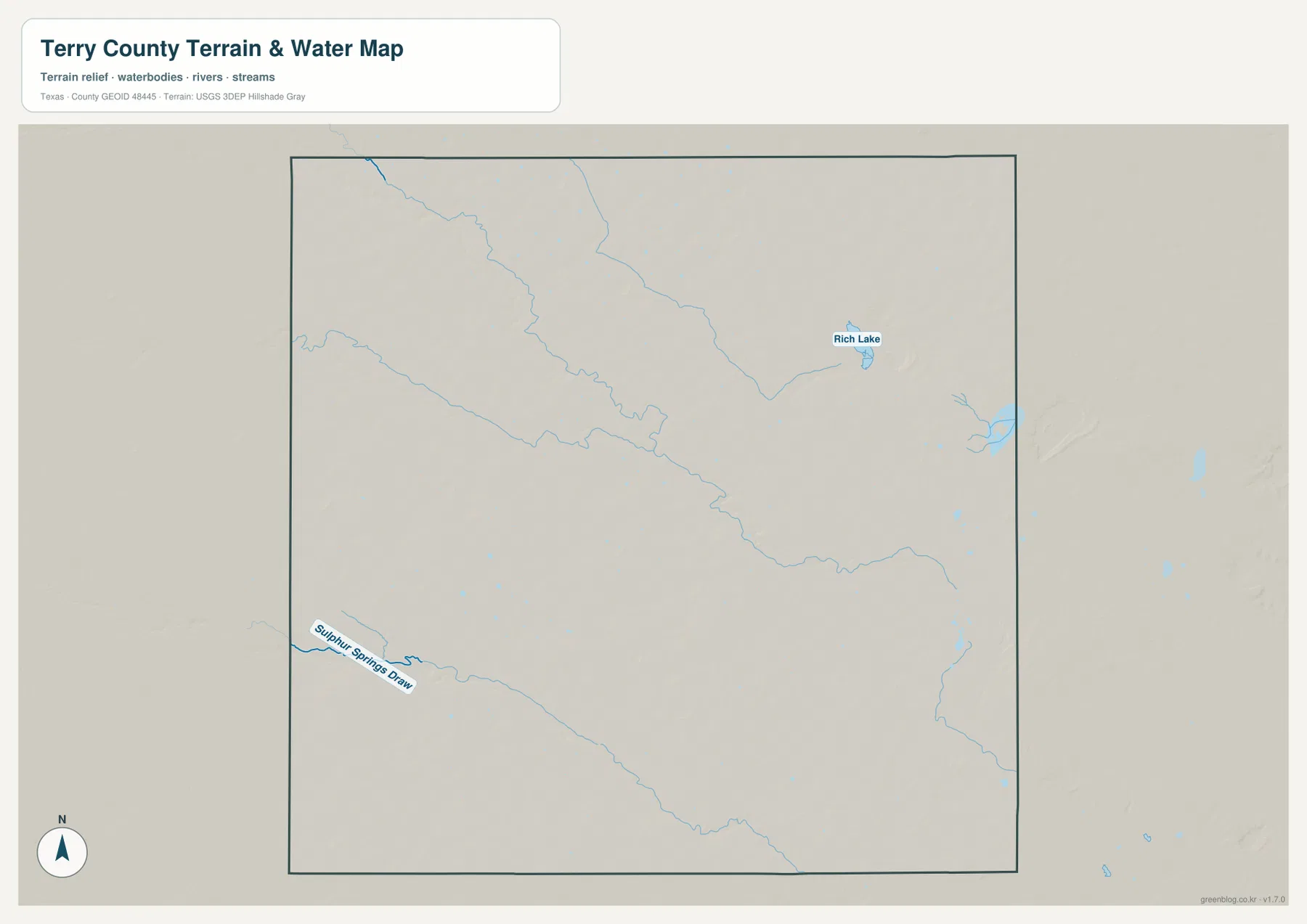
This layer is intended for geographic water and terrain reference rather than flood-hazard analysis, parcel boundaries, irrigation operations, or water-depth decisions. Shallow playa-like depressions can change in appearance with local conditions. The useful information here is their position relative to Brownfield and the broader southward and eastward drainage pattern.
Elevation drops from the western plateau toward the east and southeast
The elevation map reports an actual range of about 938 to 1,099 meters and a mean elevation of 1,017 meters. The darkest brown high ground covers much of the west and northwest. Colors become lighter across the central interior and shift to broad green lowlands in the east and southeast, producing a clear countywide west-to-east contrast.
The relief is gentle compared with a mountainous county, but the surface is not featureless. Numerous rounded shallow lows are visible across the plateau, including many in the eastern and northeastern half. Narrow green corridors also trace parts of the drainage network. Comparing the relief layer with the water map helps explain why Rich Lake occupies a local depression and why Sulphur Springs Draw follows a lower southern pathway.
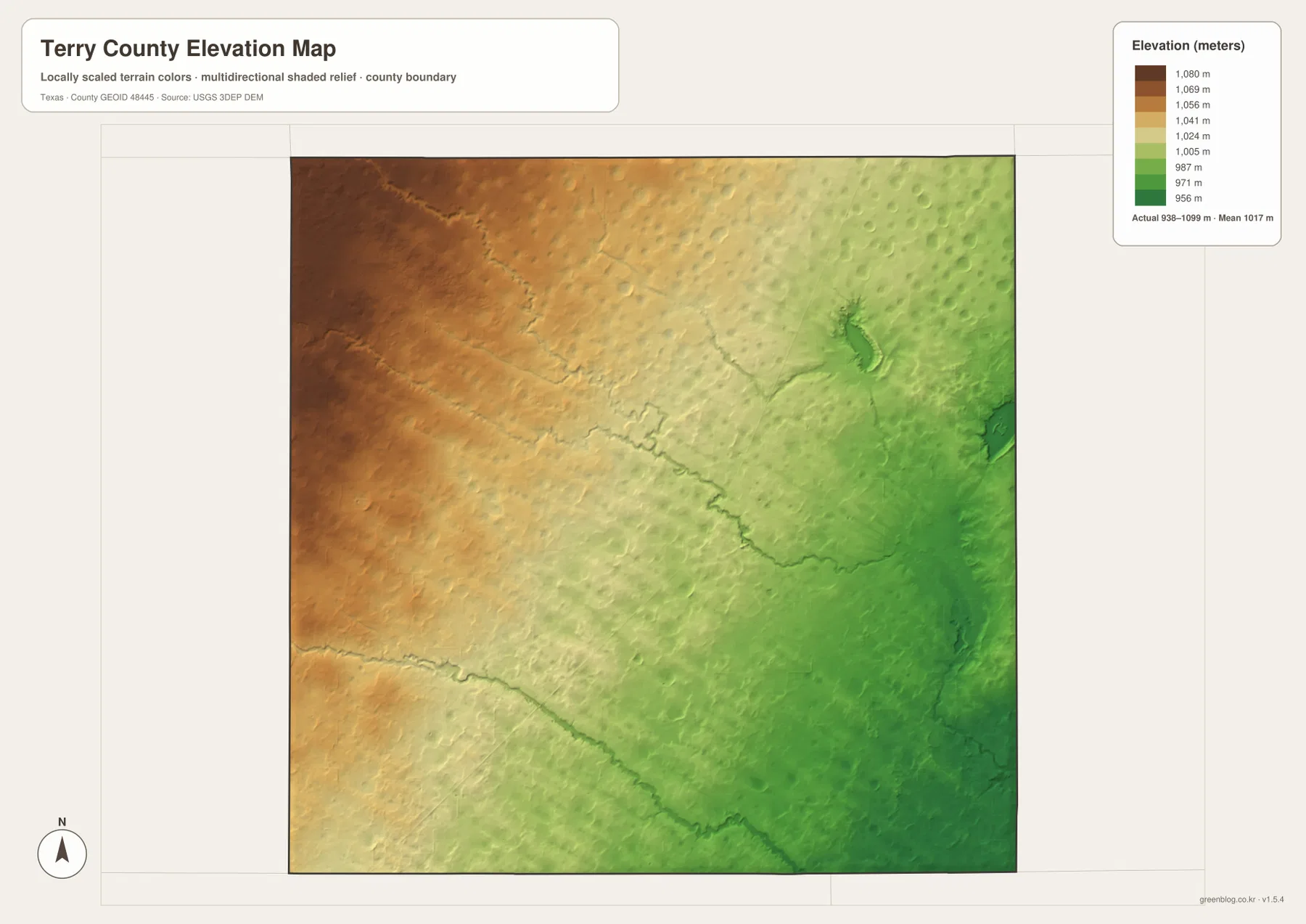
This countywide elevation surface is designed for broad terrain comparison rather than parcel surveying, engineering, or construction design. It is useful for placing Brownfield between the higher western plateau and lower eastern ground, and for seeing how small draws and depressions occupy local lows. Exact site elevation should be checked with detailed source data or a local survey.
Choose the map by whether roads, town spacing, water, or relief matters most
Use the county reference map when Brownfield, Meadow, Wellman, road labels, the airport, and the county boundary need to appear together. The city-connections map is cleaner for comparing the direct distance and direction from Brownfield to the two smaller communities. The terrain-and-water layer is the best place to locate Rich Lake and Sulphur Springs Draw, while the elevation map makes the higher west and lower east easiest to compare.
The downloadable ZIP contains four separate high-resolution A3 JPG files for Terry County: county reference, city connections, terrain and water, and elevation. You can inspect the lighter WebP versions in the article first and then use the larger JPG files for printing, classroom material, presentations, or an editable local-reference document.
Frequently Asked Questions
Are Meadow and Wellman on the same side of Brownfield?
No. The supplied city-connections map places Meadow northeast of Brownfield and Wellman southwest. Their direct mapped distances are about 12 miles and 13 miles, respectively.
Which named water features are easiest to find on the Terry County map?
Rich Lake in the northeast and Sulphur Springs Draw across the southern part of the county are the clearest named water references on the supplied terrain-and-water map. Other shallow channels and depressions are visible but are not assigned invented names here.
What elevation range is shown for Terry County?
The supplied elevation map states an actual range of about 938 to 1,099 meters and a mean elevation of 1,017 meters. The west and northwest are higher, while the east and southeast are lower.
Map File Information
The ZIP contains the four Terry County maps in high-resolution A3 JPG format.
- Included Versions: County reference, city connections, terrain and water, elevation
- Included Files: 4 A3 JPG maps
Related Maps
Sources and data references
Roads, place locations, and the Terry County boundary can be cross-checked with the U.S. Census Bureau TIGER/Line Shapefiles. Rich Lake, Sulphur Springs Draw, and other drainage features can be checked against USGS National Hydrography, while terrain height data are available through the USGS 3D Elevation Program. Town distances, route labels, named water features, and the 938–1,099 meter elevation range described above are based on the Terry County maps supplied in this package.
Green Map creates custom-edited map images using open geographic data sources such as geoBoundaries, Natural Earth, OpenStreetMap, and government open data.
These maps are edited visual materials, not raw data files, and are provided for education, documents, presentations, and graphic reference.