This Pinellas County Map is useful because the county is not a simple inland block. It occupies a long, narrow peninsula on Florida’s Gulf Coast, with Gulf water to the west, Tampa Bay waters to the east, and a chain of beach communities and islands along the outer shore. Tarpon Springs sits near the northern end, Clearwater anchors the north-central area, and St. Petersburg spreads across much of the southern peninsula. That shape makes water and bridge connections just as important as road lines when you are trying to understand where places actually sit.
The page includes a general county map, a ranked major-city map, and a terrain-and-water map. Together they let you move from a broad view of roads and municipal centers to a clearer look at bays, creeks, canals, and the shoreline. A downloadable ZIP with three high-resolution A3 JPG files is also provided below for printing, trip notes, classroom work, or personal reference.
Table of Contents
A county shaped by water on nearly every side
Pinellas County connects directly to Pasco County at the north, but much of the rest of its outline is water-facing. Old Tampa Bay and Tampa Bay lie along the east and southeast, while the Gulf shore runs down the west. Boca Ciega Bay cuts into the southwest side between the mainland and the barrier-island communities. The result is a county where two places can look close on a small-scale map yet require a much longer drive because a bay, inlet, or island channel lies between them.
The general map makes the long north-south form easy to recognize. Tarpon Springs appears near the top, followed southward by Dunedin and Clearwater. Largo, Seminole, and Pinellas Park occupy the central part of the county, while St. Petersburg dominates the lower peninsula. Gulfport sits on the Boca Ciega Bay side, and the land narrows again toward Tierra Verde and the Fort De Soto area at the south.
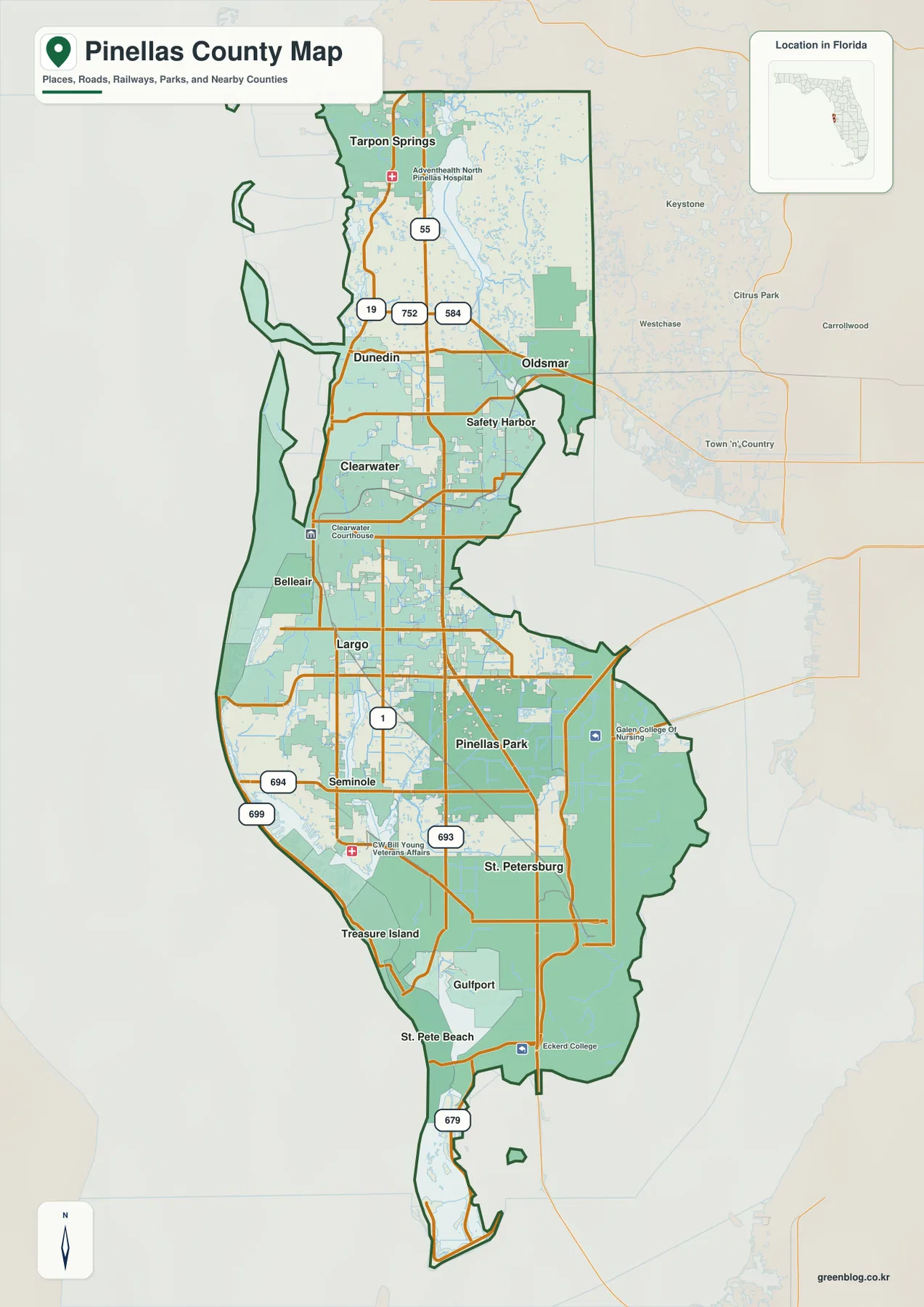
The west edge needs a separate look because the beach side is not simply the mainland coast. Several narrow islands and beach municipalities run parallel to the peninsula, separated from the mainland by bays and channels. On the east, Tampa Bay also presses deeply against the county. Those two water-facing sides explain why the map looks unusually narrow in places and why east-west trips often depend on a limited number of causeways or bridges.
Six city anchors across a narrow urban peninsula
The city map ranks six major municipalities and gives a quick way to organize the county before looking at smaller communities. St. Petersburg is shown as the largest of the six and occupies the southern part of the peninsula. Clearwater, the county seat, is farther north. Largo and Pinellas Park fill much of the middle, while Dunedin and Tarpon Springs continue the sequence toward the Pasco County line. Seeing that order first makes it easier to place other names that appear on the general map.
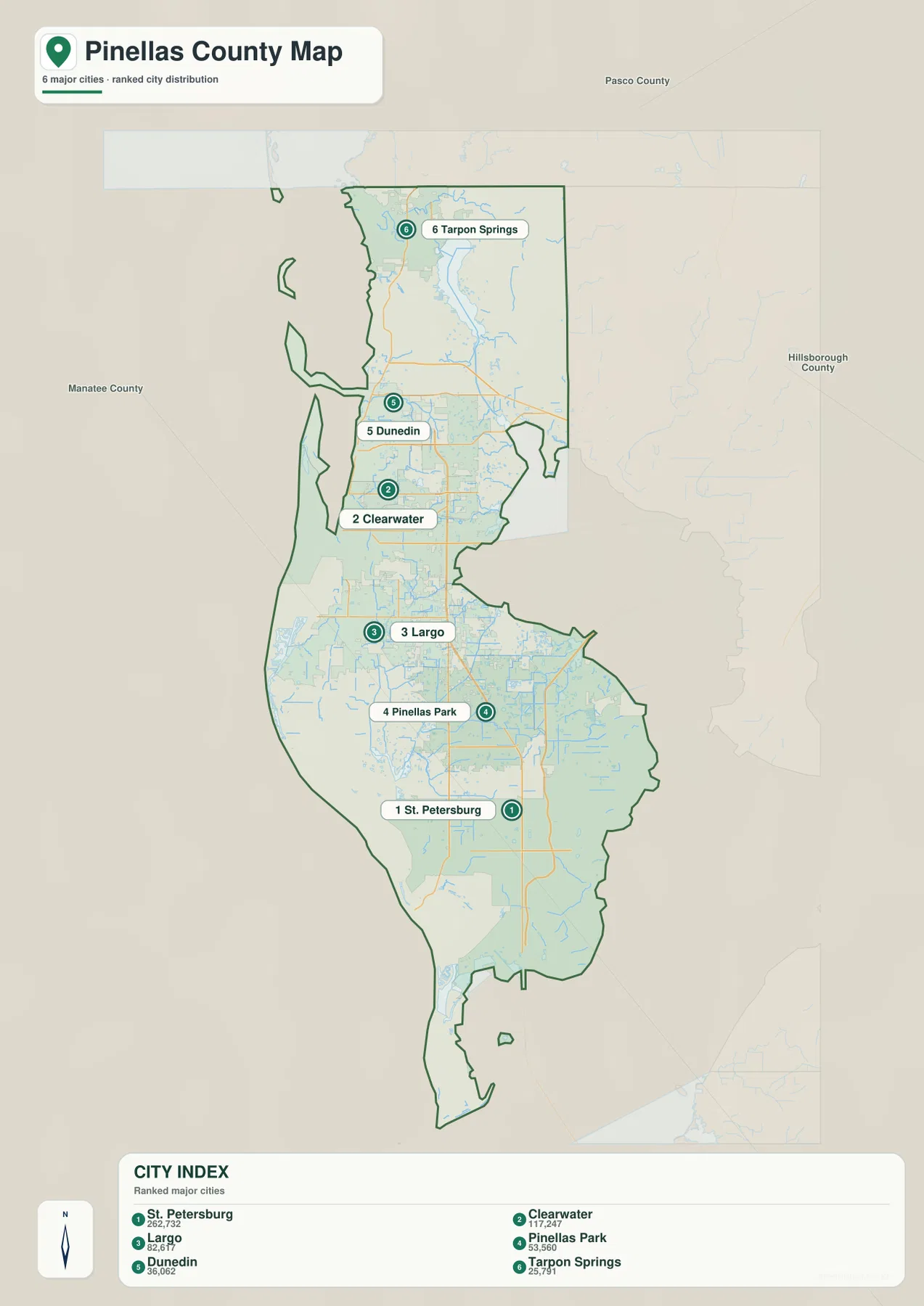
The surrounding-county labels are also useful. Pasco County is immediately north, Hillsborough County lies across the bay to the east, and Manatee County is beyond lower Tampa Bay to the south. Only the northern connection is a straightforward land continuation. Reaching Tampa and other Hillsborough destinations requires a bay crossing, and travel toward Manatee County from southern Pinellas relies on the lower-bay connection rather than a normal shared land boundary.
Clearwater and Clearwater Beach are a good example of why place names alone can be misleading. Downtown Clearwater and the county-government area are on the mainland, while Clearwater Beach sits across the water on the Gulf side. St. Petersburg and St. Pete Beach are similarly distinct locations: one is the large southern mainland city, while the beach municipality lies across Boca Ciega Bay on the barrier-island side. The county map is most useful when those names are read together with the surrounding water.
Why short straight-line distances can turn into longer trips
Pinellas County’s stretched shape puts heavy emphasis on north-south corridors. The package’s existing reference material identifies U.S. 19 as a principal mainland route serving the Clearwater, Largo, and Pinellas Park areas and continuing north toward Tarpon Springs. I-275 serves St. Petersburg and the eastern side of the lower peninsula, then connects across Tampa Bay and across the lower bay in opposite directions. The two routes may look roughly parallel on a broad map, but they serve different parts of the county and different regional destinations.
East-west travel is defined by a small number of major crossings. State Road 60 links Clearwater and Clearwater Beach with the Courtney Campbell Causeway toward Tampa. Farther south, the Howard Frankland and Gandy bridges provide additional Tampa Bay crossings from the St. Petersburg side of the county. At the southern end, the Sunshine Skyway carries I-275 across lower Tampa Bay toward Manatee County. The best crossing therefore depends on where a trip begins rather than simply on which bridge looks closest on a statewide map.
The Gulf beach chain creates a similar issue at a smaller scale. Clearwater Beach, Belleair-area beaches, Treasure Island, and St. Pete Beach appear as a nearly continuous coastal strip, but inlets and channels divide the islands and limit direct access from the mainland. A practical route map should pair each beach destination with its nearest causeway or bridge instead of treating Gulf Boulevard as if every point along the shore had the same mainland connection.
From Lake Tarpon to Boca Ciega Bay
The water map removes much of the city detail and makes the county’s hydrology easier to follow. Near the north, the Anclote River and the Lake Tarpon area stand out, with Hollin Creek and Curlew Creek labeled nearby. Moving south, Stevenson Creek, Alligator Creek, and Allen Creek show how small waterways cross the developed peninsula toward larger coastal waters. Farther down, Cross Bayou Canal and Long Bayou appear within the more intricate network of south-central and southwestern water bodies.
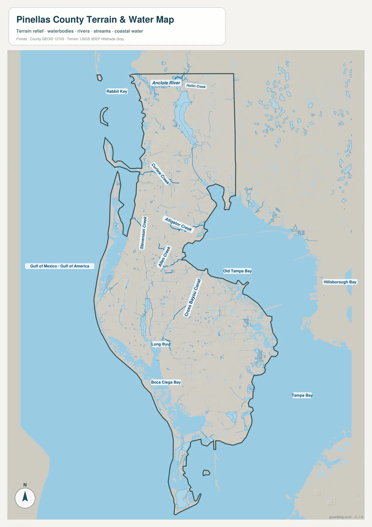
Old Tampa Bay occupies the northeastern side of the county, Tampa Bay opens along the southeast, and Boca Ciega Bay lies on the southwest between St. Petersburg and the outer beach communities. The Gulf-facing west side has a different appearance, with long beach islands and open coastal water. These contrasts matter because the same word “coast” can refer to very different settings within one county: an exposed Gulf beach, a sheltered bay shore, a creek mouth, or a narrow channel between islands.
Lake Tarpon is especially useful as a northern landmark. The package’s county references describe it as the largest freshwater lake in the Tampa Bay area, and it is visibly large enough on the water map to interrupt the otherwise urban pattern. It sits inland from the Gulf coast near the northern communities, so it helps explain why roads and neighborhoods in that part of the county do not form one simple strip along the shore.
Reading the beach chain separately from the mainland
The outer coast deserves its own mental layer. In the north, the package references Honeymoon Island and Caladesi Island, while the central and southern coast continues through a long series of beach communities. Their positions can look almost attached to the mainland at a small scale, but the water map shows why access points matter. Channels, passes, and the Intracoastal side of the barrier islands separate the beach strip from inland cities such as Clearwater, Largo, and Seminole.
Two protected areas in the package’s official-link catalog also help show how much coastal habitat remains inside this heavily urbanized county. Weedon Island Preserve lies on the Tampa Bay side of northeast St. Petersburg, while Fort De Soto Park occupies the far southern end among connected keys and surrounding water. Marking both on a printed map gives a useful east-versus-south comparison and prevents the lower county from looking like one continuous urban surface.
The Fred Marquis Pinellas Trail provides another way to understand the long urban sequence. The existing county material describes the trail as running from St. Petersburg to Tarpon Springs through multiple western and central communities. It is not a substitute for the highway map, but it is a useful reference line for seeing how many of the county’s cities are arranged along the same general north-south direction.
Choose the right Pinellas County map for the task
Use the general county map when you need roads, place names, and the overall outline on one page. It works well for locating Clearwater relative to St. Petersburg, following the county north toward Tarpon Springs, or checking whether a destination is on the mainland or close to the Gulf side. The city map is cleaner when your main question is how the largest municipalities are distributed. The water map is the better choice for bays, creeks, canals, coastal islands, and the shape of the peninsula itself.
For route planning or location study, combining them is often more informative than using one image alone. A Clearwater Beach trip, for example, can start with the county map to identify the road connection, shift to the water map to see the barrier between beach and mainland, and then use the city map to place Clearwater within the larger north-south chain. The same approach works for St. Pete Beach, Tierra Verde, Fort De Soto, or any destination where water changes the directness of travel.
The downloadable JPG files are intended for higher-resolution use than the on-page WebP previews. They are convenient when you want to add your own labels, mark a bridge crossing, compare beach access points, or print the county at a larger size. For road closures, construction, or other details that can change over time, confirm current conditions with the relevant official source before traveling.
Frequently Asked Questions
What is the county seat of Pinellas County?
Clearwater is the county seat. St. Petersburg is the largest city shown on the package’s city map, so it is easy to assume that the largest city is also the administrative center, but the two roles belong to different places.
Why are Clearwater and Clearwater Beach separated on the map?
Mainland Clearwater and Clearwater Beach are separated by coastal water. The beach is on the Gulf-side barrier-island setting, so a road connection and causeway are needed to move between the two. That is why the water map is useful even when the city names sound almost identical.
Which water features are easiest to identify on the Pinellas County water map?
Lake Tarpon and the Anclote River stand out in the north, while Old Tampa Bay, Tampa Bay, and Boca Ciega Bay define much of the eastern and southwestern shoreline. Smaller labeled features such as Curlew Creek, Alligator Creek, Cross Bayou Canal, and Long Bayou provide more local detail once the larger waters are identified.
Map File Information
The ZIP contains high-resolution A3 JPG versions of the Pinellas County general map, major-city map, and terrain-and-water map.
- Included Versions: county map, city map, water map
- Included Files: 3 A3 JPG maps
Related Maps
- Arcadia Roads and Peace River | DeSoto County Florida Map
- Baker County Florida Map
- Between the Aucilla and Withlacoochee: Madison County Florida Map
Sources
- U.S. Census Bureau: Pinellas County QuickFacts
- Pinellas County municipalities and cities
- Florida Department of Transportation county highway maps
- Southwest Florida Water Management District: Lake Tarpon
- Pinellas County: Weedon Island Preserve
- Pinellas County: Fort De Soto Park
Green Map creates custom-edited map images using open geographic data sources such as geoBoundaries, Natural Earth, OpenStreetMap, and government open data. These maps are edited visual materials, not raw data files, and are provided for education, documents, presentations, and graphic reference.