A Polk County, Florida map makes the county easier to understand once you stop looking for a single dominant center. Lakeland anchors the west, Winter Haven sits among a dense group of central lakes, Bartow serves as the county seat farther south, and Lake Wales helps define the eastern side. Those places are separated by enough distance, water, and different highway corridors that Polk works better as a set of connected districts than as one compact urban area.
This page includes a general county map with roads and place names, a city map that compares six major cities, and a terrain-and-water map that highlights lakes, streams, and rivers. After reviewing the on-page maps, you can also download a ZIP containing three high-resolution A3 JPG files for printing, note-taking, classroom reference, or your own county study.
Table of Contents
A large inland county between the Tampa and Orlando regions
Polk County covers enough ground that its internal geography matters as much as its position in central Florida. The source material in this package lists a 2020 population of 725,046 and a land area of 1,797.76 square miles. On the maps, the county stretches from Lakeland and Mulberry in the west through the Winter Haven lake district and Bartow, then east toward Haines City, Dundee, Lake Wales, and the long US 27 corridor. Farther south, Fort Meade and Frostproof sit with noticeably more open space around them.
The general county map is useful because it shows those places together instead of isolating one city. Lakeland lies close to the western edge. Auburndale and Winter Haven occupy the central area, where lakes break up the land surface. Bartow is south of that cluster, while Haines City, Lake Hamilton, Dundee, and Lake Wales align farther east. Polk City and Lake Alfred help connect the northern and central portions, and Frostproof extends the eastern settlement pattern well toward the south.
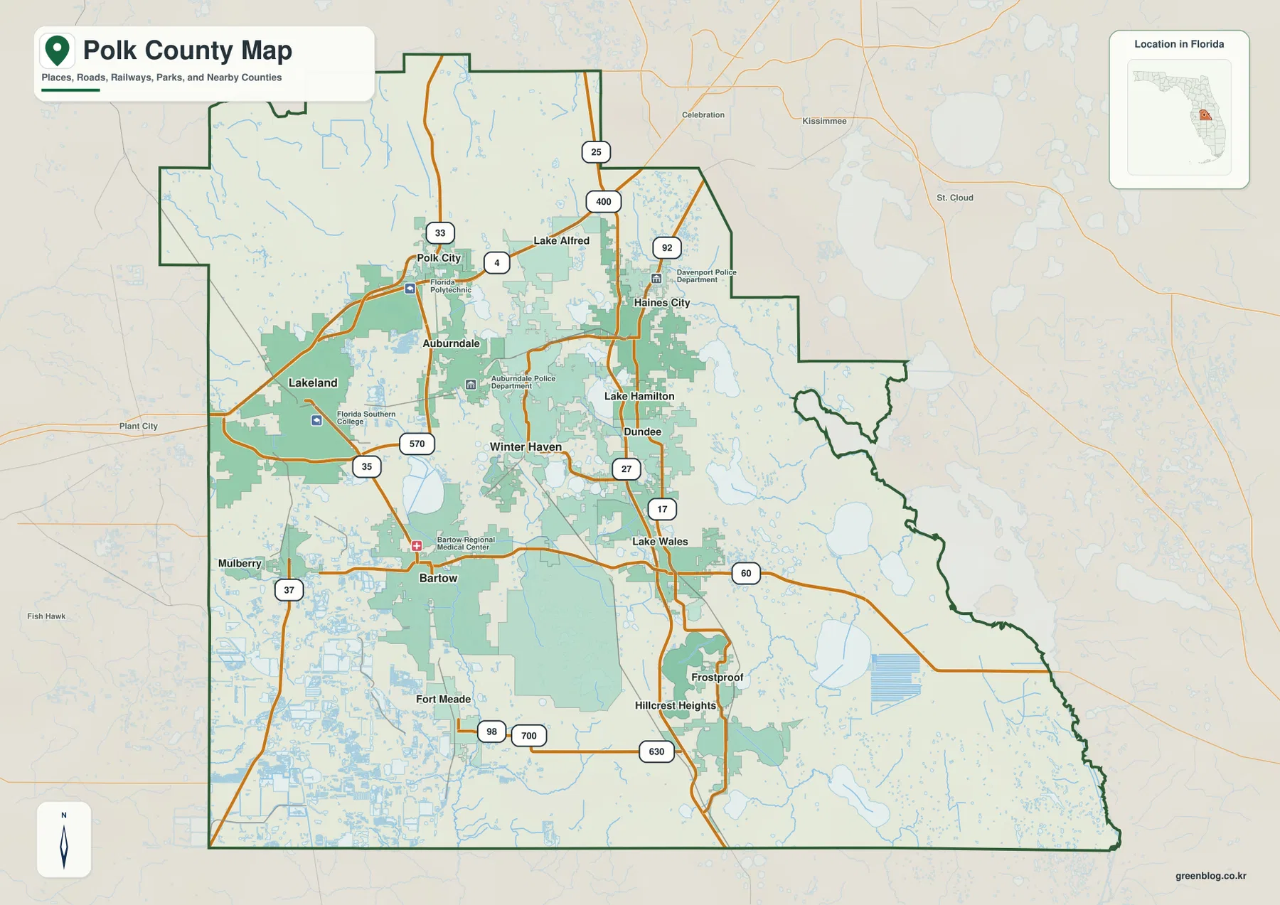
The package also identifies Polk’s neighboring counties as Hillsborough to the west, Pasco to the northwest, Sumter and Lake to the north, Orange at the northeastern tip, Osceola to the east, Highlands to the southeast, Hardee to the south, and Manatee at the southwest corner. Several of those names are visible around the city-map frame. That boundary context is especially helpful when a route leaves Polk, because a trip that looks local at county scale can quickly continue into the Tampa or Orlando side of central Florida.
Lakeland, Winter Haven, and Bartow do different jobs on the map
The city map ranks Lakeland first among the six highlighted cities and Winter Haven second. Haines City, Bartow, Auburndale, and Lake Wales complete the displayed group. Their distribution is more important than the ranking itself: Lakeland is clearly western, Winter Haven and Auburndale occupy the lake-rich center, Haines City and Lake Wales sit toward the east, and Bartow lies farther south. That arrangement gives visitors several practical anchors instead of one central downtown.
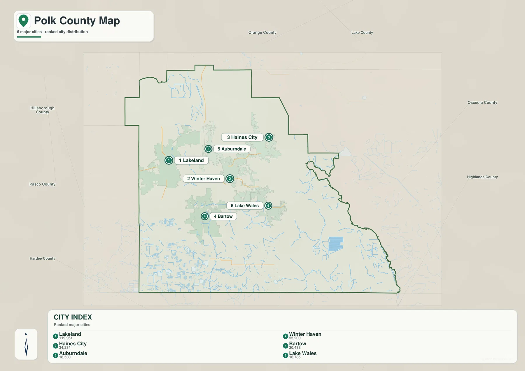
Bartow is a good example of why size and administrative role should not be confused. Lakeland is the largest city shown on the map, but Bartow is the county seat. Someone looking for county government and someone looking for the largest urban center may therefore be traveling to different places. This distinction also affects how the road map is read, because routes from Lakeland, Winter Haven, and the US 27 communities approach Bartow from different directions.
Winter Haven stands out for another reason: water surrounds the city on the broader map. The city and water views together show many lakes packed into the central area, with roads threading between them. Auburndale and Lake Alfred are close by, and names such as Lake Hamilton reinforce how strongly water shapes the settlement pattern. A small-scale road map can make this area look like a typical urban cluster, but the water map explains why the street and city pattern is less regular than it first appears.
I-4 and US 27 organize travel in two different directions
For regional travel, I-4 is the first highway to locate in northern Polk. The package describes it as the major east-west route between the Tampa and Orlando regions. It passes north of Lakeland, connects with SR 570, and meets US 27 in northeastern Polk. That makes it important for trips that cross the county or approach it from the two major metropolitan areas rather than head directly for Bartow or the central lake district.
US 27 has a different role. It runs north-south through the eastern side and links the Davenport and Haines City area with Lake Wales and Frostproof. If your destination is on the eastern side of the county, US 27 often provides a clearer orientation than I-4. SR 60 crosses Bartow and continues toward Lake Wales, creating the main east-west connection between the county seat and the eastern corridor.
Western and central Polk rely on several other routes shown in the source material. US 98 runs from Lakeland through Bartow toward Fort Meade. US 17 connects the Winter Haven area with Bartow and Fort Meade, while SR 570, the Polk Parkway, curves around the Lakeland area and ties into major roads including I-4, US 98, and US 92. The result is a network with multiple centers, not a simple set of highways radiating from the county seat.
A useful way to simplify the map is to match one corridor to one broad task. Think of I-4 for the Tampa-to-Orlando direction, US 27 for eastern north-south travel, US 98 for the Lakeland-to-Bartow connection, and SR 60 for Bartow toward Lake Wales. Live navigation is still necessary for exact turns and current conditions, but those four routes provide a strong first layer for reading the county at a glance.
The Winter Haven lake district feeds into a larger river system
The terrain-and-water map changes the way central Polk looks. Instead of emphasizing city labels, it reveals a dense field of lakes around the central and west-central part of the county. Lake Parker, Lake Ariana, Lake Mattie, Bay Lake, Lake Fannie, Sears Lake, and Lake Eloise are among the labeled waters. Their close spacing helps explain why communities such as Winter Haven and Auburndale are surrounded by irregular shorelines and why roads often bend through narrow strips of land between water bodies.
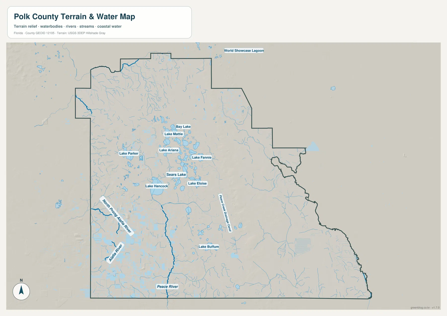
Lake Hancock is one of the most prominent labeled lakes. The package’s existing material describes it as covering more than 4,500 acres and places it near the headwaters of the Peace River. Saddle Creek flows through the lake, and the source material explains that it joins the Peace Creek Drainage Canal northeast of Bartow, where the Peace River begins. On the water map, the Peace River then continues southward, making the connection between the central lake district and a much larger river system easier to visualize.
Not all of Polk drains in the same direction. The map labels the North Prong Alafia River and the Alafia River on the western side, while the package also notes that northern Polk includes part of Green Swamp, an important central Florida hydrologic area. This is why it is better to think of Polk as several connected drainage areas rather than one single lake basin. The lakes are visually dominant, but they feed or relate to different downstream systems.
Lake Wales Ridge changes the eastern side of the county
The eastern side of Polk is described in the package as part of the Lake Wales Ridge, a long sandy upland that differs from the flatter wetlands and densely spaced central lakes. Lake Wales and Frostproof fit that north-south pattern, and US 27 follows the same broad side of the county. When the city and water maps are viewed together, the eastern corridor looks less like an extension of Winter Haven and more like a separate strip with its own topographic and transportation identity.
Southern Polk also feels more open on the maps. Fort Meade lies south of Bartow, while Frostproof sits well to the southeast, and large areas between major labels contain fewer highlighted cities than the north. This contrast is useful when comparing the I-4 growth corridor, the central lake district, the US 27 corridor, and the broader southern part of the county. Printing the map and marking those four zones can make the county’s large scale much easier to grasp.
The source material also notes extensive landscapes in southwestern Polk that have been altered by phosphate mining and reclamation. The maps on this page are not parcel-level land-use maps, however, and they do not define mine boundaries, ownership, or legal access. For those questions, the package specifically points readers toward current Polk County GIS information rather than treating a county-scale reference map as a substitute.
Choose the Polk County map that matches your question
The general county map is the best starting point when you need roads, city names, and the overall county outline together. It works well for comparing Lakeland with Bartow, locating Winter Haven relative to Lake Wales, or following the major highway corridors. The city map is cleaner when the main goal is to compare the six highlighted urban centers without as much road detail. The water map is the better choice for lake clusters, rivers, streams, and the relationship between Lake Hancock and the Peace River system.
Using two maps together often answers a question faster than forcing one map to do everything. A Winter Haven study can begin with the city map to place it between Lakeland, Bartow, and Haines City, switch to the county map for US 17 and nearby roads, and then use the water map to see how closely lakes such as Lake Eloise and Lake Fannie sit around the urban area. For Lake Wales, the city map provides the eastern position while the county map makes US 27 and SR 60 easy to identify.
The downloadable JPG files are intended for higher-resolution use than the WebP previews shown in the article. They are convenient when you want to add route notes, mark a city or lake, compare neighboring counties, or print the map for a class or personal project. For temporary road changes, access restrictions, or parcel-level questions, confirm the latest information with the relevant official source before relying on the map for travel or field use.
Frequently Asked Questions
Is Lakeland the county seat of Polk County?
No. Lakeland is the largest city highlighted on the package’s city map, but Bartow is the county seat. That distinction matters when planning a trip for county-government business because the largest urban center and the administrative center are in different places.
Which map best shows why Winter Haven is surrounded by so many lakes?
The terrain-and-water map is the clearest choice. It shows many central lakes close together, including Lake Eloise, Lake Fannie, and Sears Lake, while also showing Lake Hancock and the larger Peace River system. Use the general county map beside it if you also need roads and city labels.
How do I-4 and US 27 divide the main travel directions in Polk County?
I-4 runs across the northern part of the county and is the main regional route in the Tampa-Orlando direction. US 27 runs north-south on the eastern side through the Haines City and Lake Wales corridor. Identifying which of those two directions your destination belongs to makes the rest of the road map much easier to follow.
Map File Information
The ZIP contains high-resolution A3 JPG versions of the Polk County general map, major-city map, and terrain-and-water map.
- Included Versions: county map, city map, water map
- Included Files: 3 A3 JPG maps
Related Maps
- Arcadia Roads and Peace River | DeSoto County Florida Map
- Baker County Florida Map
- Between the Aucilla and Withlacoochee: Madison County Florida Map
Sources
- U.S. Census Bureau: Polk County QuickFacts
- Polk County GIS
- Florida Department of Transportation: County General Highway Maps
- Southwest Florida Water Management District: Green Swamp watersheds
- Southwest Florida Water Management District: Lake Hancock
Green Map creates custom-edited map images using open geographic data sources such as geoBoundaries, Natural Earth, OpenStreetMap, and government open data.
These maps are edited visual materials, not raw data files, and are provided for education, documents, presentations, and graphic reference.