Madison County Florida Map readers can orient themselves quickly by starting with the city of Madison and the US 90 corridor. Greenville lies to the west, Lee lies to the east, and the county reaches north to the Georgia state line. The page separates county roads and boundaries, city connections, and waterways so each map has a clear purpose. High-resolution A3 JPG copies of the same three maps are also available below in one downloadable ZIP file.
Madison County is easier to understand as a broad rural county organized around a few towns, long east-west roads, and rivers near its outer edges. US 90 links Greenville, Madison, and Lee through the middle of the county, while I-10 passes farther south and serves longer-distance travel. On the water map, the Withlacoochee River stands out along the eastern side and the Aucilla system appears on the west and southwest. Looking at those features together gives a much clearer sense of the county than a single road map can provide.
Table of Contents
US 90 ties together Greenville, Madison, and Lee
Madison is the most useful starting point on the county map. It sits near the center of the county and serves as the county seat, with US 90 running through town and SR 53 providing a north-south route. Greenville is west of Madison on US 90, while Lee is east of it. That arrangement makes the main settled corridor easy to follow even before looking at smaller roads. The map also shows that the three communities are not isolated dots: each connects to a different set of roads leading into the surrounding rural areas.
I-10 crosses Madison County south of the US 90 towns. For drivers passing through north Florida, the interstate may be the most familiar feature, but it does not run directly through downtown Madison, Greenville, or Lee. US 90 is therefore the better line to follow when the goal is to understand local town locations. US 221 runs north-south near Greenville, while SR 53 connects Madison with areas to the north and with I-10 to the south. Farther east, roads around Lee continue toward Suwannee County.
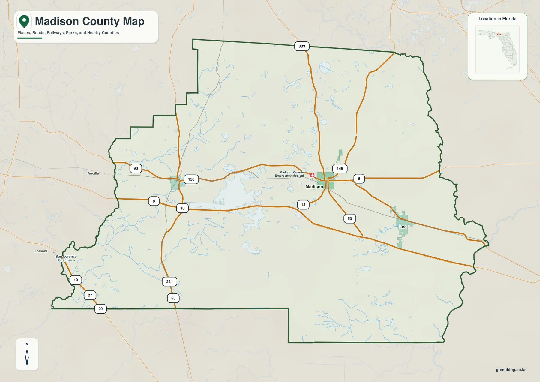
The county outline adds useful context to those roads. Jefferson County and Taylor County are on the western side, Hamilton County and Suwannee County are to the east, and Lafayette County touches the southwest. The northern boundary reaches the Georgia state line. Parts of the western edge are irregular rather than perfectly straight, reflecting the way local boundaries meet natural features. That is one reason the full county map is better than a simple list of town names when you need to understand where Madison County sits within the wider north Florida region.
Straight-line city connections from Madison
The city-connections map simplifies the county by treating Madison as the hub and comparing it with Greenville and Lee. Greenville is shown to the west and Lee to the east, matching the US 90 arrangement on the county map. The distances printed on this graphic are straight-line distances, not driving distances. They are useful for comparing direction and separation between towns, but they should not be used to estimate a road trip or travel time.
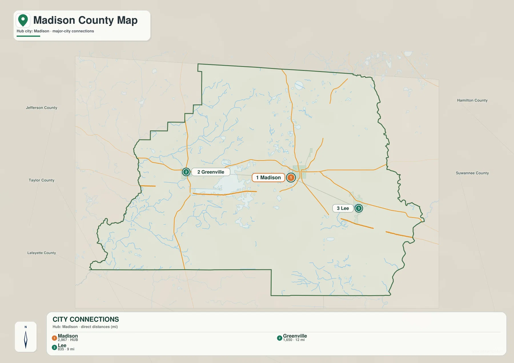
The graphic lists Greenville at about 12 miles from Madison and Lee at about 9 miles. Those numbers help show how compact the main US 90 town sequence is compared with the full size of the county. Actual road mileage can be longer because streets and highways do not follow a perfectly straight line. For a reader preparing a county overview, school handout, or travel reference, this map works best as a quick orientation graphic rather than a navigation tool.
It also highlights how much of Madison County lies outside those three named places. Large sections north and south of the US 90 corridor contain rural roads, small communities, ponds, creeks, farmland, and forested land rather than another dense chain of towns. The city map intentionally leaves that detail out so the relationship among the three principal points is easy to see. Pairing it with the county map restores the surrounding roads and boundaries when more context is needed.
Withlacoochee on the east, Aucilla waters on the west
The water map changes the focus from roads to rivers, lakes, ponds, and creeks. The Withlacoochee River is the dominant named river along the eastern side of Madison County, following the boundary for a long distance before continuing south. On the opposite side, the Little Aucilla River appears in the northwest and the Aucilla River reaches the southwest edge. Instead of one river dividing the middle of the county, Madison County has major water features on both outer sides with smaller water bodies scattered across the interior.
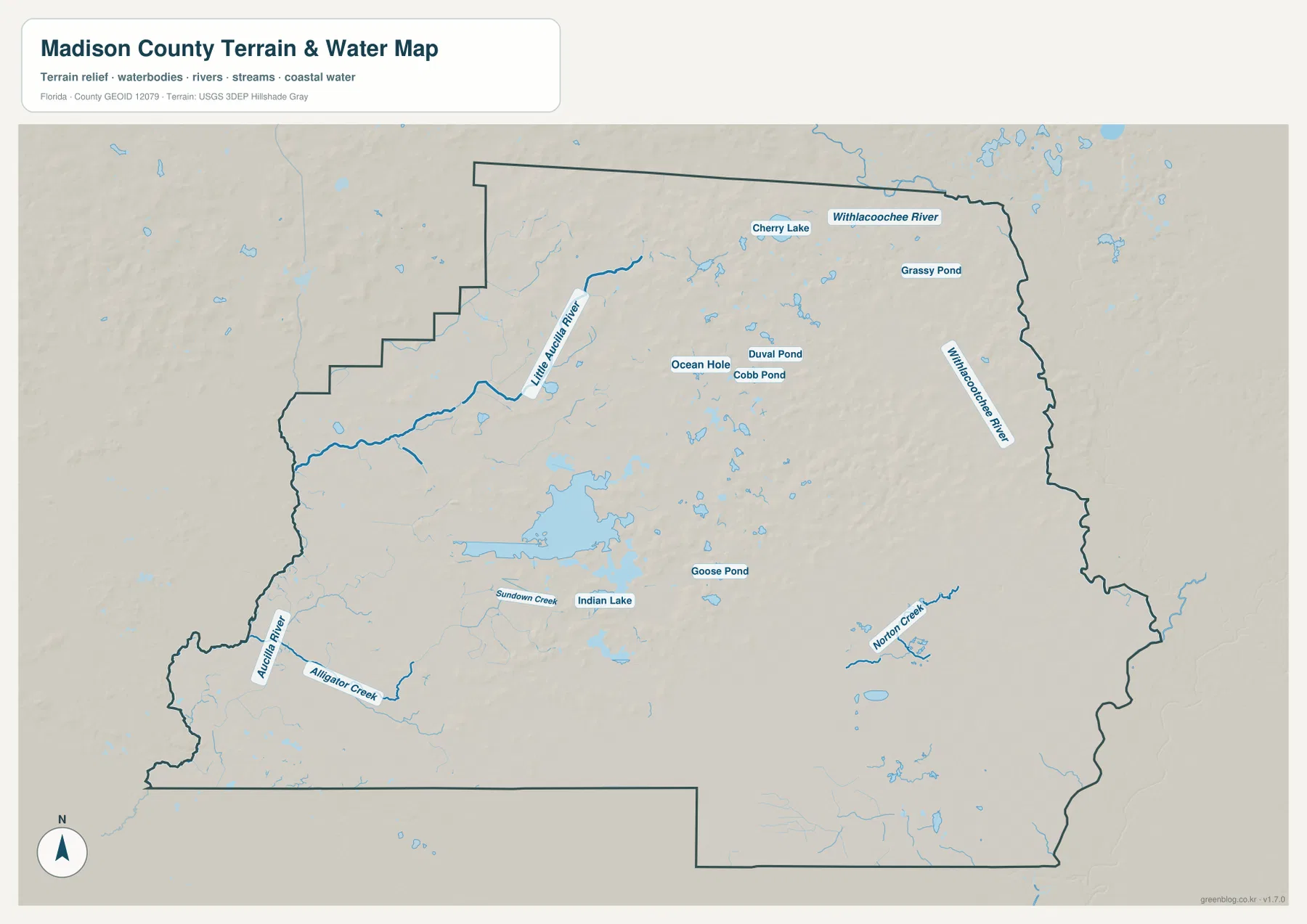
Cherry Lake and Grassy Pond are labeled in the northern part of the county. Near the central area, Ocean Pond, Duval Pond, and Cobb Pond appear among a larger scatter of small water bodies. Farther south, Indian Lake and Goose Pond are visible, along with creeks such as Sundown Creek and Norton Creek. Alligator Creek is shown near the Aucilla River in the southwest. These labels make the water map especially helpful when a place name is tied to a lake, pond, or creek rather than to a town or highway.
This map should be read as a geographic water reference, not as a flood-zone, parcel, legal-boundary, or boating-navigation product. It is well suited to questions such as which side of the county a river is on, where Cherry Lake sits relative to Madison, or whether a named creek is in the eastern or western part of the county. More specialized decisions about flooding, property boundaries, or safe navigation require the appropriate official datasets and current local guidance.
Choosing the map that answers the question fastest
Use the county map when you need the broadest context. It places Madison, Greenville, and Lee inside the county outline, shows the larger road network, and makes the neighboring counties easier to understand. It is the most useful starting point for a general county overview or for locating US 90 and I-10 before looking at more specific details. Because it includes both roads and a light background of water features, it also helps connect the town pattern with the physical shape of the county.
The city-connections map is better when the question is simply how Greenville and Lee relate to Madison. Its reduced detail makes direction and straight-line distance easy to compare. The water map is the better choice for the Withlacoochee River, the Aucilla system, Cherry Lake, and the county’s many smaller ponds and creeks. Switching among the three maps is more efficient than trying to force every kind of information into one crowded image.
For printing or offline use, the download below contains the same county, city-connections, and water maps as high-resolution JPG files. The A3 dimensions provide more room for labels than the web previews, so the files are useful when a larger printed page or a saved local copy is preferred.
Frequently Asked Questions
Are the 9-mile and 12-mile labels on the city map driving distances?
No. They are straight-line distances from Madison to Lee and Greenville. Road mileage can be longer because the actual route follows streets and highways rather than a direct line, so use a current navigation service when you need driving distance or travel time.
Which river is most visible along the eastern side of Madison County?
The Withlacoochee River is the major named river shown along the eastern side of the county. The Little Aucilla and Aucilla rivers appear on the western and southwestern sides, so the water map makes it easy to distinguish the two river systems.
What is included in the downloadable ZIP?
The archive contains three high-resolution A3 JPG files: the county map, the city-connections map, and the water map. They match the map subjects shown in the article but are provided at a larger size for printing and offline reference.
Map File Information
The ZIP contains the three Madison County maps shown on this page as high-resolution A3 JPG files.
- Printable Size: A3, 3638 × 2572 px
- File Type: ZIP containing 3 JPG files
Related Maps
- Arcadia Roads and Peace River | DeSoto County Florida Map
- Baker County Florida Map
- Blountstown, SR 20, and the Apalachicola River | Calhoun County Florida Map
Sources and references
- U.S. Census Bureau — Madison County QuickFacts
- Florida Department of Transportation — County General Highway Maps
- Florida Department of Environmental Protection — North Withlacoochee River Paddling Guide
- Madison County Board of County Commissioners
- Visit Madison — About the Area
Green Map creates custom-edited map images using open geographic data sources such as geoBoundaries, Natural Earth, OpenStreetMap, and government open data. These maps are edited visual materials, not raw data files, and are provided for education, documents, presentations, and graphic reference.