Mecklenburg County North Carolina Map visitors can use this page to locate Charlotte, the northern towns near the lake, the southeastern communities, major roads, county edges, streams, reservoirs, and terrain. Three map views are included in the article: a general county map, a city map, and a terrain-and-water map. The same map set is also available as high-resolution A3 JPG files in one ZIP download, so you can check the web previews first and use the larger originals for printing or close inspection.
Charlotte dominates the center of Mecklenburg County, but the county is much easier to understand when the outer towns and water features are kept in view. Huntersville, Cornelius, and Davidson extend north toward the large lake system, while Matthews and Mint Hill lie southeast and east of Charlotte. Pineville appears near the southern edge. On the western and northwestern sides, irregular shorelines and waterways create a very different map pattern from the dense road network around Charlotte.
Table of Contents
Charlotte is the easiest starting point for the county road map
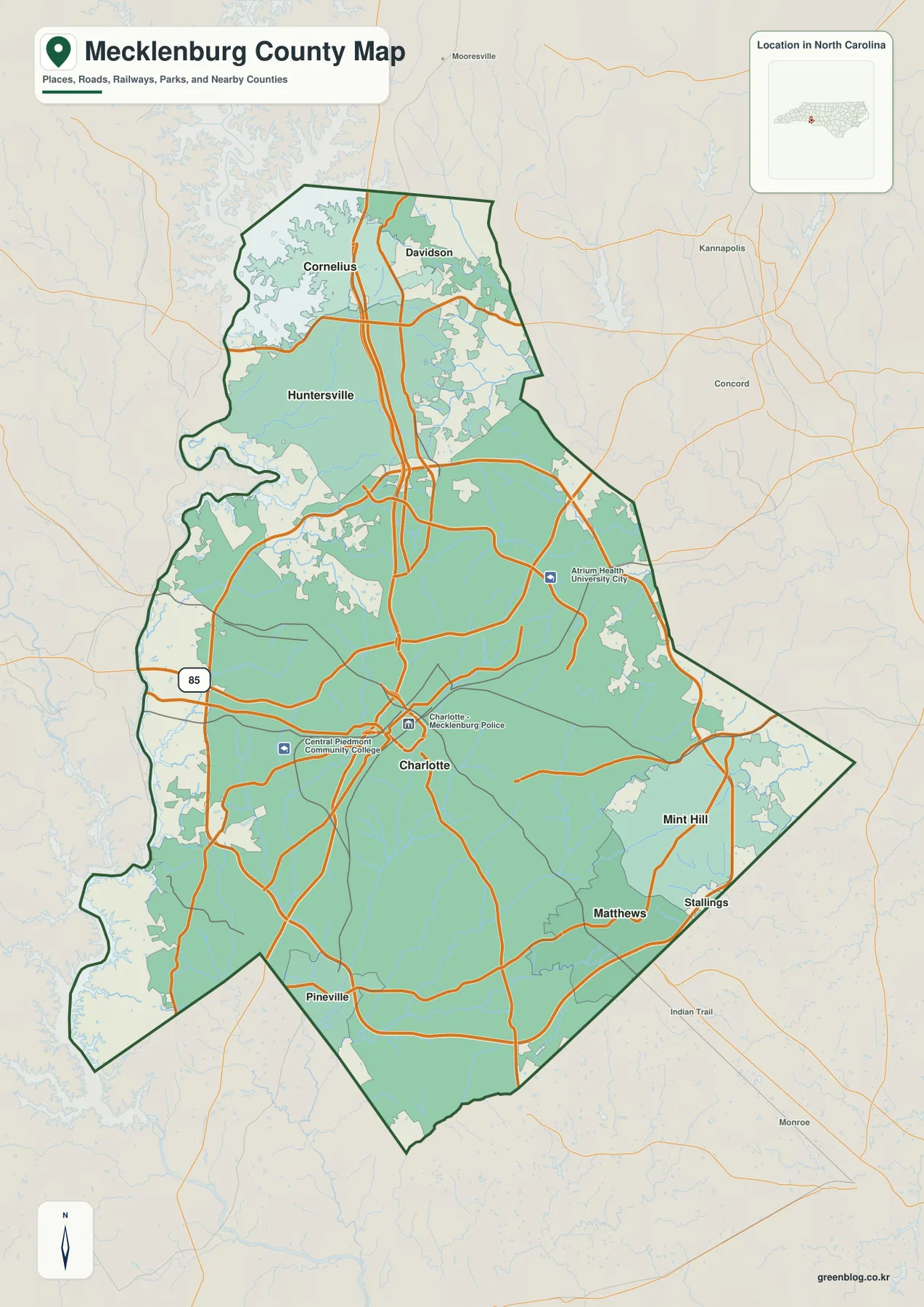
The general county map makes Charlotte the most useful first reference. Major roads converge around the city and continue north toward Huntersville, Cornelius, and Davidson, while other routes fan east and southeast toward Mint Hill and Matthews. Pineville sits south of Charlotte close to the county boundary. Instead of treating Charlotte as the entire county, the map lets you follow these separate directions outward and see where the major communities sit within the county outline.
I-85 is visibly marked on the western side of the map, and several other large road corridors are easy to trace by their width and continuity even where route numbers are not emphasized. A strong north-south route passes through the Charlotte area toward the northern towns, while ring-like and cross-county roads connect the eastern and southern sections. For a visitor trying to orient quickly, the direction of these roads is often more useful than memorizing every local street name.
Places outside Mecklenburg County help with orientation as well. Concord and Kannapolis appear to the east and northeast, Mooresville is north of the county, and Indian Trail and Monroe are southeast. These labels show why Matthews and Mint Hill sit close to the eastern side of the county and why the northern towns are tied to a broader lake-and-suburban area beyond Mecklenburg. The map is therefore useful for both county-scale location and nearby regional context.
Huntersville, Cornelius, and Davidson form a distinct northern group
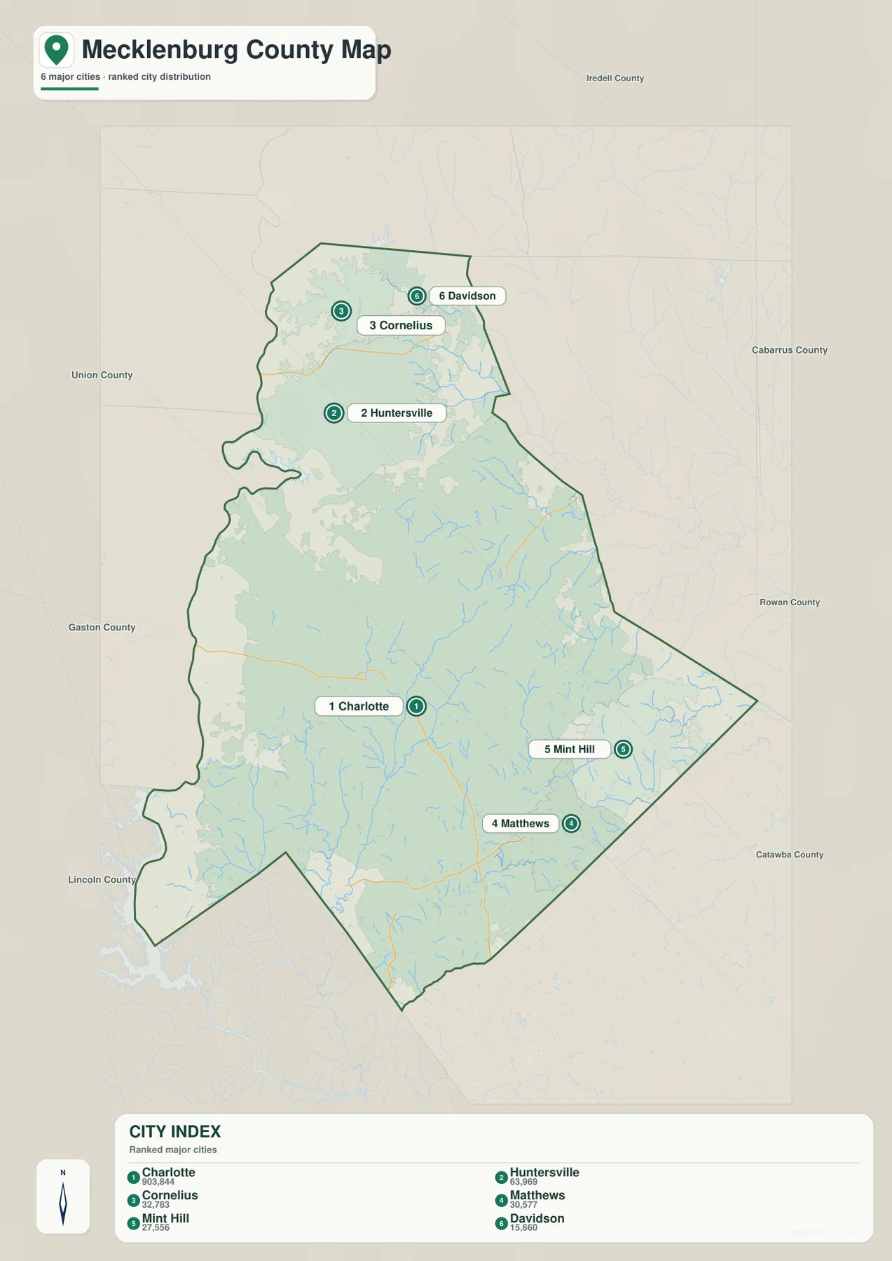
The city map removes much of the road detail and makes the town pattern easier to compare. Charlotte is ranked first and appears in the central part of the county. Huntersville is farther north, with Cornelius and Davidson close to the northern end. The large water area to the northwest gives the northern group a setting that looks very different from central Charlotte. The city map is especially helpful when you want to compare locations without the visual weight of a full road network.
Huntersville occupies a broad position between Charlotte and the two northernmost towns. Cornelius lies closer to the irregular shoreline on the northwest side, while Davidson is just to its east near the county’s northern tip. These differences matter when a general search result simply groups all three places into “north Charlotte.” On the map they are clearly separate communities, and their positions explain why lake access, county boundaries, and routes toward Iredell County become more prominent as you move north.
Matthews and Mint Hill create another useful contrast. Matthews is southeast of Charlotte, while Mint Hill is farther east and slightly north of Matthews. They do not share the same lake-oriented setting as Cornelius and Davidson. Their map position is closer to the eastern county line and the direction of Union and Cabarrus areas. Pineville, visible on the general map, gives one more southern reference and helps separate the southwest side from the Matthews corridor.
Neighboring county labels around the city map include Iredell, Cabarrus, Rowan, Gaston, Lincoln, and Union. They are not shown as a detailed county-boundary study, but they are valuable orientation markers. Cornelius and Davidson sit near the north, Matthews and Mint Hill approach the eastern and southeastern sides, and Charlotte occupies the large central area between them. That layout is a practical way to understand Mecklenburg before moving to neighborhood-level maps.
Creeks and reservoirs become much clearer when the roads are removed
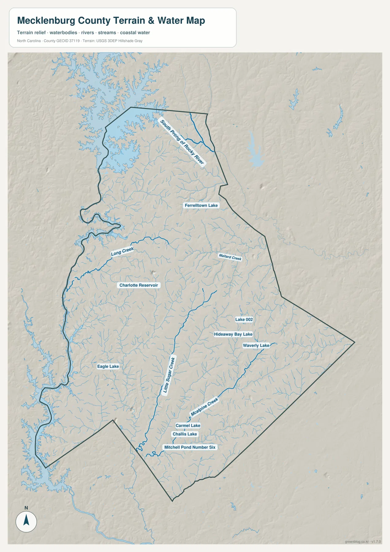
The terrain-and-water map changes the emphasis completely. Roads are no longer the main feature, so the network of streams and small water bodies is easier to follow. South Prong of Rocky River is labeled in the north, while Long Creek crosses the west-central part of the county and Mallard Creek appears farther east. The map also shows the complex water edge along the northwest and west sides, where the county outline bends around large connected water areas.
South of central Charlotte, Little Sugar Creek runs toward the lower part of the county. McAlpine Creek follows a separate route farther east. Seeing both on the same map is useful because they demonstrate that south Charlotte and the Matthews side are drained by multiple creek systems rather than one single watercourse. Small tributaries branch from these named streams throughout the map, so the water network remains visible even in heavily developed parts of the county.
Several lakes and reservoirs are labeled individually. Charlotte Reservoir is west of the center, Eagle Lake appears in the southwest, and Ferrelltown Lake is north of central Mecklenburg. Carmel Lake, Challis Lake, Hideaway Bay Lake, Waverly Lake, and other smaller water bodies are also marked. These names are useful for local orientation because many of them would be difficult to notice on the general county map, where roads and place labels naturally receive more attention.
The shaded terrain is gentle compared with the mountain counties of western North Carolina, but it is not featureless. Broad low ridges and shallow valleys repeat across Mecklenburg, and the stream network follows those subtle changes in elevation. Around Charlotte, development can make the landscape look almost uniform on a road map, yet the water map shows that creeks still cut across the metropolitan area. Comparing the general and water maps gives a more complete picture of how the built environment sits on the underlying terrain.
The western water edge and eastern suburbs create different map patterns
One of the clearest county-scale differences is visible along the west. The boundary bends repeatedly around water, and the terrain-and-water map confirms that the same side is closely tied to the Catawba water system. The northwestern lake area is especially irregular, with long inlets and shoreline fingers. This creates a natural edge that looks very different from the eastern side, where roads and suburban development continue toward neighboring communities with fewer large water interruptions.
The northern towns also reflect this difference. Cornelius and Huntersville lie close to the large lake environment, while Davidson is near the northern county tip. Charlotte, by contrast, is defined more strongly by its dense road connections and broad metropolitan footprint. Moving from central Charlotte northward therefore changes the map from a road-dominated urban pattern to a mix of towns, shoreline, and water. That transition is easy to miss if only a downtown map is used.
To the southeast, Matthews and Mint Hill sit in a more continuous suburban landscape. The water map still shows many creeks, especially McAlpine Creek and smaller tributaries, but the county edge is not shaped by a large lake in the same way as the west and northwest. Pineville adds a southern reference near the lower county boundary. Taken together, these areas show why Mecklenburg is best understood as several geographic settings surrounding Charlotte rather than one uniform metropolitan surface.
Choose the map by the question you need to answer
Start with the general county map if you need an overall reference for Charlotte, the outer towns, major roads, county shape, and nearby cities. It is the most efficient view for checking whether Huntersville is north of Charlotte, where Matthews sits relative to the southeast boundary, or how Pineville connects to the southern part of the county. The general map also gives enough water background to show that the west and northwest are physically different from the central road network.
Use the city map when the main task is comparing the positions of Charlotte, Huntersville, Cornelius, Davidson, Matthews, and Mint Hill. The simplified layout reduces road detail and makes the north-versus-southeast pattern obvious. Use the terrain-and-water map when you need creeks, reservoirs, lakes, or relief. Long Creek, Mallard Creek, Little Sugar Creek, and McAlpine Creek are much easier to locate there than on the other two views.
For printing, classroom use, local reference, or close inspection of labels, the downloadable ZIP provides the same three maps as high-resolution A3 JPG files. The WebP images in the article are optimized for browsing, while the JPG originals preserve a larger working size. You can preview the maps here, decide which one contains the information you need, and then use the ZIP when a larger file is more practical.
Frequently Asked Questions
Which towns are easiest to compare outside Charlotte?
The city map clearly marks Huntersville, Cornelius, Davidson, Matthews, and Mint Hill in addition to Charlotte. The northern three form a group near the lake and county’s northern end, while Matthews and Mint Hill lie southeast and east. Pineville is also shown on the general county map near the southern boundary. Comparing the city map first and then checking the road map makes the directional differences easy to understand.
Where can I find the smaller creeks and reservoirs?
The terrain-and-water map is the best view for that purpose. It labels Long Creek, Mallard Creek, Little Sugar Creek, McAlpine Creek, Charlotte Reservoir, Eagle Lake, Ferrelltown Lake, and several additional small lakes and ponds. The general map gives better road context, so a useful approach is to locate the water feature first and then switch back to the county map to see nearby towns and routes.
What is included in the downloadable ZIP?
The ZIP contains high-resolution A3 JPG files for the general Mecklenburg County map, the city map, and the terrain-and-water map. They match the three map types shown in the article but use larger original files than the web previews. They are suitable for printing, offline reference, personal study, or any situation where the smaller browser images do not show enough detail.
Sources and Reference Data
The article is based first on the maps and validation materials included in this package. The following public sources provide additional county background, boundary data, and hydrography references.
Map File Information
This ZIP contains high-resolution A3 JPG versions of the Mecklenburg County general map, city map, and terrain-and-water map. The larger originals make it easier to inspect Charlotte, the northern towns, roads, streams, lakes, and county boundaries or to print the maps for personal use.
- Included Files: Use only the versions confirmed in the article and supplied images
- File Type: Use the confirmed download contents
- Intended Use: Printing, education, presentations, and map-based projects
Related Maps
Green Map creates custom-edited map images using open geographic data sources such as geoBoundaries, Natural Earth, OpenStreetMap, and government open data.
These maps are edited visual materials, not raw data files, and are provided for education, documents, presentations, and graphic reference.