Mitchell County North Carolina Map visitors can use this page to compare Bakersville and Spruce Pine, trace the principal numbered roads, and follow North Toe River with the smaller mountain streams shown on the terrain map. The article includes a general county map, a city-location map, and a terrain-and-water map, and the same map set is available as high-resolution A3 JPG files in one ZIP download. The web previews are useful for quick orientation, while the downloadable originals are better when you need larger labels for printing, study, or offline reference.
Mitchell County sits in the northwestern Blue Ridge mountain region of North Carolina. Bakersville is the county seat, but the maps make it clear that Spruce Pine is another important location reference in the southern part of the county. Steep ridges, narrow valleys, winding roads, and many named creeks create a landscape where straight-line distance is less informative than the route a road or stream actually follows through the mountains.
Table of Contents
Bakersville and Spruce Pine give the county two useful orientation points
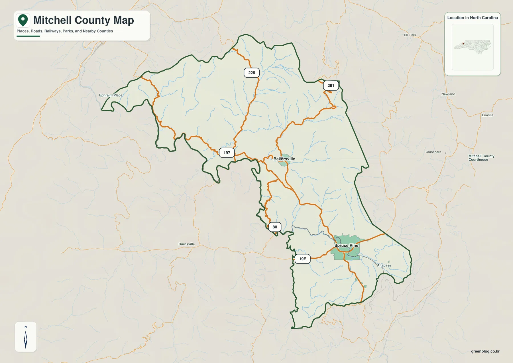
On the general county map, Bakersville appears north of the county’s middle, while Spruce Pine is farther south. The two towns do not simply sit along one straight corridor. Roads divide around mountain slopes and creek valleys, so each town anchors a different part of the map. Around Bakersville, routes 197, 226, and 261 provide useful directional references, while the Spruce Pine area is closely associated with 19E and the southern road network.
Bakersville works well as the administrative starting point because it is the county seat and lies near several roads that spread into the northern and western mountains. Spruce Pine is more useful when the focus shifts toward the southern part of Mitchell County. Keeping both towns in view prevents the county from being reduced to one center and makes it easier to understand why travel routes, stream valleys, and settlement locations change as you move from north to south.
The map also labels places beyond the county boundary, including Burnsville, Newland, Crossnore, and Linville. These are best used as outside orientation markers rather than as Mitchell County destinations. Burnsville helps establish the western and southwestern direction, while Newland and Crossnore make the eastern side easier to place. The surrounding names reinforce how Mitchell County fits into a broader group of mountain communities.
Routes 197, 226, and 261 help organize the northern mountain road pattern
Route 226 runs through the northern half of the county, while 261 appears near the northeastern side and 197 provides an important reference west of Bakersville. Farther south, Route 80 and 19E become easier to see near the narrower central and southern portions of the county. Rather than memorizing each number in isolation, it is more useful to notice which roads connect the Bakersville area to the northern mountains and which roads lead toward Spruce Pine and the lower part of the map.
The road lines bend repeatedly because Mitchell County is not a flat grid. They follow valleys, cross drainage divides where possible, and turn around steep terrain. That pattern becomes much easier to understand after comparing the general county map with the shaded terrain-and-water map. A road that appears indirect on the first map often follows a clear valley on the second.
Near Spruce Pine, 19E provides a strong east-west reference and helps separate the southern travel pattern from the road network around Bakersville. Route 80 appears in the narrower central-southern section, while the northern routes spread into a broader mountain area. This difference is useful when planning a route or simply locating a place, because the best reference road depends on which half of the county you are using.
The city map makes the Bakersville–Spruce Pine separation immediately clear
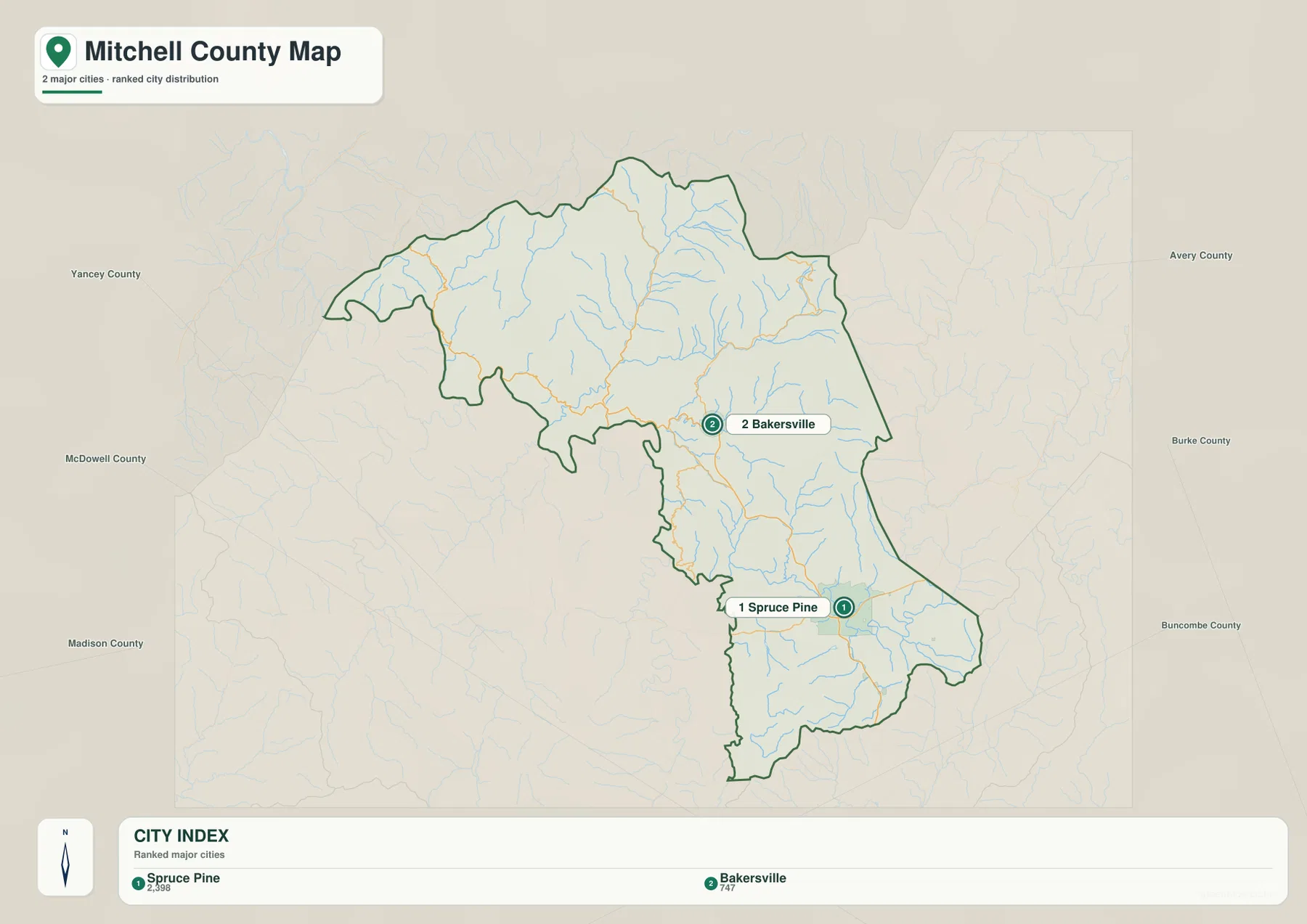
The city map removes most of the road detail and focuses on the two ranked major cities. Spruce Pine is marked as number 1 and Bakersville as number 2. The ranking itself is less important than their relative position: Spruce Pine lies in the southern part of the county, while Bakersville sits farther north. With fewer visual elements, the map makes that north-south separation much easier to see.
County names around the frame include Yancey, McDowell, Madison, Avery, Burke, and Buncombe. They provide broad regional orientation rather than a detailed study of every shared boundary. Yancey on the west and Avery on the east are especially useful for locating Mitchell County within the western North Carolina mountains, while the other labels show the larger geographic setting surrounding the map.
A practical way to use the three views is to begin with the city map, establish where Bakersville and Spruce Pine sit, and then switch to the general map to see the roads between them. The terrain-and-water map can then explain the valleys and streams around the same locations. This sequence separates place, transportation, and physical geography instead of forcing all three kinds of information into one crowded view.
North Toe River connects a dense network of named mountain creeks
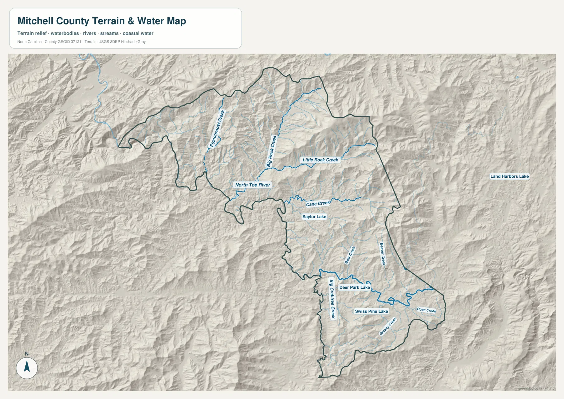
North Toe River is one of the clearest physical references on the terrain-and-water map. It appears in the west-central part of Mitchell County and forms part of a wider drainage network that includes Pigeonroost Creek, Big Rock Creek, Little Rock Creek, and Cane Creek. The map is especially useful because it shows that the river system is not one isolated blue line; numerous smaller valleys feed into it from different directions.
Pigeonroost Creek descends through the northwestern interior, while Big Rock Creek and Little Rock Creek occupy separate valleys farther east. Cane Creek crosses the central area and is easy to recognize because of its long named segment, with Saylor Lake shown nearby. These features are much more visible on the water map than on the general county map, where roads and town labels naturally compete for attention.
In the southern half, Bear Creek, Beaver Creek, Big Crabtree Creek, Grassy Creek, and Rose Creek add another layer of detail. Deer Park Lake and Swiss Pine Lake are also labeled near the southern drainage network. The number of named creeks is a reminder that Spruce Pine and the southern part of Mitchell County occupy a landscape cut by many small mountain valleys rather than one broad, simple river plain.
Land Harbors Lake is labeled outside the county to the east, so the county boundary should be checked before treating every visible water name as an internal Mitchell County feature. This is one reason the dark county outline on the terrain map matters. Following the boundary first and then reading stream and lake labels helps separate internal features from useful outside reference points.
Closely spaced ridges and narrow valleys explain the winding travel pattern
The hillshade makes Mitchell County’s mountain relief impossible to miss. Ridges and hollows repeat across nearly the entire map, with particularly strong relief in the northern and western areas. Streams occupy the lower lines between ridges, and many roads on the general map follow those same broad valley directions. The older package notes also identify the Roan Mountain high country and the North Toe River valley as contrasting physical references, a difference that fits the relief visible in the map.
Because of this terrain, two points that look close on a county outline may require a longer road trip than expected. Roads usually take advantage of valleys and lower passes rather than crossing every ridge directly. Comparing the road map and terrain map is therefore more informative than relying on straight-line distance, especially when moving between Bakersville, Spruce Pine, and places near the county edges.
The terrain also helps explain why Bakersville and Spruce Pine work as separate reference points. They occupy different parts of a county divided by many ridges and drainage valleys, so each town is connected to a somewhat different set of roads and local watercourses. The county boundary alone cannot show that relationship; it becomes clear only after the city, road, and terrain maps are considered together.
Frequently Asked Questions
Why is North Toe River a stronger physical anchor than a simple place-name list?
North Toe River is used as a physical anchor rather than a decorative label. Read alongside Bakersville, Spruce Pine, and Penland, it helps separate settlement geography from the county’s natural structure.
What geographic contrast appears when Spruce Pine and Bakersville are read together?
Bakersville carries the county-seat role, while Spruce Pine is useful as a separate settlement or functional-area reference. Keeping both visible makes the county less dependent on a single administrative center.
Why should Bakersville and Spruce Pine be used as separate map references?
Bakersville is the county seat and a useful reference for the central and northern road network, while Spruce Pine gives a clearer reference for the southern part of the county and the 19E corridor. The city map shows their separation first, and the general map then reveals the different roads and stream valleys connected to each place.
Which named streams can I find besides North Toe River?
The terrain-and-water map labels Pigeonroost Creek, Big Rock Creek, Little Rock Creek, Cane Creek, Bear Creek, Beaver Creek, Big Crabtree Creek, Grassy Creek, and Rose Creek. It also shows small water bodies such as Saylor Lake, Deer Park Lake, and Swiss Pine Lake, making it the most useful view for detailed water-feature searches.
What files are included in the downloadable ZIP?
The ZIP includes high-resolution A3 JPG files for the general Mitchell County map, the city map, and the terrain-and-water map. They match the map types shown on the page but use larger originals than the browser previews, which makes them more suitable for printing, offline reference, or enlarged viewing.
Sources and Reference Data
This article is based first on the maps, package notes, and validation material supplied for this Mitchell County rewrite. The following public sources are included in the package as additional county, boundary, and hydrography references.
Map File Information
Download the map files associated with this page for reference, printing, and compatible visual projects.
- Included Files: Use only the versions confirmed in the article and supplied images
- File Type: Use the confirmed download contents
- Intended Use: Printing, education, presentations, and map-based projects
Related Maps
Green Map creates custom-edited map images using open geographic data sources such as geoBoundaries, Natural Earth, OpenStreetMap, and government open data.
These maps are edited visual materials, not raw data files, and are provided for education, documents, presentations, and graphic reference.