Download the high-resolution A3 JPG ZIP for this Hickman County Tennessee Map directly from the page; it contains the county, city, water, and elevation maps shown below. Centerville is the single ranked city and the central road reference, while Lyles, Wrigley, and Bon Aqua Junction appear farther northeast on the base map. Duck River makes broad bends across the middle of the county, Piney River joins from the north, and higher rolling terrain rises away from those river valleys.
Hickman County is easiest to understand by following the Duck River first and then locating Centerville beside the central road network. The western half is shaped by long river bends and lower valleys. The northeast contains Lyles and Wrigley among more closely spaced ridges and creeks, while the southern half is cut by Little Piney Creek, Big Swan Creek, and other drainage corridors. The elevation layer confirms that these stream valleys are distinctly lower than the surrounding hills.
Table of Contents
Centerville anchors the county, while Lyles and Wrigley define the northeast
The city map ranks Centerville at 3,535 residents and does not list another major ranked city inside Hickman County. That makes the city layer simple: Centerville is the main internal reference, and the surrounding county names provide broader orientation. Dickson County appears to the north, Humphreys and Perry counties to the west, Lewis County to the southwest, and Maury and Williamson counties to the east.
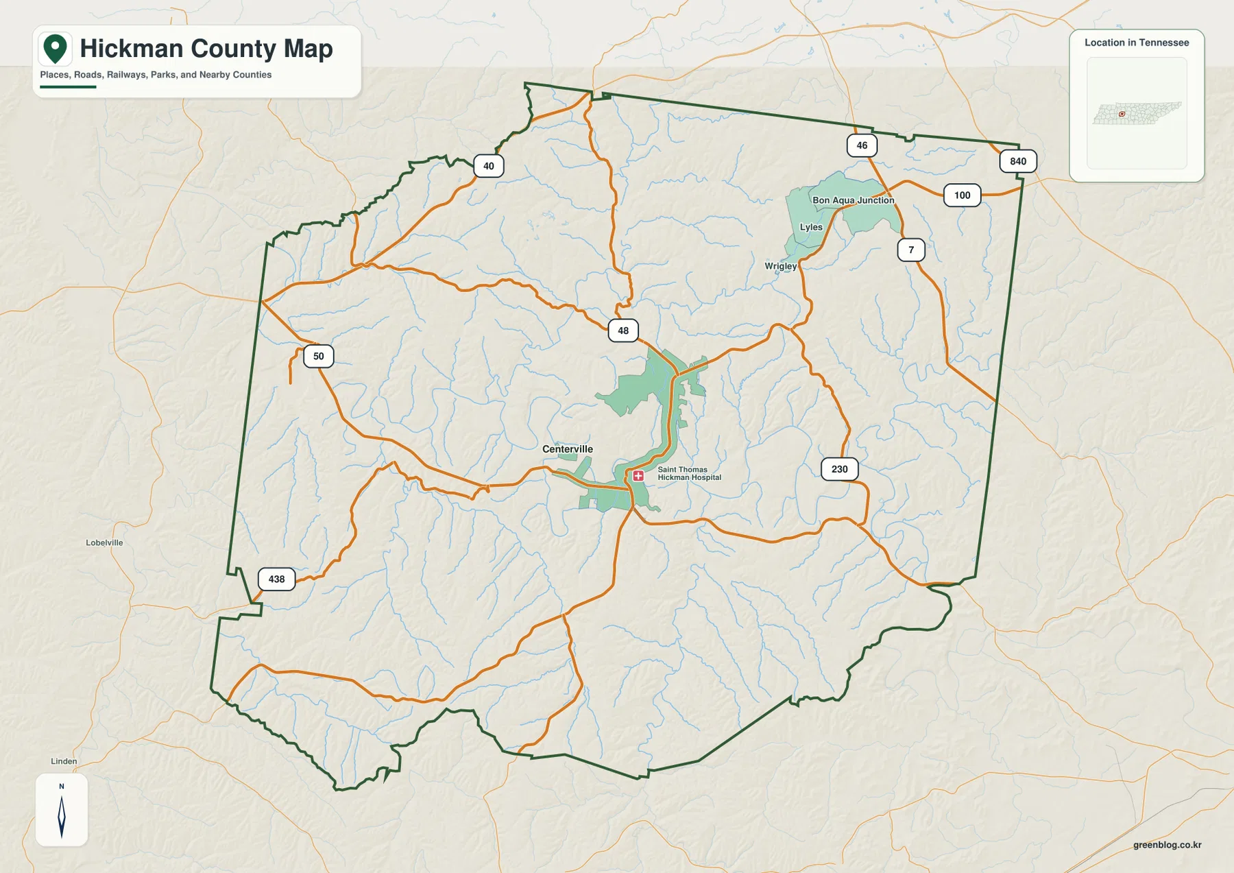
The base map adds local detail that the ranked-city layer intentionally leaves out. Lyles and Wrigley are labeled in the northeastern interior, with Bon Aqua Junction farther north. Saint Thomas Hickman Hospital is marked near Centerville, helping locate the central road-and-service area. These labels show that a one-city ranking does not mean the rest of the county is empty; the more detailed map simply uses a different set of place references.
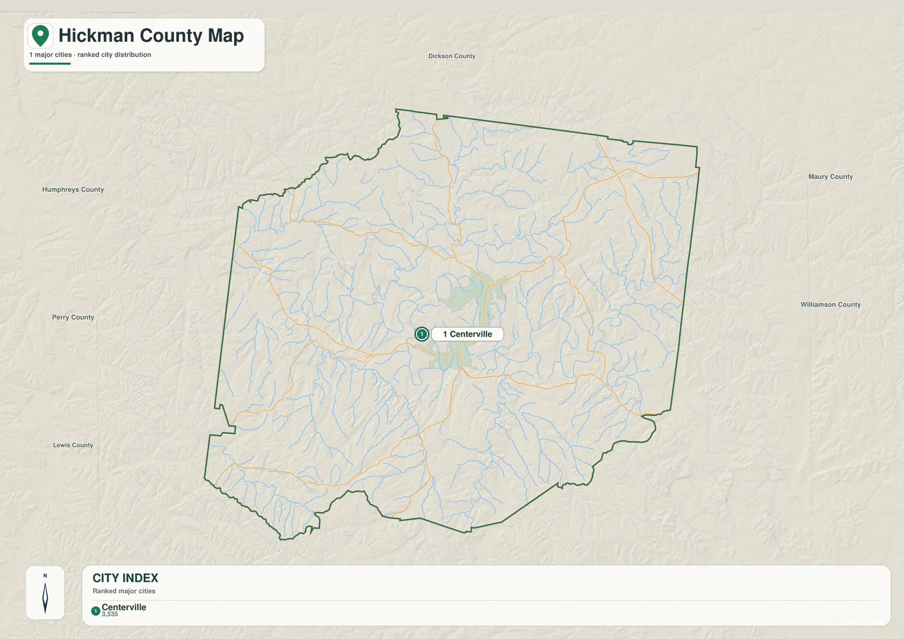
For local orientation, Centerville works best as the reset point. From there, the northeastern labels identify the Lyles–Wrigley side, while the western and southern edges are better read with roads and river valleys. This is more useful than forcing every small community into the city ranking because the base map already provides the local detail needed for those areas.
Routes 48, 50, and 100 separate the main approaches to Centerville
Route 48 is one of the clearest road references on the county map, descending toward Centerville from the north and continuing through the central area. Route 50 crosses the western side, and Route 438 appears near the southwestern boundary. Route 40 provides another northern reference before the road network narrows into the rolling interior.
The northeastern side uses a different set of markers. Routes 100 and 7 are visible near Lyles, Wrigley, and Bon Aqua Junction, while Route 46 and the 840 corridor appear close to the northeastern edge. Route 230 bends through the southeastern interior. Instead of treating all of these numbers equally, it is faster to start with Centerville and choose the route that matches the side of the county being studied.
The bends in the road network make more sense when the rivers and terrain are considered. West of Centerville, roads must work around large Duck River curves. In the northeast, shorter creeks repeatedly cut the ridges and create lower passages. Road lines therefore follow available valleys and crossings rather than a regular grid, especially away from the central town.
Duck River bends across the center while Piney River and smaller creeks cut the hills
Duck River is the strongest water feature on the supplied map. It enters from the western side, forms a series of broad bends through the middle of the county, and continues eastward past the central area. Those curves create a wide low corridor that contrasts sharply with the short ridges rising on both sides of the river.
Piney River descends from the north-central county and joins the Duck River system. Big Spring Creek and Bear Creek feed the northern drainage, while Mill Creek occupies a separate valley to the east. Lick Creek extends through the northeastern hills. Together, these streams explain why the Lyles–Wrigley side is broken into many small valleys rather than one broad open slope.
South of Duck River, Beaverdam Creek and Little Piney Creek follow long low corridors. Big Swan Creek and Blue Buck Creek drain farther south, while Cane Creek and Sugar Creek provide references near the outer western and southwestern portions. Chrystal Lake and Spring Lake are small named waters near the upper Piney drainage and help locate that north-central area.
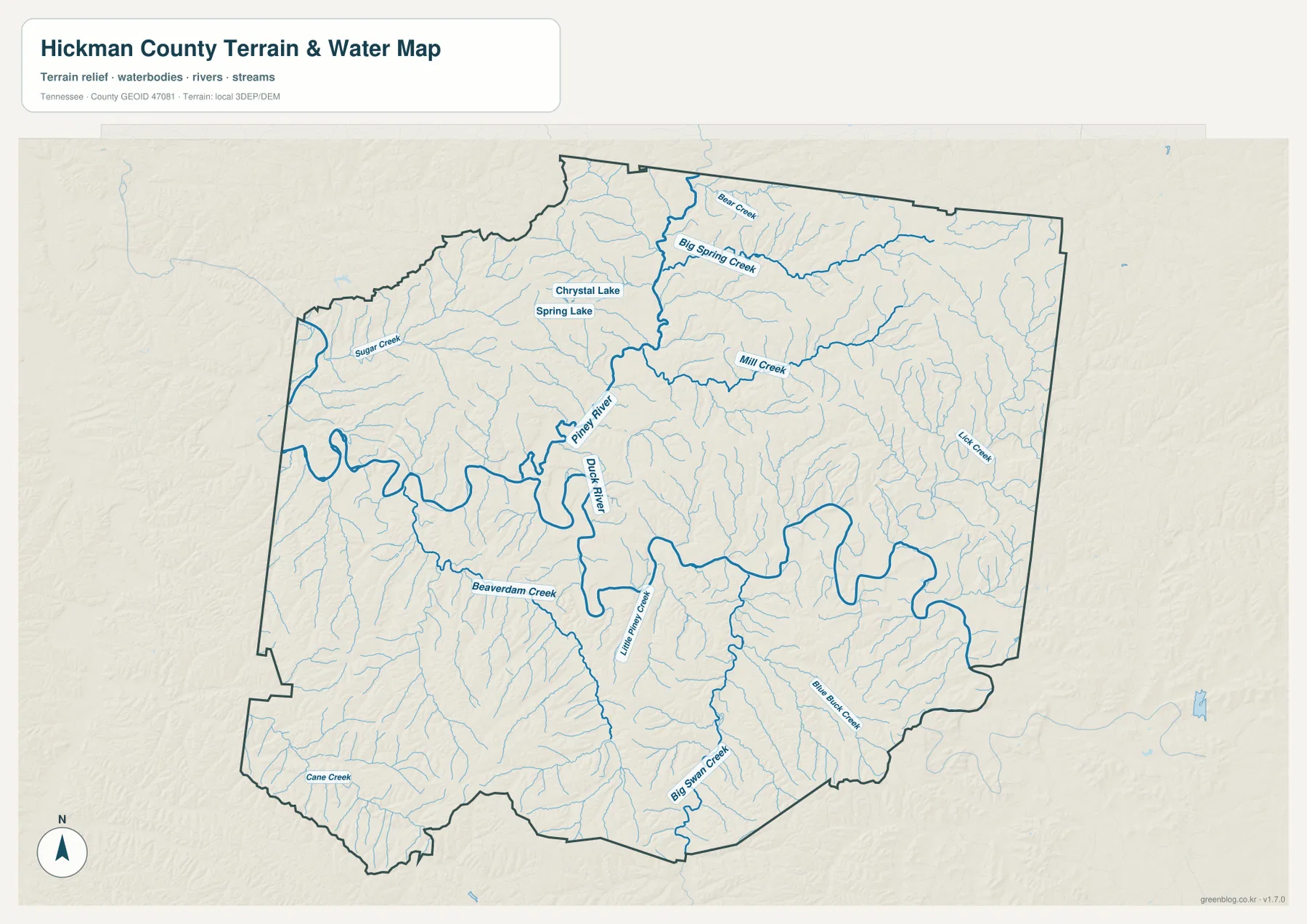
This layer is intended to show where the rivers, creeks, and small lakes sit within Hickman County. It should not be used by itself to judge current water level, a safe crossing, flood conditions, or boating access. For this article, its main value is the connection between the Duck River valley, the Piney drainage, Centerville, and the roads that use lower ground between the hills.
A 115–298 m range separates the Duck River floor from northeastern and southern hills
The elevation map shows an actual range of about 115 to 298 meters, with a mean near 210 meters. The lowest green terrain follows Duck River from west to east and also appears along Piney River and the larger tributary valleys. Away from those channels, the surface rises into short ridges, with broader tan and brown areas in the northeast and south.
The northeastern quarter is especially dissected. Lick Creek and Mill Creek occupy low green corridors, while narrow ridges rise between the branches. That terrain matches the winding road pattern around Lyles and Wrigley. Even where two places appear close on the base map, a ridge or creek valley can force the connecting road to take a less direct path.
South of Duck River, Beaverdam Creek, Little Piney Creek, and Big Swan Creek cut another dense set of valleys into the uplands. The western river bends create wider low surfaces, but those lowlands are bordered quickly by rolling ground. Hickman County is not a high mountain county, yet more than 180 meters separate the lowest and highest mapped elevations, enough to make the river floor and uplands easy to distinguish.
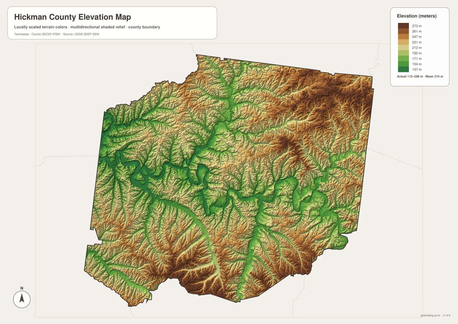
The elevation surface is meant for county-scale comparison rather than an exact parcel or building elevation. It is particularly useful beside the road map because Routes 48, 50, and 230 can be compared with the lower river and creek passages they use. The color changes also make the climb away from the Duck River corridor easier to recognize than on the plain base map.
Centerville and the Duck River give the county two practical reference lines
The city layer begins with one clear anchor: Centerville. The base map adds Lyles, Wrigley, Bon Aqua Junction, and the numbered road approaches. The water map supplies the second major reference, Duck River, whose bends divide the western and central interior. Piney River and the smaller tributaries then explain the local valleys within the surrounding hills.
Looking west from Centerville brings Route 50 and the large Duck River bends into focus. Looking northeast shifts attention to Lyles, Route 100, Lick Creek, and more tightly packed ridges. To the south, Big Swan Creek and Little Piney Creek cut long valleys through higher ground. Each direction has a different combination of roads, water, and relief, so the maps are most useful when those features are read together.
Use the city map when the main question is Centerville and county orientation. The base map is better for local place names and routes, the water map is the strongest choice for Duck River and Piney River, and the elevation layer shows why the river corridors are lower than the northeastern and southern hills.
The browser previews are sized for quick reading, while the JPG originals give more room for printed notes and close inspection. A road-focused copy can keep Centerville and the relevant route visible without adding every creek label. For river study, the water image gives the Duck River bends and tributary names more space, and the elevation image works best in color when the low valleys need to stand out from the hills.
The archive below packages the A3 JPG originals used on this page: county, city, water, and elevation. They are useful when the web images are too small for classroom comparison, a presentation, route annotation, or an offline reference centered on Centerville and the Duck River landscape.
Frequently Asked Questions
Why does the city layer rank only Centerville?
The supplied city map ranks Centerville at 3,535 and does not list another major ranked city inside the county. Lyles, Wrigley, and Bon Aqua Junction still appear on the base county map, so the ranked-city layer should not be treated as a complete list of every place label.
What is the main terrain difference between Duck River and the surrounding hills?
The elevation map shows about 115–298 meters. Duck River and Piney River occupy the lowest green corridors, while northeastern and southern Hickman County rises into tan and brown ridges that sit well above the river valleys.
Sources and reference data
County history and local reference material are available from the Tennessee State Library and Archives Hickman County fact sheet. Road placement can be compared with the Tennessee Department of Transportation Hickman County reference, and county boundaries can be checked against U.S. Census Bureau TIGER/Line.
For additional river and creek reference, see USGS National Hydrography. Elevation data can be compared with the USGS 3D Elevation Program. The descriptions here follow the Centerville, road, water, and 115–298 meter terrain relationships visible in the supplied Hickman County maps.
Map File Information
The ZIP contains A3 high-resolution JPG originals for the Hickman County county, city, water, and elevation maps used above.
- Included Files: County map, city map, water map, elevation map
- File Type: ZIP containing 4 JPG files
Related Maps
Green Map creates custom-edited map images using open geographic data sources such as geoBoundaries, Natural Earth, OpenStreetMap, and government open data. These maps are edited visual materials, not raw data files, and are provided for education, documents, presentations, and graphic reference.