Perry County becomes much easier to read when the maps are anchored to two places: Pinckneyville near the center and Du Quoin in the southeast. Pinckneyville sits where several state routes come together, while Du Quoin lies on the US 51 corridor and connects back toward the center by Route 152. Tamaroa and St. Johns continue north from Du Quoin along the same US 51 line. Cutler and Willisville are farther west, separated from that eastern corridor by a broader landscape of smaller roads, creeks, lakes, and rolling ground. The downloadable set on this page lets you compare those settlement and road relationships with water features and elevation instead of treating each map as an isolated view.
The terrain gives the county a second organizing pattern. Higher, more dissected hills occupy much of the northwest and west-central area, while a long lower corridor follows Beaucoup Creek through the interior. Swanwick Creek approaches from the northwest and Little Beaucoup Creek from the northeast, both feeding toward that central valley. A cluster of small lakes appears in the southwest, while Du Quoin Reservoir and Hesse Creek provide strong reference points in the southeast. The elevation view labels an actual range of about 109 to 183 meters and a mean near 141 meters, so the contrast between western uplands and lower central-southeastern ground is visible at county scale.
Table of Contents
Pinckneyville roads and the separate US 51 corridor
Pinckneyville is the most useful starting point on the general county map. Route 154 runs east-west through the central city, Route 13 approaches from the northwest, and Route 127 continues south from the same area. Route 152 then extends toward Du Quoin, giving the map a clear central-to-southeastern connection. This pattern makes Pinckneyville a practical orientation point even before any city ranking is considered. Perry County’s official history also identifies Pinckneyville as the county seat, which fits the central administrative role suggested by the road layout.
The eastern half works differently. US 51 runs north-south past Tamaroa and St. Johns before reaching Du Quoin, and Route 14 crosses the southern side of Du Quoin. Cutler, by contrast, sits near Route 150 in the west, while Willisville is close to Route 4 in the southwest. The result is not one continuous urban strip across the county. Instead, the map shows a central road junction around Pinckneyville, an eastern chain of communities along US 51, and more widely spaced western settlements.
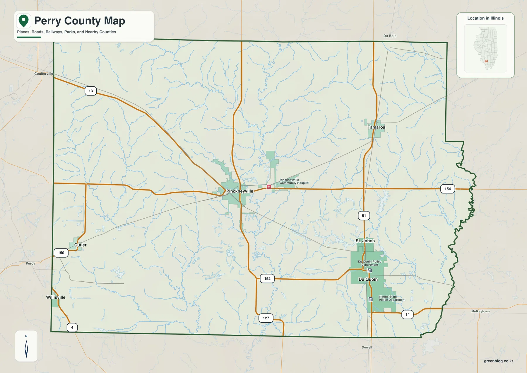
The county boundary adds another visual clue. The western side is comparatively straight through long stretches near Cutler and Willisville, whereas the eastern side steps inward and becomes more irregular through the middle and south. That changing width helps explain why eastern communities appear tucked farther inside the county outline rather than directly against a simple vertical border. The map is intended for geographic orientation, not live navigation, so current traffic, closures, travel times, or turn-by-turn routing should be checked with a dedicated road service.
Two large centers and four much smaller communities
The ranked city map changes the emphasis from roads to settlement size. Its index lists Du Quoin at 5,726, Pinckneyville at 5,018, Tamaroa at 597, Willisville at 477, Cutler at 302, and St. Johns at 184. Those figures are best read as the values printed on this map rather than as a promise of current population at the moment of viewing. The important pattern is the large gap after the top two: Du Quoin and Pinckneyville dominate the ranking, while the other four places are much smaller.
Location matters as much as rank. Pinckneyville occupies the central part of Perry County, while Du Quoin lies well to the southeast. Tamaroa and St. Johns continue north from Du Quoin along US 51, creating a recognizable eastern line of communities. Cutler and Willisville sit close to the western side and are separated from the eastern cluster by a broad interior. Perry County’s official city and village page identifies the same six places, providing civic context for the labels used on the map.
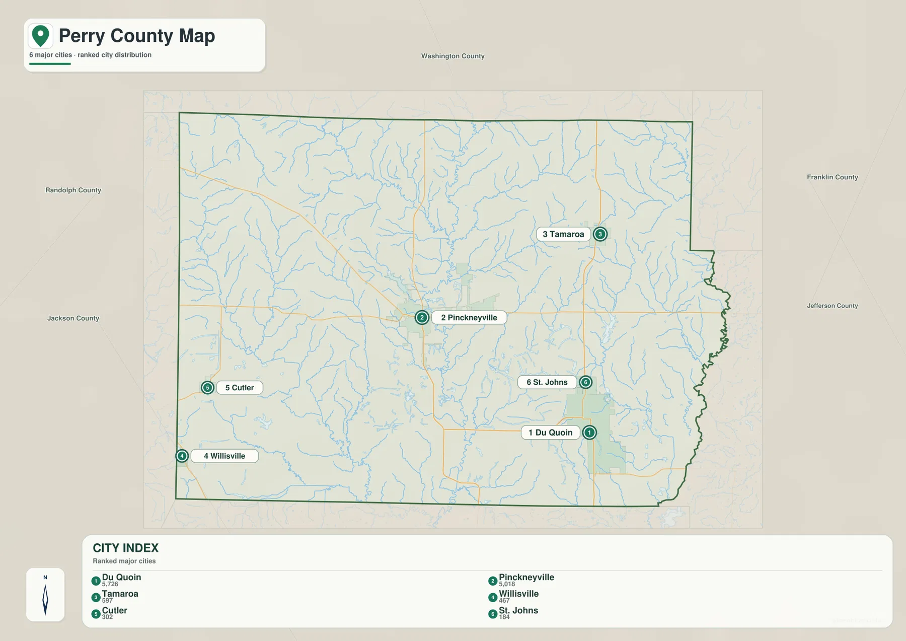
Switching back to the road map explains those positions. The eastern communities share US 51, whereas Pinckneyville is defined by several routes converging from different directions. In the west, settlements are farther apart and the surrounding map shows more small drainage lines and open terrain between them. This makes Perry County easier to understand as three broad reference areas—central Pinckneyville, southeastern Du Quoin and the US 51 communities, and the more dispersed west—rather than as a single settlement corridor.
Beaucoup Creek, northern tributaries, and the southwestern lake cluster
Beaucoup Creek is the strongest water feature for orienting the interior of Perry County. It winds generally south through the central part of the county, with Swanwick Creek joining from the northwest and Little Beaucoup Creek approaching from the northeast. Pinckneyville Reservoir lies to the west of the central stream and gives the county-seat area a second recognizable water landmark. On the elevation map, this same central zone appears as a lower green corridor, so the water and terrain views reinforce each other.
The southwest has a different texture. Clear Lake, Lost Lake, Boulder Lake, and Big Beaver Lake appear relatively close together, surrounded by many smaller drainage lines and rolling relief. The Illinois Department of Natural Resources describes nearby Pyramid State Recreation Area as a landscape of forested hills, lakes, and ponds. That description provides useful regional context for the concentration of small water bodies on this side of the county, although it does not mean that every named lake on the county map lies within one recreation-area boundary.
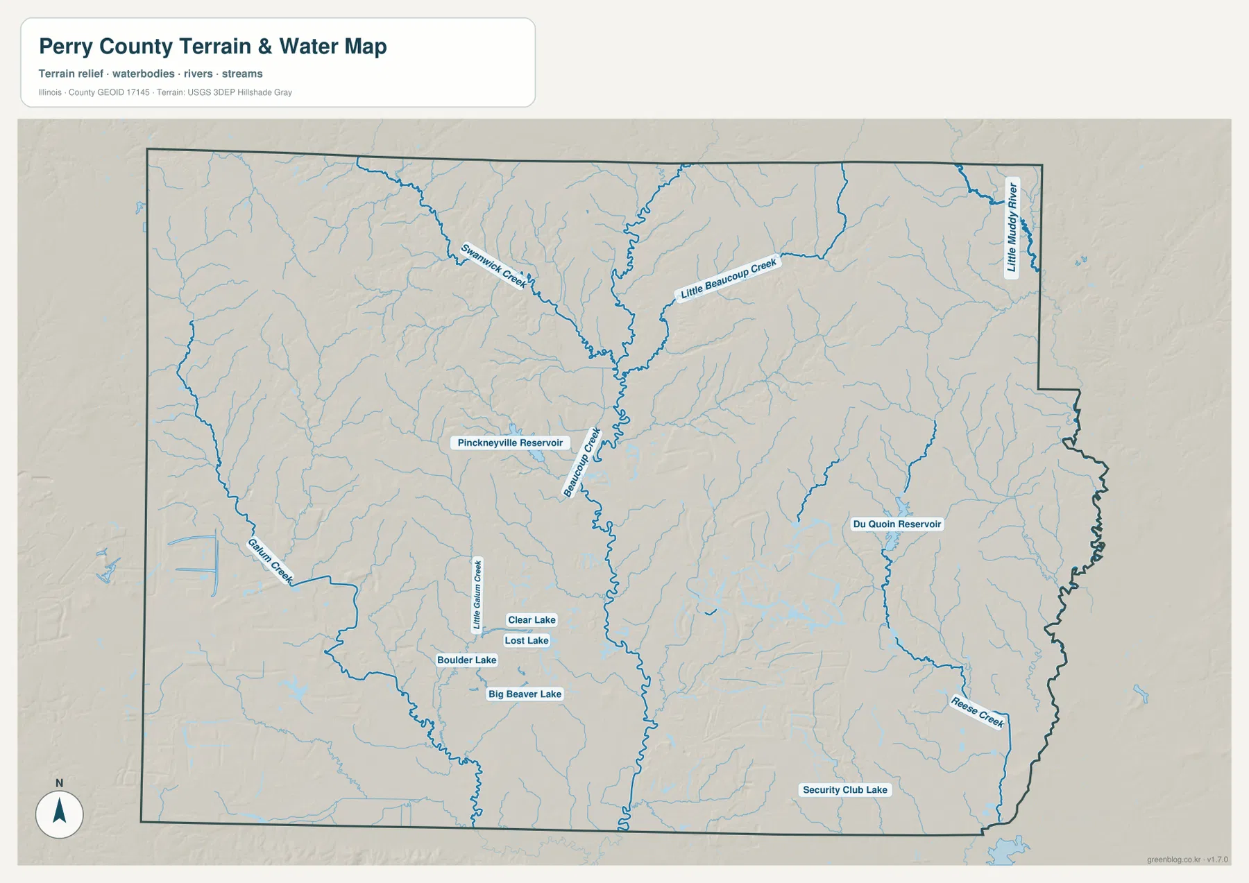
In the southeast, Du Quoin Reservoir lies northeast of the city and Hesse Creek crosses the lower eastern interior. Security Club Lake appears near the southern boundary, and Little Muddy River is visible near the northeastern edge. Galum Creek and Little Galum Creek occupy the western side, giving that part of the county a drainage pattern distinct from the central Beaucoup Creek system. This map is a general water and terrain reference; it should not be treated as a flood-hazard map, a legal water-boundary document, a navigation chart, or a drainage-engineering plan.
Western uplands dropping into a low central valley
The elevation map makes the western-versus-central contrast especially clear. Its legend reports an actual range of roughly 109 to 183 meters, with a mean near 141 meters. The highest brown terrain is concentrated across the northwest and west-central county. Rather than forming one smooth plateau, those uplands are repeatedly cut by narrow valleys, giving the surface a rugged, dissected appearance.
Beaucoup Creek follows the most obvious low corridor. Green terrain extends from the north-central county past the Pinckneyville side and continues south through the interior. Much of the east and southeast is also lower than the western hills, although moderate uplands return in the northeast. The overall pattern is therefore a high western landscape descending toward a central drainage valley and a generally lower southeastern interior.
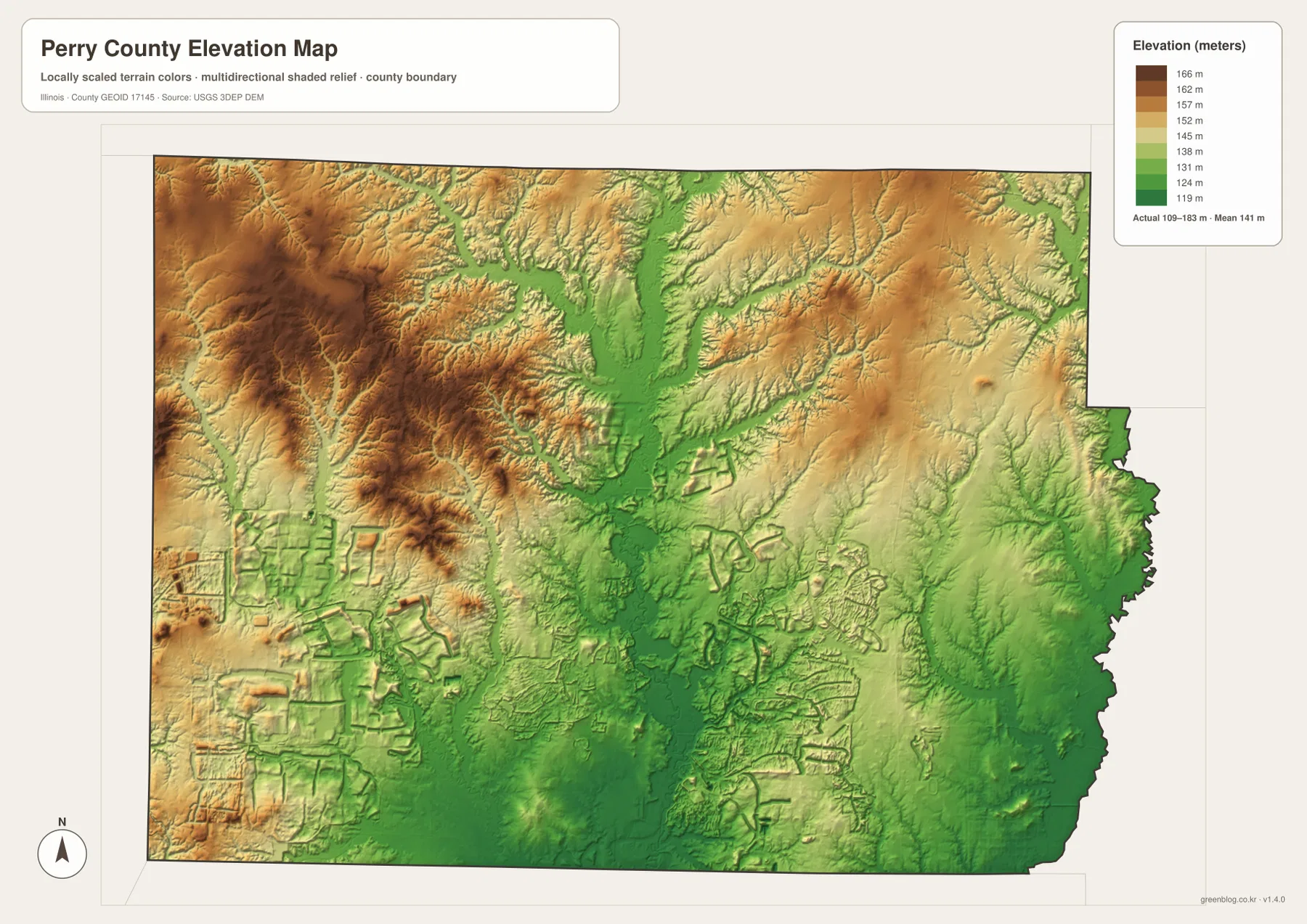
Comparing this view with the water map helps explain why the main streams follow the paths they do. Beaucoup Creek, Swanwick Creek, and Little Beaucoup Creek align with lower green valleys, while smaller tributaries descend through the western uplands. The surface is generalized for county-scale comparison, however, and should not be used as parcel elevation, survey-grade measurement, or engineering design data. Precise site elevation should be checked with detailed USGS data or a professional survey when accuracy matters.
Connect the maps from Pinckneyville to Du Quoin and the western hills
Pinckneyville is a convenient place to connect all four views. The county map shows Routes 154, 13, and 127 converging around the central city. The ranked-city map places it beside Du Quoin as one of the two dominant communities. The water map adds Pinckneyville Reservoir and the nearby Beaucoup Creek system, while the elevation map shows lower terrain developing east and south of the higher western hills. Instead of memorizing four separate map legends, you can follow one place across the set and see how roads, settlements, water, and relief fit together.
Du Quoin provides a contrasting reference. US 51 and Route 152 explain its road position, Du Quoin Reservoir and Hesse Creek give the area nearby water landmarks, and the elevation surface is lower than the prominent western uplands. North of the city, St. Johns and Tamaroa continue along the same US 51 direction. Moving west toward Cutler and Willisville, however, the settlement pattern loosens and the terrain becomes more rolling, with numerous small waterways and lakes becoming more visible.
For a simple printed overview, the general county map is the clearest choice because it combines the boundary, main roads, and principal places. The ranked-city map works better when the goal is to compare the relative prominence and spacing of communities. The water map is useful for locating creeks, reservoirs, and the southwestern lake cluster, while the elevation map adds the reason that the central waterways occupy lower corridors. Because each view answers a different question, using two or more together gives a more complete picture without turning the page into a technical GIS report.
Frequently Asked Questions
What is the easiest way to distinguish Pinckneyville from Du Quoin on the maps?
Look for the central road junction first: Pinckneyville is where Routes 154, 13, and 127 come together. Du Quoin is farther southeast on US 51, with Route 152 approaching from the Pinckneyville side. Tamaroa and St. Johns continue north from Du Quoin along US 51, so the eastern north-south corridor is the quickest visual clue for separating the two major cities.
How does Beaucoup Creek relate to the county’s elevation pattern?
Beaucoup Creek follows the county’s clearest low interior corridor, which appears green on the elevation map. Swanwick Creek and Little Beaucoup Creek also descend toward that lower central area. The northwest and west-central county are much higher and browner, so comparing the water and elevation maps shows how major streams occupy lower valleys between the surrounding uplands.
What is included in the downloadable ZIP?
The ZIP contains four high-resolution JPG files: the general county and road map, ranked city map, terrain and water map, and elevation map. Each file is 3638 × 2572 pixels. Smaller WebP versions are used in the article for quick viewing, while the JPG files are better suited to closer inspection and print. The water and elevation maps are general geographic references rather than flood, legal-boundary, survey, or engineering products.
Map File Information
Download the Perry County county map, ranked city map, terrain and water map, and elevation map together as high-resolution JPG files.
- Printable Size: 3638 × 2572 pixels each
- File Type: ZIP containing 4 JPG files
Related Maps
Sources and references
- U.S. Census Bureau TIGER/Line Shapefiles – county boundary, roads, and place reference
- USGS National Hydrography – streams, reservoirs, lakes, and other hydrography reference
- USGS 3D Elevation Program – terrain and elevation reference
- Perry County, Illinois – City, Town, & Villages – official county list of cities and villages
- Illinois DNR – Pyramid State Recreation Area – official context for forested hills, lakes, and ponds near Pinckneyville
Green Map creates custom-edited map images using open geographic data sources such as geoBoundaries, Natural Earth, OpenStreetMap, and government open data.
These maps are edited visual materials, not raw data files, and are provided for education, documents, presentations, and graphic reference.