Download the high-resolution A3 JPG ZIP for the Greene County Tennessee Map directly from this page; it contains the county, city, water, and elevation maps used below. Greeneville is the main central city, Tusculum is only a short distance to the east, Mosheim lies to the west, and Baileyton provides a northern reference. US 11E and US 321 cross the central road network, the Nolichucky River follows the southern valleys, and the terrain rises dramatically toward the southeastern mountains.
The county is easiest to understand as a broad central valley area framed by higher ridges. Greeneville and Mosheim occupy relatively low terrain where roads and settlements are more concentrated. The southeastern edge climbs rapidly into rugged mountain slopes, while another long ridge system follows the northern side. Those changes in height explain much of the road and creek pattern visible on the other maps.
Table of Contents
Greeneville is the hub for Tusculum, Mosheim, and Baileyton
The city map labels Greeneville at 15,646 residents, Tusculum at 3,337, Mosheim at 2,511, and Baileyton at 551. Greeneville is the clear central reference, but the other three places help divide the county into useful directions. Tusculum sits just east of Greeneville, Mosheim lies west, and Baileyton is farther north.
The connector lines on the city map show straight-line distance rather than road mileage. Greeneville to Tusculum is about 4 miles, while Greeneville to Mosheim and Greeneville to Baileyton are each about 11 miles. The two 11-mile connections point in very different directions, which is a reminder that similar distance does not mean similar roads or terrain.
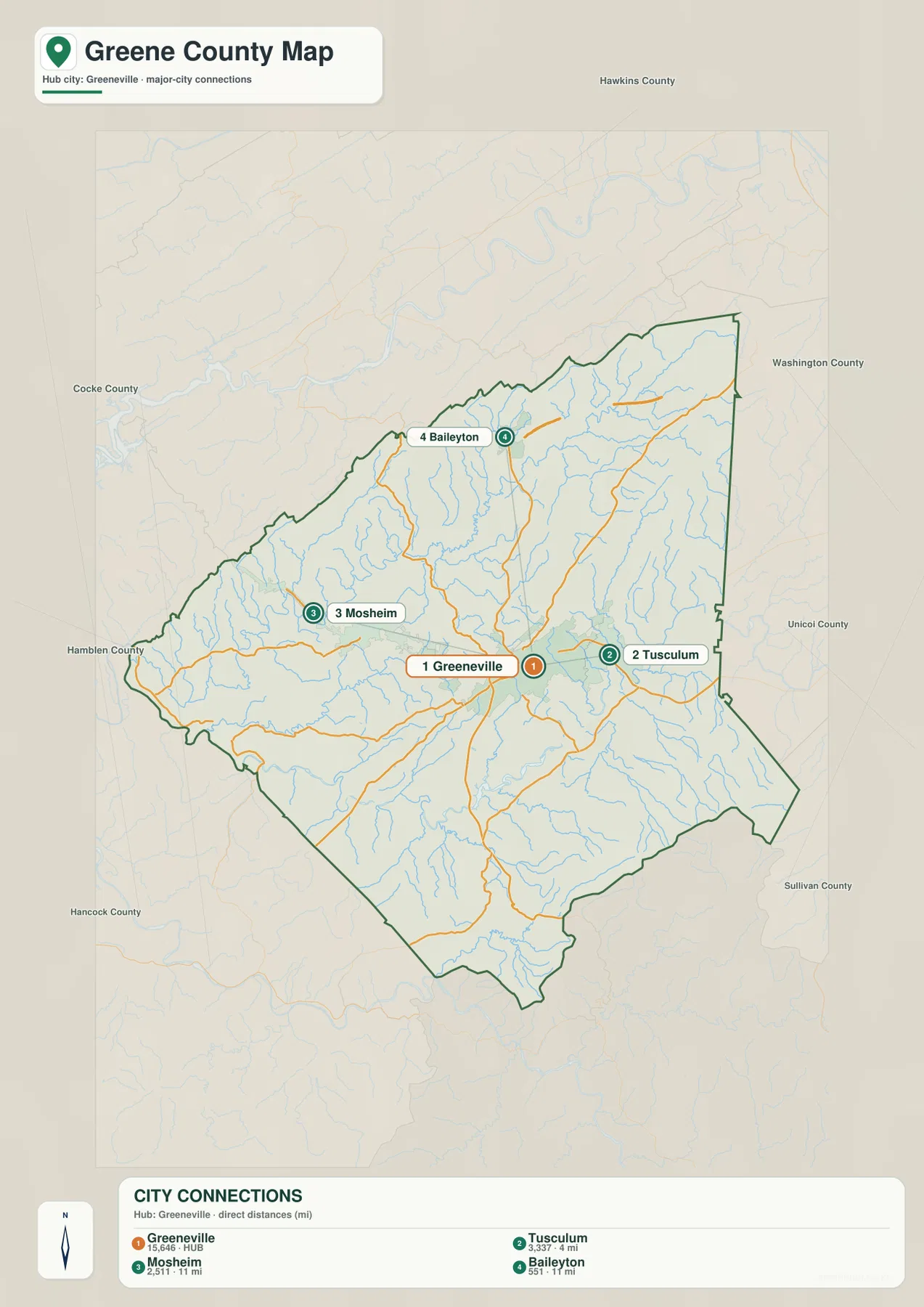
Neighboring labels such as Hawkins, Washington, Unicoi, Cocke, and Hamblen counties provide additional orientation around the map. The eastern and southeastern county lines become more irregular as the terrain rises, while the western side around Mosheim opens into broader lower ground. Starting with Greeneville and one outer town is usually enough to establish the correct part of the county before smaller roads and creeks are added.
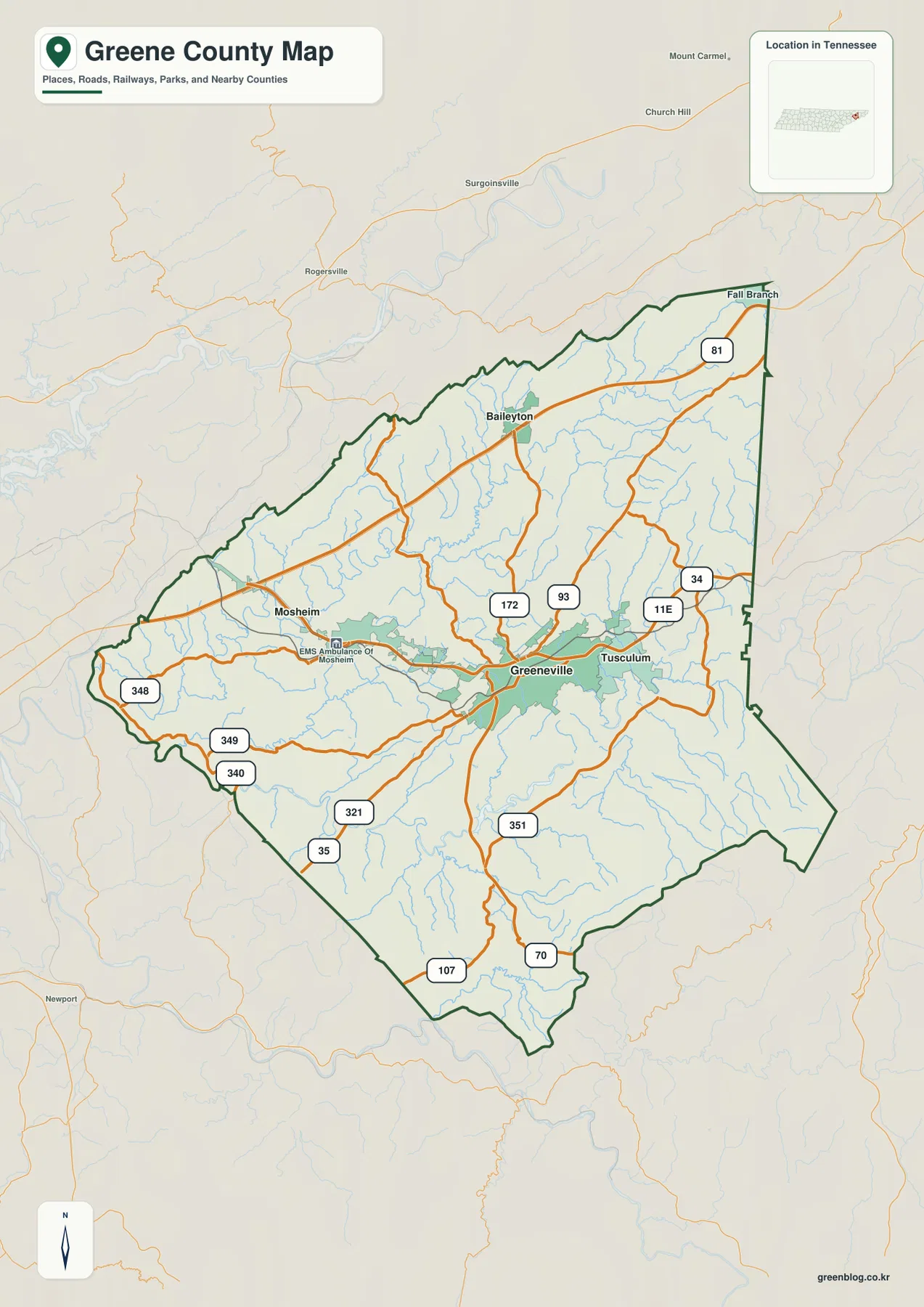
US 11E and US 321 organize the Greeneville road network
The base map places US 11E through the central corridor and uses US 321 as another strong route south and southwest of Greeneville. State Routes 172 and 93 extend north and northeast from the central area, while Route 34 helps identify the eastern side near Tusculum. Together, these routes give Greeneville a road pattern that is much denser than the mountain edge in the southeast.
West of Greeneville, Routes 348, 349, and 340 serve the Mosheim side and the southwestern interior. Farther south, Routes 35, 351, 107, and 70 provide separate links through the valleys toward the county edge. I-81 appears near the northeastern side as a larger regional corridor that is distinct from the street-and-highway cluster around Greeneville.
The elevation map helps explain why these roads do not form a simple grid. Central low ground allows several routes to meet around Greeneville, but the southern mountains and northern ridges force roads toward lower passes and valleys. Comparing the base map with the terrain surface makes those bends and gaps easier to understand without treating every route number as an isolated line.
Nolichucky River anchors a dense network of mountain and valley streams
The largest named water feature inside the county is the Nolichucky River along the southern half. It follows a lower corridor below Greeneville and receives water from several valleys extending out of the mountains and interior ridges. Little Chucky Creek is prominent in the west-central area, while Paint Creek and Cane Creek occupy narrower southern valleys.
Northern and central drainage is divided among several smaller streams. Lick Creek and Pigeon Creek follow long valleys in the northwest and north, and Gap Creek runs close to the northern county edge. Richland Creek and Green Creek are useful references nearer the central area, while Sinking Creek and Horse Creek mark separate eastern drainage corridors.
Combs Pond and Berry Pond provide smaller named water references. They do not shape the county in the same way as the Nolichucky River, but they help locate nearby creeks and terrain. A practical way to read the water map is to start with the Nolichucky, add Lick Creek for the northwest and Richland Creek near the center, then use Paint Creek, Cane Creek, or Horse Creek when the southern or eastern mountain valleys matter.
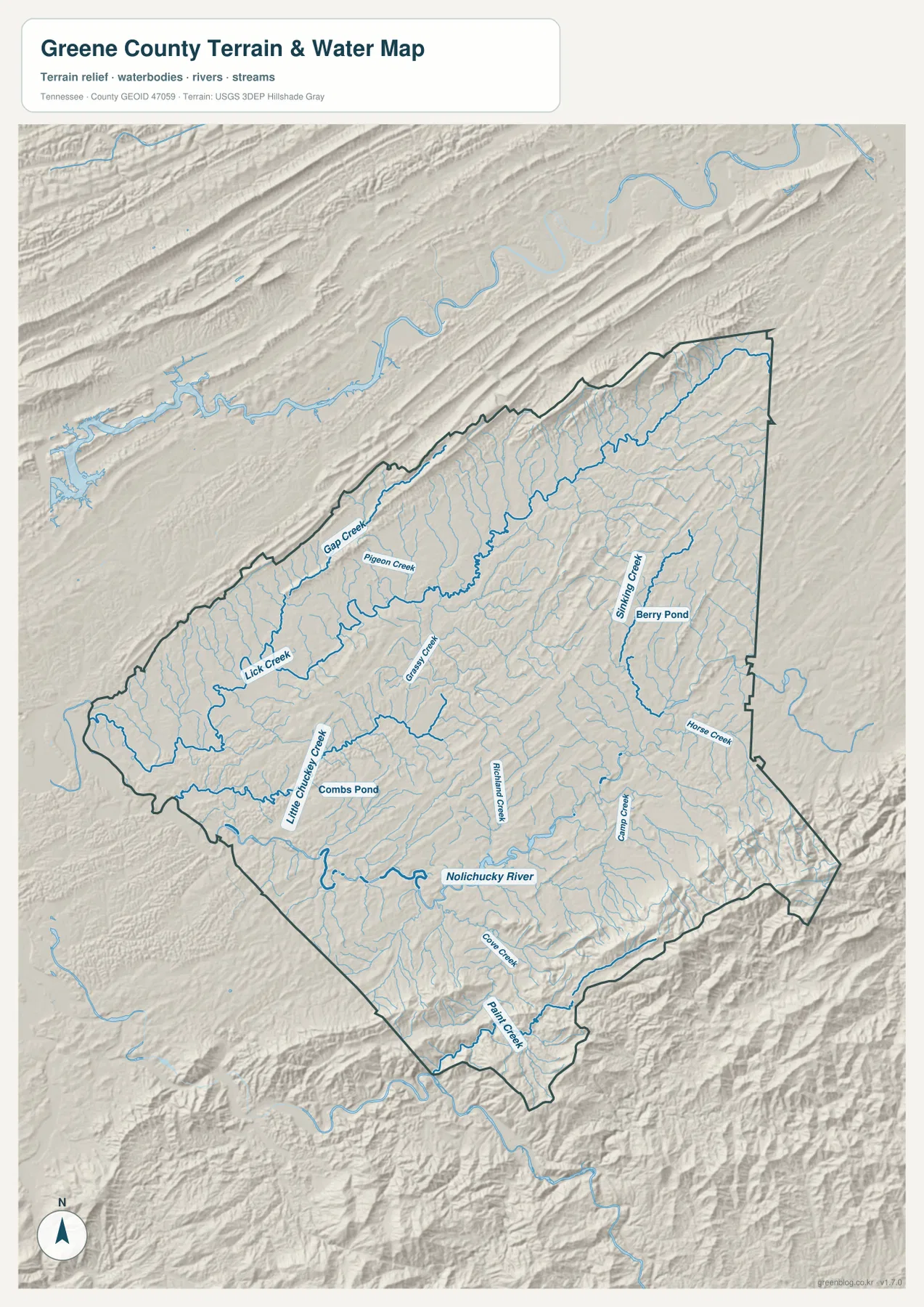
This water layer is intended for geographic reference. It does not establish current water level, flood extent, navigation access, or property boundaries. Its value here is showing where the major stream valleys sit in relation to Greeneville, roads, and the high terrain surrounding the central part of the county.
A 312–1,465 m range separates the central valleys from the southeastern mountains
The elevation map shows an actual range of about 312 to 1,465 meters, with a mean near 468 meters. Greeneville, Mosheim, and much of the central-western county appear in darker green and lighter green shades, indicating lower terrain. This broad lower area corresponds to the part of the county where settlements and major road connections are most visible.
The most dramatic rise occurs along the southeastern boundary. Yellow, brown, and dark-brown terrain increases quickly toward the mountain edge, and narrow valleys cut between steep slopes. Paint Creek and Cane Creek occupy some of those lower corridors, matching the pattern seen on the water map. The relief is large enough that a short map distance can represent a major change in elevation.
A second high belt follows the northern side. It is not as broad as the southeastern mountain block, but parallel ridges and valleys are clearly visible above the lower central county. This creates a valley-and-ridge setting in which Greeneville sits between higher terrain to the north and much higher mountains to the southeast, while streams follow the lower corridors between them.
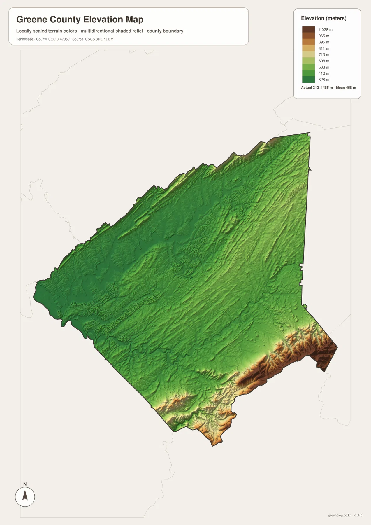
The elevation colors are intended for relative terrain comparison across the county, not for a survey-grade elevation at a specific property. They are useful for explaining why roads favor valley corridors and why streams follow long low paths between ridges. The central-to-southeastern rise is especially clear when the elevation and water maps are viewed side by side.
Greeneville links the road network, creek valleys, and outer communities
The city map first establishes Greeneville as the hub, with Tusculum close to the east and Mosheim and Baileyton farther away in different directions. The county map adds US 11E, US 321, and the state routes that connect those places. The water map then shows how the central and southern valleys are organized around the Nolichucky River and its tributaries.
The elevation layer completes the picture. Greeneville and Mosheim occupy comparatively low ground, while the southeastern boundary rises into very high mountain terrain and the northern side carries another long ridge belt. The same straight-line distance can therefore cross very different landscapes depending on direction, which is why the Tusculum, Mosheim, and Baileyton connections should not be interpreted as equivalent travel routes.
Choose the map according to the question. The city map is the cleanest for straight-line distance and town position. The county map is better for roads and boundaries, the water map is best for the Nolichucky and creek network, and the elevation map makes the central-valley versus mountain contrast easiest to see.
Choosing and downloading the A3 JPG maps
The WebP images in the article are convenient for quick viewing, while the JPG originals in the ZIP are better for printing, enlargement, and offline reference. For road-focused work, mark Greeneville and only the destination town and main route needed on the county map. Use the city map separately when the straight-line comparison between Greeneville, Tusculum, Mosheim, and Baileyton is more important.
For water-focused work, keep the Nolichucky River and the relevant creek labels on the water map instead of placing them over the road network. The elevation image is especially useful in color because the low central valleys and high southeastern mountains are distinguished by terrain shading. A3 output also leaves more room for small creek names and route numbers than the browser preview.
The downloadable ZIP contains the high-resolution A3 JPG originals for the county, city, water, and elevation maps shown on this page. They can be used for classroom comparison, presentations, route notes, regional study, or personal offline storage when a larger image is more useful than the web preview.
Frequently Asked Questions
What do the Greeneville-to-city distance labels mean?
The city map uses straight-line distance rather than driving mileage. Greeneville to Tusculum is about 4 miles, while Greeneville to Mosheim and Greeneville to Baileyton are each about 11 miles.
Where are the Nolichucky River and the highest terrain?
The Nolichucky River follows the lower southern valleys. The elevation map shows about 312–1,465 meters, with the highest terrain concentrated along the southeastern boundary and another long ridge belt along the north.
Sources and reference data
County boundaries and general location can be compared with U.S. Census Bureau TIGER/Line. Local county history and reference material are available from the Tennessee State Library and Archives Greene County fact sheet, and regional road information can be compared with the Tennessee Department of Transportation regional reference.
For broader hydrography reference, see USGS National Hydrography. Elevation data can be compared with the USGS 3D Elevation Program. The descriptions on this page are based on the towns, roads, water features, and elevation patterns visible in the supplied Greene County maps.
Map File Information
Download the high-resolution A3 JPG originals for the Greene County county, city, water, and elevation maps shown in this article.
- Included Files: County map, city map, water map, elevation map
- File Type: ZIP containing 4 JPG files
Related Maps
Green Map creates custom-edited map images using open geographic data sources such as geoBoundaries, Natural Earth, OpenStreetMap, and government open data. These maps are edited visual materials, not raw data files, and are provided for education, documents, presentations, and graphic reference.