McMinn County is easier to understand as a set of long valleys and ridges than as a simple circle around Athens. Athens is the main city and county seat, but Niota, Englewood, Etowah, Riceville, and Calhoun occupy different parts of the county along separate road corridors. You can download the four McMinn County Map files on this page as high-resolution JPGs for A3 output; the set separates roads and places, city spacing, waterways, and elevation so each layer stays readable.
The maps also show a strong physical contrast. Chickamauga Lake touches the western side, a dense network of creeks crosses the interior, and the elevation surface rises from low green valleys to ridges that reach about 708 meters near the southeastern edge. Many roads follow the same southwest-to-northeast grain as the terrain. Reading the county this way explains why Athens, Etowah, Englewood, and Niota can be fairly close in straight-line distance while still sitting in different valleys or along different road approaches.
Table of Contents
Athens sits where north–south travel meets roads to the eastern towns
The general county map makes Athens the clearest orientation point. Its urban area occupies the central-eastern part of the county, while I-75 approaches from the southwest near Calhoun and Riceville, passes west of Athens, and continues toward the northeast. Other mapped route numbers include 11, 30, 39, 68, 163, 305, 307, 310, and 718. Several of them meet near Athens or branch toward Niota, Englewood, and Etowah, so the road pattern looks more like connected valley corridors than a regular street grid.
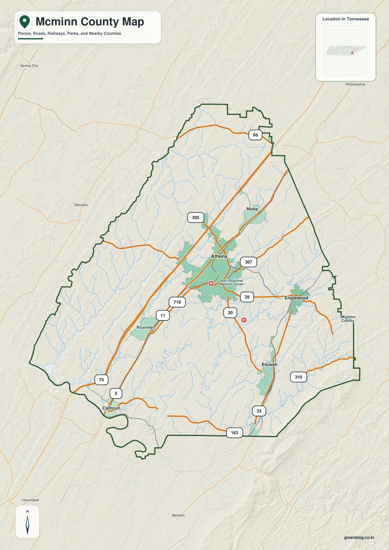
Niota lies northeast of Athens along the same broad travel direction, while Englewood is farther east. Etowah is southeast of Athens and forms a distinct developed area near the eastern side of the county. Riceville and Calhoun provide useful references along the southwestern approach. Looking at all of these places together prevents the map from being reduced to an Athens-only view and makes the elongated shape of the county easier to follow.
McMinn County meets Meigs, Loudon, Roane, Monroe, Polk, and Bradley counties. Those names matter because roads and streams continue through the boundary. Calhoun sits close to the southwest side, and several eastern routes approach the Monroe and Polk directions. For regional comparison, it is usually more useful to follow one route or creek across the county line than to treat the outline as an isolated shape.
The map also labels Starr Regional Medical Center near Athens, which helps show where the most built-up road network is concentrated. It is still a county-scale reference rather than a street map: local addresses, every intersection, and current construction conditions are outside its purpose. For a clean A3 print, Athens and I-75 make good first anchors, followed by the outer towns and the numbered east–west routes.
The city map places four towns 5 to 14 miles from Athens
The city-connection map strips away much of the road detail and uses Athens as the hub. Niota is shown about five miles away, Englewood about seven miles, Etowah about nine miles, and Calhoun about fourteen miles from Athens. The legend identifies these as direct distances, so they should be read as straight-line spacing rather than driving mileage. That distinction is important in McMinn County because ridges and creek valleys can make an actual road trip less direct than the line between two city labels.
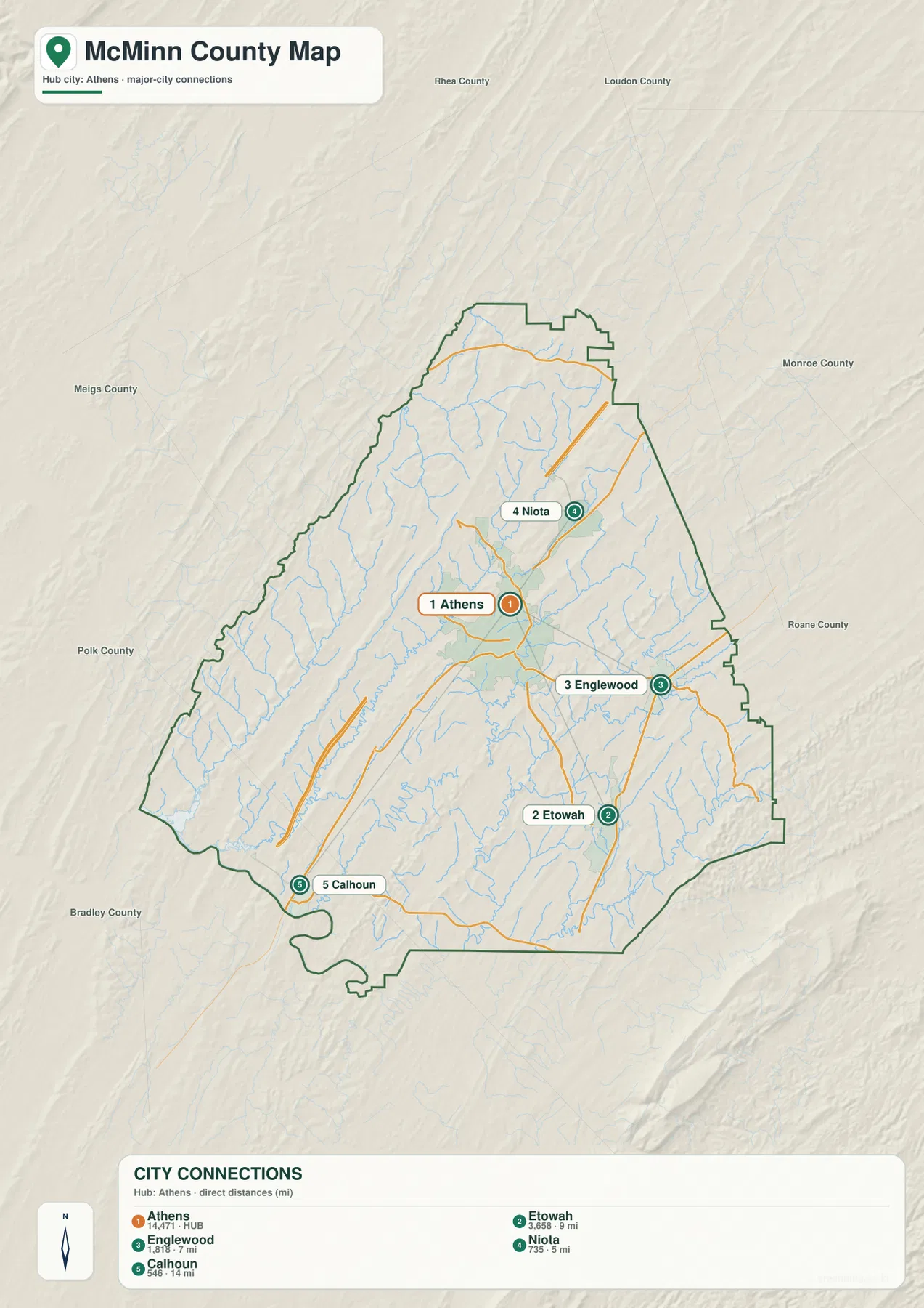
Niota is the closest of the four highlighted towns and sits northeast of the hub. Englewood and Etowah lie on the eastern side but are not on the same line from Athens: Englewood is more easterly, while Etowah is farther south. Calhoun is the most distant highlighted point and sits near the southwest end of the county. The pattern gives McMinn County a long diagonal arrangement rather than a compact cluster of towns around one center.
The developed footprints also differ in size. Athens has the largest green urban area on the map, Etowah forms a noticeable second cluster, and Niota, Englewood, and Calhoun are smaller. This makes the city map useful for a simple presentation about settlement distribution, while the full county map is better when route numbers and county edges matter. Moving from the simplified view to the detailed one keeps the city relationships clear before the road network is added.
Riceville appears on the general map but is not one of the numbered city-connection points. That is a design choice rather than a conflict between the maps. The general map carries more local labels, whereas the connection map focuses on a smaller set of towns around Athens. When a reader needs a quick location graphic, the simplified map is enough; when the question is which road reaches a place, the county map supplies the additional context.
Chickamauga Lake anchors the west while creek valleys divide the interior
The terrain-and-water map changes the way the county looks. Chickamauga Lake appears along the western edge, and Rogers Creek, Spring Creek, and North Mouse Creek occupy the western and central valleys. North Mouse Creek is especially prominent because it runs a long distance through the southwest-central part of the county, linking smaller tributaries and giving that side of McMinn County a clear drainage direction.
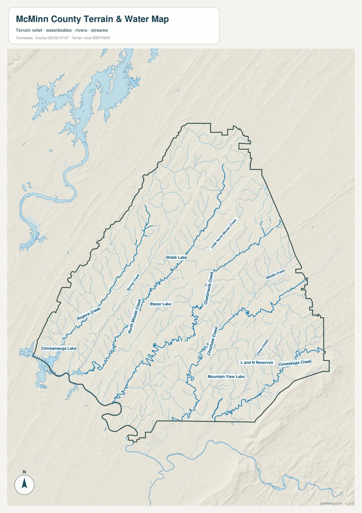
Near the middle of the county, the map labels Webb Lake and Blazer Lake. Oostanaula Creek runs through the central-eastern interior, with Little North Mouse Creek farther north and Middle Creek near the eastern side. These names are useful because they reveal multiple parallel drainage paths instead of one dominant river crossing the entire county. The creek courses bend between ridges, which becomes obvious when the water layer is compared with the elevation image.
The southeastern portion has its own set of features, including Chestuee Creek, Cane Creek, Conasauga Creek, L and N Reservoir, and Mountain View Lake. Conasauga Creek is close to the southeast boundary, while the small reservoirs and lakes occupy narrower valleys farther inside the county. This part of the map looks very different from the broad open water of Chickamauga Lake on the west, giving the county two distinct water settings within the same boundary.
This water image is meant for geographic reference, not for flood depth, current lake level, or boating clearance. Its strength is showing where named creeks and lakes sit relative to Athens, Etowah, and the county outline. For a school project or regional comparison, it is especially useful beside the elevation map because many of the blue lines occupy the lowest green corridors between the ridges.
Elevation climbs from 197-meter valleys to a 708-meter southeastern ridge
The elevation map uses an actual range of roughly 197 to 708 meters, with a mean near 278 meters. The broad pattern is more important than any single number. Long green valleys and tan-to-brown ridges repeat from southwest to northeast, producing a striped terrain that is characteristic of East Tennessee’s Ridge and Valley landscape. The result is a landscape of parallel low routes separated by narrow higher ground rather than one continuous mountain block.
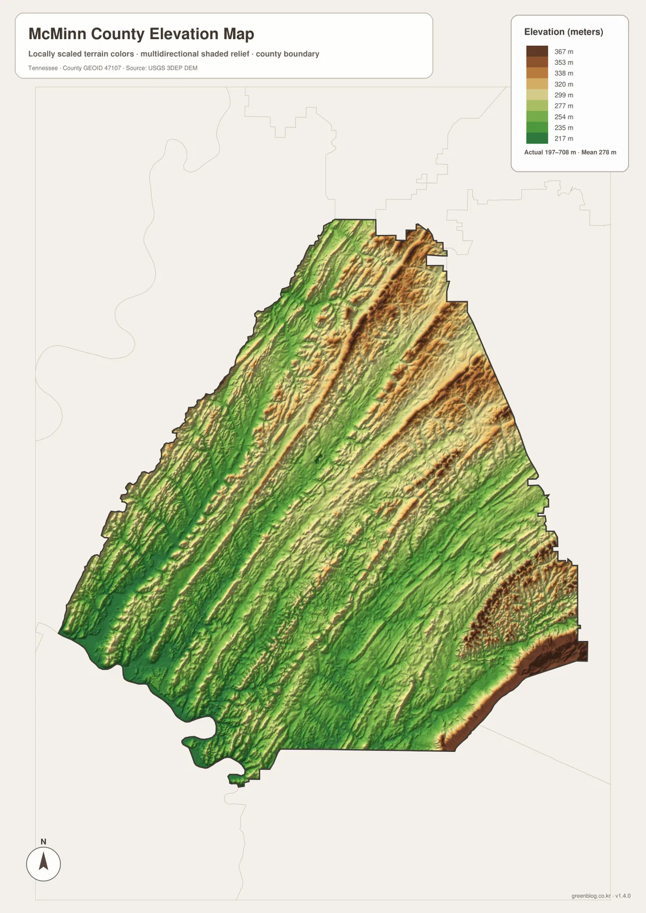
The darkest high-elevation colors are concentrated along the southeastern edge, and several elevated bands also run through the northeast. In contrast, wide parts of the southwest and central valleys remain green. Athens sits near a lower corridor between ridges, while Etowah and Englewood are closer to the higher eastern terrain. That difference helps explain why roads to the east do not simply radiate in straight lines from Athens.
Several named waterways follow the same terrain grain. North Mouse Creek and Oostanaula Creek occupy lower corridors, while smaller tributaries branch into side valleys. Comparing the two maps shows how drainage and transportation repeatedly use the lower ground between ridges. This is more informative than treating elevation as a list of spot heights because it connects the physical surface with the routes and towns shown elsewhere on the page.
The elevation surface is generalized for county-wide viewing. It is appropriate for comparing high and low parts of McMinn County, but it is not survey-grade elevation for a parcel, building site, or engineering design. For annotation, a useful approach is to mark the low green valleys first, then trace I-75 and the main creeks to see where transportation and drainage share the same broad corridors.
Choose the map by the question rather than forcing every layer into one image
For county boundaries, named towns, and numbered roads, the general map carries the most detail. The city map is cleaner when the only question is how Athens relates to Niota, Englewood, Etowah, and Calhoun. The water map is the best choice for locating Chickamauga Lake, North Mouse Creek, Oostanaula Creek, and the southeastern drainage, while the elevation map makes the 197-to-708-meter relief and parallel ridges immediately visible. Each file answers a different practical question without burying the page in overlapping symbols.
Census figures add county-wide scale without replacing what the maps show. McMinn County had 53,276 residents in the 2020 census, and the July 2025 estimate is 57,404. The Gazetteer figures list about 430.1 square miles of land and 2.1 square miles of water. Those county-wide totals do not show where individual neighborhoods are located, so the city footprints, road corridors, creeks, and elevation remain the more useful sources for understanding how the county is arranged internally.
For printing, select the file that matches the subject. A route-focused handout can pair the general map with the city map, while a physical-geography page can place the water and elevation images side by side. The ZIP contains the same four subjects as high-resolution JPG files prepared for A3 use, making them suitable for print, presentation slides, document layouts, and annotated comparisons without relying on the smaller WebP previews shown in the article.
Frequently Asked Questions
Are the Athens-to-town distances driving distances?
No. The city-connection map labels direct, straight-line distances: about 5 miles to Niota, 7 miles to Englewood, 9 miles to Etowah, and 14 miles to Calhoun. Use the general road map when you need to see the actual direction of the road network between those places.
What water features are labeled besides Chickamauga Lake?
The map labels North Mouse Creek, Oostanaula Creek, Rogers Creek, Spring Creek, Little North Mouse Creek, Middle Creek, Chestuee Creek, Cane Creek, and Conasauga Creek, along with smaller water bodies such as Webb Lake, Blazer Lake, L and N Reservoir, and Mountain View Lake.
Why does the southeastern edge look so much higher?
The elevation image spans roughly 197 to 708 meters, and its highest colors are concentrated on ridges near the southeast boundary, with additional high bands in the northeast. Lower green valleys extend through much of the southwest and center, creating the repeated ridge-and-valley pattern seen across the county.
Map File Information
The ZIP contains the McMinn County general map, city-connections map, terrain-and-water map, and elevation map as high-resolution JPG files for A3 use.
- Included Files: County map, city-connections map, water map, elevation map
Related Maps
Sources and References
- Tennessee State Library and Archives: McMinn County fact sheet
- Tennessee Department of Transportation: McMinn County road reference
- U.S. Census Bureau: McMinn County QuickFacts
- U.S. Census Bureau TIGER/Line boundary data
- USGS National Hydrography
- USGS 3D Elevation Program
Green Map creates custom-edited map images using open geographic data sources such as geoBoundaries, Natural Earth, OpenStreetMap, and government open data. These maps are edited visual materials, not raw data files, and are provided for education, documents, presentations, and graphic reference.