Maury County, Tennessee is easiest to understand by starting with Columbia, then looking north toward Spring Hill and southwest toward Mount Pleasant. Duck River bends through the middle of the county, while major roads spread from Columbia toward the county edges. This page provides separate county, city, water, and elevation maps, and the download box below contains the same four maps as high-resolution A3 JPG files in one ZIP archive.
The four views are useful because no single layer tells the whole story. The general map shows US 31, US 412, US 43, US 431, I-65 and other routes around Columbia. The water map replaces road emphasis with Duck River and its tributaries, while the elevation map reveals a 153–356 meter terrain range with low river valleys and higher ridges. The city map strips away much of that detail so the spacing among Spring Hill, Columbia, and Mount Pleasant is easier to see.
Table of Contents
Columbia sits where Maury County’s main road network comes together
Columbia is the county seat and the clearest road reference in the general map. US 31 runs north and south through the city, linking the Columbia area toward Spring Hill in the north and communities farther south. US 412 crosses the county from west to east through Columbia, while US 43 angles toward Mount Pleasant in the southwest. US 431 provides an eastern north–south route, and I-65 runs close to the county’s eastern side. Together, these roads make Columbia look less like an isolated city and more like the central junction of several county-scale travel directions.
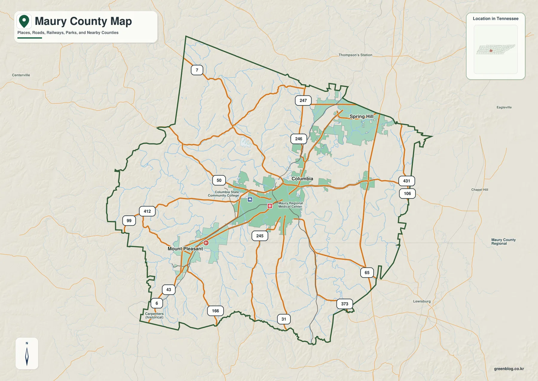
Spring Hill appears close to the northern county line, while Mount Pleasant is southwest of Columbia. Beyond the boundary, the map also labels directions toward Centerville, Chapel Hill, Lewisburg, and neighboring counties. Those outside labels are useful because the highways and local road network continue beyond Maury County rather than ending at the boundary. For a reader who is unfamiliar with the area, matching each edge with its neighboring direction makes the irregular county outline much easier to place.
The general map also marks local reference points such as Columbia State Community College and Maury Regional Medical Center. They help identify the built-up Columbia area without turning the map into a street map. For a report, classroom handout, or regional overview, this is the most complete single page because it keeps county limits, cities, major roads, streams, and nearby places visible at the same time.
Spring Hill and Mount Pleasant pull the city pattern in opposite directions
The city-connections map deliberately reduces the number of labels and highlights three places: Spring Hill, Columbia, and Mount Pleasant. Spring Hill is used as the northern hub in this version. Columbia lies about 9 miles to the south by the map’s direct-distance reference, while Mount Pleasant is about 22 miles away to the southwest. That simple arrangement makes the county’s settlement pattern easy to grasp before adding roads, creeks, and terrain.
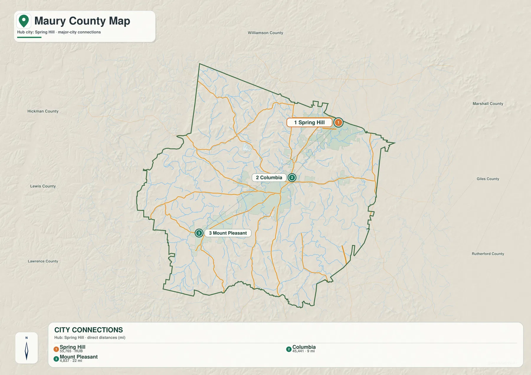
Spring Hill sits near the Williamson County side and gives the northern end of Maury County a strong urban reference. Columbia occupies the middle of the county’s populated road network, and Mount Pleasant is clearly separated to the southwest. The three places therefore do not form one continuous urban block. Their spacing helps explain why routes from Columbia fan in different directions and why the northern edge of the county feels closely tied to the Spring Hill–Williamson County side.
This simplified map is not meant to replace the general county map. It is better suited to a slide, worksheet, or first-look explanation where the main question is location rather than road detail. Once the three-city arrangement is clear, the general map can add US 31, US 412, US 43, US 431, and the county boundary without overwhelming the reader.
Duck River is the organizing water feature through central Maury County
Duck River dominates the water map. It enters from the west, forms a series of broad bends through the central part of Maury County, and continues eastward after passing the Columbia area. The river is not a straight divider; its meandering course creates a long low corridor through the county and gives many smaller streams a common direction of flow.
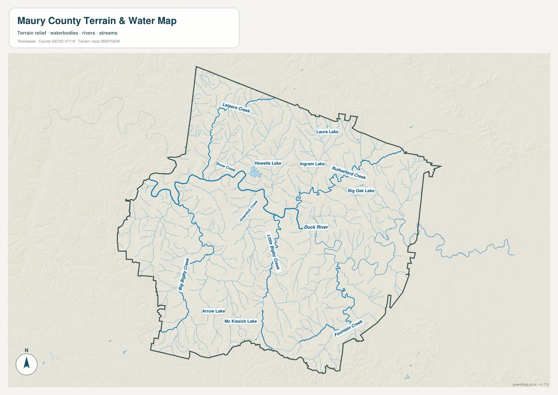
North of Duck River, the map labels Leiper’s Creek and Snow Creek, along with smaller branches that drain toward the central river corridor. Rutherford Creek appears in the northeast-central area. South and southwest of the river, Big Bigby Creek and Little Bigby Creek form longer drainage lines, while Fountain Creek reaches across the southeast. The map also marks smaller water bodies such as Howells Lake, Ingram Lake, Big Oak Lake, Laura Lake, Arrow Lake, and McKissick Lake.
The value of the water map becomes clearer when it is compared with the road map. Routes around Columbia and Mount Pleasant cross multiple tributaries, and several roads bend along lower ground rather than following perfectly straight county-wide lines. This file is a static geographic reference rather than a live flood or boating map, but it clearly shows where the county’s main river lies and how the smaller creek network fills the surrounding valleys.
Elevation rises away from the river valleys into a broken ridge landscape
The elevation map gives an actual terrain range of about 153 to 356 meters, with a mean near 225 meters. Low green bands follow Duck River and many of the tributary valleys. Higher tan and brown ground appears around those valleys in a repeated ridge pattern, so Maury County does not read as a broad flat plain even though its highest elevations are modest compared with mountain counties farther east.
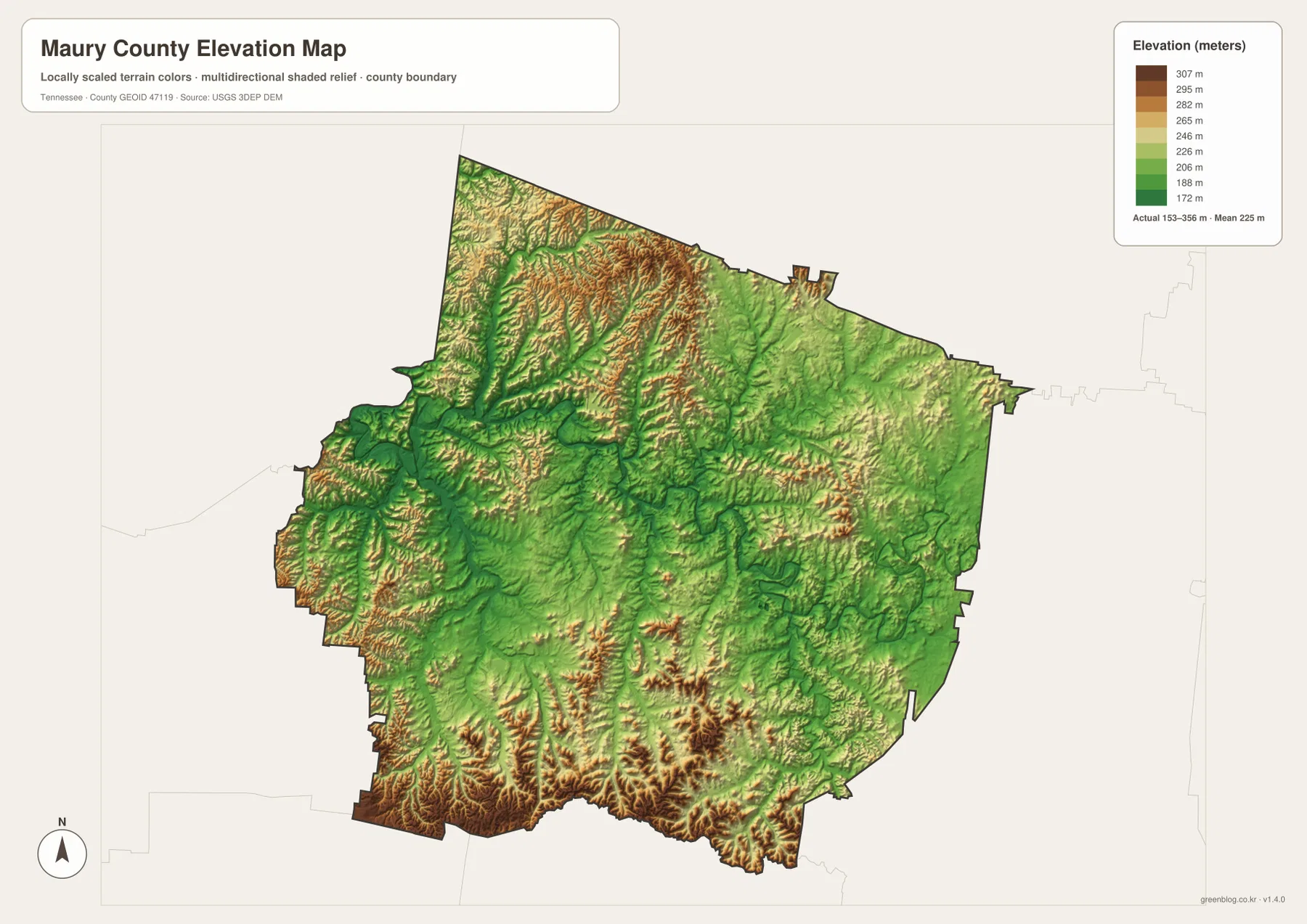
The northwest has some of the most tightly packed ridge-and-valley texture on the map. Higher ground is also common near the southern border, where narrow green drainage cuts divide brown and tan uplands. By contrast, the central Duck River corridor forms a longer connected low zone. When the elevation and water maps are placed side by side, Leiper’s Creek, Big Bigby Creek, Little Bigby Creek, and other streams can be followed through these lower terrain cuts.
The northern area between Spring Hill and Columbia mixes ridges with broader low corridors, while the southwest around Mount Pleasant also shows more relief than the city map alone suggests. That matters when the maps are used together: short straight-line distances between labeled places do not mean the intervening landscape is flat. The elevation file is best for county-scale comparison of high and low ground rather than for detailed contour or trail navigation.
Population and area figures add scale to the map without replacing it
The county data included with the package lists 100,974 residents in the 2020 census and a July 2025 estimate of 118,131. That estimate is roughly 17 percent above the 2020 count. Gazetteer figures list about 613.1 square miles of land and 2.5 square miles of water. Using the 2020 population and land area gives an average of about 164.7 residents per square mile.
Those numbers are most useful when paired with the maps. The city-connections view shows where major population centers are located, while the water and elevation maps show large rural areas divided by river valleys and ridges. A countywide average cannot show the contrast between the Spring Hill–Columbia side of the county and more lightly developed outer areas. Keeping the census year and the estimate year visible also prevents the two population figures from being treated as the same type of measurement.
Use each Maury County map for a different question
Choose the general county map when the goal is to locate Columbia, Spring Hill, Mount Pleasant, major highways, county boundaries, and nearby county directions on one page. Use the city map when the main point is the spacing among the three highlighted places. The water map is the clearest file for Duck River, tributaries, and small lakes, while the elevation map is better for showing how those watercourses occupy lower valleys between ridges.
Pairing two files can be more informative than crowding extra labels onto one map. A road-focused report can place the county map beside the water map to show where transportation and river corridors meet. A physical-geography lesson can compare the water map with elevation and trace how tributaries follow lower terrain. Because every map is kept as a separate high-resolution JPG in the archive, the files can be used independently in slides, reports, classroom worksheets, or printed notes.
The download ZIP contains the four map types shown on this page: the general county map, city-connections map, terrain-and-water map, and elevation map. They are prepared at an A3-oriented resolution so readers can print them at larger size or crop and insert the most relevant map into a document without relying on the smaller WebP previews.
Frequently Asked Questions
How should I distinguish Columbia and Spring Hill on the maps?
Columbia is the county seat and sits near the middle of the county’s main road network. Spring Hill is much farther north, close to the Williamson County side. The city-connections map makes that north–south separation especially clear, while the general map adds US 31 and the surrounding road network.
Where does Duck River run through Maury County?
Duck River enters from the west and meanders through the central part of the county, passing the Columbia area before continuing east. Leiper’s Creek, Snow Creek, Big Bigby Creek, Little Bigby Creek, Fountain Creek, and many smaller streams occupy the surrounding drainage network.
What does the elevation map show most clearly?
The strongest feature is the contrast between low river valleys and higher ridges. The map reports a 153–356 meter actual range with a mean near 225 meters. Green lowlands follow Duck River and tributaries, while higher tan and brown terrain becomes prominent in the northwest and across parts of the south.
Map File Information
The ZIP contains four A3 high-resolution JPG files for Maury County: the general county map, city map, water map, and elevation map shown on this page.
- Included Files: county map, city map, water map, elevation map
- File Type: JPG
Related Maps
- Alamo to Gadsden: A Crockett County Tennessee Map
- Altamont, Monteagle, and Plateau Valleys — Grundy County Tennessee Map
- Around Chattanooga: Hamilton County Tennessee Map
Sources and References
- Tennessee State Library and Archives — Maury County fact sheet
- Tennessee Department of Transportation — Maury County road reference
- U.S. Census Bureau — Maury County QuickFacts
- U.S. Census Bureau — TIGER/Line boundary data
- USGS — National Hydrography
- USGS — 3D Elevation Program
Green Map creates custom-edited map images using open geographic data sources such as geoBoundaries, Natural Earth, OpenStreetMap, and government open data. These maps are edited visual materials, not raw data files, and are provided for education, documents, presentations, and graphic reference.