You can download the Marshall County Tennessee Map files on this page as four high-resolution JPGs prepared for A3 output. The set separates the county into a general road-and-place map, a simplified city-connection view, a terrain-and-water map, and an elevation map. That separation works well for Marshall County because Lewisburg is the obvious road hub, while the Duck River, smaller creeks, and a much hillier southern landscape add detail that is easy to miss on a single map.
The first contrast to notice is north versus south. Chapel Hill lies in the northern part of the county near the broad Duck River corridor. Lewisburg sits farther south, close to the center of the road network, and Cornersville lies to its southwest. Petersburg appears near the southeastern edge on the general map. The elevation image then adds another layer: much of the north is lower and smoother, while the southern half is cut by tightly spaced ridges and valleys.
Table of Contents
Lewisburg sits where county routes spread in several directions
The general map makes Lewisburg the easiest starting point. Its built-up area is the largest labeled urban footprint, and roads leave it toward every side of the county. I-65 runs close to the western edge, providing a very different north-south path from US 431 on the eastern side. Between them, the map labels a web of state routes including 50, 64, 106, 129, 130, 270, 271, and 272. Instead of forming a regular grid, these roads bend around valleys and connect separate communities across a long north-south county shape.
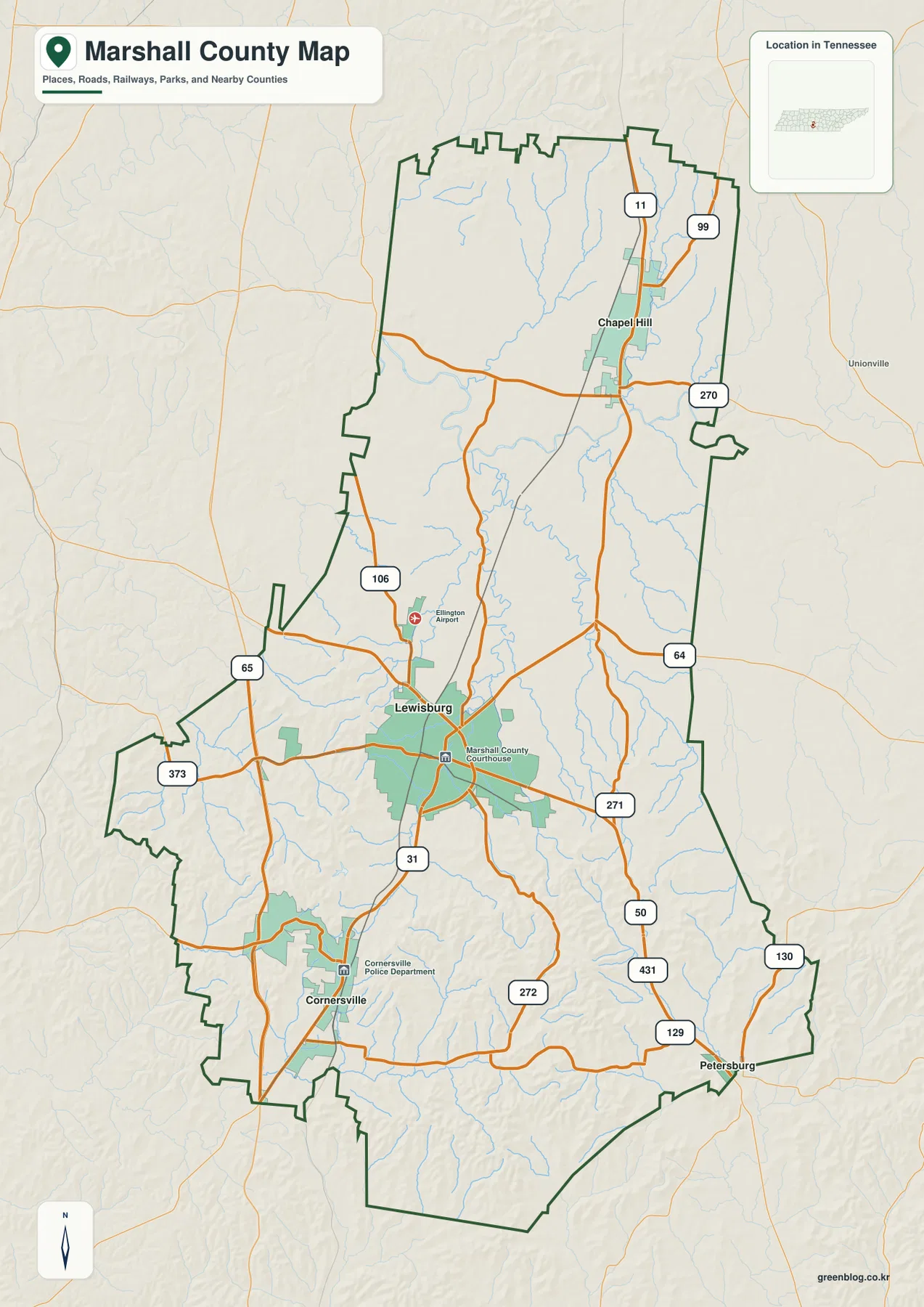
Chapel Hill is a useful northern reference because it sits well away from Lewisburg and close to the Duck River side of the county. Cornersville marks the southwest, near the I-65 side of Marshall County. Petersburg adds a southeastern reference near the boundary. Together, those places prevent the county from being read as a circle around Lewisburg and make it easier to see how long the county is from north to south.
The surrounding counties also explain the road directions. Maury County is to the west and northwest, Rutherford lies north, Bedford and Williamson are on the eastern side, and Lincoln and Giles counties meet Marshall County along the south and southwest. Roads and streams do not stop at those lines, so the boundary is most useful when it is treated as a reference for where a route or watercourse leaves one county and enters another.
The city map reduces Marshall County to three clear settlement anchors
The city-connection image deliberately removes much of the detail and emphasizes Lewisburg, Cornersville, and Chapel Hill. Lewisburg is marked as the hub. Cornersville is shown about nine miles away to the southwest, while Chapel Hill is roughly twelve miles to the north. That simple spacing is useful when the full county map feels busy, especially for a presentation, classroom handout, or location graphic that only needs the main settlement directions.
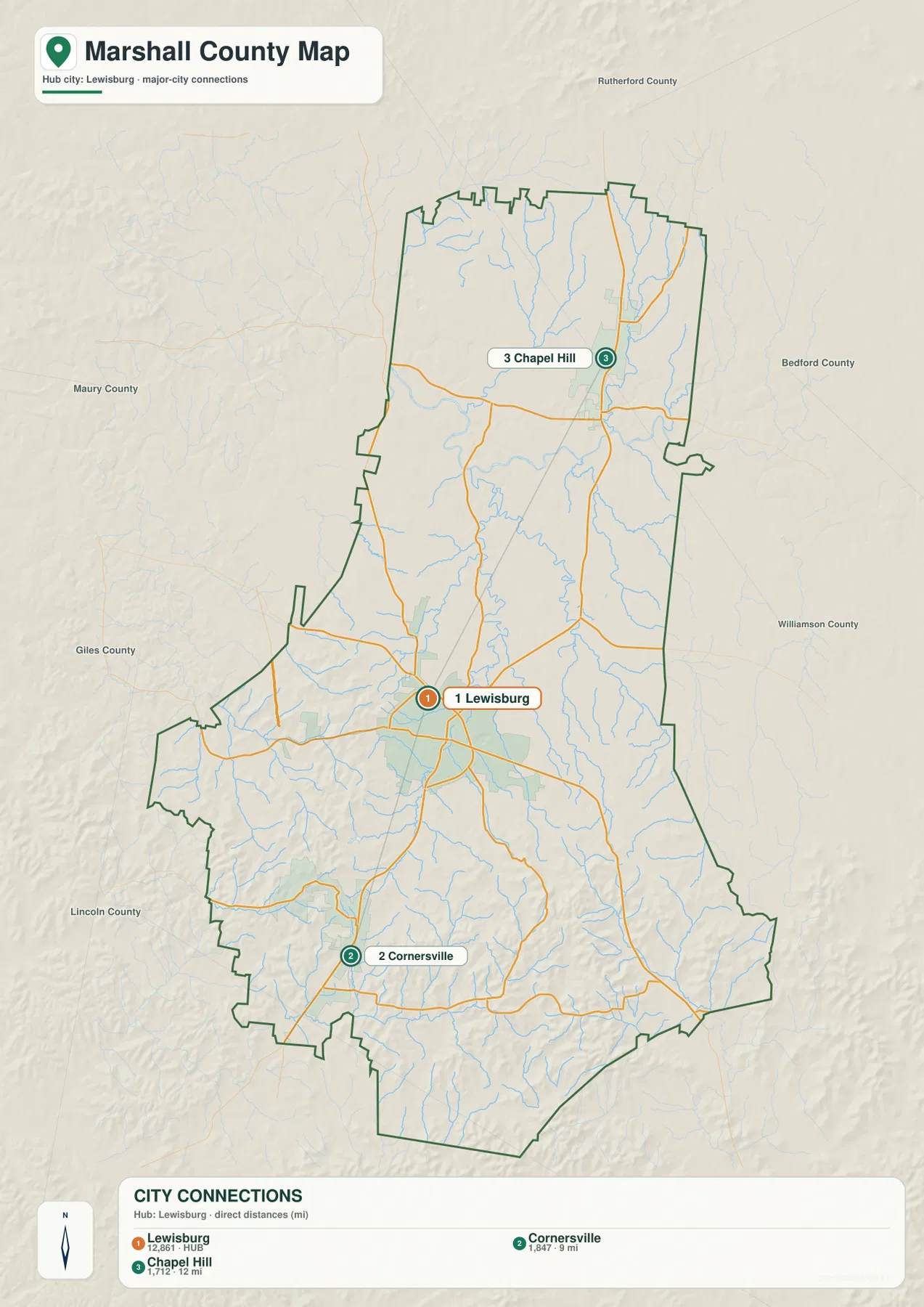
The map also makes the scale difference obvious. Lewisburg has the broadest developed footprint and the greatest concentration of road lines. Chapel Hill and Cornersville are much smaller, separated from the hub by stretches of open land, streams, and local roads. That pattern matters when the map is used to explain where services, neighborhoods, or major routes are concentrated: a countywide outline should not be mistaken for one continuous urban area.
Petersburg is not one of the three highlighted city-connection points, even though it appears on the general map near the southeast boundary. The difference is intentional. The city map is a simplified comparison, while the county map keeps more place names and route detail. Using both avoids the common problem of forcing every useful label into a single crowded image.
Duck River defines the north, while smaller creeks cut through the interior
The water map gives northern Marshall County a very different appearance from the road map. Duck River enters from the west in a broad looping course and crosses the northern section of the county. Caney Creek and Spring Creek approach from the north, while Rock Creek, Big Rock Creek, East Rock Creek, and Snake Creek occupy the middle. Farther south, Richland Creek and several smaller channels drain the more dissected terrain.
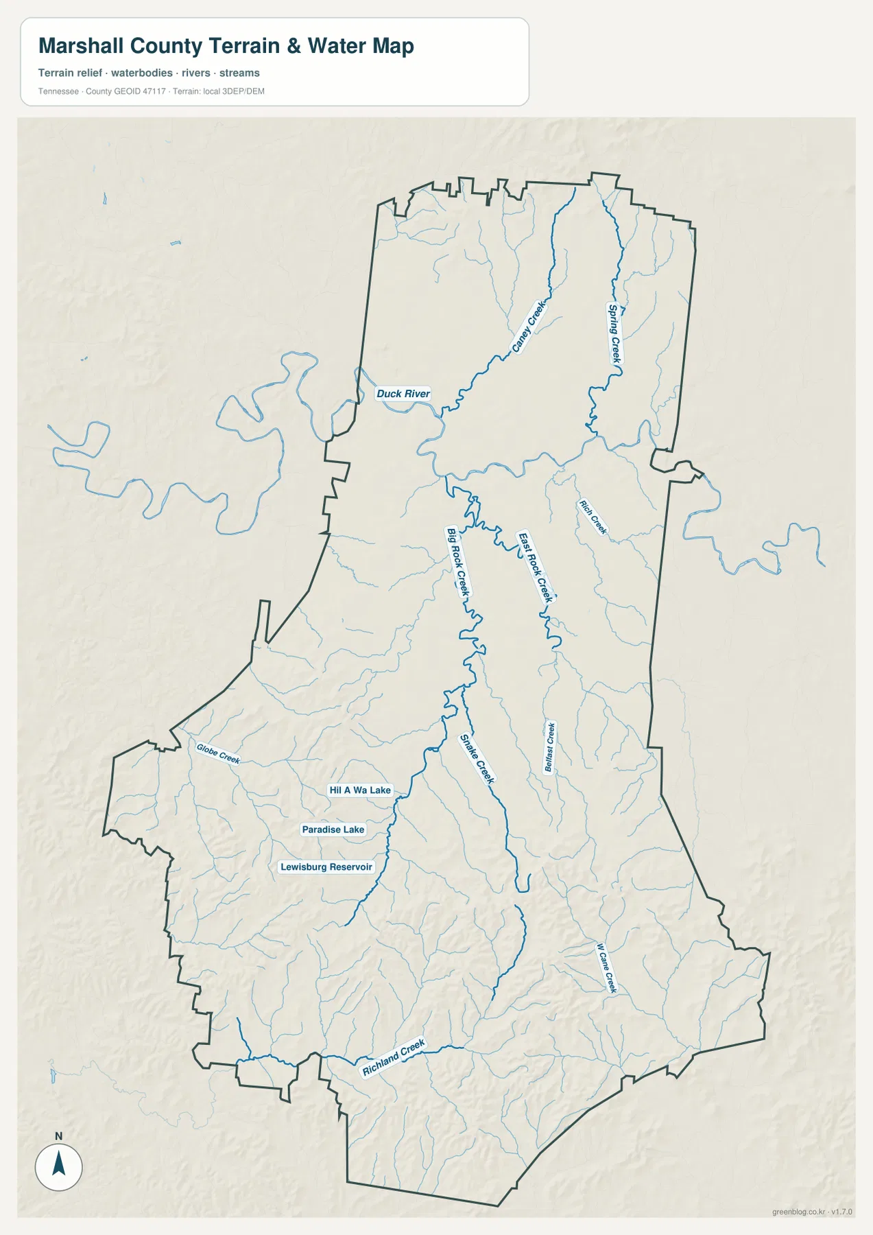
Near Lewisburg, the map labels Lewisburg Reservoir, Paradise Lake, and Hill A Wa Lake within a relatively compact area. These small water bodies do not dominate the county the way Duck River does, but they are useful local references because they sit close to the principal urban center. The result is a water network with two scales: one large river corridor in the north and many smaller creeks, ponds, and reservoir features farther south.
Comparing the water map with the road map helps explain why some routes curve and why direct-looking places may not be connected by a straight road. Creeks occupy low valleys, and bridges concentrate crossings at selected points. The map is not a live flood or navigation product, but it is detailed enough to show which named channels shape the county and where the major river lies in relation to Chapel Hill and Lewisburg.
Marshall County’s strongest terrain contrast appears in the southern half
The elevation map reports an actual range of about 166 to 386 meters and a mean elevation of about 249 meters. Broad green areas dominate much of the northern half, including the Duck River side of the county. South of Lewisburg, the relief becomes much more textured. Tan and brown ridges appear in clusters across the southwest, south-central, and southeastern sections, separated by narrow green valleys.
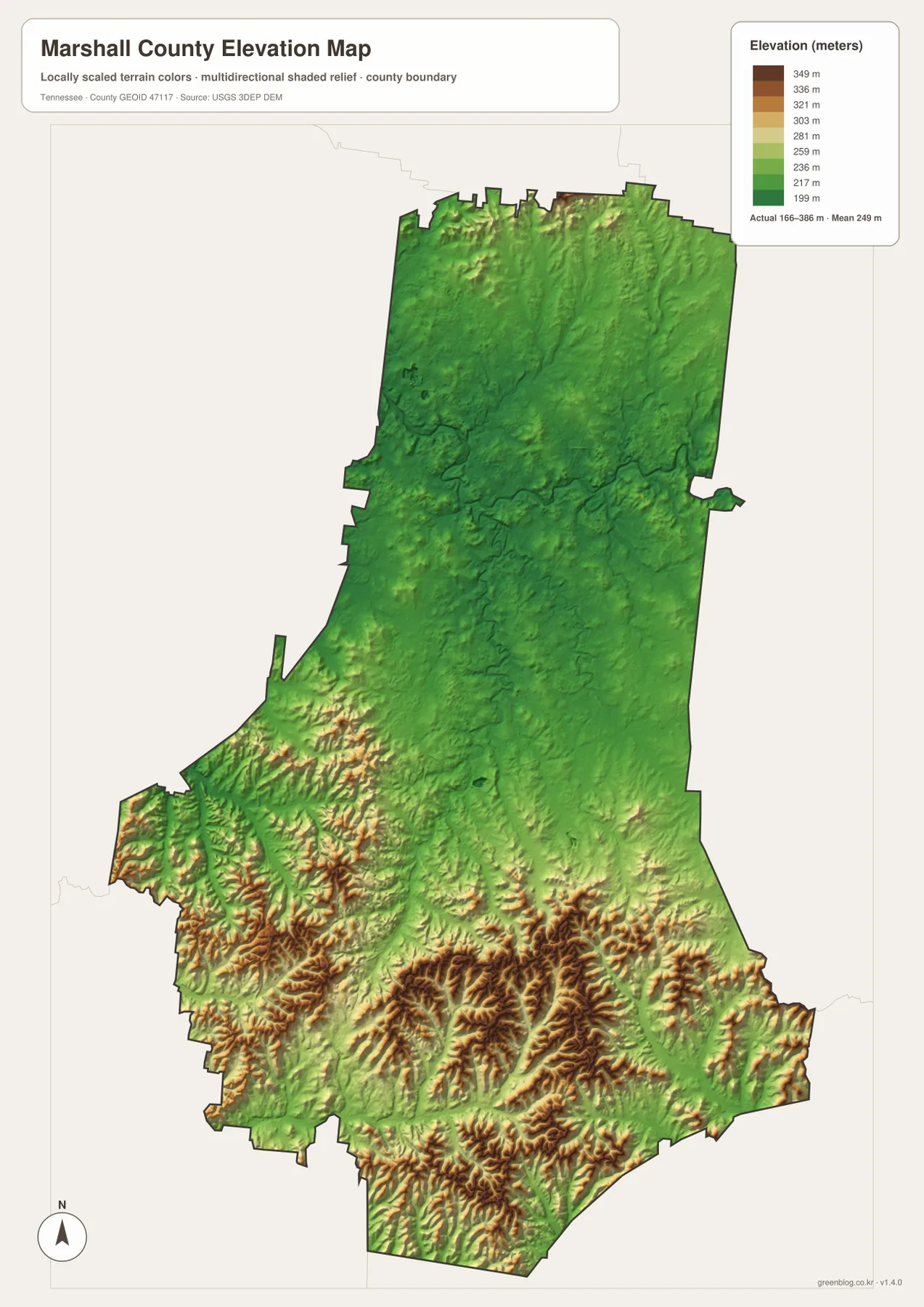
This is not a mountain-county landscape, but the local relief is strong enough to change the feel of the map. Around Cornersville and toward the southern border, short ridges repeat closely and create many small drainage valleys. The southeast near Petersburg shows a similar mix of higher ground and narrow low corridors. North of Lewisburg, the lower colors cover wider areas, and the Duck River corridor fits naturally into that broader lowland pattern.
The elevation image is especially useful beside the water map. Many of the thin tributaries sit in the green cuts between higher ridges, while the northern river occupies a much broader low zone. That relationship explains the dense branching of the creek network in the south and provides a physical-geography view that the road layer alone cannot show.
Choose the file by the question you need to answer
Use the general county map when the task is to locate Lewisburg, surrounding communities, county boundaries, and the principal roads on one page. The city map is cleaner for showing the relative positions of Lewisburg, Chapel Hill, and Cornersville. The water map is the best choice for Duck River, Lewisburg Reservoir, and the creek network, while the elevation map is the clearest way to show the low northern landscape against the ridge-heavy south.
Census references included with the package provide a useful sense of county scale. Marshall County had 34,318 residents in the 2020 census, and the July 2025 estimate is 38,071. Gazetteer figures list about 375.5 square miles of land and 0.7 square miles of water. Those countywide totals do not show where people live; the city and road maps show the concentration around Lewisburg, while the water and elevation maps show why large parts of the county remain visually different from the urban center.
For print use, it often works better to pair two maps than to cover one map with extra annotations. A route-focused page can place the county map beside the water map so crossings and stream corridors remain visible. A terrain lesson can pair water with elevation to compare valleys and ridges. The downloadable archive keeps each map as its own high-resolution JPG, so the files can also be inserted separately into reports, slides, or classroom worksheets.
Frequently Asked Questions
What is the quickest way to orient Lewisburg, Chapel Hill, and Cornersville?
Start with Lewisburg in the southern half of the county. Chapel Hill is well to the north near the Duck River side, and Cornersville lies to the southwest toward I-65. The simplified city map makes those three directions easier to see before you add the smaller routes and Petersburg.
Where is Duck River in relation to Lewisburg?
Duck River crosses the northern part of Marshall County, north of Lewisburg. Caney Creek and Spring Creek feed the northern drainage area, while Lewisburg Reservoir, Paradise Lake, and numerous smaller creeks occupy the central and southern portions of the water map.
What is the main feature of the Marshall County elevation map?
The strongest feature is the north-south contrast. The mapped elevation range is about 166 to 386 meters, with a mean near 249 meters. Lower, broader terrain covers much of the north, while closely spaced ridges and valleys become much more prominent south of Lewisburg.
Map File Information
The ZIP contains four A3 high-resolution JPG files for Marshall County: the general county map, city map, water map, and elevation map shown on this page.
- Included Files: county map, city map, water map, elevation map
- File Type: JPG
Related Maps
Sources and References
- Tennessee State Library and Archives — Marshall County fact sheet
- Tennessee Department of Transportation — Marshall County road reference
- U.S. Census Bureau — Marshall County QuickFacts
- U.S. Census Bureau — TIGER/Line boundary data
- USGS — National Hydrography
- USGS — 3D Elevation Program
Green Map creates custom-edited map images using open geographic data sources such as geoBoundaries, Natural Earth, OpenStreetMap, and government open data. These maps are edited visual materials, not raw data files, and are provided for education, documents, presentations, and graphic reference.