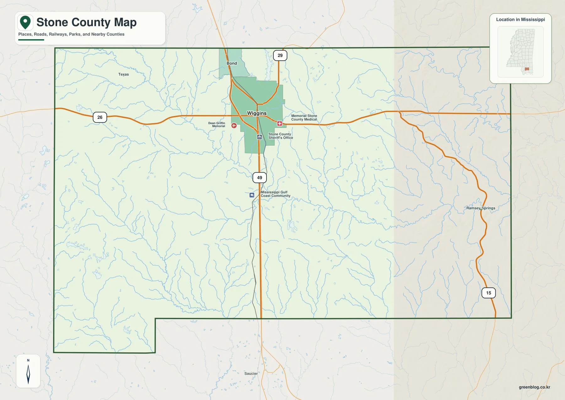
Stone County Mississippi Map files are available to download directly from this page. The supplied views show Wiggins, the county boundary and major roads, the ranked city reference, the water network, and elevation across the inland Gulf Coastal Plain. US 49 provides the clearest north-south orientation through Wiggins, while Red Creek, Black Creek, Black River, and Little Biloxi River occupy lower corridors through the forested landscape. The download ZIP contains the county, city, water, and elevation maps as high-resolution A3 JPG files for printing, editing, classroom use, or location-reference graphics.
Stone County sits north of the immediate Gulf shoreline, so the map is shaped more by pine country, streams, and low rolling terrain than by beaches or coastal water. Wiggins is the obvious settlement anchor, but most of the county is rural and crossed by a dense network of small tributaries. Red Creek cuts across the interior, Black Creek and related streams occupy the east, and higher hills rise above many of those valleys in the west and north-central area. Reading the road, water, and elevation maps together gives a more useful picture than describing the county only as part of the coastal plain.
Table of Contents
Quick Facts
The Census figures supplied in the package list 18,333 residents in the 2020 census and a July 2025 estimate of 19,654. These values use different reference dates and methods, so they are best treated as separate benchmarks rather than identical measurements taken several years apart. Stone County’s FIPS code is 28131, and Wiggins is the county seat.
The supplied 2025 Gazetteer values list 445.485 square miles of land and 2.592 square miles of water. Using the 2020 population and that land area gives about 41.2 residents per square mile, but that is only a countywide average. Settlement is much more concentrated around Wiggins and the US 49 corridor than across the broad forest, creek valleys, and rural road network that fill the rest of the county.
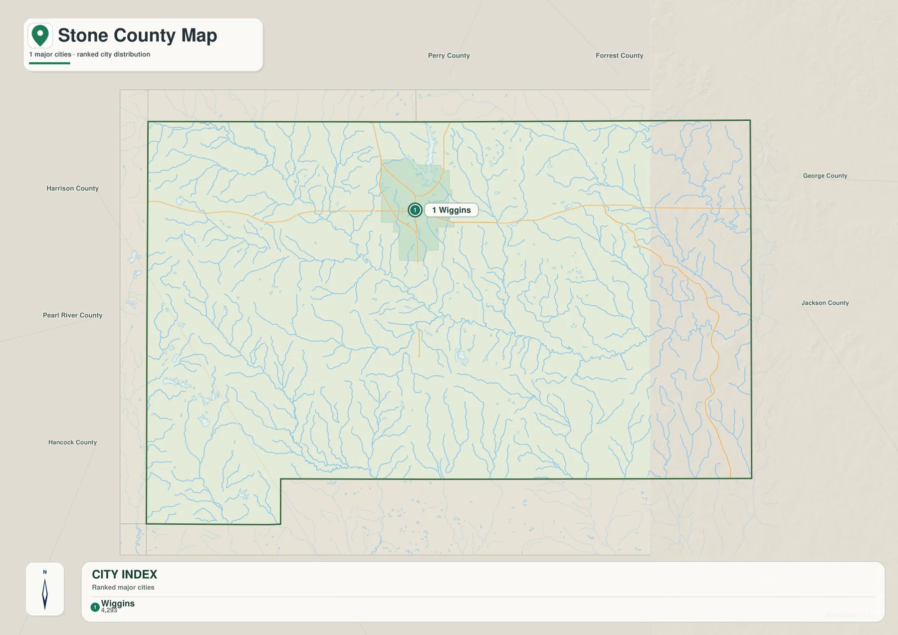
The city map is unusually simple because it ranks only one major city: Wiggins, shown at 4,293 residents in the supplied index. That makes the page different from county maps with several ranked urban centers. The general map adds other place and facility references, including Bond, Ramsey Springs, Mississippi Gulf Coast Community College, Memorial Stone County Medical Center, and the Stone County Sheriff’s Office. These labels help position the main settlement without suggesting that the county is densely urbanized.
Reading the Stone County Mississippi map
US 49 is the strongest road reference on the general county map. It passes directly through Wiggins and continues north toward Forrest County and south toward Harrison County. MS 26 crosses the same city from west to east, providing the clearest route toward Pearl River County on one side and George County on the other. Near Bond, MS 29 supplies another north-south reference for the northeastern portion of Stone County and the approach toward Perry County.
MS 15 is visible close to the eastern county edge and serves a different part of the map from US 49. It does not run through central Wiggins, so it is more useful for understanding the Ramsey Springs and George County side. The map intentionally simplifies forest roads, small rural lanes, and local access routes. It is therefore best for county-scale orientation rather than turn-by-turn navigation or current road-condition decisions.
Wiggins itself is compact relative to the full county. The general map places the hospital and sheriff’s office close to the US 49-MS 26 area, while Mississippi Gulf Coast Community College is labeled farther south along the US 49 corridor. Beyond the city, road labels thin out and blue stream lines become far more common. That contrast gives a clear sense of Stone County as a county with one strong administrative center surrounded by extensive rural forest and drainage country.
Boundary, Water, and Terrain
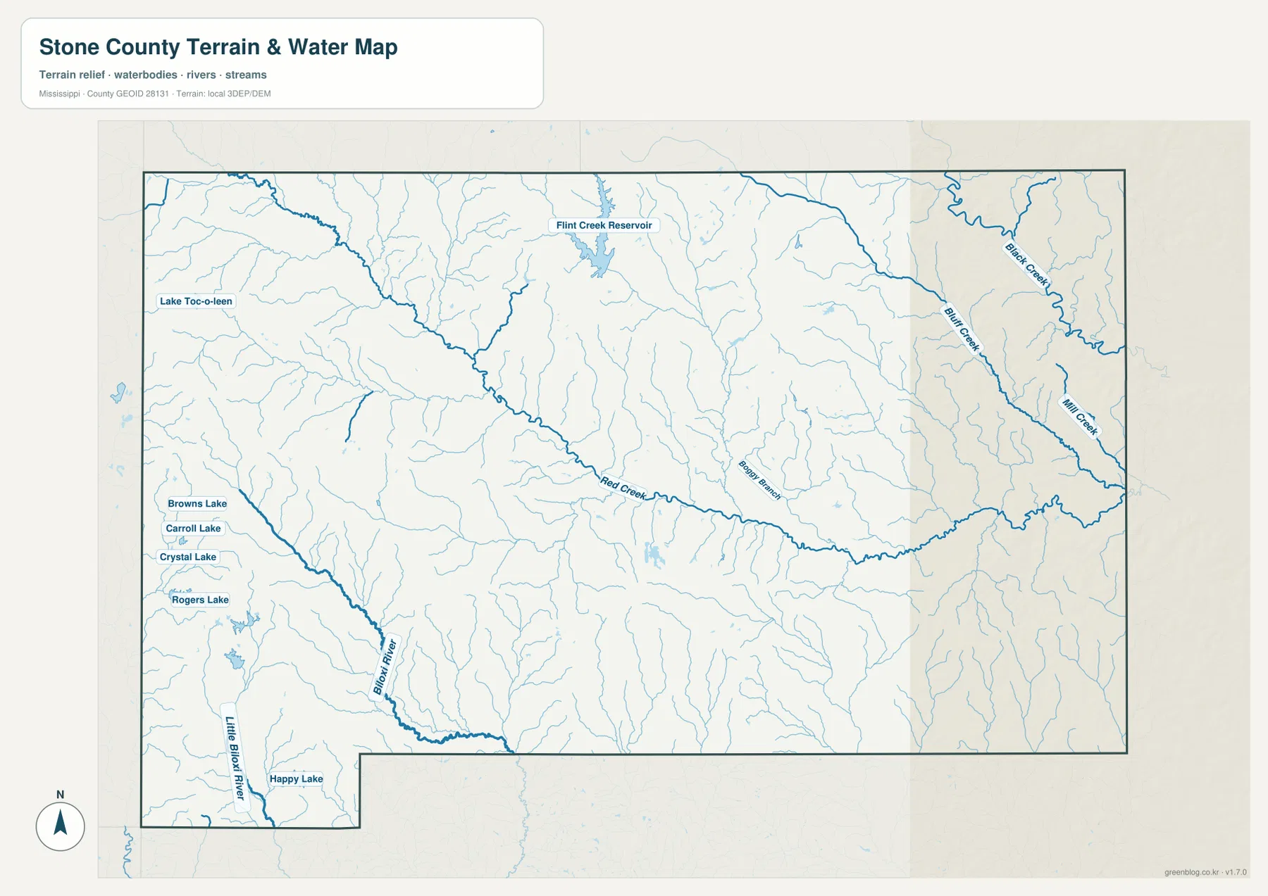
Red Creek is one of the most prominent waterways on the terrain-and-water map. It crosses the county on a long diagonal and collects many smaller tributaries along the way. Black Creek winds through the northeastern side close to the county boundary, while Bluff Creek and Mill Creek form separate drainage corridors farther south. Bearry Branch is labeled near the center, reinforcing how densely the larger streams are connected to small channels.
The southwestern part of the map belongs to another drainage pattern. Black River is labeled as a strong channel there, while Little Biloxi River runs even farther west near the lower county extension. This means Stone County cannot be described accurately through one signature creek alone. Red Creek, Black Creek, Black River, and Little Biloxi River occupy different parts of the county and together explain why the terrain is cut into many separate low corridors.
Several named lakes and reservoirs add useful reference points. Flint Creek Reservoir stands out in the north-central area, and Lake Toc-o-leen is labeled on the west side. Browns Lake, Carroll Lake, Crystal Lake, and Rogers Lake are grouped in the southwest, while Happy Lake appears near the southern edge. The pattern is one of scattered inland water bodies rather than a single enormous lake dominating the county.
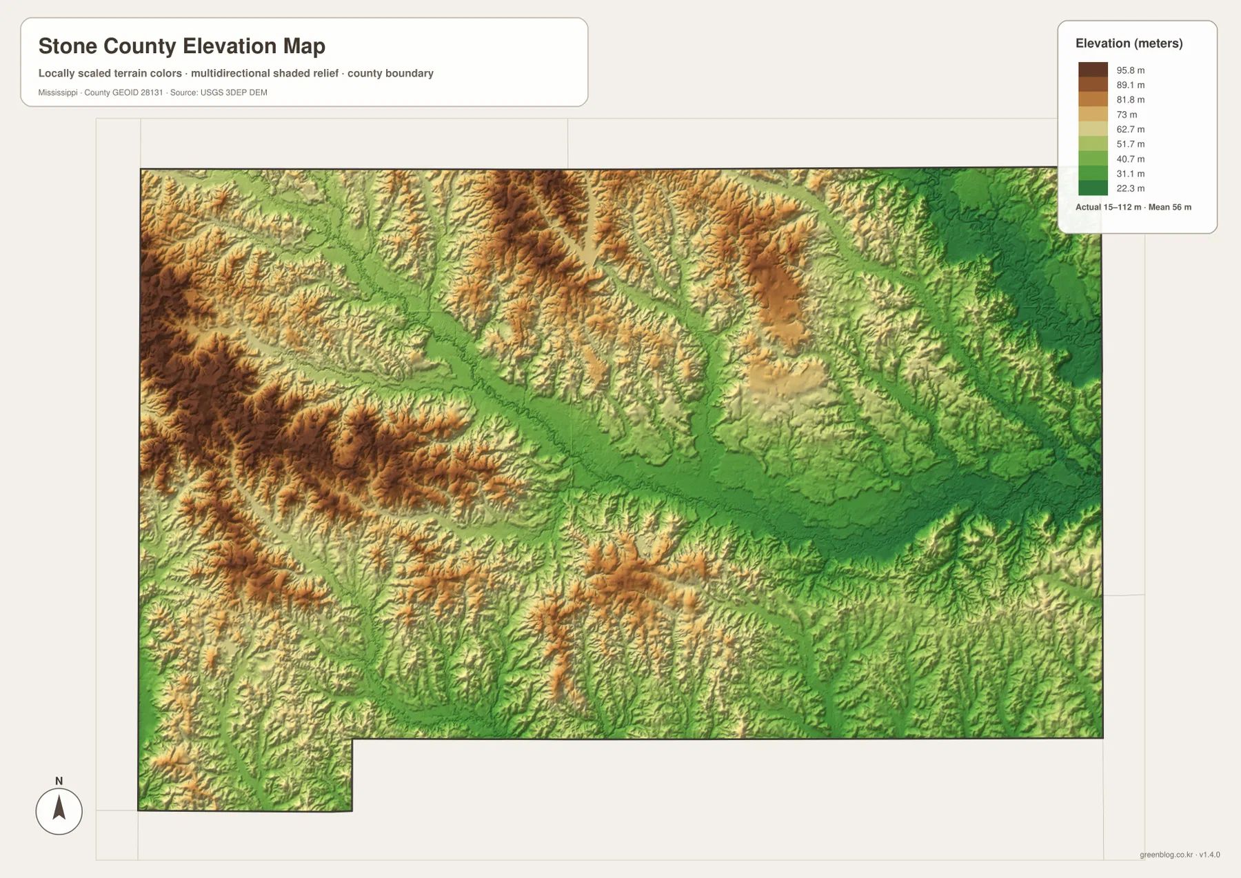
The elevation map prints an actual range of about 15 to 112 meters and a mean elevation of about 56 meters. Higher brown and orange ridges are most noticeable in the west and north-central parts of the county. A broad green low corridor crosses the middle, and the eastern and northeastern drainage country is generally lower. The south is also fairly low overall, although short ridges remain between stream valleys. Stone County is therefore low compared with mountainous terrain, but it is not perfectly flat.
Comparing the water and elevation maps makes the relationship easy to see. Red Creek follows a broad lower corridor, and Black Creek, Bluff Creek, and Mill Creek also occupy valleys below nearby ridges. Even in the hillier west, small tributaries cut green channels through the higher terrain. The elevation surface is generalized for county-scale comparison and should not be used as survey data for a property, drainage design, construction decision, or flood-risk determination.
Settlement and Regional Context
Wiggins is the county seat and the clearest settlement reference on every map. Its location at the US 49 and MS 26 crossing makes it useful for explaining movement toward Forrest County, Harrison County, George County, and Pearl River County. The supplied existing material describes Wiggins as a courthouse, retail, and national-forest service center, and the general map reinforces that role by placing medical and law-enforcement facilities in the city area.
Perkinston lies south of Wiggins on the broader US 49 corridor and is identified in the existing source material with the Mississippi Gulf Coast Community College campus. McHenry is another southern reference toward Harrison County, while Bond marks the northern side of the Wiggins area. These places are more useful as route and regional anchors than as a list of large cities, which fits a county where the ranked city map shows only Wiggins.
De Soto National Forest and Black Creek are central to the county’s natural setting in the supplied material. The existing article connects the area with pine country, Black Creek and Red Creek, and low Gulf Coastal Plain wetlands. The water and elevation maps support that broad description by showing stream valleys repeatedly cutting through rolling forest terrain. These maps do not show legal forest ownership boundaries, so precise management areas should be checked with the U.S. Forest Service rather than inferred from the county outline.
Practical Map Uses
Use the general county map when the boundary, Wiggins, US 49, MS 26, and nearby route references need to appear together. The city map is useful when Wiggins itself should be emphasized without the extra road detail. Choose the water map for Red Creek, Black Creek, Black River, Little Biloxi River, and the named lakes. The elevation map is the clearest option for showing the contrast between lower creek valleys and the higher hills in the west and north-central part of the county.
For classroom or presentation work, pairing the road map with the elevation map connects Wiggins and the main transportation corridors with the land underneath. For a natural-landscape explanation, the water and elevation views are stronger together: one identifies the named streams and lakes, while the other shows the low corridors those waterways follow and the ridges between them.
The WebP images on the page are optimized as previews. The high-resolution JPG originals in the archive are more suitable for printing and editing. These maps are general geographic references, not parcel surveys, engineering drawings, flood maps, boating-access guides, or live navigation products, so specialized current sources are still required for property, construction, flood, water-access, or real-time travel decisions.
Frequently Asked Questions
Does Stone County touch the Gulf of Mexico?
No. Harrison County lies to the south, making Stone an inland coastal-plain county. US 49 provides the main Gulf Coast approach.
How does De Soto National Forest complement Wiggins when orienting the map toward Perry?
A symbol at Wiggins fixes one named point; De Soto National Forest adds a broader frame that can be followed toward Perry without treating every local road as mapped.
Map File Information
The ZIP contains the Stone County county, city, water, and elevation maps as high-resolution A3 JPG files. These originals are larger than the WebP page previews and are suitable for printing, editing, classroom materials, or location-reference graphics.
- File Type: four high-resolution JPG files in one ZIP
Related Maps
Sources
- U.S. Census Bureau QuickFacts for Stone County — population reference
- U.S. Census Bureau Gazetteer Files — land and water area reference
- Mississippi Department of Transportation Official Highway Map — US 49, MS 26, and state-route reference
- U.S. Forest Service Black Creek National Wild and Scenic River — Black Creek and De Soto National Forest regional reference
- USGS National Hydrography — river, creek, and waterbody reference
- USGS 3D Elevation Program — elevation and terrain reference
Green Map creates custom-edited map images using open geographic data sources such as geoBoundaries, Natural Earth, OpenStreetMap, and government open data. These maps are edited visual materials, not raw data files, and are provided for education, documents, presentations, and graphic reference.