Simpson County Mississippi Map files are available to download directly from this page. The supplied views cover the county boundary and roads, selected city connections, water features, and elevation, with Mendenhall, Magee, D’Lo, and Braxton providing the clearest place references. US 49 is the main north-south route, while Strong River, Big Creek, Georgetown Creek, Okatoma Creek, and numerous smaller channels divide the wooded terrain. The download ZIP contains all four maps as high-resolution A3 JPG files for printing, editing, classroom use, or location-reference graphics.
The county is easier to read when Mendenhall and Magee are treated as different kinds of reference points rather than interchangeable centers. Mendenhall is the county seat, while Magee is the largest place shown on the city-connections map and sits farther south on the US 49 corridor. D’Lo and Braxton help orient the northern side. To the west, lower stream valleys occupy broad green terrain, while the east and southeast contain higher, more closely spaced hills. The road, water, and elevation maps make those differences visible without forcing every feature into a single crowded graphic.
Table of Contents
Quick Facts
The Census figures supplied in the package list 25,949 residents in the 2020 census and a July 2025 estimate of 25,498. These values use different reference dates and methods, so they are better treated as separate benchmarks than as identical measurements taken several years apart. Simpson County’s FIPS code is 28127, and Mendenhall is the county seat.
The supplied 2025 Gazetteer values list 589.165 square miles of land and 1.304 square miles of water. Using the 2020 population and that land area gives roughly 44 residents per square mile, but this is only a countywide average. People are not evenly spread among Mendenhall, Magee, small communities, farms, forested hills, and stream valleys, so the map is more useful than a single density number for understanding where settlement is concentrated.
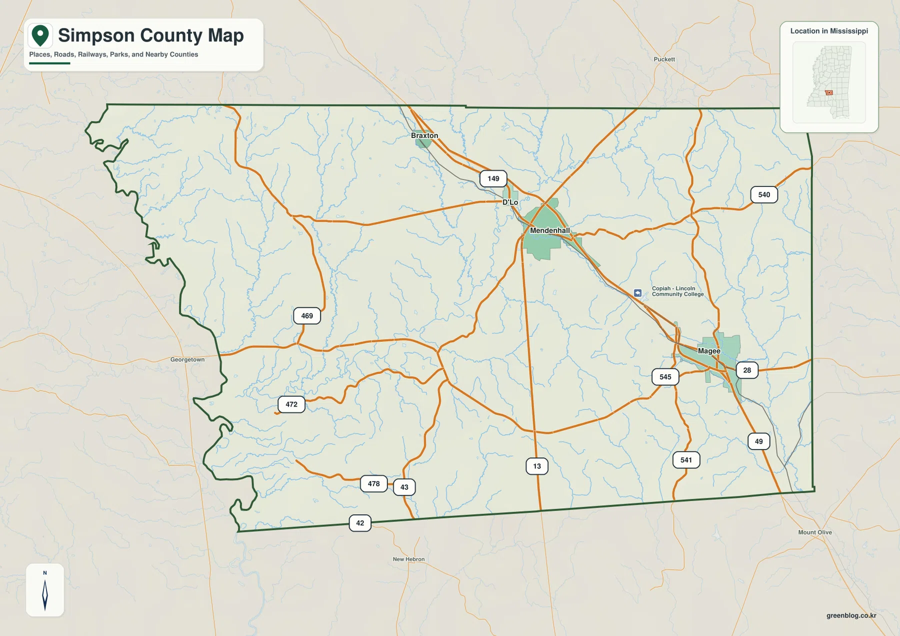
The most prominent place labels on the supplied maps are Mendenhall, Magee, D’Lo, and Braxton. The existing article identifies US 49, MS 13, MS 28, and MS 149 as primary route references, while the general county map also labels MS 42, 43, 469, 472, 478, 540, 541, and 545. A reader does not need to memorize all of them. Starting with US 49 and the Mendenhall-Magee relationship makes the rest of the network much easier to follow.
Reading the Simpson County Mississippi map
US 49 is the strongest road reference on the general county map. It enters from the Rankin County direction, passes the Mendenhall area, continues through Magee, and heads south toward Covington County. Around Mendenhall, MS 13 provides a north-south local reference and MS 149 connects toward D’Lo and Braxton. Around Magee, MS 28 and several state routes spread east and west, creating a denser road pattern in the southern city area.
The western half looks less urban and more strongly shaped by local roads and drainage. MS 469 and MS 472 cross the west, with MS 478 and MS 43 farther south and MS 42 near the lower edge. MS 540 appears on the eastern side, while MS 541 and MS 545 help define the road pattern around Magee. This arrangement is better understood as a long US 49 corridor with several local branches than as a county where every route converges on one downtown.
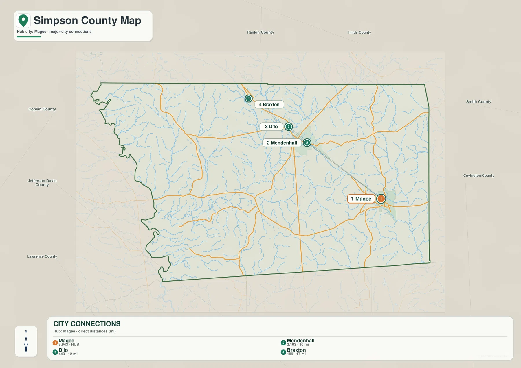
The city-connections map simplifies that picture. Magee is the hub, Mendenhall is labeled about 10 miles away, D’Lo about 12 miles, and Braxton about 17 miles by straight-line distance. These are direct map distances, not driving mileage. The same index lists Magee at 3,943 residents, Mendenhall at 2,103, D’Lo at 443, and Braxton at 189, which provides a quick comparison of the selected communities without substituting for the countywide population.
Boundary, Water, and Terrain
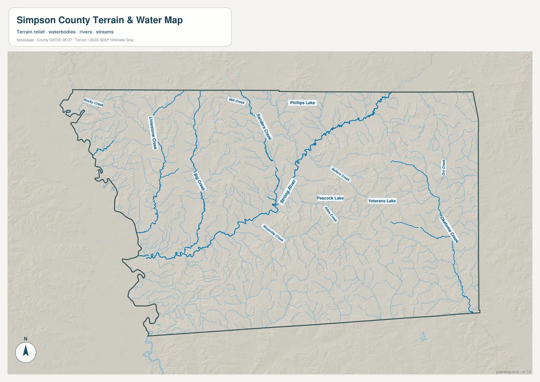
Strong River is the most prominent named waterway on the supplied terrain-and-water map. It crosses the central part of the county on a diagonal and gathers water from a broad set of tributaries. Big Creek and Limestone Creek are visible to the west, Georgetown Creek and Weathers Creek lie closer to the center, and Rocky Creek and Mill Creek appear farther north. On the eastern side, Sellers Creek, Rials Creek, and Dry Creek add more separate drainage lines.
Okatoma Creek is labeled near the southeastern edge and provides a useful reference for the eastern drainage side. Several small lakes are also marked: Phillips Lake is near the north, Peacock Lake lies in the central-east, and Veterans Lake is farther east. The county is therefore not defined by one large reservoir. Its water pattern comes from many creeks and short valleys spread between wooded ridges.
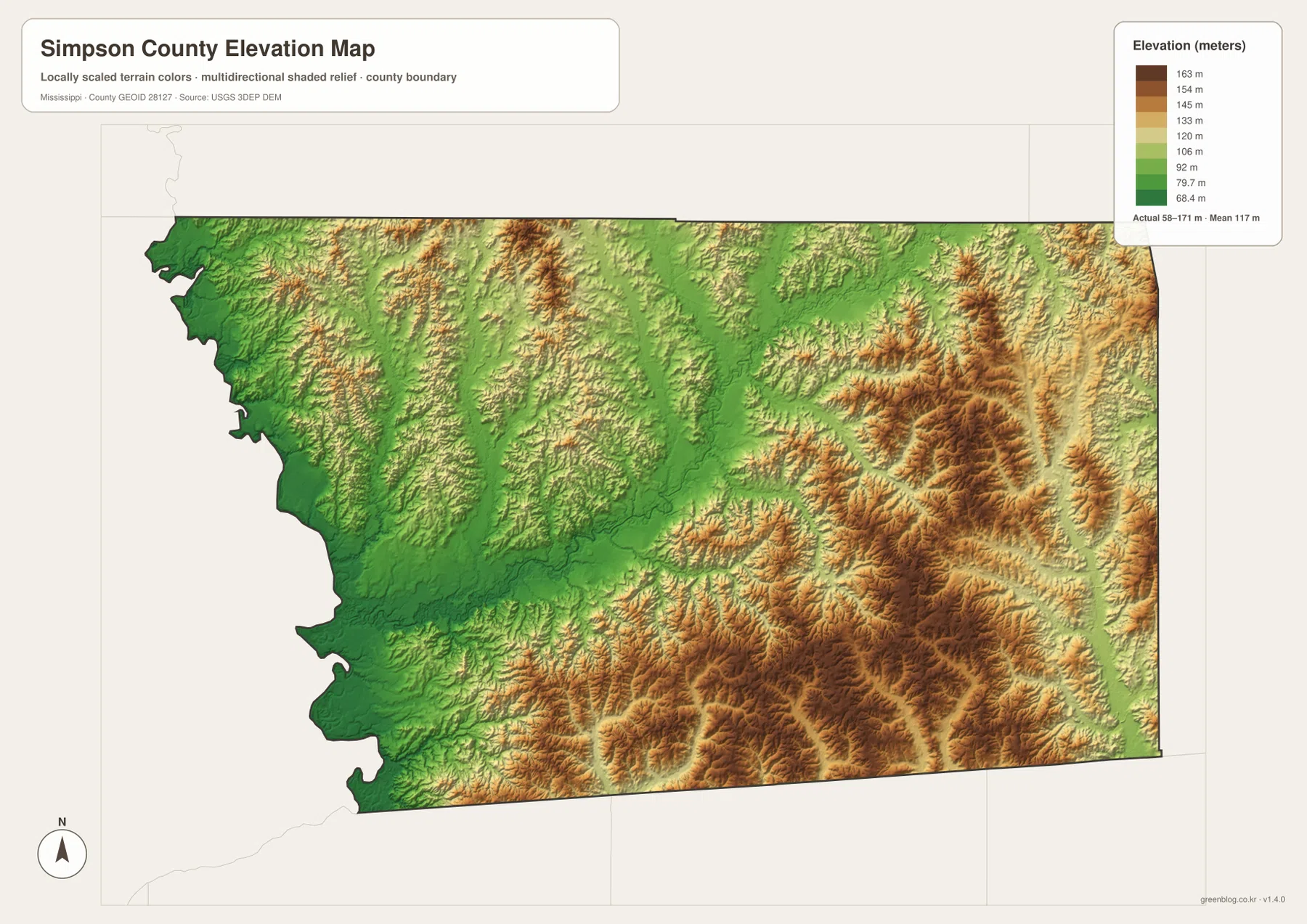
The elevation map prints an actual range of about 58 to 171 meters and a mean of about 117 meters. Lower green terrain is broadest in the west and northwest, where Strong River and its tributaries occupy long valleys. Moving south and east, tan and brown hills become more common. The eastern and southeastern sections contain the strongest ridge texture, creating a clear contrast with the lower western drainage country.
Comparing the water and elevation views explains the pattern. Strong River and Big Creek follow lower corridors, while the Okatoma Creek side is cut by narrow valleys between higher hills. The elevation surface is generalized for county-scale comparison and should not be used as survey data for a building site, road grade, drainage design, or construction decision. Its role here is to show the broad difference between stream valleys and the higher wooded hill country.
Settlement and Regional Context
Mendenhall is the county seat and is the natural administrative reference for the county. The general map places it just west of the US 49 line with several state routes branching around the city. D’Lo and Braxton lie farther north and northwest. Magee occupies a different position farther south, where US 49 meets a denser set of roads and where the city-connections map gives the largest selected population figure.
Copiah-Lincoln Community College is also labeled between the Mendenhall and Magee sides of the general map. The label is useful as a location reference, but the map is not intended to show the precise campus boundary. The corridor between the two cities is not one continuous urban strip; it includes rural roads, streams, wooded land, and open country between settlement areas.
The existing article describes pine-covered hills as an important landscape reference, and that wording fits the elevation map particularly well in the east and southeast. The county therefore makes more sense when the road corridor is combined with the physical setting: lower Strong River country lies to the west, while higher wooded ridges become increasingly prominent toward the eastern and southern sides.
Practical Map Uses
Use the general county map when the boundary, US 49, Mendenhall, Magee, and several state routes need to appear together. The city-connections map is better for comparing Magee with Mendenhall, D’Lo, and Braxton and for using the printed straight-line distances. Choose the water map when Strong River, Big Creek, Georgetown Creek, Okatoma Creek, or the small lakes are the main subject. The elevation map is the clearest option for showing why the west is lower while the east and southeast contain stronger hill relief.
For a classroom or presentation, the road and elevation maps make a useful pair because they connect settlement and transportation with the terrain underneath. For a natural-landscape explanation, the water and elevation maps work better together. One identifies the named drainage lines, while the other shows the lower valleys and higher ridges around them.
The WebP images on the page are optimized as previews. The high-resolution JPG originals in the archive are more suitable for printing and editing. These maps are general geographic references, not parcel surveys, engineering drawings, flood-risk maps, or live navigation products, so specialized current sources are still required for property, construction, flood, or real-time travel decisions.
Frequently Asked Questions
Is Magee the county seat?
No. Mendenhall is the county seat. Magee is a larger southern commercial and medical center, so the two cities have different map functions.
Why compare Strong River with Mendenhall before reading the side toward Rankin?
Mendenhall is a settlement anchor, while Strong River supplies a physical reference for separating the county interior from the approach to Rankin.
Map File Information
The ZIP contains the Simpson County county, city, water, and elevation maps as high-resolution A3 JPG files. These originals are larger than the WebP page previews and are suitable for printing, editing, classroom materials, or location-reference graphics.
- File Type: four high-resolution JPG files in one ZIP
Related Maps
Sources
- U.S. Census Bureau QuickFacts for Simpson County — population reference
- U.S. Census Bureau Gazetteer Files — land and water area reference
- Mississippi Department of Transportation Official Highway Map — US 49 and state-route reference
- USGS National Hydrography — Strong River, creeks, and waterbody reference
- USGS 3D Elevation Program — elevation and terrain reference
- Simpson County regional information — local institution and county reference
Green Map creates custom-edited map images using open geographic data sources such as geoBoundaries, Natural Earth, OpenStreetMap, and government open data. These maps are edited visual materials, not raw data files, and are provided for education, documents, presentations, and graphic reference.