You can download four high-resolution A3 JPG maps of Lubbock County, Texas, in one ZIP directly from this page. The package contains a general county map, a ranked city map, a terrain-and-water map, and an elevation map. Together they show Lubbock, Wolfforth, Slaton, Shallowater, Idalou, Ransom Canyon, major numbered roads, the Yellow House and Blackwater drainage system, several named lakes, and an actual elevation range of about 855 to 1,049 meters.
Lubbock is the natural starting point because its urban area fills a large part of the south-central county. Roads radiate north toward New Deal and Abernathy, northwest toward Shallowater, west and southwest toward Wolfforth, east toward Idalou, and southeast toward Slaton. The road map can look almost grid-like around the city, but the physical landscape changes sharply on the eastern side. Buffalo Springs Lake, Ransom Canyon, and the Yellow House drainage occupy a much more deeply cut corridor that becomes especially obvious on the water and elevation maps.
Table of Contents
Lubbock’s urban core is surrounded by roads leading to smaller communities
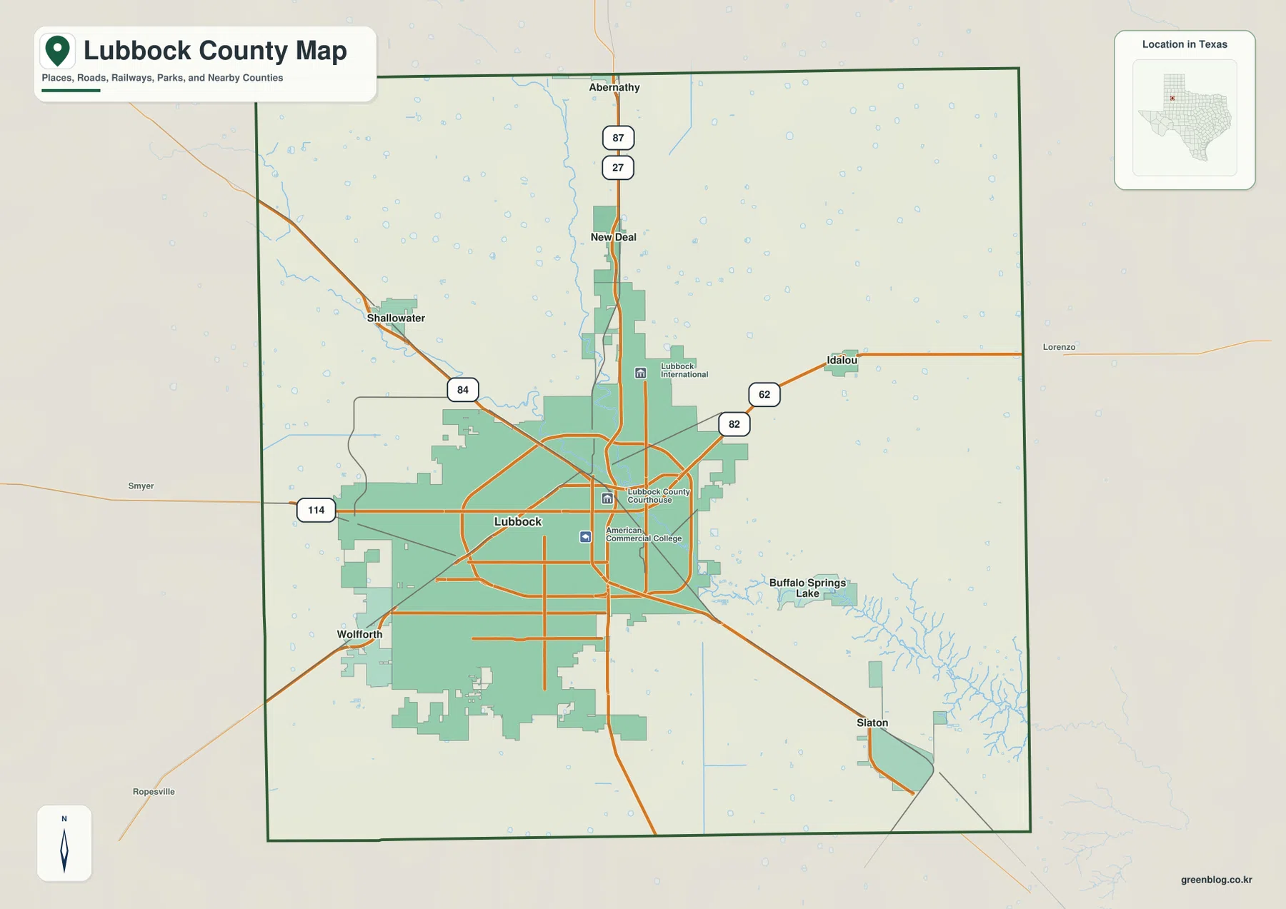
The general county map gives Lubbock the strongest visual presence. Its developed area spreads broadly across the lower middle of the county, and several orange road lines cross or loop around it. Routes 87 and 27 run north from the city toward New Deal and then the Abernathy area near the county line. Lubbock International Airport is labeled northeast of the main city area, while the Lubbock County Courthouse marker provides a separate reference closer to the center.
To the northwest, Shallowater lies near Route 84. Route 114 approaches the city from the west, while roads marked 62 and 82 are visible on the eastern side toward Idalou. These corridors do not all converge at one single point; they spread through different sides of the urban area. That pattern makes it useful to treat Lubbock as a broad city zone rather than a small dot when judging the direction of surrounding communities.
Wolfforth sits immediately southwest of Lubbock and appears closely tied to the larger urban footprint. Slaton is more clearly separated in the southeast. Buffalo Springs Lake is labeled east of Lubbock, close to the beginning of the highly dissected terrain that continues toward Ransom Canyon and the southeastern boundary. The contrast between straight road corridors and the irregular water-cut landscape is one of the most distinctive features on the general map.
The city index shows how strongly Lubbock dominates the settlement pattern
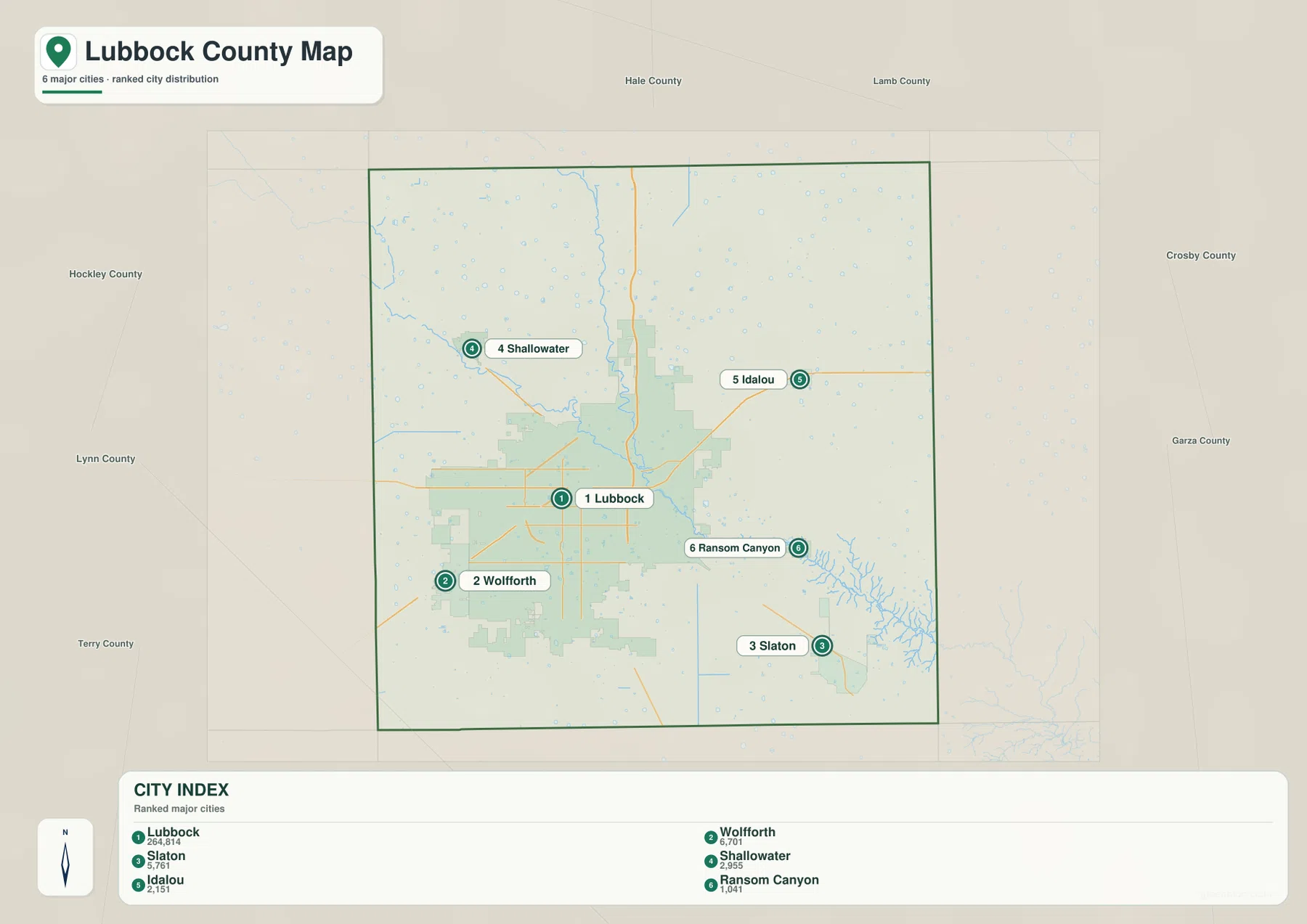
The ranked city map highlights six major communities. Lubbock is number 1, Wolfforth number 2, Slaton number 3, Shallowater number 4, Idalou number 5, and Ransom Canyon number 6. The map also prints numerical values beside the names in the lower index. Because the supplied image does not identify a year for those figures, they are best treated as values shown by the map rather than automatically presented as current population counts.
The spatial pattern matters more than the ranking alone. Lubbock occupies the broad center-south urban area, while Wolfforth is immediately southwest. Shallowater sits northwest, Idalou east, and Slaton southeast. Ransom Canyon lies east-southeast of the main city, close to the branching drainage terrain. The six markers therefore surround one dominant urban center rather than forming a straight line of similarly sized towns.
Hale, Lamb, Crosby, Garza, Lynn, Terry, and Hockley counties are labeled around the outside of the simplified map for regional orientation. The city map is useful when the goal is simply to compare settlement direction and spacing. When Route 84, Route 114, the airport, or Buffalo Springs Lake needs to be located, the more detailed general county map is the better reference.
Yellow House River and Blackwater Draw converge toward the southeast
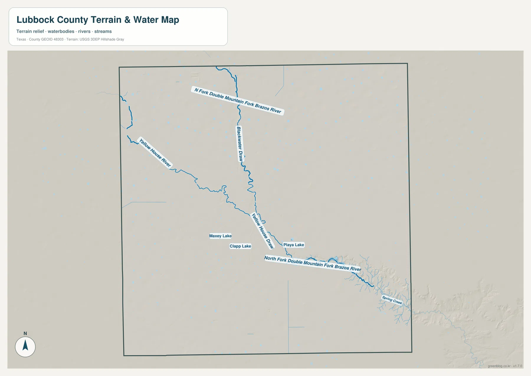
The terrain-and-water map changes the emphasis completely. Blackwater Draw enters from the north-central part of the county and runs south, while Yellow House River approaches from the northwest and bends toward the same central drainage corridor. Yellow House Draw is labeled farther downstream. Their combined path continues toward the southeast, where the valley becomes increasingly complex and deeply branched.
North Fork Double Mountain Fork Brazos River is labeled across the northern portion and again along the major southeastern channel. The supplied water view makes the relationship between that system and the Yellow House drainage much easier to see than the road map does. What appears as a modest set of blue lines near the city becomes a large incised drainage network close to the southeastern county edge.
Maxey Lake and Clapp Lake are labeled near one another south of the central drainage, and Playa Lake appears slightly farther east. Spring Creek is labeled close to the southeastern boundary. These smaller features provide useful local references around the Lubbock urban area and the transition into the canyon-like terrain to the southeast.
This layer is intended for geographic reference. It is useful for locating the Yellow House River, Blackwater Draw, named lakes, and the larger downstream channels, but it is not a flood-hazard map, parcel-boundary map, legal water-boundary product, or navigation chart. For roads and towns, match the same location back to the general map.
High western plains drop into the deeply cut southeastern drainage
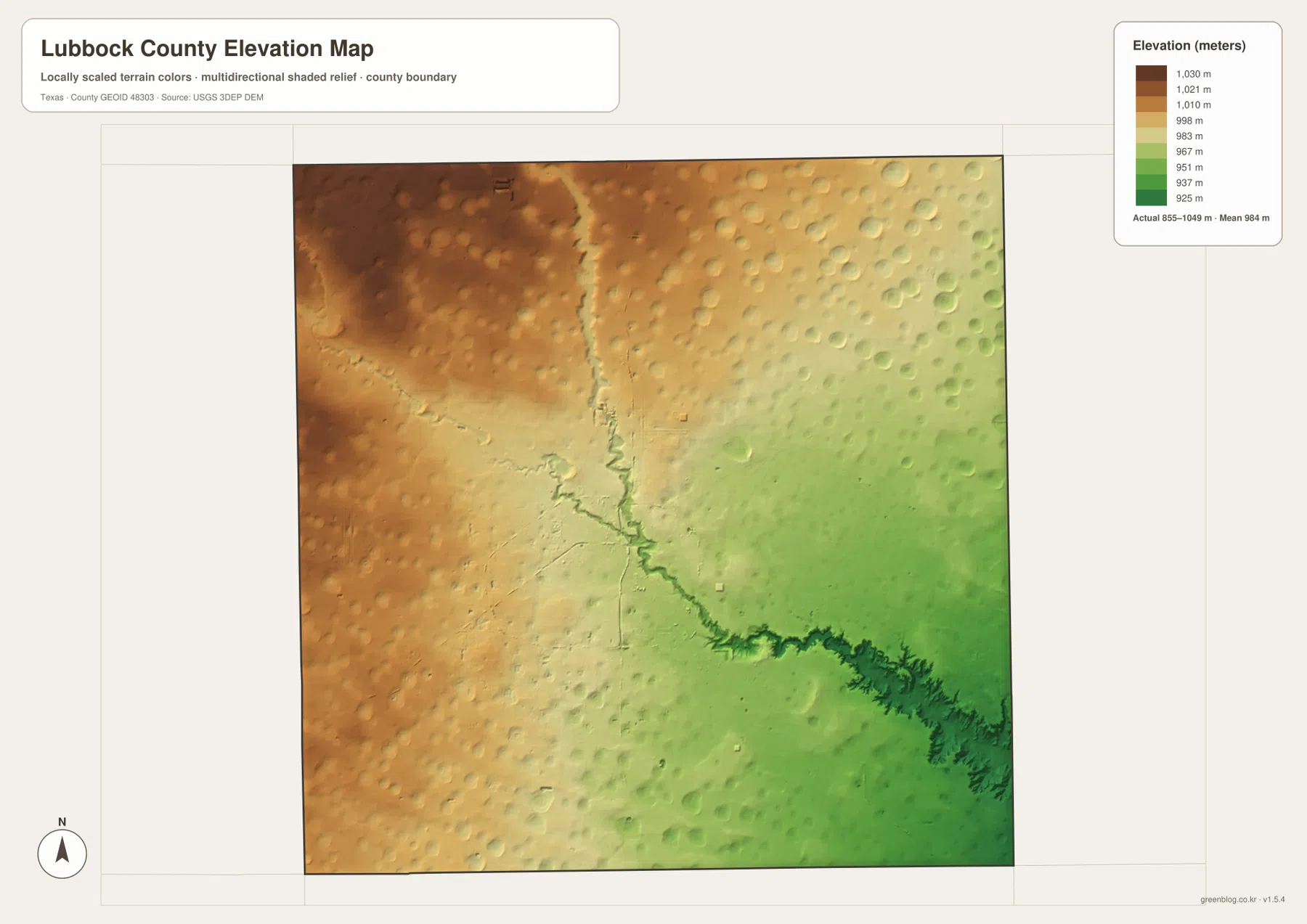
The elevation map reports an actual range of about 855 to 1,049 meters and a mean elevation of about 984 meters. Browns and dark tans dominate the northwest and much of the western side, where the broad surface is higher. The map becomes progressively greener toward the east and southeast, with the lowest terrain concentrated around the major downstream valley.
A narrow lower corridor begins near the north-central part of the county and extends toward the southeast. This line closely matches Blackwater Draw and the Yellow House drainage on the water map. The valley deepens and branches dramatically near the southeastern edge, where shaded relief produces steep-looking fingers and side channels. The surrounding higher surface remains comparatively smooth, which makes the drainage incision stand out even more strongly.
The difference between the displayed minimum and maximum elevation is about 194 meters. The county therefore does not simply tilt gently from west to east. A broad high surface dominates much of the west and northwest, but the Yellow House system cuts a distinctly lower path through it. East and southeast of Lubbock, the relief changes much more rapidly than the straight road network would suggest.
The elevation image is best used for relative terrain comparison rather than survey-grade or engineering-grade measurement. When paired with the city map, it helps explain why Ransom Canyon and the Buffalo Springs area occupy a different physical setting from Wolfforth or Shallowater. When paired with the water map, it shows how the named draws and rivers follow the lowest parts of the landscape.
The change from Lubbock’s street grid to Ransom Canyon is easiest to see across multiple maps
Start with Lubbock on the general map and move east toward Buffalo Springs Lake and Ransom Canyon. The road map shows a transition from the dense urban street pattern into a much more irregular landscape. On the water map, the Yellow House system becomes the dominant feature, and the elevation map shows the same corridor as a deeply incised green valley. The three views describe the same eastward change from city to canyon terrain.
The western side provides the contrast. Wolfforth and Shallowater are linked to Lubbock by relatively straight roads across a broad high surface. The elevation map remains mostly brown and tan there, and the water map shows fewer dramatic drainage cuts than in the southeast. That difference helps explain why the county can look highly regular around its western roads while becoming visually rugged only a short distance east of the main city.
Use the ranked city map when settlement direction is the main question, the general map when road numbers and additional landmarks matter, the terrain-and-water map for named rivers, draws, lakes, and creeks, and the elevation map for the high-plains-to-southeast-valley contrast. Small labels are easier to inspect in the downloadable high-resolution JPG files than in the browser previews.
Frequently Asked Questions
Which communities are ranked on the Lubbock County city map?
The map ranks Lubbock first, Wolfforth second, Slaton third, Shallowater fourth, Idalou fifth, and Ransom Canyon sixth. Lubbock occupies the large south-central urban area, while the other five communities are distributed around it in different directions.
Which water features are easiest to identify?
Yellow House River and Blackwater Draw are the main central references. Yellow House Draw and North Fork Double Mountain Fork Brazos River continue the drainage toward the southeast. Maxey Lake, Clapp Lake, Playa Lake, and Spring Creek are also labeled on the supplied map.
What elevation range is shown for Lubbock County?
The supplied elevation map reports an actual range of about 855 to 1,049 meters and a mean of about 984 meters. The west and northwest are generally higher, while the Yellow House drainage and southeastern canyon terrain are lower.
Sources and Reference Data
- U.S. Census Bureau TIGER/Line Shapefiles — official county-boundary and road geometry for geographic reference.
- USGS National Hydrography — official resources for rivers, draws, lakes, and other water features.
- USGS 3D Elevation Program — official elevation resources used for terrain information.
- USGS The National Map Viewer — an official viewer for comparing multiple geographic layers.
Map File Information
Download four high-resolution A3 JPG maps of Lubbock County in one ZIP file.
- Included Files: county map, ranked city map, terrain and water map, elevation map
- File Type: JPG
Related Maps
- Motley County Texas map
- Swisher County Texas map
- Scurry County Texas map
- Terry County Texas map
- Yoakum County Texas map
Green Map creates custom-edited map images using open geographic data sources such as geoBoundaries, Natural Earth, OpenStreetMap, and government open data.
These maps are edited visual materials, not raw data files, and are provided for education, documents, presentations, and graphic reference.