You can download four high-resolution A3 JPG maps of Lynn County, Texas, in one ZIP directly from this page. The package includes a general county map, a Tahoka-centered city-connections map, a terrain-and-water map, and an elevation map. The maps show Tahoka, New Home, Wilson, O’Donnell, roads marked 380, 87, 211, and 84, named lakes including Tahoka Lake, and the Double Mountain Fork Brazos River drainage in the southeast. The elevation layer reports an actual range of about 811 to 1,011 meters.
Tahoka is the best starting point because it sits close to the center of the road network. Route 380 crosses the county from west to east through the Tahoka area, while the road marked 87 provides a strong north-south reference. New Home and Wilson occupy different parts of the north, and O’Donnell lies near the southern boundary. This road-and-town pattern looks fairly simple until the map reaches the southeast, where connected drainage and deeply cut relief replace the scattered small water bodies found across much of the rest of the county.
Table of Contents
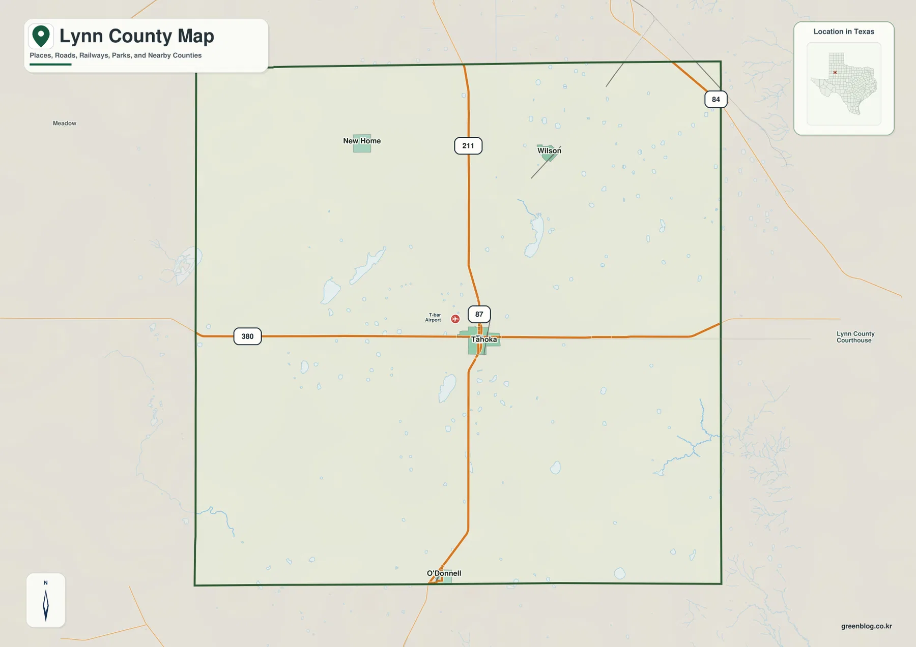
Tahoka gives the road map a clear center
The general map places Tahoka slightly south of the county’s midpoint. Route 380 runs across town and continues toward both county boundaries, making it the easiest east-west line to follow. Route 87 is labeled just north of Tahoka on the main north-south corridor. T-Bar Airport appears close to the northwest side of town and provides another small landmark for locating the urban area.
North of Tahoka, a road marked 211 is visible along the central corridor. New Home sits farther northwest, while Wilson is positioned to the northeast. The two communities are separated by a broad area containing local roads and many small blue water marks rather than a continuous built-up strip. Route 84 is labeled near the northeastern edge beyond the main county interior and provides an additional regional road reference.
O’Donnell is near the southern boundary and sits almost directly south of Tahoka on the map. The distance between those two places makes the county’s north-south scale easy to judge. The southeastern corner looks different from this central road corridor: blue drainage lines become denser and the terrain grows more irregular, a change that is much clearer on the water and elevation maps.
The city-connections map shows three different directions from Tahoka
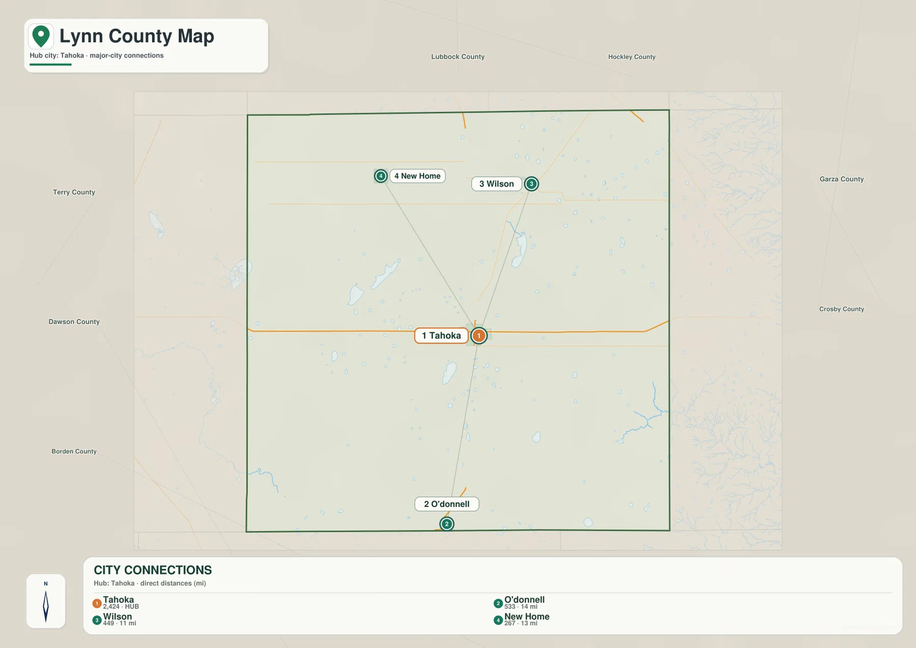
The simplified city map uses Tahoka as the hub and draws direct connections to O’Donnell, Wilson, and New Home. Its distance labels show about 14 miles from Tahoka to O’Donnell, 11 miles to Wilson, and 13 miles to New Home. These are straight-line distances between the mapped points, not road-driving distances, so they are best used to compare relative spacing rather than travel mileage.
The directions are easy to see because most road detail has been removed. O’Donnell is almost due south of the hub, Wilson lies northeast, and New Home lies northwest. The three connection lines spread away from Tahoka rather than following one town corridor. When the general map is placed beside this view, the straight-line geometry can be compared with the actual road network.
Lubbock, Hockley, Terry, Dawson, Borden, Garza, and Crosby counties are labeled around the outside for regional orientation. Those labels help place Lynn County within the surrounding area, but the main value of the city map is simpler: it shows how Tahoka relates to the three mapped communities inside the county and how far apart they are in direct distance.
Tahoka Lake and Hidden Lake sit among many smaller water bodies
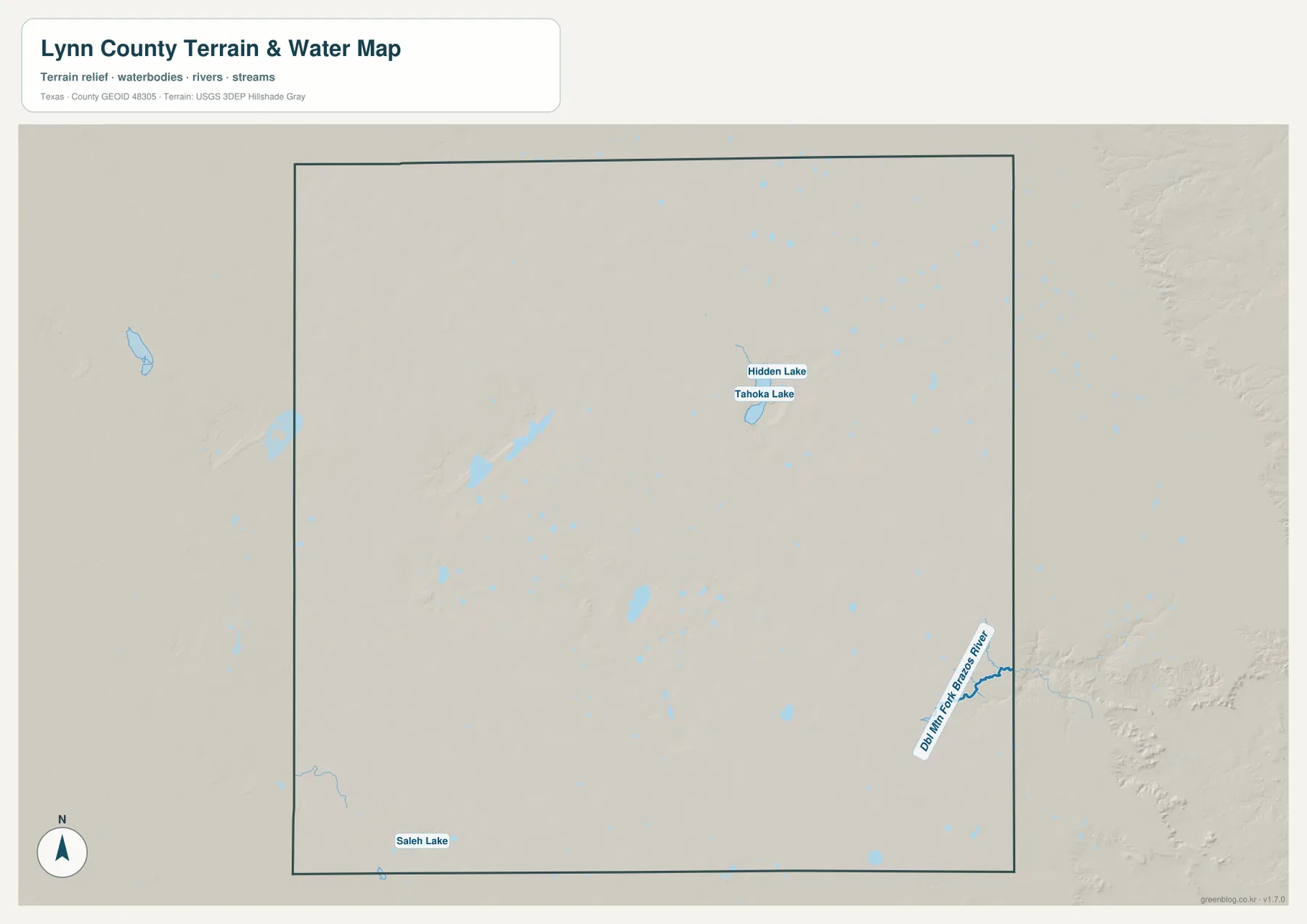
The terrain-and-water map reveals a different side of Lynn County. Tahoka Lake and Hidden Lake are labeled close together in the north-central to northeastern part of the county. Around them, many smaller blue features are scattered across the landscape. Similar small water bodies appear through the north, center, and east, creating a dotted pattern rather than one continuous river network.
Tahoka Lake is not shown immediately beside the Tahoka urban center. On the map it lies farther to the northeast, with Hidden Lake just above it. That separation is useful to remember when switching between the road and water views. Saleh Lake provides another named reference near the southern boundary, well away from the two lakes in the upper half.
Many of the other small blue features are unlabeled in the supplied image, so this article does not assign names to them. Their distribution is still useful because it contrasts sharply with the southeastern corner. Most of the county is characterized by scattered small water bodies, while the southeast contains a connected river-and-tributary system that cuts a much stronger path through the terrain.
Double Mountain Fork Brazos River creates the strongest southeastern drainage
The longest and most clearly connected named water feature is the Double Mountain Fork Brazos River near the southeastern side. It follows a branching, winding corridor close to the county edge, with smaller channels feeding into it. The shape is very different from the isolated lakes and small water marks across the northern and central parts of Lynn County.
The general county map already hints at this change because blue channels cluster in the southeast and the background relief becomes rougher near the boundary. Removing the roads on the water map makes the transition much easier to see. What looks like open space on the road map becomes a network of connected valleys and channels.
This water layer is intended for geographic reference. It can be used to locate Tahoka Lake, Hidden Lake, Saleh Lake, the Double Mountain Fork Brazos River, and visible unnamed water bodies relative to the county boundary. It should not be used as a flood-hazard map, legal water-boundary product, parcel map, or navigation chart.
High western ground gives way to a much lower southeastern valley
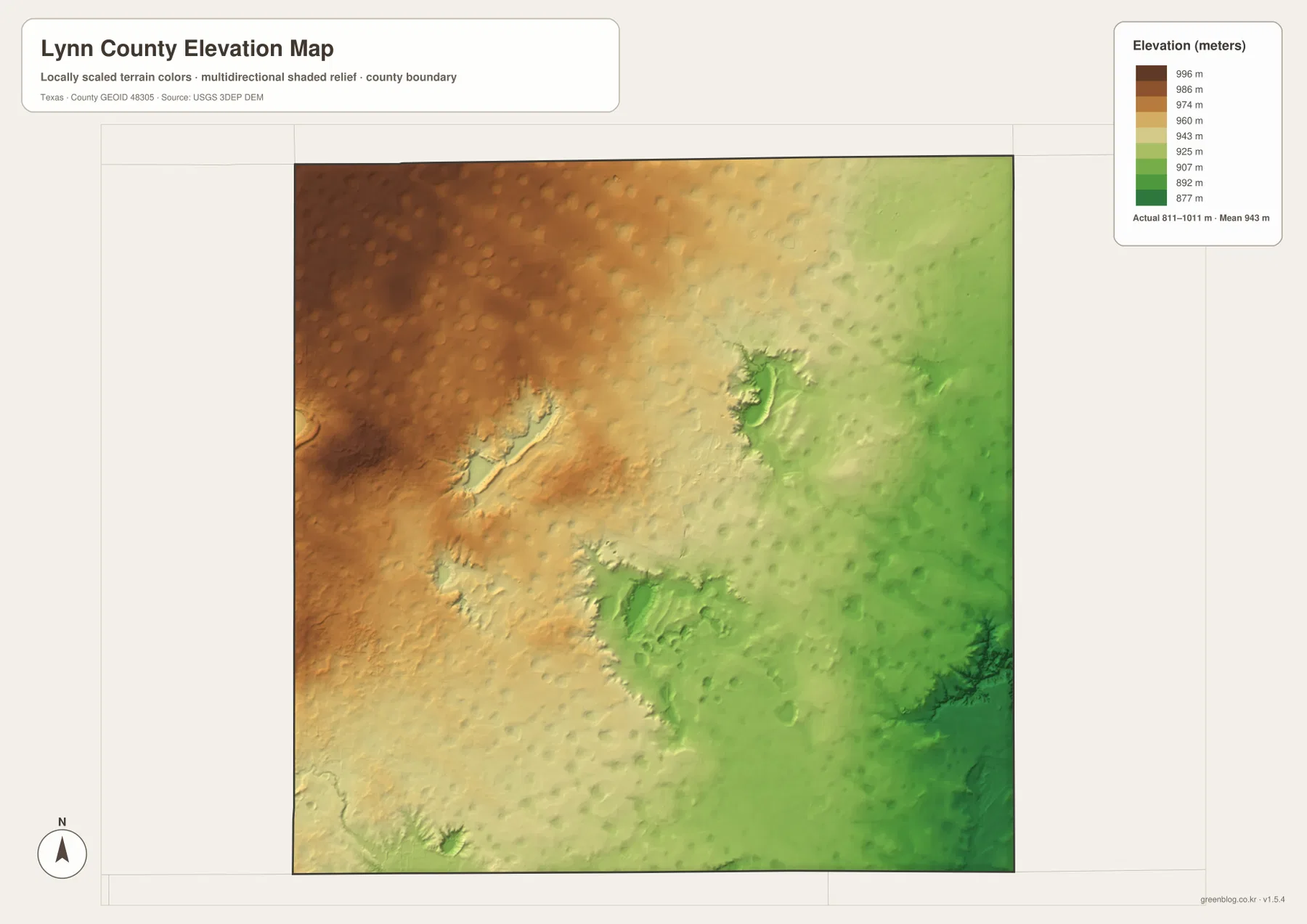
The elevation map reports an actual range of about 811 to 1,011 meters and a mean elevation of about 943 meters. The western and northwestern parts are dominated by brown and dark tan colors, indicating higher ground. Moving east, the colors shift through yellow and light green. The southeast contains the lowest and most deeply incised green terrain on the map.
Several rounded or elongated depressions also appear in the central and eastern interior. Some correspond broadly with areas where the water map shows clusters of small lakes. The southeast is different in scale: the lower terrain becomes a branching corridor rather than an isolated basin, matching the Double Mountain Fork Brazos River system.
The difference between the displayed minimum and maximum elevation is about 200 meters. The county does have a broad west-to-east decline, but the shaded map is not a simple smooth slope. Local depressions, ridges, and the deeply cut southeastern drainage interrupt the broader pattern. This is why the elevation map adds information that is easy to miss on the straight-road geometry of the general map.
The elevation layer is best used for comparing relative height rather than for survey-grade or engineering-grade measurement. It is especially useful when matched with the water map: the small-lake depressions and the southeastern river corridor occupy lower terrain, while the western side remains broadly higher.
Following the map from Tahoka to the southeast connects roads, lakes, and relief
Begin at Tahoka on the road map and follow Route 380 east. The first impression is a relatively regular road network with scattered small water features. On the terrain-and-water map, Tahoka Lake and Hidden Lake provide named references farther northeast, and the water pattern becomes progressively more connected toward the southeast. The elevation map completes the picture by showing the same direction changing from higher tan terrain to lower green valleys.
The northern communities tell a different story. New Home and Wilson sit across a broad, comparatively open part of the county where small water bodies are scattered but no single deep river valley dominates the map. In the southeast, the Double Mountain Fork Brazos River cuts a much stronger corridor. That contrast gives Lynn County a more distinctive internal geography than a generic description of the Llano Estacado alone would suggest.
The city-connections map is most useful for direct distance and direction from Tahoka. The general map adds the road numbers and local landmarks, the terrain-and-water map isolates the named lakes and southeastern river, and the elevation map shows how high and low ground relate to those features. Smaller labels and subtle relief details are easier to inspect in the downloadable high-resolution JPG files than in the browser previews.
Frequently Asked Questions
What direct distances are shown from Tahoka to the other mapped communities?
The city-connections map shows about 14 miles from Tahoka to O’Donnell, 11 miles to Wilson, and 13 miles to New Home. These are straight-line distances between the mapped points, not road-driving distances.
Which named water features stand out on the Lynn County map?
Tahoka Lake and Hidden Lake are labeled close together in the upper half, while Saleh Lake appears near the southern boundary. The Double Mountain Fork Brazos River is the most prominent connected river feature in the southeast.
What elevation range is shown for Lynn County?
The supplied elevation map reports an actual range of about 811 to 1,011 meters and a mean of about 943 meters. The west and northwest are generally higher, while the eastern side and especially the southeastern Brazos drainage are lower.
Sources and Reference Data
- U.S. Census Bureau TIGER/Line Shapefiles — official county-boundary and road geometry for geographic reference.
- USGS National Hydrography — official resources for rivers, lakes, and other water features.
- USGS 3D Elevation Program — official elevation resources used for terrain information.
- USGS The National Map Viewer — an official viewer for comparing geographic layers.
Map File Information
Download four high-resolution A3 JPG maps of Lynn County in one ZIP file.
- Included Files: county map, city-connections map, terrain and water map, elevation map
- File Type: JPG
Related Maps
- Terry County Texas map
- Scurry County Texas map
- Sterling County Texas map
- Andrews County Texas map
- Yoakum County Texas map
Green Map creates custom-edited map images using open geographic data sources such as geoBoundaries, Natural Earth, OpenStreetMap, and government open data.
These maps are edited visual materials, not raw data files, and are provided for education, documents, presentations, and graphic reference.