Garland County sits in the Ouachita Mountains of west-central Arkansas, where Hot Springs forms the main urban center among long ridges, narrow valleys, and several large lakes. Lake Ouachita fills much of the western side, Lake Hamilton stretches south of Hot Springs, and the highest terrain is concentrated across the northern uplands. This page shows the county’s communities, roads, waterways, and elevation in four map views. You can download the same four maps as high-resolution JPG files in a single ZIP from the download section below.
Hot Springs is the county seat and the obvious geographic reference point for the maps. The Encyclopedia of Arkansas describes Garland County as lying in the heart of the Ouachita Mountains and identifies Hot Springs as its largest city. On the general map, major routes radiate from the Hot Springs area toward Mountain Pine and Lake Ouachita to the northwest, Hot Springs Village and Fountain Lake to the northeast, and Diamondhead and the Lake Hamilton corridor to the southeast. The result is a county where roads, settlements, lakes, and mountain ridges are closely tied together.
Table of Contents
Hot Springs anchors the road network between lakes and ridges
Hot Springs appears in the south-central part of the county map, surrounded by several of the most important roads. U.S. 270 runs west through the Rockwell and Pearcy side of the county, while U.S. 70 continues east. Highway 7 runs north into the hill country and south toward Lake Hamilton, and Highway 5 provides another connection toward the northeastern side. Starting at Hot Springs and following these routes outward is the simplest way to understand the county before looking at the more detailed water and elevation maps.
Mountain Pine is northwest of Hot Springs on the eastern side of Lake Ouachita, with Highways 192 and 227 visible nearby. Farther northeast, the road system reaches Hot Springs Village and Fountain Lake, while Highways 128 and 88 appear toward the eastern boundary. Diamondhead is southeast of Hot Springs near Highways 290 and 171. Many of these routes bend through narrow corridors rather than following a rigid grid, reflecting the ridges, stream valleys, and large water bodies that shape travel across Garland County.
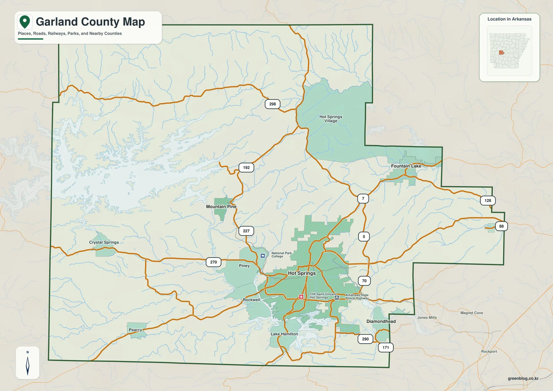
The county boundary adds useful context. Montgomery County lies to the west, Yell and Perry counties are along the northern side, Saline County is to the east, and Hot Spring County is to the south. The western edge sits close to the complex shoreline of Lake Ouachita, while the northern boundary crosses much higher mountain terrain. Hot Springs Village is particularly notable because the Encyclopedia of Arkansas describes it as a community that straddles the Garland-Saline county line, matching its position close to the northeastern edge of the map.
Major communities spread outward from the Hot Springs hub
The city-connections map uses Hot Springs as the hub and shows four surrounding communities with straight-line distances. Mountain Pine is about 8 miles from Hot Springs, Fountain Lake about 12 miles, Lonsdale about 15 miles, and Diamondhead about 7 miles. These are direct point-to-point distances, not driving mileage. That distinction matters in Garland County because lakes and steep ridges can force roads to curve well away from the straight line between two places.
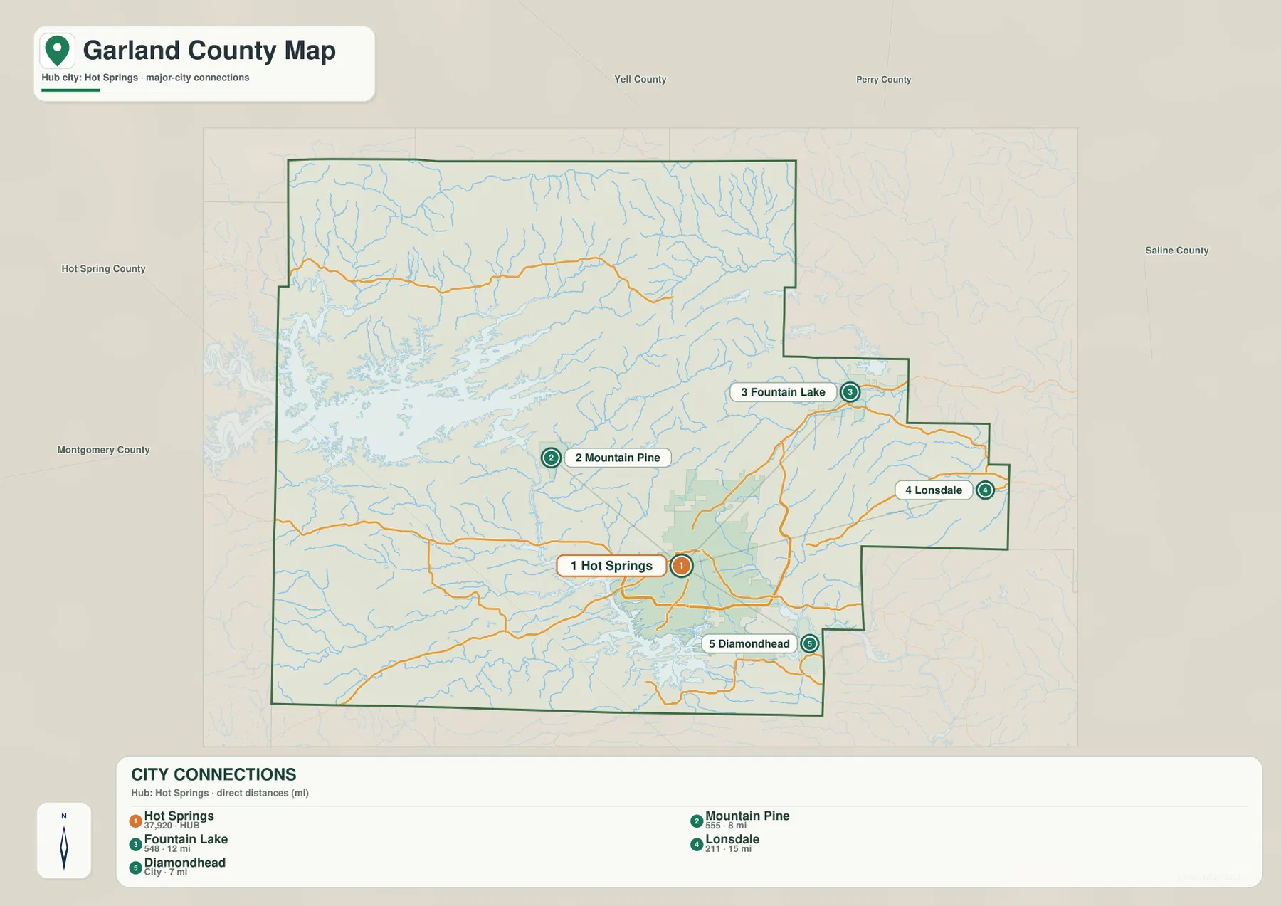
The distances are useful for orientation, but the locations tell an even clearer story. Mountain Pine lies toward Lake Ouachita and the northwestern hills. Fountain Lake and Lonsdale are east and northeast of the main city, while Diamondhead is southeast near the lower Lake Hamilton side of the county. A seven-mile direct line to Diamondhead may become a longer road trip because the route has to work around water and uneven terrain. For actual travel time, use a current navigation service after using this map to understand the larger layout.
Hot Springs also stands out strongly in the city hierarchy. The Encyclopedia of Arkansas identifies it as the county’s largest city and lists smaller places such as Mountain Pine, Fountain Lake, and Lonsdale elsewhere in the county. That pattern explains why so many major roads converge around Hot Springs while the surrounding communities occupy separate valleys and lake corridors. The city map is therefore most useful as a quick overview of how the main population center relates to the smaller communities around it.
Lake Ouachita dominates the west while Lake Hamilton shapes the south
Lake Ouachita is the largest water feature shown on the terrain and water map. Its branching shoreline fills a large part of western Garland County, with long narrow coves extending into mountain valleys. Arkansas State Parks describes Lake Ouachita as a major lake in the Ouachita Mountains, and the map makes that mountain setting obvious. The shoreline does not form a simple oval; it follows a network of drowned valleys, so the western part of the county is a mix of water, ridges, and narrow land connections.
South of Hot Springs, Lake Hamilton follows the Ouachita River through a long, narrow corridor with many inlets. Lake Balboa appears in the northeast near Hot Springs Village. Looking at all three lakes together helps explain why some roads and developed areas occupy narrow strips between water and higher ground. The lake system is not just a scenic backdrop on this map; it is one of the main reasons the county’s road pattern and settlement layout differ so much from flatter parts of Arkansas.
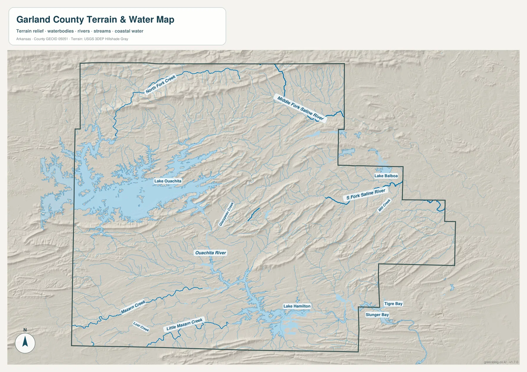
The named streams add detail to the lake picture. North Fork Creek crosses the northern side, and the Middle Fork Saline River appears near the northeastern boundary. The South Fork Saline River and Mill Creek occupy the eastern side. Southwest of Hot Springs, Mazarn Creek and Little Mazarn Creek run toward the Ouachita River and Lake Hamilton system. Many smaller tributaries follow narrow valleys between parallel ridges, which is why the water map and shaded terrain layer fit together so closely.
This map is intended for general geographic reference. It does not show current water levels, flood hazards, boating restrictions, fishing rules, parcel boundaries, or safe access to private land. Conditions on Lake Ouachita, Lake Hamilton, and smaller streams can change with weather and reservoir operations. For recreation or safety decisions, consult current information from Arkansas State Parks, USGS, or the agency responsible for the specific water body.
Northern Garland County rises well above the Hot Springs and lake corridors
The elevation map shows a countywide range of about 91 to 597 meters, with a mean near 210 meters. That is roughly 506 meters of difference between the lowest and highest mapped terrain. Darker brown and tan colors are concentrated across the north and northwest, where long ridges rise above the surrounding valleys. Around Hot Springs and the Lake Hamilton corridor, green colors cover a much larger area, indicating lower elevations compared with the northern mountains.
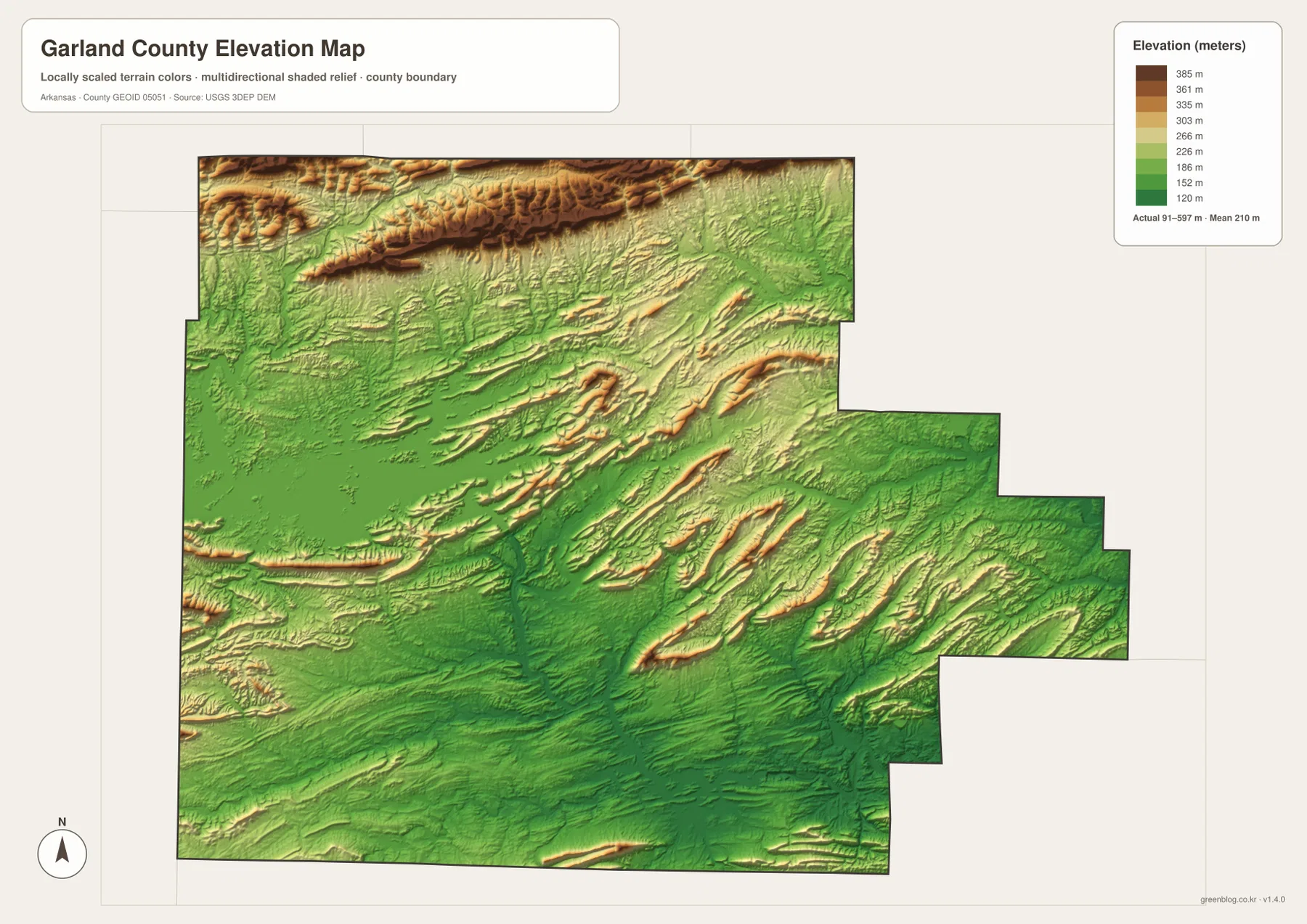
The Ouachita Mountains appear as a repeated series of long ridges rather than a single mountain mass. Across the northern edge, several high bands run roughly east-west with narrow valleys between them. Shorter ridges also surround the Hot Springs area and extend through the central and eastern parts of the county. In the Lake Ouachita area, coves reach into those valleys, so switching between the elevation and water maps makes the complicated shoreline easier to understand.
Hot Springs National Park is closely tied to this mountain setting. The National Park Service describes the park as a place of thermal springs, mountain views, geology, forests, trails, and creeks in the middle of the city. The elevation map helps explain why those natural features can exist so close to an urban center: Hot Springs sits among ridges rather than on a broad flat plain. The county elevation map is still a generalized reference surface, however, and should not be used for survey-grade heights on individual parcels, buildings, or roads.
Follow the maps from Hot Springs toward the lakes and mountain country
One useful way to compare the maps is to start at Hot Springs and move northwest. U.S. 270 leads toward the Pearcy side, while Highways 227 and 192 approach Mountain Pine and the eastern side of Lake Ouachita. On the water map, the same area contains long coves and numerous tributaries. On the elevation map, it becomes a closely packed pattern of ridges and valleys. Seeing the same corridor in three views explains why the roads curve and why the shoreline has so many narrow branches.
South of the city, Lake Hamilton provides a different reference point. Roads descend from Hot Springs into the lake corridor, where narrow water channels and peninsulas interrupt the lower terrain. Southeast toward Diamondhead, ridges return on both sides of the main road routes. Northeast toward Hot Springs Village, Lake Balboa and the Saline River drainage create another combination of water and hills. Garland County is easiest to understand when those directions are compared rather than trying to read every road, stream, and contour-like color at once.
High-resolution JPG files for printing and close viewing
The WebP images in the article are optimized for quick viewing on the page. The download ZIP contains the same four maps as high-resolution JPG files, each measuring 3638 × 2572 pixels in landscape orientation. Use the general map for roads and communities, the city-connections map for direct distance and direction from Hot Springs, the terrain and water map for lakes and named streams, and the elevation map for comparing the northern ridges with the lower Hot Springs and Lake Hamilton area.
The files are suitable for classroom reference, trip preparation, presentations, personal printing, and general orientation. They should not replace legal boundary records, parcel surveys, engineering plans, flood studies, or live navigation. When exact or current information matters, use Census TIGER/Line boundaries, USGS hydrography, USGS elevation data, and current information from the appropriate park, lake, or local agency.
Frequently Asked Questions
What is the county seat of Garland County?
Hot Springs is the county seat and the largest city in Garland County. It appears in the south-central part of the general map, where U.S. 270, U.S. 70, Highway 7, and several other routes connect with the surrounding communities. It is the most useful starting point for understanding the rest of the county.
Are the 7 to 15 mile values on the city map driving distances?
No. The city-connections map shows straight-line distances from Hot Springs: about 8 miles to Mountain Pine, 12 miles to Fountain Lake, 15 miles to Lonsdale, and 7 miles to Diamondhead. Driving distances may be longer because roads must curve around lakes, ridges, and valleys.
Where is the highest terrain in Garland County?
The highest terrain on this elevation map is concentrated across the northern and northwestern Ouachita Mountain ridges. The displayed countywide range is about 91–597 meters with a mean near 210 meters. Hot Springs and the Lake Hamilton corridor are generally lower than the northern uplands.
Map File Information
The ZIP contains the general county map, city-connections map, terrain and water map, and elevation map as high-resolution JPG files for printing or offline reference.
- File Type: ZIP containing 4 JPG files
Related Maps
Sources and references
- Encyclopedia of Arkansas – Garland County – county geography, Hot Springs, communities, and local history
- National Park Service – Hot Springs National Park – official information on the thermal springs, mountains, forests, trails, and creeks
- Arkansas State Parks – Lake Ouachita State Park – official state park information for the Lake Ouachita area
- U.S. Census Bureau TIGER/Line Shapefiles – county boundary and road data
- USGS National Hydrography – rivers, streams, and waterbody data
- USGS 3D Elevation Program – elevation and terrain data
Green Map creates custom-edited map images using open geographic data sources such as geoBoundaries, Natural Earth, OpenStreetMap, and government open data.
These maps are edited visual materials, not raw data files, and are provided for education, documents, presentations, and graphic reference.